Listings on islands considered part of New York County
| [3] | Name on the Register | Image | Date listed [4] | Location | City or town | Description |
|---|---|---|---|---|---|---|
| 1 | Admiral's House |  | July 24, 1972 (#72000860) | Nolan Park 40°41′25″N74°00′50″W / 40.690278°N 74.013889°W | Governors Island | Used by the commanding officers of the Army and Coast Guard units. |
| 2 | Blackwell House | 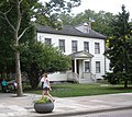 | February 25, 1972 (#72000862) | 501 Main Street, Roosevelt Island (formerly Welfare Island) 40°45′38″N73°57′05″W / 40.760556°N 73.951389°W | Roosevelt Island | Built in 1796 by a descendant of the first English owner of the island |
| 3 | Block House |  | July 24, 1972 (#72000863) | Nolan Park on Barry Road 40°41′20″N74°00′51″W / 40.688889°N 74.014167°W | Governors Island | A small military prison on Governors Island. |
| 4 | Castle Williams |  | July 31, 1972 (#72000864) | Hay Road and Andes Road 40°41′34″N74°01′11″W / 40.692778°N 74.0197°W | Governors Island | A circular 19th century fortification of red sandstone on the northwest point of Governors Island, part of a system of forts to protect New York City from naval attack. Now part of Governors Island National Monument. |
| 5 | Chapel of the Good Shepherd |  | March 16, 1972 (#72000865) | 543 Main Street 40°45′42″N73°57′02″W / 40.761667°N 73.950556°W | Roosevelt Island | A historic Episcopal church designed by architect Frederick Clarke Withers, now known as the Good Shepherd Community Ecumenical Center |
| 6 | City Hospital |  | March 16, 1972 (#72000868) | Between Road 3 and South Loop Road 40°45′11″N73°57′31″W / 40.753056°N 73.958611°W | Roosevelt Island | Built in 1861 by James Renwick Jr. to replace the earlier Penitentiary hospital. Demolished in 1994. |
| 7 | Fort Jay |  | March 27, 1974 (#74001268) | Quadrangle Road 40°41′29″N74°00′59″W / 40.691389°N 74.016389°W | Governors Island | A 1794 coastal star fort, built to defend New York Harbor. Now part of Governors Island National Monument. |
| 8 | Governor's House |  | April 26, 1973 (#73001217) | Building 2, Andes Road 40°41′27″N74°00′48″W / 40.690833°N 74.013333°W | Governors Island | A historic house on Governors Island. |
| 9 | Governors Island |  | February 4, 1985 (#85002435) | Governors Island 40°41′26″N74°01′00″W / 40.690556°N 74.016667°W | Governors Island | A 172-acre (70 ha) island in New York Harbor which has been expanded over time. Used by various military forces over time, it is now used for a variety of purposes. |
| 10 | Lighthouse |  | March 16, 1972 (#72000876) | North end of Roosevelt Island 40°46′22″N73°56′26″W / 40.772778°N 73.940556°W | Roosevelt Island | An 1872 lighthouse located at the northeast tip of Roosevelt Island in the East River. |
| 11 | The Octagon |  | March 16, 1972 (#72000880) | 888 Main Street 40°46′08″N73°56′38″W / 40.768889°N 73.943889°W | Roosevelt Island | Originally serving as the main entrance to the New York City Lunatic Asylum, which opened in 1841, it was designed by Alexander Jackson Davis. |
| 12 | Smallpox Hospital | 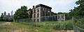 | March 16, 1972 (#72000881) | E Road 40°45′06″N73°57′36″W / 40.751667°N 73.96°W | Roosevelt Island | Originally designed by architect James Renwick Jr., the 100-bed hospital opened in 1856, when the area was known as Blackwell's Island. Its ruins have been stabilized and preserved. |
| 13 | Statue of Liberty Enlightening the World |  | September 14, 2017 (#100000829) | Liberty Island, New York Harbor 40°41′21″N74°02′40″W / 40.689154°N 74.044441°W | Liberty Island | The iconic statue named Liberty Enlightening the World |
| 14 | Statue of Liberty National Monument, Ellis Island and Liberty Island |  | October 15, 1966 (#66000058) | Liberty Island and Ellis Island, New York Harbor 40°41′38″N74°02′37″W / 40.693889°N 74.043611°W | Liberty Island and Ellis Island | A National Monument that includes, Liberty Enlightening the World, commonly known as the Statue of Liberty, situated on Liberty Island, and the former immigration station at Ellis Island, including the Ellis Island Immigrant Hospital. |
| 15 | Strecker Memorial Laboratory | 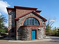 | March 16, 1972 (#72000886) | E Road 40°45′09″N73°57′31″W / 40.7525°N 73.958611°W | Roosevelt Island | Built in 1892 to serve as a laboratory for City Hospital, it was "the first institution in the nation for pathological and bacteriological research." The building was designed by architects Frederick Clarke Withers and Walter Dickson in the Romanesque Revival style. |

