Little Red Lighthouse

Last updated
Jeffrey's Hook Light
Little Red Lighthouse
Little Red Lighthouse, Fort Washington Park.jpg
Little Red Lighthouse
Location Fort Washington Park, Manhattan, US
Coordinates 40°51′01″N73°56′49″W / 40.8503°N 73.9469°W / 40.8503; -73.9469
Tower
Constructed1921  OOjs UI icon edit-ltr-progressive.svg
Constructionconcrete (foundation), cast iron (tower)  OOjs UI icon edit-ltr-progressive.svg
Height40 ft (12 m)  OOjs UI icon edit-ltr-progressive.svg
Shapeconical  OOjs UI icon edit-ltr-progressive.svg
Markingsred (tower), white (lantern)  OOjs UI icon edit-ltr-progressive.svg
HeritageNew York City Landmark, National Register of Historic Places listed place  OOjs UI icon edit-ltr-progressive.svg
Light
First lit2002  OOjs UI icon edit-ltr-progressive.svg
Deactivated1947–2002
Lens12 inches (300 mm)
Characteristic Fl R 3s  OOjs UI icon edit-ltr-progressive.svg
Jeffrey's Hook Lighthouse
Built1920
MPS Hudson River Lighthouses TR
NRHP reference No. 79003130 [1]
Significant dates
Added to NRHPMay 29, 1979
Designated NYCLMay 14, 1991

The Little Red Lighthouse, officially Jeffrey's Hook Light, is a small lighthouse located in Fort Washington Park along the Hudson River in Manhattan, New York City, under the George Washington Bridge. [2] [3] [4] It was made notable by the 1942 children's book The Little Red Lighthouse and The Great Gray Bridge, written by Hildegarde Swift and illustrated by Lynd Ward.

Contents

The lighthouse stands on Jeffrey's Hook, a small point of land that supports the base of the eastern pier of the bridge, which connects Washington Heights in Manhattan to Fort Lee, New Jersey.

History

The first attempt to reduce Hudson River traffic accidents at Jeffrey's Hook was a red pole that was hung out over the river. [5] A 10 candle-power light was added to the pole in 1889 to help alert the increasing river traffic to the spit of land at night. The land around Jeffrey's Hook was acquired by the city in 1896 and later became Fort Washington Park. [5]

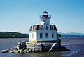
The early structure was built as the North Hook Beacon at Sandy Hook, New Jersey, where it stood until 1917, when it became obsolete. [5] It was reconstructed at its current location in 1921 by the United States Lighthouse Board as part of a project to improve Hudson River navigational aids, and originally had a battery-powered lamp and a fog bell. It was operated by a part-time lighthouse keeper. [5]

Construction on the George Washington Bridge, immediately above the lighthouse, started in 1927. [6] When George Washington Bridge was completed in 1931, [7] the lighthouse navigational light was considered obsolete, [8] so the Coast Guard decommissioned it, and put it out in 1948, with the intention of auctioning it off. [5] The proposed dismantling of it resulted in a public outcry, largely from children who were fans of the 1942 children's book, The Little Red Lighthouse and the Great Gray Bridge. [9] This led the Coast Guard to sign its deed to the New York City Department of Parks and Recreation on July 23, 1951. [5]

The lighthouse was listed on the National Register of Historic Places as "Jeffrey's Hook Lighthouse" in 1979, [10] and was designated a New York City Landmark in 1991. [5] In 2002, it was relit by the city. [4]

Access

Public access to the lighthouse is by the Hudson River Greenway, reachable north of the George Washington Bridge by a footbridge across the Henry Hudson Parkway at West 182nd Street and Riverside Drive, and south of the bridge by a footbridge at West 158th Street or the newer Denny Farrell Greenway Bridge (a pedestrian and bicycle bridge) at 151st Street. [11] The northern path is very steep immediately north of the bridge, while the southern path is flat.

There is also a very obscure pedestrian underpass at Riverside Drive parallel to 177th Street, just south of the George Washington Bridge. It empties out on the other side of the Henry Hudson Parkway and it's a dirt path down to the lighthouse. This YouTube video [12] gives directions for getting to and using this obscure path. A neighborhood group (Friends of J. Hood Wright Park) in partnership with the NYC Department of Parks and Recreation does monthly cleanups of this route. [13]

There is yet another way to get to the Little Red Lighthouse from Washington Heights. This link [14] shows the path using the Haven Ramp to the Little Red Lighthouse and then returns via this other path that takes you out to Riverside Drive on the west side of NewYork-Presbyterian Hospital. From there one can walk south to 165th Street.

Tours of the lighthouse are given infrequently. They are arranged by the Parks Department's Urban Park Rangers, especially on the Little Red Lighthouse Festival day in late September and Open House New York day in October. The October Little Red Lighthouse Festivals in 2018 and 2019 were run by the organization Summer on the Hudson [15] in conjunction with the Riverside Park Conservancy [16] and the New York City Department of Parks and Recreation. The festival was not held in 2020 or 2021 due to the COVID-19 Pandemic but it resumed in 2022. [17]

In other media

The lighthouse is an important setting in the final scenes for the 1948 film Force of Evil , and Jane Campion's neo-noir film In the Cut features the lighthouse as motif and as a filming location. [18]

See also

Related Research Articles

<span class="mw-page-title-main">Washington Heights, Manhattan</span> Neighborhood in New York City

Washington Heights is a neighborhood in the northern part of the borough of Manhattan in New York City. It is named for Fort Washington, a fortification constructed at the highest natural point on Manhattan by Continental Army troops to defend the area from the British forces during the American Revolutionary War. Washington Heights is bordered by Inwood to the north along Dyckman Street, by Harlem to the south along 155th Street, by the Harlem River and Coogan's Bluff to the east, and by the Hudson River to the west.

<span class="mw-page-title-main">Inwood Hill Park</span> Public park in Manhattan, New York

Inwood Hill Park is a public park in the Inwood neighborhood of Manhattan, New York City, operated by the New York City Department of Parks and Recreation. On a high schist ridge that rises 200 feet (61 m) above the Hudson River from Dyckman Street to the northern tip of the island, Inwood Hill Park's densely folded, glacially scoured topography contains the largest remaining old-growth forest on Manhattan Island, known as the Shorakapok Preserve after a historic Wecquaesgeek village. Unlike other Manhattan parks, Inwood Hill Park is largely natural and consists of mostly wooded, non-landscaped hills.

<span class="mw-page-title-main">Riverside Park (Manhattan)</span> Public park in New York City

Riverside Park is a scenic waterfront public park in the Upper West Side, Morningside Heights, and Hamilton Heights neighborhoods of the borough of Manhattan in New York City. The park measures 4 miles (6.4 km) long and 100 to 500 feet wide, running between the Hudson River and Henry Hudson Parkway to the west and the serpentine Riverside Drive to the east.

<span class="mw-page-title-main">New York–New Jersey Harbor Estuary</span> One of the most intricate natural harbors in the world

The New York–New Jersey Harbor Estuary, also known as the Hudson-Raritan Estuary, is in the northeastern states of New Jersey and New York on the East Coast of the United States. The system of waterways of the Port of New York and New Jersey forms one of the most intricate natural harbors in the world and one of the busiest ports of the United States. The harbor opens onto the New York Bight in the Atlantic Ocean to the southeast and Long Island Sound to the northeast.

<span class="mw-page-title-main">Fort Tryon Park</span> Public park in Manhattan, New York

Fort Tryon Park is a public park located in the Washington Heights and Inwood neighborhoods of the borough of Manhattan in New York City. The 67-acre (27 ha) park is situated on a ridge in Upper Manhattan, close to the Hudson River to the west. It extends mostly from 192nd Street in the south to Riverside Drive in the north, and from Broadway in the east to the Henry Hudson Parkway in the west. The main entrance to the park is at Margaret Corbin Circle, at the intersection of Fort Washington Avenue and Cabrini Boulevard.

<span class="mw-page-title-main">Upper Manhattan</span> Neighborhood in New York City

Upper Manhattan is the most northern region of the New York City borough of Manhattan. Its southern boundary has been variously defined, but some of the most common usages are 96th Street, the northern boundary of Central Park, 125th Street, or 155th Street. The term Uptown can refer to Upper Manhattan, but is often used more generally for neighborhoods above 59th Street; in the broader definition, Uptown encompasses Upper Manhattan.

<span class="mw-page-title-main">High Bridge (New York City)</span> Bridge between Manhattan and the Bronx, New York

The High Bridge is the oldest bridge in New York City, having originally opened as part of the Croton Aqueduct in 1848 and reopened as a pedestrian walkway in 2015 after being closed for over 45 years. A steel arch bridge with a height of 140 ft (43 m) over the Harlem River, it connects the New York City boroughs of the Bronx and Manhattan. The eastern end is located in the Highbridge section of the Bronx near the western end of West 170th Street, and the western end is located in Highbridge Park in Manhattan, roughly parallel to the end of West 174th Street.

<span class="mw-page-title-main">Nyack Beach State Park</span> State park in Rockland County, New York

Nyack Beach State Park is a 61-acre (0.25 km2) state park in Upper Nyack, Rockland County, New York. It consists of a small parking lot and a riverfront pathway, the southernmost section of the Hudson River Valley Greenway. It is known for its physical proximity to the Hudson River on one side of the pathway and the looming cliffs of the Palisades rising 700 feet (210 m) above on the other side.

<span class="mw-page-title-main">National Register of Historic Places listings in New York</span>

Buildings, sites, districts, and objects in New York listed on the National Register of Historic Places:

<span class="mw-page-title-main">Hudson Heights, Manhattan</span> Neighborhood of Manhattan in New York City

Hudson Heights is a residential neighborhood within Washington Heights in Upper Manhattan, New York City. Most residences are apartment buildings, many of which are cooperatives, and most were constructed in the 1920s through 1940s. The Art Deco style is prominent, along with Tudor Revival. Notable complexes include Hudson View Gardens and Castle Village, which were both developed by Dr. Charles V. Paterno, and were designed by George F. Pelham and his son, George F. Pelham, Jr., respectively.

<span class="mw-page-title-main">Port of New York and New Jersey</span> Port in New York and New Jersey, United States

The Port of New York and New Jersey is the port district of the New York-Newark metropolitan area, encompassing the region within approximately a 25-mile (40 km) radius of the Statue of Liberty National Monument.

<span class="mw-page-title-main">Raritan Bayshore</span> Region of New Jersey

The Raritan Bayshore is a region in central sections in the state of New Jersey. It is the area around Raritan Bay from The Amboys to Sandy Hook, in Middlesex and Monmouth counties, including the towns of Perth Amboy, South Amboy, Sayreville, Old Bridge, Matawan, Aberdeen, Keyport, Union Beach, Hazlet, Keansburg, Middletown, Atlantic Highlands, and Highlands. It is the northernmost part of the Jersey Shore, located just south of New York City. At Keansburg is a traditional amusement park while at Sandy Hook are found ocean beaches. The Sadowski Parkway beach area in Perth Amboy, which lies at the mouth of the Raritan River, was deemed the "Riviera of New Jersey" by local government. In recent years many of the beaches on the Bayshore area have been rediscovered and upgraded.

<span class="mw-page-title-main">Highbridge Park</span> Public park in Manhattan, New York

Highbridge Park is a public park on the western bank of the Harlem River in Washington Heights, Manhattan, New York City. It stretches between 155th Street and Dyckman Street in Upper Manhattan. The park is operated by the New York City Department of Parks and Recreation. The City maintains the southern half of the park, while the northern half is maintained by the non-profit New York Restoration Project. Prominent in the park are the Manhattan end of the High Bridge, the High Bridge Water Tower, and the Highbridge Play Center.

<span class="mw-page-title-main">Fort Washington Park (Manhattan)</span> Public park in Manhattan, New York

Fort Washington Park is a public park located in the Washington Heights section of Upper Manhattan in New York City. It runs along the banks of the Hudson River next to Riverside Drive and the Henry Hudson Parkway from West 155th Street to Dyckman Street. The George Washington Bridge crosses above the park; below the bridge is a small point of land called Jeffrey's Hook, which is the site of the Little Red Lighthouse.

<span class="mw-page-title-main">Fort Washington (Manhattan)</span> United States historic place

Fort Washington was a fortified position near the north end of Manhattan Island, at the island's highest point, within the modern-day neighborhood of Washington Heights in New York City. The Fort Washington Site is listed on the National Register of Historic Places.

<span class="mw-page-title-main">Manhattan Waterfront Greenway</span> Esplanade in Manhattan, New York

The Manhattan Waterfront Greenway is a waterfront greenway for walking or cycling, 32 miles (51 km) long, around the island of Manhattan, in New York City. The largest portions are operated by the New York City Department of Parks and Recreation. It is separated from motor traffic, and many sections also separate pedestrians from cyclists. There are three principal parts — the East, Harlem and Hudson River Greenways.

<span class="mw-page-title-main">Hudson River Waterfront Walkway</span> Park in the United States of America

The Hudson River Waterfront Walkway, also known as the Hudson River Walkway, is a promenade along the Hudson Waterfront in New Jersey. The ongoing and incomplete project located on Kill van Kull and the western shore of Upper New York Bay and the Hudson River was implemented as part of a New Jersey state-mandated master plan to connect the municipalities from the Bayonne Bridge to the George Washington Bridge with an urban linear park and provide contiguous unhindered access to the water's edge.

<span class="mw-page-title-main">Tarrytown Light</span> Lighthouse in New York, United States

Tarrytown Light, also known as Kingsland Point Light and Sleepy Hollow Light, is a sparkplug lighthouse on the east side of the Hudson River in Sleepy Hollow, New York, United States. It a conical steel structure erected in the 1880s. In 1979 it was listed on the National Register of Historic Places.

<span class="mw-page-title-main">Hook Mountain State Park</span> State park in Rockland County, New York

Hook Mountain State Park is a 676-acre (2.74 km2) undeveloped state park located in Rockland County, New York. The park includes a portion of the Hudson River Palisades on the western shore of the Hudson River, and is part of the Palisades Interstate Park system. Hook Mountain State Park is functionally part of a continuous complex of parks that also includes Rockland Lake State Park, Nyack Beach State Park, and Haverstraw Beach State Park.

<span class="mw-page-title-main">Plaza Lafayette</span> Plaza in Manhattan, New York

Plaza Lafayette is a small, 0.09-acre (0.036 ha) park and surrounding streets in the Hudson Heights neighborhood of Washington Heights, Manhattan, New York City. Named after the Marquis de Lafayette, the French hero of the American Revolution, the park is roughly trapezoidal in shape, and is bounded by Riverside Drive – originally called Boulevard Lafayette in this area – on the west, the westbound lane of West 181st Street – also called "Plaza Lafayette" here – on the north, the eastbound lane of West 181st Street/Plaza Lafayette on the south, and Haven Avenue on the east. The land was acquired by the city on February 23, 1918.

References

  1. "National Register Information System". National Register of Historic Places . National Park Service. March 13, 2009.
  2. Light List, Volume I, Atlantic Coast, St. Croix River, Maine to Shrewsbury River, New Jersey (PDF). Light List. United States Coast Guard. 2009. p. 312.
  3. "Historic Light Station Information and Photography: New York". United States Coast Guard Historian's Office. Archived from the original on 2017-05-01.
  4. 1 2 Rowlett, Russ (2009-12-28). "Lighthouses of the United States: Downstate New York". The Lighthouse Directory. University of North Carolina at Chapel Hill.
  5. 1 2 3 4 5 6 7 New York City Department of Parks and Recreation. Historic plaque on the lighthouse
  6. "GROUND IS BROKEN FOR HUDSON BRIDGE; Acting Mayor McKee Digs Earth at 178th Street, Mayor White on New Jersey Shore. PLANES SOAR OVER RIVER Governors of Both States Heard by Radio on Both Banks From Steamer in Hudson. SEE FRIENDSHIP CEMENTED Smith Says Span Will Increase Prosperity -- Moore Calls It Monument to Progressive Spirit". The New York Times. September 22, 1927. ISSN   0362-4331 . Retrieved June 5, 2018.
  7. "Two Governors Open Great Hudson Bridge As Throngs Look On". The New York Times. October 25, 1931. ISSN   0362-4331 . Retrieved March 6, 2010.
  8. White, Norval; Willensky, Elliot; Leadon, Fran (2010). AIA Guide to New York City (5th ed.). New York: Oxford University Press. p. 570. ISBN   978-0-19538-386-7.
  9. New York City Landmarks Preservation Commission; Dolkart, Andrew S.; Postal, Matthew A. (2009). Postal, Matthew A. (ed.). Guide to New York City Landmarks (4th ed.). New York: John Wiley & Sons. ISBN   978-0-470-28963-1., p.213
  10. "Little Red Lighthouse" Archived 2010-12-30 at the Wayback Machine , Washington Heights & Inwood Online, NYC Dept. of Parks & Recreation, August 2001, accessed February 27, 2012
  11. Walsh, Kevin (16 January 2018). "HERMAN "DENNY" FARRELL BRIDGE, Washington Heights". Forgotten New York. Retrieved 6 April 2022.
  12. DeMarco, Joe. "How to get to The Little Red Lighthouse in Upper Manhattan - NYC". YouTube. Retrieved 6 April 2022.
  13. Gershenhorn, Ira (12 December 2020). "Haven Avenue Ramp 2020-1212". Flickr. Retrieved 6 April 2022.
  14. Crowley, Jim (20 June 2012). "Road to the Little Red Lighthouse". Hope Farm Press 2000. Retrieved 6 April 2022.
  15. "Summer on the Hudson". www.nycgovparks.org. New York City Department of Parks & Recreation. Retrieved 6 April 2022.
  16. "The Riverside Park Conservancy". The Riverside Park Conservancy. Retrieved 6 April 2022.
  17. "Summer on the Hudson: Little Red Lighthouse Festival". www.nycgovparks.org. New York City Department of Parks & Recreation. Archived from the original on 16 May 2023. Retrieved 16 May 2023.{{cite web}}: CS1 maint: bot: original URL status unknown (link)
  18. Rockland, Michael Aaron (2008). The George Washington Bridge: Poetry in Steel. Rutgers University Press. pp. 124–25. ISBN   9780813545547.