
Broadway is a road in the U.S. state of New York. Broadway runs from State Street at Bowling Green for 13 mi (21 km) through the borough of Manhattan and 2 mi (3.2 km) through the Bronx, exiting north from New York City to run an additional 18 mi (29 km) through the Westchester County municipalities of Yonkers, Hastings-On-Hudson, Dobbs Ferry, Irvington, and Tarrytown, and terminating north of Sleepy Hollow.

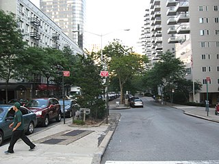
Washington Heights is a neighborhood in the northernmost part of the New York City borough of Manhattan. It is named for Fort Washington, a fortification constructed at the highest natural point on Manhattan by Continental Army troops to defend the area from the British forces during the American Revolutionary War. Washington Heights is bordered by Inwood to the north along Dyckman Street, by Harlem to the south along 155th Street, by the Harlem River and Coogan's Bluff to the east, and by the Hudson River to the west.

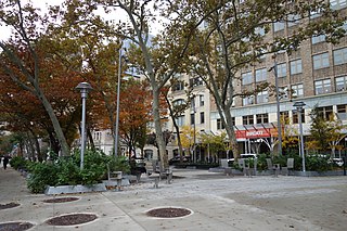
Bennett Park, also known as James Gordon Bennett Park, is a 1.8-acre (0.73 ha) public park in New York City, named for James Gordon Bennett, Sr., the newspaper publisher who launched the New York Herald in 1835. It is located between Pinehurst and Fort Washington Avenues and West 183rd and 185th Streets in the Hudson Heights neighborhood of Washington Heights in northern Manhattan, on land purchased by Bennett in 1871, the year before his death. It sits opposite the northern Fort Washington Avenue entrance to the 181st Street subway station on the IND Eighth Avenue Line, serviced by the A train.

Manhattan Valley is a neighborhood in the northern part of Upper West Side in Manhattan, New York City. It is bounded by West 110th Street to the north, Central Park West to the east, West 96th Street to the south, and Broadway to the west.
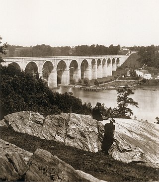
The Croton Aqueduct or Old Croton Aqueduct was a large and complex water distribution system constructed for New York City between 1837 and 1842. The great aqueducts, which were among the first in the United States, carried water by gravity 41 miles (66 km) from the Croton River in Westchester County to reservoirs in Manhattan. It was built because local water resources had become polluted and inadequate for the growing population of the city. Although the aqueduct was largely superseded by the New Croton Aqueduct, which was built in 1890, the Old Croton Aqueduct remained in service until 1955.

Lincoln Square is the name of both a square and the surrounding neighborhood within the Upper West Side of the New York City borough of Manhattan. Lincoln Square is centered on the intersection of Broadway and Columbus Avenue, between West 65th and West 66th streets. The neighborhood is bounded by Columbus Avenue and Amsterdam Avenue to the east and west, and West 66th and 63rd Street to the north and south. However, the term can be extended to refer to the neighborhood between West 59th Street and West 72nd Street. It is bounded by Hell's Kitchen, Riverside South, Central Park, and the Upper West Side proper. The studios for WABC-TV are located here.

St. Nicholas Avenue is a major street that runs obliquely north-south through several blocks between 111th and 193rd Streets in the New York City borough of Manhattan. The route, which follows a course that is much older than the grid pattern of the Commissioners' Plan of 1811, passes through the neighborhoods of Harlem, Hamilton Heights, and Washington Heights. It is believed to follow the course of an old Indian trail that became an important road in the 17th century between the Dutch settlement of New Amsterdam and the British New England Colonies. In the post colonial era, it became the western end of the Boston Post Road. The road became a street when row housing was being built in Harlem during its rapid urban expansion following the end of the American Civil War.

Dante Park is a public park in Manhattan, New York City, located in the Upper West Side neighborhood in front of Lincoln Center near Central Park.
66th Street is a crosstown street in the New York City borough of Manhattan with portions on the Upper East Side and Upper West Side connected across Central Park via the 66th Street transverse. West 66th Street is notable for hosting the Lincoln Center for the Performing Arts between Broadway and Columbus Avenue.

Stuyvesant Square is the name of both a park and its surrounding neighborhood in the New York City borough of Manhattan. The park is located between 15th Street, 17th Street, Rutherford Place, and Nathan D. Perlman Place. Second Avenue divides the park into two halves, east and west, and each half is surrounded by the original cast-iron fence.
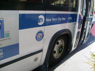
MTA Regional Bus Operations operates local and express buses serving New York City in the United States out of 29 bus depots. These depots are located in all five boroughs of the city, with the exception of one located in nearby Yonkers in Westchester County. 21 of these depots serve MTA New York City Transit (NYCT)'s bus operations, while the remaining eight serve the MTA Bus Company These facilities perform regular maintenance, cleaning, and painting of buses, as well as collection of revenue from bus fareboxes. Several of these depots were once car barns for streetcars, while others were built much later and have only served buses. Employees of the depots are represented by local divisions of the Transport Workers Union of America (TWU), particularly the TWU Local 100 and 101, or of the Amalgamated Transit Union (ATU)'s Local's 726 for all depots in Staten Island, 1056 for Casey Stengel, Jamaica, and Queens Village Depots, and 1179 for JFK & Far Rockaway Depots.

Audubon Avenue is an avenue in the Washington Heights neighborhood in Upper Manhattan that runs north-south, west of and parallel to Amsterdam Avenue. Its southern terminus is at West 165th Street and St. Nicholas Avenue, and its northern terminus is at Fort George Avenue, just north of West 193rd Street. It crosses over the Trans-Manhattan Expressway, east of the eastern portal of the expressway's tunnel.
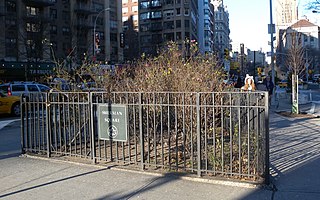
Sherman Square is a pocket park bounded by Broadway, Amsterdam Avenue, and West 70th Street on the Upper West Side of Manhattan, in New York City. It was named in 1891 for William Tecumseh Sherman who lived in the area and died that year.

155th Street is a crosstown street separating the Harlem and Washington Heights neighborhoods, in the New York City borough of Manhattan. It is the northernmost of the 155 crosstown streets mapped out in the Commissioner's Plan of 1811 that established the numbered street grid in Manhattan. The street consists of a "high portion" which is a major artery through the area, as well as a lesser-used "low portion".

The Jacqueline Kennedy Onassis Reservoir, also known as Central Park Reservoir, is a decommissioned reservoir in Central Park in the borough of Manhattan, New York City, stretching from 86th to 96th Streets. It covers 106 acres (43 ha) and holds over 1 billion US gal (3.8 million m3) of water.

Mitchel Square Park is a small urban park in the Washington Heights neighborhood of the New York City borough of Manhattan. It is a two part, triangle-shaped park formed by the intersection of Saint Nicholas Avenue, Broadway and 167th Street.

Jackson Square Park is an urban park in the Greenwich Village Historic District in Manhattan, New York City, United States. The 0.227 acres (920 m2) park is bordered by 8th Avenue on the west, Horatio Street on the south, and Greenwich Avenue on the east. The park interrupts West 13th Street.
Spring Street Park is a small triangular park in the lower Manhattan neighborhood of Hudson Square in New York City. The park is bounded by Spring Street on the north, Broome Street on the south, Avenue of the Americas on the east, and on the west by a narrow two-block street considered to be a spur of Sixth Avenue. As a pedestrian plaza, the triangle was previously known as SoHo Square.
