Collect Pond

Last updated
A 1798 watercolor of Collect Pond. Bayard's Mount, a 110-foot (34 m) hillock, is in the left foreground. Prior to being levelled around 1811 it was located near the current intersection of Mott and Grand Streets. New York City, which then extended to a stockade which ran approximately north-southeast from today's Chambers Street and Broadway, is visible beyond the southern shore. Collect Pond-Bayard Mount-NYC (cropped).jpg
A 1798 watercolor of Collect Pond. Bayard's Mount, a 110-foot (34 m) hillock, is in the left foreground. Prior to being levelled around 1811 it was located near the current intersection of Mott and Grand Streets. New York City, which then extended to a stockade which ran approximately north–southeast from today's Chambers Street and Broadway, is visible beyond the southern shore.

Collect Pond, or Fresh Water Pond, [1] was a body of fresh water in what is now Chinatown in Lower Manhattan, New York City. For the first two centuries of European settlement in Manhattan, it was the main New York City water supply system for the growing city. A jail was later built on the former pond. In the 20th century, the site became Collect Pond Park ( 40°42′59″N74°00′07″W / 40.7163°N 74.0019°W / 40.7163; -74.0019 ), which includes a reflecting pool to acknowledge the historic importance of this body of water.

Contents

Pond description

The pond occupied approximately 48 acres (190,000 m2) and was as deep as 60 feet (18 m). [1] Fed by an underground spring, it was located in a valley, with Bayard Mount (at 110 feet or 34 metres the tallest hill in lower Manhattan) to the northeast and Kalck Hoek (Dutch for Chalk Point, named for the numerous oyster shell middens left by the indigenous Native American inhabitants) to the west. A stream flowed north out of the pond and then west through a salt marsh (which, after being drained, became a meadow by the name of "Lispenard Meadows") to the Hudson River, while another stream issued from the southeastern part of the pond in an easterly direction to the East River.

The southwestern shore of Collect Pond was the site of a Native American settlement known as Werpoes. A small band of Munsee, the northernmost division of the Lenape, occupied the site. The Munsee continued to live at Collect Pond until the Dutch settlement of New Amsterdam was established in the 17th century. It is possible that members of this band were the participants in the "sale" of Manhattan to the Dutch.

Collect Pond was used as a terms of boundary for night watch duties in 1731 under John Montgomerie's charter during the British rule in New York City. [2] The pond was home to a copious amount of fish, and in 1734 legislation was passed preventing the use of nets in the pond. This was prior to the extreme pollution to the pond, which included the dumping of dead animals. [3]

18th century

Collect Pond and Five Points on the topographical map by Egbert Viele. The Five Points intersection is where Mosco Street (marked here as Park Street) intersected with Baxter Street (formerly Orange Street) and Worth Street (formerly Anthony Street). Viele Map Collect Pond Five Points.jpg
Collect Pond and Five Points on the topographical map by Egbert Viele. The Five Points intersection is where Mosco Street (marked here as Park Street) intersected with Baxter Street (formerly Orange Street) and Worth Street (formerly Anthony Street).

In the 18th century, the pond was used as a picnic area during summer and a skating rink during the winter. [4] Beginning in the early 18th century, various commercial enterprises were built along the shores of the pond in order to use the water. These businesses included Coulthards Brewery, Nicholas Bayard's slaughterhouse on Mulberry Street (which was nicknamed "Slaughterhouse Street"), [5] numerous tanneries on the southeastern shore, and the pottery works of German immigrants Johan Willem Crolius and Johan Remmey on Pot Bakers Hill on the south-southwestern shore. [6] By the late 18th century, the pond was considered "a very sink and common sewer". [1]

John Fitch's steamboat experiment

Fitch testing his steamboat on the Collect Pond Testing steam propulsion on New York's Collect Pond.png
Fitch testing his steamboat on the Collect Pond
John Fitch's steamboat experiment on Collect Pond 1846 Broadside of the Collect Pond, New York and Steam Boat ( Five Points ) - Geographicus - CollectPond-hutchings-1846.jpg
John Fitch's steamboat experiment on Collect Pond

Connecticut inventor John Fitch was an instrument maker working in the later part of the 18th century. As an early pioneer of steam navigation, Fitch tested several steamboats on the Delaware River between 1785 and 1788. Fitch’s real success, however, occurred in 1796 when he tested another ship equipped with a paddle wheel on Collect Pond. On the boat with him was fellow inventor Robert Fulton, Robert R. Livingston, who was the first Chancellor of New York and a signer of the Declaration of Independence, and 16-year-old John Hutchings, steering. [7]

This was six years before Fulton and Livingston launched “Fulton’s Folly” on the Seine River in France. Hutchings claims to have been a “lad” at the time who “assisted Mr. Fitch in steering the boat”. In a broadside issued in 1846, Hutchings asserts that it was in fact Fitch who designed the steam propulsion mechanism. He claims that both Fulton and Livingston were present during Collect Pond tests and in fact depicts both, as well as Fitch and himself, in a paddlewheel steam ship in the upper left quadrant of the broadside. Though Fulton seems to have received most of the credit for the era of steam navigation, Hutchings hoped, through the publication of this broadside, to shed some light on Fitch’s contributions as well. A plaque at Collect Pond Park, however, states that though Fitch's account "is often repeated, no evidence has been found to substantiate the story."

Contamination and landfill

The contaminated wastewater of the businesses surrounding the pond flowed back into the pond, creating a severe pollution problem and environmental health hazard. Pierre Charles L'Enfant proposed cleaning the pond and making it a centerpiece of a recreational park, around which the residential areas of the city could grow. His proposal was rejected, and it was decided to drain and fill in the pond. This was accomplished with soil partially obtained from leveling the nearby hills of Bayard's Mount and Kalck Hoek, and by digging a canal to the north to encourage the water to drain into the river. The landfill was completed in 1811, and middle class homes were soon built on the reclaimed land. [8] [1]

The landfill was poorly engineered. The buried vegetation began to release methane gas (a byproduct of decomposition) and the area, still in a natural depression, lacked adequate storm sewers. As a result, the ground gradually subsided. Houses shifted on their foundations, the unpaved streets were often buried in a foot of mud and mixed with human and animal excrement, and mosquitoes bred in the stagnant pools created by the poor drainage.

Several decades later, New York City obtained a new, plentiful supply of fresh water from the Croton Aqueduct. The neighborhood known as "Five Points", a notorious slum, developed near the former eastern bank of the Collect and owed its existence in some measure to the poor landfill job (completed in 1811) which created swampy, mosquito-ridden conditions on land that had originally had more well-to-do residents.

Most middle and upper class inhabitants fled the area, leaving the neighborhood open to poor immigrants that began arriving in the early 1820s. This influx reached a height in the 1840s, with large numbers of Irish Catholics fleeing the Great Famine. [9]

The Tombs

The original Tombs building in 1896 The Tombs, New York City.png
The original Tombs building in 1896

New York's jail, nicknamed "The Tombs", was built on Centre Street in 1838 on the site of the pond and was constructed on a huge platform of hemlock logs in an attempt to give it secure foundations. The design, by John Haviland, was based on an engraving of an ancient Egyptian mausoleum. The building was 253 feet (77 m) in length by 200 feet (61 m) wide and it occupied a full block, surrounded by Centre, Franklin, Elm (today's Lafayette), and Leonard Streets. It initially accommodated about 300 prisoners.

The prison building began to subside almost as soon as it was completed and was notorious for leaks in its lowest tier and for its general dampness. The original building was replaced in 1902 with a new one on the same site connected by a "Bridge of Sighs" to the Criminal Courts Building on the Franklin Street side. When the original Tombs building was condemned and demolished at the end of the century, large concrete caissons were emplaced to bedrock, as much as 140 feet below street level, in order to give its replacement more secure foundations. That building was replaced in 1941 by one across the street on the east side of Centre Street with the entrance at 125 White Street, officially named the Manhattan Detention Complex, though still referred to colloquially as "The Tombs".

Park conversion

The park in 2008, facing East Collect Pond Park WTM sheila 0040.jpg
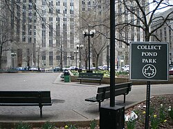
The park in 2008, facing East
The granite foundation of The Tombs uncovered during reconstruction of Collect Pond Park in early 2012 Collect pond park-reconstruction.jpg
The granite foundation of The Tombs uncovered during reconstruction of Collect Pond Park in early 2012

The park is located on the block bordered by Lafayette Street, Leonard Street, Centre Street, and White Street, [10] and sits between the three city courthouses: the Criminal Court, Civil Court, and Family Court. [10] [11]

In 1960, the New York City Board of Estimate transferred the former site of Collect Pond to the New York City Department of Parks and Recreation for conversion into a park. Originally named "Civil Court Park" because of its proximity to the surrounding courthouses, it was renamed "Collect Pond Park" under Commissioner Henry J. Stern to represent the location's history. [10]

In 2006, the city received funding for a renovation of Collect Pond Park, using federal-relief funds distributed after the September 11 attacks. [12] The park was closed for a total reconstruction in 2011. [13] The granite foundation of The Tombs was uncovered in 2012, leading to a partial stop-work order pending archaeological investigation. [14] The rebuilt park reopened in May 2014, with a pool evocative of the former Collect Pond. [15] The project had cost $4.6 million. Although the park was popular among residents and visitors, the pool had to be drained and repaired within months of the park's reopening; [16] it was refilled in 2015. [17]

It is still possible to ascertain the rough boundaries of Collect Pond and original topography in the elevations of the streets in the area, with the lowest elevation being Centre Street which runs in the approximate center of the former pond. [18]

In 2020, the Italian-Argentine sculptor Luciano Garbati's work Medusa With the Head of Perseus (2008), a seven-foot-tall representation of Medusa carrying Perseus's head, was installed in the center of the park as part of the NYC Parks Department's public art program. Garbati's work, a reversal of Cellini's Perseus with the Head of Medusa , an Italian Renaissance bronze, was reimagined by MeToo movement advocates as a symbol of feminist triumph. [19]

Related Research Articles

<span class="mw-page-title-main">Five Points, Manhattan</span> Neighborhood of Manhattan in New York City

Five Points was a 19th-century neighborhood in Lower Manhattan, New York City. The neighborhood, partly built on low-lying land which had filled in the freshwater lake known as the Collect Pond, was generally defined as being bound by Centre Street to the west, the Bowery to the east, Canal Street to the north, and Park Row to the south. The Five Points gained international notoriety as a densely populated, disease-ridden, crime-infested slum which existed for over 70 years.

<span class="mw-page-title-main">SoHo, Manhattan</span> Neighborhood in Manhattan, New York

SoHo, sometimes written Soho, is a neighborhood in Lower Manhattan, New York City. Since the 1970s, the neighborhood has been the location of many artists' lofts and art galleries, and has also been known for its variety of shops ranging from trendy upscale boutiques to national and international chain store outlets. The area's history is an archetypal example of inner-city regeneration and gentrification, encompassing socioeconomic, cultural, political, and architectural developments.

<span class="mw-page-title-main">Wayne Township, Erie County, Pennsylvania</span> Township in Pennsylvania, United States

Wayne Township is a township in Erie County, Pennsylvania, United States. The population was 1,539 at the 2020 census, down from 1,659 at the 2010 census, down from 1,766 in 2000.

<span class="mw-page-title-main">South Street Seaport</span> United States historic place

The South Street Seaport is a historic area in the New York City borough of Manhattan, centered where Fulton Street meets the East River, within the Financial District of Lower Manhattan. The Seaport is a designated historic district. It is part of Manhattan Community Board 1 in Lower Manhattan, and is next to the East River to the southeast and the Two Bridges neighborhood to the northeast.

<span class="mw-page-title-main">Canal Street (Manhattan)</span> Street in Manhattan, New York

Canal Street is a major east–west street of over 1 mile (1.6 km) in Lower Manhattan, New York City, United States, running from East Broadway between Essex and Jefferson Streets in the east, to West Street between Watts and Spring Streets in the west. It runs through the neighborhood of Chinatown, and forms the southern boundaries of SoHo and Little Italy as well as the northern boundary of Tribeca. The street acts as a major connector between Jersey City, New Jersey, via the Holland Tunnel (I-78), and Brooklyn in New York City via the Manhattan Bridge. It is a two-way street for most of its length, with two unidirectional stretches between Forsyth Street and the Manhattan Bridge.

<span class="mw-page-title-main">Mulberry Street (Manhattan)</span> Street in Manhattan, New York

Mulberry Street is a principal thoroughfare in Lower Manhattan, New York City, United States. It is historically associated with Italian-American culture and history, and in the late 19th and early 20th centuries was the heart of Manhattan's Little Italy.

<span class="mw-page-title-main">Foley Square</span> Street intersection in Manhattan, New York

Foley Square, also called Federal Plaza, is a street intersection in the Civic Center neighborhood of Lower Manhattan, New York City, which contains a small triangular park named Thomas Paine Park. The space is bordered by Worth Street to the north, Centre Street to the east, and Lafayette Street to the west, and is located south of Manhattan's Chinatown and east of Tribeca. It was named after a prominent Tammany Hall district leader and local saloon owner, Thomas F. "Big Tom" Foley (1852–1925).

<span class="mw-page-title-main">Fulton Street (Manhattan)</span> Street in Manhattan, New York

Fulton Street is a busy street located in Lower Manhattan in New York City. Located in the Financial District, a few blocks north of Wall Street, it runs from West Street at the site of the World Trade Center to South Street, terminating in front of the South Street Seaport. The westernmost two blocks and the easternmost block are pedestrian streets.

<span class="mw-page-title-main">The Tombs</span> Detention complex in Manhattan, New York

The Tombs was the colloquial name for Manhattan Detention Complex, a former municipal jail at 125 White Street in Lower Manhattan, New York City. It was also the nickname for three previous city-run jails in the former Five Points neighborhood of lower Manhattan, in an area now known as the Civic Center.

<span class="mw-page-title-main">Civic Center, Manhattan</span> Neighborhood of Manhattan in New York City

The Civic Center is an area and neighborhood in Lower Manhattan, Manhattan, New York City, that encompasses New York City Hall, One Police Plaza, the courthouses in Foley Square, the Metropolitan Correctional Center, and the surrounding area. The district is bound on the west by Tribeca at Broadway, on the north by Chinatown at Worth Street or Bayard Street, on the east by the East River and the Brooklyn Bridge at South Street, and on the south by the Financial District at Ann Street.

<span class="mw-page-title-main">South Street (Manhattan)</span> Street in Manhattan, New York

South Street is a street in Lower Manhattan, New York City, located immediately adjacent to the East River. It runs from Whitehall Street near the southern tip of Manhattan to Jackson Street near the Williamsburg Bridge. An elevated portion of FDR Drive, known as the South Street Viaduct, runs along the entire length of the street.

<span class="mw-page-title-main">Centre Street (Manhattan)</span> Street in Manhattan, New York

Centre Street is a north–south street in the New York City borough of Manhattan, running through the Civic Center, Chinatown, and Little Italy neighborhoods of Lower Manhattan. It connects Park Row to the south with Spring Street to the north, where it merges with Lafayette Street. Centre Street carries northbound traffic north of Reade Street and two-way traffic between Reade Street and the Brooklyn Bridge.

<span class="mw-page-title-main">Grand Street (Manhattan)</span> Street in Manhattan, New York

Grand Street is a street in Lower Manhattan, New York City. It runs west/east parallel to and south of Delancey Street, from SoHo through Chinatown, Little Italy, the Bowery, and the Lower East Side. The street's western terminus is Varick Street, and on the east it ends at the service road for the FDR Drive.

<span class="mw-page-title-main">West Broadway</span> Street in Manhattan, New York

West Broadway is a north-south street in the New York City borough of Manhattan, separated into two parts by Tribeca Park. The northern part begins at Tribeca Park, near the intersection of Avenue of the Americas, Walker Street and Beach Street in Tribeca. It runs northbound as a one-way street past Canal Street and becomes two-way at the intersection with Grand Street one block farther north. West Broadway then operates as a main north-south thoroughfare through SoHo until its northern end at Houston Street, on the border between SoHo and Greenwich Village. North of Houston Street, it is designated as LaGuardia Place, which continues until Washington Square South.

<span class="mw-page-title-main">Greenwich Street</span> Street in Manhattan, New York

Greenwich Street is a north–south street in the New York City borough of Manhattan. It extends from the intersection of Ninth Avenue and Gansevoort Street in the Meatpacking District at its northernmost end to its southern end at Battery Park. Greenwich Street runs through the Meatpacking District, the West Village, Hudson Square, and Tribeca.

<span class="mw-page-title-main">Church Street and Trinity Place</span> North-south street in Manhattan, New York

Church Street and Trinity Place form a single northbound roadway in Lower Manhattan, New York City. Its northern end is at Canal Street and its southern end is at Morris Street, where Trinity Place merges with Greenwich Street. The dividing point is Liberty Street.

<span class="mw-page-title-main">Duane Park</span> Public park in Manhattan, New York

Duane Park is a small, triangular public urban park located in the diamond of the Tribeca neighborhood of Manhattan, New York City. The park is bordered by Hudson Street to the east and branches of Duane Street on north and south sides. It was originally laid out by Calvert Vaux.

<span class="mw-page-title-main">Minetta Creek</span> Buried stream in Manhattan, New York

Minetta Creek was one of the largest natural watercourses in Manhattan, New York City, United States. Minetta Creek was fed from two tributaries, one originating at Fifth Avenue and 21st Street, and the other originating at Sixth Avenue and 16th Street. They joined near Fifth Avenue and 11th Street then took a southwesterly course. Minetta Creek's name is thought to have originated from either the Native American term "Manette", meaning "Devil's Water", or the Dutch word "Minnetje", meaning "the little one".

<span class="mw-page-title-main">West Street pedestrian bridges</span> Bridges in Manhattan, New York

The West Street pedestrian bridges are a series of pedestrian bridges that cross West Street to connect the neighborhoods of Tribeca and the Financial District with Battery Park City in Lower Manhattan, New York City. The bridges were built to provide alternatives to crossing the busy street. Prior to the September 11 attacks, there were three bridges at Chambers Street, Vesey Street and Liberty Street. The Vesey Street and Liberty Street bridges connected the former World Trade Center complex with the World Financial Center.

<span class="mw-page-title-main">Elizabeth H. Berger Plaza</span> Plaza in Manhattan, New York

Elizabeth H. Berger Plaza is a public park in the Financial District of Manhattan, New York City. formed by the triangular junction of Trinity Place, Greenwich Street and Edgar Street. It faces the Manhattan exit ramp from the Brooklyn–Battery Tunnel. Formerly known as the Edgar Street Greenstreet, this park honors civic advocate Elizabeth H. Berger (1960-2013). In her role as president of the Downtown Alliance, she advocated for the fusion of two traffic triangles at this location into an expanded park. The park is located on the site of a former neighborhood known as Little Syria, a bustling immigrant community displaced by the construction of the tunnel in 1953.

References

  1. 1 2 3 4 Jackson, Kenneth T., ed. (1995). The Encyclopedia of New York City . New Haven: Yale University Press. ISBN   0300055366., p. 250.
  2. Richardson, James (1970). Encyclopedia of New York City. New York: Oxford University Press.
  3. Burrows, E. G., Wellace, M. (1998). "Chapter 23: The Road to City Hall". Gotham: A History of New York City to 1898. Oxford University Press. ISBN   978-0-19-511634-2.
  4. "The Hudson: A History" Tom Lewis (2007).
  5. "Abattoirs.; History of New-York Slaughter-Houses-Interesting and Curious Data. (1866)". The New York Times .
  6. "Craftsmen In Clay" @ www.corzilius.org
  7. Scientific American, New Series, Volume 3, Issue 8, page 116. August 18, 1860
  8. Kieran, John. A Natural History of New York. p. 31. ISBN   978-0-8232-1086-2.
  9. Delaney, Tim. American Street Gangs. pp. 39, 290.
  10. 1 2 3 Collect Pond Park, New York City Department of Parks and Recreation. Accessed April 19, 2024.
  11. Donna Ferrato, Dare to Survive, New York Times (January 2, 2023).
  12. Collins, Glenn (February 9, 2006). "6 Lower Manhattan Public Spaces to Bloom With Post-9/11 Funds". The New York Times. Retrieved April 19, 2024.
  13. Shapiro, Julie (July 22, 2011). "City Puts the Pond Back in Collect Pond Park". DNAinfo New York. Retrieved April 19, 2024.
  14. Hogarty, Dave (August 9, 2012). "Old Tombs Excavated at Collect Pond Park Construction". Curbed NY. Retrieved April 19, 2024.
  15. "Bigger! Better! The New Collect Pond Park Is Open". Tribeca Citizen. May 22, 2014. Retrieved April 19, 2024.
  16. Glassman, Carl (August 4, 2014). "New Collect Pond Park, Popular But Still Beset with Problems". Tribeca Trib Online. Retrieved April 19, 2024.
  17. Glassman, Carl (July 26, 2015). "Collect Pond Park Finally Gets Its 'Pond' Water Back". Tribeca Trib Online. Retrieved April 19, 2024.
  18. Kadinsky, Sergey (2016). Hidden Waters of New York City: A History and Guide to 101 Forgotten Lakes, Ponds, Creeks, and Streams in the Five Boroughs. New York, NY: Countryman Press. pp. 1–9. ISBN   978-1-58157-566-8.
  19. Julia Jacobs, How a Medusa Sculpture From a Decade Ago Became #MeToo Art, New York Times (October 13, 2020).

40°42′59″N74°00′06″W / 40.71639°N 74.00167°W / 40.71639; -74.00167