
The East Coast Greenway is a 3,000-mile (4,800 km) pedestrian and bicycle route between Maine and Florida along the East Coast of the United States. The nonprofit East Coast Greenway Alliance was created in 1991 with the goal to use the entire route with off-road, shared-use paths; as of 2021, over 1,000 mi (1,600 km) of the route (35%) meets this criteria. In 2020, the Greenway received over 50 million visits.

The Bronx River, is a river that is approximately 24 miles (39 km) long, and flows through southeastern New York in the United States and drains an area of 38.4 square miles (99 km2). It is named after colonial settler Jonas Bronck. Besides the Hutchinson River, the Bronx River is the only fresh water river in New York City.
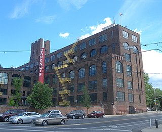
Hunts Point is a neighborhood located on a peninsula in the South Bronx of New York City. It is the location of one of the largest food distribution facilities in the world, the Hunts Point Cooperative Market. Its boundaries are the Bruckner Expressway to the west and north, the Bronx River to the east, and the East River to the south. Hunts Point Avenue is the primary street through Hunts Point.

Riverside South is an urban development project in the Lincoln Square neighborhood of the Upper West Side of Manhattan, New York City. It was originated by six civic associations – The Municipal Art Society, Natural Resources Defense Council, New Yorkers for Parks, Regional Plan Association, Riverside Park Fund, and Westpride – in partnership with real estate developer Donald Trump. The largely residential complex, located on the site of a former New York Central Railroad yard, includes Freedom Place and Riverside Center. The $3 billion project is on 57 acres (23 ha) of land along the Hudson River between 59th Street and 72nd Street.

New York State Route 895 (NY 895), known locally as Sheridan Boulevard, is an urban boulevard in the New York City borough of The Bronx. Its south end is at a merge with the Bruckner Expressway (I-278) in the Hunts Point neighborhood, and its north end is at the Cross Bronx Expressway (I-95), where the road connects with local streets in the West Farms neighborhood.

Adolfo Carrión Jr. is an American businessman and former elected official from City Island. He has three sisters Elizabeth Carrión-Stevens, Damaris Carrión-Harris and Lizette Carrión. He served one term as a member of the New York City Council, representing the 14th district. He served for seven years as the borough president of the Bronx, for a year and five months as the first director of the White House Office of Urban Affairs in the Obama administration, and then for nearly two years as Regional Administrator for HUD's New York and New Jersey Regional Office. He left HUD in February 2012.

Joseph Patrick Riley Jr. is an American politician who was the Mayor of Charleston, South Carolina. He was one of the longest serving mayors in the United States that is still living, having served 10 terms starting on December 15, 1975, and ending on January 11, 2016.

Fort Washington Park is a public park located in the Washington Heights section of Upper Manhattan in New York City. It runs along the banks of the Hudson River next to Riverside Drive and the Henry Hudson Parkway from West 155th Street to Dyckman Street. The George Washington Bridge crosses above the park; below the bridge is a small point of land called Jeffrey's Hook, which is the site of the Little Red Lighthouse.

Majora Carter is an American urban revitalization strategist and public radio host from the South Bronx area of New York City. Carter founded and led the non-profit environmental justice solutions corporation Sustainable South Bronx from 2001 onward, before entering the private sector in 2008.

The Manhattan Waterfront Greenway is a waterfront greenway for walking or cycling, 32 miles (51 km) long, around the island of Manhattan, in New York City. The largest portions are operated by the New York City Department of Parks and Recreation. It is separated from motor traffic, and many sections also separate pedestrians from cyclists. There are three principal parts — the East, Harlem and Hudson River Greenways.

Columbia Point, in the Dorchester neighborhood of Boston, Massachusetts, sits on a peninsula jutting out from the mainland of eastern Dorchester into the bay. Old Harbor Park is on the north side, adjacent to Old Harbor, part of Dorchester Bay. The peninsula is primarily occupied by Harbor Point, the University of Massachusetts Boston, the John F. Kennedy Presidential Library and Museum, the Edward M. Kennedy Institute for the United States Senate, and a complex at the former Bayside Expo Center, Boston College High School, and the Massachusetts Archives. The Boston Harborwalk follows the entire coastline.

Washington Market Park is an urban park located in the TriBeCa neighborhood of Lower Manhattan in New York City. The park, which is bounded by Greenwich, Chambers, and West Streets, covers 1.61-acre (6,500 m2). The park also has community gardens and a large playground and hosts many community events.

The East River Greenway is an approximately 9.44-mile-long (15.19 km) foreshoreway for walking or cycling on the east side of the island of Manhattan on the East River. It is part of the Manhattan Waterfront Greenway. The largest portions are operated by the New York City Department of Parks and Recreation. It is separated from motor traffic, and many sections also separate pedestrians from cyclists. The greenway is parallel to the Franklin D. Roosevelt East River Drive for a majority of its length.

Soundview Park is a 205-acre (83 ha) park on Clason Point in the southern portion of the Bronx, New York City. The park is adjacent to the Clason Point, Hunts Point, and Soundview neighborhoods, situated where the Bronx River flows into the East River, roughly opposite Rikers Island and LaGuardia Airport. The park is bounded by the Bronx River Estuary/East River, Lafayette Avenue, Morrison Avenue, Story Avenue, Metcalf Avenue, O'Brien Avenue, and Bronx River Avenue.

The New York City FC stadium is a proposed soccer-specific stadium to be built in Willets Point in the New York City borough of Queens for New York City FC of Major League Soccer, who currently play home games at Yankee Stadium. The stadium is scheduled to be completed in 2027.
The Rudy Bruner Award for Urban Excellence (RBA) was established in 1986 by Cambridge, Massachusetts architect Simeon Bruner. The award is named after Simeon Bruner's late father, Rudy Bruner, founder of the Bruner Foundation. According to the Bruner Foundation, the RBA was created to increase understanding of the role of architecture in the urban environment and promote discussion of what constitutes urban excellence. The award seeks to identify and honor places, rather than people, that address economic and social concerns along with urban design.
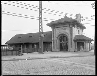
The Westchester Avenue station is a former railroad station located in the Bronx in New York City, partially suspended over Amtrak's busy Northeast Corridor line. It was built in 1908 with rich terra cotta detailing to a design by Cass Gilbert, who would later employ similar terra cotta detailing in his 1910 design for the Woolworth Building. Train service to the station ceased in 1937, and as of 2022 the station was a ruin in poor condition.

The POINT Community Development Corporation is a non-profit community development corporation dedicated to youth development, culture, and the economic revitalization of the Hunts Point neighborhood of the South Bronx, from which it takes its name. The mission of The POINT CDC is to encourage the arts, local enterprise, responsible ecology, and self-investment in the Hunts Point community. The organization was founded in 1993 by Steven Sapp, Maria Torres, Paul Lipson, and Mildred Ruiz-Sapp.


