
The Rockaway Peninsula, commonly referred to as The Rockaways or Rockaway, is a peninsula at the southern edge of the New York City borough of Queens on Long Island, New York. Relatively isolated from Manhattan and other more urban parts of the city, Rockaway became a popular summer retreat in the 1830s. It has since become a mixture of lower, middle, and upper-class neighborhoods. In the 2010s, it became one of the city's most quickly gentrifying areas.

Rockaway Beach is a neighborhood on the Rockaway Peninsula in the New York City borough of Queens. The neighborhood is bounded by Arverne to the east and Rockaway Park to the west. It is named for the Rockaway Beach and Boardwalk, which is the largest urban beach in the United States, stretching from Beach 3rd to Beach 153rd Streets on the Atlantic Ocean. The neighborhood, with 13,000 residents as of 2010, is also known as the "Irish Riviera" because of its large Irish American population.
Belle Harbor is a small residential neighborhood in the New York City borough of Queens, located on the western half of the Rockaway Peninsula, the southernmost area of the borough. Belle Harbor commonly refers to the area from Beach 126th to Beach 141st Streets.

Arverne is a neighborhood in the New York City borough of Queens, on the Rockaway Peninsula. It was initially developed by Remington Vernam, whose signature "R. Vernam" inspired the name of the neighborhood. Arverne extends from Beach 54th Street to Beach 79th Street, along its main thoroughfare Beach Channel Drive, alternatively known as Rev. Joseph H. May Drive.

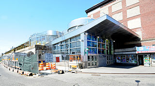
The Rockaway Park–Beach 116th Street station is the western terminal station on the IND Rockaway Line of the New York City Subway, located on Beach 116th Street near Rockaway Beach Boulevard in Rockaway Beach, Queens. It is served by the Rockaway Park Shuttle at all times and ten daily rush-hour A trains in the peak direction.
The Far Rockaway–Mott Avenue station is the eastern terminal station of the New York City Subway's IND Rockaway Line. Originally a Long Island Rail Road station, it is currently the easternmost station in the New York City Subway. It is served by the A train at all times.
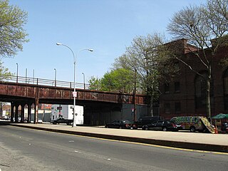
The IND Rockaway Line is a rapid transit line of the IND Division of the New York City Subway, operating in Queens. It branches from the IND Fulton Street Line at Rockaway Boulevard, extending over the Jamaica Bay, into the Rockaways. The A train serves the line on the Far Rockaway–Mott Avenue branch and north of Hammels Wye. The Rockaway Park Shuttle runs between Broad Channel and Rockaway Park–Beach 116th Street. Five rush hour A trains provide service between Rockaway Park and Manhattan in the peak direction.

Jacob Riis Park, also called Jacob A. Riis Park and Riis Park, is a seaside park on the southwestern portion of the Rockaway Peninsula in the New York City borough of Queens. It lies at the foot of the Marine Parkway–Gil Hodges Memorial Bridge, east of Fort Tilden, and west of Neponsit and Rockaway Beach. Originally run by the New York City Department of Parks and Recreation, it is now part of the Jamaica Bay Unit of the Gateway National Recreation Area, and is managed by the National Park Service (NPS). It features an extensive sand beach along the Atlantic Ocean coastline and several historic Art Deco structures.

Shore Front Parkway is a 2.5-mile (4.0 km) beachfront road paralleling the Rockaway Beach and Boardwalk in the New York City borough of Queens, running between Beach 73rd Street and Beach 108th Street.
The Rockaway Beach Branch was a rail line owned and operated by the Long Island Rail Road in Queens, New York City, United States. The line left the Main Line at Whitepot Junction in Rego Park heading south via Ozone Park and across Jamaica Bay to Hammels in the Rockaways, turning west there to a terminal at Rockaway Park. Along the way it connected with the Montauk Branch near Glendale, the Atlantic Branch near Woodhaven, and the Far Rockaway Branch at Hammels.

The Riegelmann Boardwalk is a 2.7-mile-long (4.3 km) boardwalk along the southern shore of the Coney Island peninsula in the New York City borough of Brooklyn, facing the Atlantic Ocean. Opened in 1923, the boardwalk runs between West 37th Street at the edge of the Sea Gate neighborhood to the west and Brighton 15th Street in Brighton Beach to the east. It is operated by the New York City Department of Parks and Recreation.

The South Beach–Franklin Delano Roosevelt Boardwalk, alternately referred to as the FDR Boardwalk or the South Beach Boardwalk, is a boardwalk facing the Lower New York Bay on the East Shore of Staten Island, one of the five boroughs of New York City. The boardwalk is the main feature of a public park that stretches from Fort Wadsworth and the Verrazzano-Narrows Bridge to Miller Field, both part of the Gateway National Recreation Area. The park also contains numerous recreational facilities, including a skate park.

SITE Design Group is a consulting firm specializing in landscape architecture, urban planning and skateparks. Based in Solana Beach, California, the firm operates worldwide and has overseen the creation of over 100 parks.

Far Rockaway Beach Bungalow Historic District is a historic area in Far Rockaway, Queens County, New York. It includes summer beach bungalows near the oceanfront of Far Rockaway. They are smaller than the usual domestic bungalows of the 1920s. They were built in 1921 using pattern book designs incorporating uniform facades, compact interiors, integrated porches and exposed rafters. Their architect, Henry Hohauser, became better known in the 1930s as a designer of Art Deco hotels in Miami Beach. The district was hit by Hurricane Sandy in 2012, but survived without major damage. The district is located along Beach 24th, 25th, and 26th Streets. It was listed on the National Register of Historic Places in 2013.
O'Donohue Park is a public green space located in the Far Rockaway neighborhood on the Rockaway Peninsula of Queens in New York City. The park is located at the eastern tip of the Rockaway Beach and Boardwalk.
A list of skateparks in New York City.

Millennium Skate Park, also known as Owl's Head Skate Park, is a skate park in Bay Ridge, Brooklyn, located in Owl's Head Park, adjacent to the Sunset Park Greenway.

The Rockaway Beach and Boardwalk is a public park in Rockaway, Queens, New York, composed of the 170-acre (69 ha) Rockaway Beach and the adjacent 5.5-mile (8.9 km) Rockaway Boardwalk. The beach runs from Beach 9th Street in Far Rockaway to Beach 149th Street in Neponsit, a distance of 7 miles (11 km). The boardwalk, a concrete deck, runs from Beach 9th Street to Beach 126th Street in Rockaway Park, at the edge of Belle Harbor. There are also numerous recreational facilities within the park, parallel to the beach and boardwalk.


