Related Research Articles

Ozone Park is a neighborhood in the southwestern section of the New York City borough of Queens, New York, United States. It is next to the Aqueduct Racetrack in South Ozone Park, a popular spot for Thoroughbred racing and home to the Resorts World Casino & Hotel. A diverse neighborhood known for its large Italian-American population, Ozone Park has become a more diverse community made up of Caribbean, Hispanic, and East/South Asian residents.

Bensonhurst is a residential neighborhood in the southwestern section of the New York City borough of Brooklyn. The neighborhood is bordered on the northwest by 14th Avenue, on the northeast by 60th Street, on the southeast by Avenue P and 22nd Avenue, and on the southwest by 86th Street. It is adjacent to the neighborhoods of Dyker Heights to the northwest, Borough Park and Mapleton to the northeast, Bath Beach to the southwest, and Gravesend to the southeast.
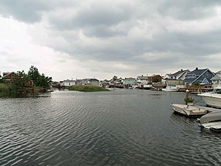
Howard Beach is a neighborhood in the southwestern portion of the New York City borough of Queens. It is bordered to the north by the Belt Parkway and Conduit Avenue in Ozone Park, to the south by Jamaica Bay in Broad Channel, to the east by 102nd–104th Streets in South Ozone Park, and to the west by 75th Street in East New York, Brooklyn. The area consists mostly of low-rise single-family houses.

Bath Beach is a neighborhood in Brooklyn, New York City, United States. It is located at the southwestern edge of the borough on Gravesend Bay. The neighborhood borders Bensonhurst and New Utrecht to the northeast across 86th Street; Dyker Beach Park and Golf Course to the northwest across 14th Avenue; and Gravesend to the east across Stillwell Avenue.

Dante Park is a public park in Manhattan, New York City, located in the Upper West Side neighborhood in front of Lincoln Center near Central Park.

Cooper Square is a junction of streets in Lower Manhattan, New York City located at the confluence of the neighborhoods of Bowery to the south, NoHo to the west and southwest, Greenwich Village to the west and northwest, the East Village to the north and east, and the Lower East Side to the southeast.

Mitchel Square Park is a small urban park in the Washington Heights neighborhood of the New York City borough of Manhattan. It is a two part, triangle-shaped park formed by the intersection of Saint Nicholas Avenue, Broadway and 167th Street.
Lieutenant Joseph Petrosino Square is small triangular park in lower Manhattan in New York City, bounded by Cleveland Place and Lafayette and Kenmare Streets, two blocks north of the old police headquarters at 240 Centre Street, at the juncture of the Little Italy, Nolita, and SoHo neighborhoods. Formerly Kenmare Square, it changed its name in 1987 in honor of Lieutenant Joseph Petrosino, an early 20th century NYPD official dedicated to investigating and combating, among other adversaries, the Black Hand, an early version of the Mafia in America.
Alben Square, also known as Alben Triangle, is located in the Borough Park neighborhood of Brooklyn, New York.
Ascenzi Square is a small plaza formed by the intersection of two street grids that meet at Metropolitan Avenue in the Williamsburg neighborhood of Brooklyn, New York City. Roebling Street traverses both grids, making a slight jog to the southwest between North Fourth Street and Metropolitan Avenue. On March 29, 1939, the New York City Council designated this triangle as Ascenzi Square, in honor of brothers Joseph and William Ascenzi, residents of Williamsburg who were killed in the First World War.
Travis Triangle is a narrow green space in the Murray Hill/Flushing neighborhoods of Queens, New York City. It is formed by the separation of Murray Street and Murray Lane, both of which were named after the Murray family, which owned land on the site of these streets from the late colonial period through the early 19th century. In 1932, New York City's Board of Aldermen passed a resolution to name this site Travis Triangle in honor of local American Civil War veteran Ira Underhill Travis (1839-1921), who fought under the name Ira Wilson, in the 11th New York Volunteer Infantry Regiment also known as Colonel Elmer E. Ellsworth’s Zouaves.
McKenna Square is a 0.24-acre public green space in the Washington Heights neighborhood of Upper Manhattan in New York City. The park is located in a median of West 165th Street, between Audubon and Amsterdam Avenues. The triangular site was created in 1917 in conjunction of the widening of West 165th Street and was transferred to Parks in 1937.

Triangle 54 is a 8,973.36-square-foot (833.652 m2) public park located in the Blissville neighborhood of Long Island City in Queens, New York City. This traffic triangle is bound by 48th Street on the southwest and east, and 54th Avenue on the north. The park contains ten trees and a memorial flagstaff in its center that dates to 1930. On its granite base is inscribed, "Erected by the citizens of Laurel Hill in memory of those who died in the World War." Laurel Hill is an old name for this area, which once had its own railroad station. The name still appears on the map in Laurel Hill Boulevard, which runs a few blocks to the north of this site.
Walter J. Wetzel Triangle is small park bound by Cohancy Street, 156th Avenue, 99th Street, and 157th Avenue, in the Howard Beach neighborhood of Queens, New York City.
Chris Postiglione Triangle is a green space in the Fresh Meadows neighborhood of Queens, New York City, formed by the separation of the eastbound Horace Harding Expressway, 64th Avenue, and 174th Street. Its namesake, Christopher S. Postiglione (1968-1999), a construction worker at the New York City Department of Environmental Protection, who grew up in Queens.

Macri Triangle is a 0.57 acres park located at the intersection of Meeker Avenue, Union Avenue, and Metropolitan Avenue in Williamsburg, Brooklyn, New York City. The property was designated as a park in 1946 during the construction of the Brooklyn-Queens Expressway, which resulted in the demolition of buildings along its route and the extension of Meeker Avenue from Richardson Street south to Metropolitan Avenue, serving as the expressway's service road. As the highway ran through the street grid, triangular parcels that were too small to be developed were designated as public plazas, including this one.

The Remsen Cemetery is a private burial ground in Queens, New York City, at 69-43 Trotting Course Lane on the border of the Middle Village and Rego Park neighborhoods. The cemetery is on a 2.5-acre (1.0 ha) triangle just north of Metropolitan Avenue and one block east of Woodhaven Boulevard. The Remsen Cemetery contains the remains of members of the Remsen family who died between 1790 and the early 19th century. The burials in the cemetery include that of American Revolutionary War colonel Jeromus Remsen (1735–1790), as well as his wife, his brother, and four of his children. The remains of an eighth person, Bridget Remsen, are also in the cemetery.
References
- ↑ Miller, Adam (November 10, 2000). "B'klyn Hero's Family Happy to See Stolen Memorial Replaced". New York Post. Retrieved January 30, 2022.