
The Rockaway Peninsula, commonly referred to as The Rockaways or Rockaway, is a peninsula at the southern edge of the New York City borough of Queens on Long Island, New York. Relatively isolated from Manhattan and other more urban parts of the city, Rockaway became a popular summer retreat in the 1830s. It has since become a mixture of lower, middle, and upper-class neighborhoods. In the 2010s, it became one of the city's most quickly gentrifying areas.

Rockaway Beach is a neighborhood on the Rockaway Peninsula in the New York City borough of Queens. The neighborhood is bounded by Arverne to the east and Rockaway Park to the west. It is named for the Rockaway Beach and Boardwalk, which is the largest urban beach in the United States, stretching from Beach 3rd to Beach 153rd Streets on the Atlantic Ocean. The neighborhood, with 13,000 residents as of 2010, is also known as the "Irish Riviera" because of its large Irish American population.

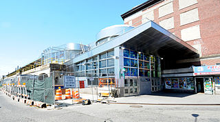
The Howard Beach–JFK Airport station is a subway/people mover station complex located at Coleman Square between 159th Avenue and 103rd Street in Howard Beach, Queens. The New York City Subway portion of the station is on the IND Rockaway Line and is served by the Rockaway branch of the A train at all times and the Rockaway Park Shuttle on summer weekends, and the AirTrain JFK portion of the station complex is served by the AirTrain's Howard Beach branch at all times.

The Far Rockaway Branch is an electrified rail line and service owned and operated by the Long Island Rail Road in the U.S. state of New York. The branch begins at Valley Interlocking, just east of Valley Stream station. From Valley Stream, the line heads south and southwest through southwestern Nassau County, ending at Far Rockaway in Queens, thus reentering New York City. LIRR maps and schedules indicate that the Far Rockaway Branch service continues west along the Atlantic Branch to Jamaica. This two-track branch provides all day service in both directions to the Atlantic Terminal in Brooklyn, with limited weekday peak service to/from Penn Station in Midtown Manhattan. During peak hours, express service may bypass Jamaica station.

Arverne is a neighborhood in the New York City borough of Queens, on the Rockaway Peninsula. It was initially developed by Remington Vernam, whose signature "R. Vernam" inspired the name of the neighborhood. Arverne extends from Beach 54th Street to Beach 79th Street, along its main thoroughfare Beach Channel Drive, alternatively known as Rev. Joseph H. May Drive.

The Beach 105th Street station is a station on the IND Rockaway Line of the New York City Subway, located at Beach 105th Street on the Rockaway Freeway in Queens. It is served by the Rockaway Park Shuttle at all times and ten daily rush-hour only A trains.

The Beach 67th Street station is a station on the IND Rockaway Line of the New York City Subway. Located at Beach 67th Street and Rockaway Freeway in Arverne, Queens, it is served by the A train at all times. The station is adjacent to Kohlreiter Square, a public green space on the north side of the station.

The Beach 60th Street station is a station on the IND Rockaway Line of the New York City Subway. Located in Queens on the Rockaway Freeway at Beach 60th Street, it is served by the A train at all times.

The Beach 36th Street station is a station on the IND Rockaway Line of the New York City Subway. The station is located at the intersection of Beach 36th Street and Rockaway Freeway in Edgemere, Queens. It is served by the A train at all times.

The Beach 25th Street station is a station on the IND Rockaway Line of the New York City Subway, located in Queens on the Rockaway Freeway at Beach 25th Street. It is served by the A train at all times. There are two tracks and two side platforms.
The Far Rockaway–Mott Avenue station is the eastern terminal station of the New York City Subway's IND Rockaway Line. Originally a Long Island Rail Road station, it is currently the easternmost station in the New York City Subway. It is served by the A train at all times.

Rockaway Park is a neighborhood in the New York City borough of Queens. The area is on the Rockaway Peninsula, nestled between Jamaica Bay to the north and the Atlantic Ocean to the south. The neighborhood of Rockaway Beach lies on its eastern border while the community of Belle Harbor is situated on its western side. The neighborhood is part of Queens Community Board 14.

Hammels is an area within Rockaway Beach on the Rockaway Peninsula in the New York City borough of Queens. It is located west of Arverne and east of Seaside, and is centered on Beach 84th Street. Its main thoroughfare is Beach Channel Drive. The New York City Subway's A train travels through the neighborhood on the IND Rockaway Line. The Hammel Houses, a public housing project built in 1954, is located in the neighborhood.

Rockaway Beach Boulevard, opened in 1886, was the first major east-west thoroughfare on the Rockaway Peninsula in the Borough of Queens in New York City. Much of its route parallels the Rockaway Freeway and the IND Rockaway Line above the Freeway. The boulevard first forks off at its eastern end from Beach Channel Drive at Beach 35th Street in Edgemere and merges once again with Beach Channel Drive by Jacob Riis Park shortly before the Marine Parkway–Gil Hodges Memorial Bridge.
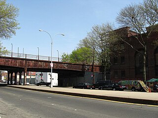
The Rockaway Freeway is a road in the New York City borough of Queens that was created from the old right-of-way of the Long Island Rail Road Rockaway Division in 1941–1942 as part of the project to eliminate grade crossings within New York City. The railroad line itself was elevated over the new automotive route, and was incorporated into the New York City Subway system as the IND Rockaway Line in June 1956.
The Rockaway Beach Branch was a rail line owned and operated by the Long Island Rail Road in Queens, New York City, United States. The line left the Main Line at Whitepot Junction in Rego Park heading south via Ozone Park and across Jamaica Bay to Hammels in the Rockaways, turning west there to a terminal at Rockaway Park. Along the way it connected with the Montauk Branch near Glendale, the Atlantic Branch near Woodhaven, and the Far Rockaway Branch at Hammels.
The Ocean Electric Railway was a street car line that operated on The Rockaways. It ran parallel to parts of the Rockaway Beach Branch and Far Rockaway Branch of the Long Island Rail Road. The headquarters of the OER were at the Far Rockaway Long Island Rail Road station which was then located across Mott Avenue from the existing Far Rockaway–Mott Avenue subway station. The Office of Superintendent - Trolleys at that location managed all the LIRR's owned trolley operations.

Metropolitan Transportation: A Program for Action, also known as simply the Program for Action, the Grand Design, or the New Routes Program, was a proposal in the mid-1960s for a large expansion of mass transit in New York City, created under then-Mayor John Lindsay. Originally published on February 29, 1968, the Program for Action was one of the most ambitious expansion plans in the history of the New York City Subway. The plan called for 50 miles (80 km) of tracks to be constructed, and more than 80% of the new trackage was to be built in the borough of Queens. The $2.9 billion plan also called for improvements to other modes of mass transit, such as the present-day Long Island Rail Road and Metro-North Railroad commuter rail systems, and further integration between mass transit and the New York City-area airport system.

The Q11, Q21, Q52, and Q53 bus routes constitute a public transit corridor running along Woodhaven and Cross Bay Boulevards in Queens, New York City. The corridor extends primarily along the length of the two boulevards through "mainland" Queens, a distance of 6 miles (9.7 km) between Elmhurst and the Jamaica Bay shore in Howard Beach. The Q52 and Q53 buses, which provide Select Bus Service along the corridor, continue south across Jamaica Bay to the Rockaway peninsula, one of the few public transit options between the peninsula and the rest of the city.

The Rockaway Beach and Boardwalk is a public park in Rockaway, Queens, New York, composed of the 170-acre (69 ha) Rockaway Beach and the adjacent 5.5-mile (8.9 km) Rockaway Boardwalk. The beach runs from Beach 9th Street in Far Rockaway to Beach 149th Street in Neponsit, a distance of 7 miles (11 km). The boardwalk, a concrete deck, runs from Beach 9th Street to Beach 126th Street in Rockaway Park, at the edge of Belle Harbor. There are also numerous recreational facilities within the park, parallel to the beach and boardwalk.
