
The New York City Fire Department, officially the Fire Department of the City of New York (FDNY), is an American department of the government of New York City that provides fire protection services, technical rescue/special operations services, chemical, biological, radiological, nuclear and high-yield explosive/hazardous materials response services and emergency medical response services within the five boroughs of New York City.
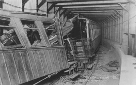
The Malbone Street wreck, also known as the Brighton Beach Line accident, was a rapid transit railroad accident that occurred on November 1, 1918, on the New York City Subway's BMT Brighton Line in the community of Flatbush in New York City's Brooklyn borough. A speeding train derailed in the sharply curved tunnel beneath Willink Plaza, the intersection of Flatbush Avenue, Ocean Avenue, and Malbone Street. At least 93 people died, making it one of the deadliest train crashes in North American history, as well as the deadliest crash in the history of the New York City Subway.

New York State Route 27 (NY 27) is a 120.58-mile (194.05 km) long state highway that runs east–west from Interstate 278 (I-278) in the New York City borough of Brooklyn to Montauk Point State Park on Long Island, New York. Its two most prominent components are Sunrise Highway and Montauk Highway, the latter of which includes the Montauk Point State Parkway. NY 27 acts as the primary east–west highway on southern Long Island east of the interchange with the Heckscher State Parkway in Islip Terrace. The entire route in Suffolk, Nassau, and Queens counties were designated by the New York State Senate as the POW/MIA Memorial Highway. The highway gives access to every town on the South Shore. NY 27 is the easternmost state route in the state of New York.

Triboro Coach Corporation was a bus company in New York City, United States, operating local service in Queens and express routes to Manhattan until February 20, 2006, when MTA Bus took over all of its bus operations and services.
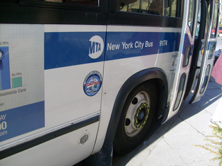
MTA Regional Bus Operations operates local and express buses serving New York City in the United States out of 29 bus depots. These depots are located in all five boroughs of the city, with the exception of one located in nearby Yonkers in Westchester County. 21 of these depots serve MTA New York City Transit (NYCT)'s bus operations, while the remaining eight serve the MTA Bus Company These facilities perform regular maintenance, cleaning, and painting of buses, as well as collection of revenue from bus fareboxes. Several of these depots were once car barns for streetcars, while others were built much later and have only served buses. Employees of the depots are represented by local divisions of the Transport Workers Union of America (TWU), particularly the TWU Local 100 and 101, or of the Amalgamated Transit Union (ATU)'s Local's 726 for all depots in Staten Island, 1056 for Casey Stengel, Jamaica, and Queens Village Depots, and 1179 for JFK & Far Rockaway Depots.
Wingate is a neighborhood in the north central portion of the New York City borough of Brooklyn. The area is bordered by Prospect Lefferts Gardens to the west, Crown Heights to the north and east, and East Flatbush to the south. Wingate is bounded by Empire Boulevard to the north, Troy Avenue to the east, Winthrop Street to the south, and New York Avenue to the west. The area is part of Brooklyn Community District 9. It is sometimes considered part of Crown Heights, East Flatbush, and/or Prospect Lefferts Gardens.

The South Beach–Franklin Delano Roosevelt Boardwalk, alternately referred to as the FDR Boardwalk or the South Beach Boardwalk, is a boardwalk facing the Lower New York Bay on the East Shore of Staten Island, one of the five boroughs of New York City. The boardwalk is the main feature of a public park that stretches from Fort Wadsworth and the Verrazzano-Narrows Bridge to Miller Field, both part of the Gateway National Recreation Area. The park also contains numerous recreational facilities, including a skate park.

Girls High School is a historically and architecturally notable public secondary school building located at 475 Nostrand Avenue in the Bedford–Stuyvesant neighborhood of Brooklyn, New York City. It was built in 1886.
Alben Square, also known as Alben Triangle, is located in the Borough Park neighborhood of Brooklyn, New York.

Ascenzi Square is a small plaza formed by the intersection of two street grids that meet at Metropolitan Avenue in the Williamsburg neighborhood of Brooklyn, New York City. Roebling Street traverses both grids, making a slight jog to the southwest between North Fourth Street and Metropolitan Avenue. On March 29, 1939, the New York City Council designated this triangle as Ascenzi Square, in honor of brothers Joseph and William Ascenzi, residents of Williamsburg who were killed in the First World War.
Anthony Catanzaro Square is located within a traffic triangle that is the result of three street grids that meet in the Bath Beach neighborhood of Brooklyn, New York. At this junction, West 16 Street meets its northern end at the same place where Avenue Y meets its western end, both of these roads meeting Bay 50th Street.
William M. Feehan Triangle is a 0.032-acre (130 m2) public green space in the Broadway-Flushing neighborhood of Queens, New York. It is bound by Bayside Lane, 164th Street, and 27th Avenue. The triangle’s shape is the result of the street grid imposed on the once-rural landscape of Flushing in the 1920s. Bayside Lane predates the grid, cutting across its numbered streets and avenues in a diagonal path. The park is landscaped with trees and shrubs. In 2002, the New York City Council passed legislation to name the triangle for William M. Feehan.
Bocchino-Dente Memorial Plaza is a 0.853-acre plaza located at the intersection of Fort Hamilton Parkway, 58th Street and 10th Avenue in the Borough Park section of Brooklyn, New York. The neighborhood's streets were laid out in a grid of streets and avenues at the turn of the 20th century while Fort Hamilton Parkway cuts diagonally through the grid on its route between Prospect Park and Bay Ridge. Triangular intersections that were too small to be developed were designated as public plazas, including this one. The plaza adjoins the school yard of Public School 105 The Blythebourne School, which carries the old name of Borough Park.

Triangle 54 is a 8,973.36-square-foot (833.652 m2) public park located in the Blissville neighborhood of Long Island City in Queens, New York City. This traffic triangle is bound by 48th Street on the southwest and east, and 54th Avenue on the north. The park contains ten trees and a memorial flagstaff in its center that dates to 1930. On its granite base is inscribed, "Erected by the citizens of Laurel Hill in memory of those who died in the World War." Laurel Hill is an old name for this area, which once had its own railroad station. The name still appears on the map in Laurel Hill Boulevard, which runs a few blocks to the north of this site.
Walter J. Wetzel Triangle is small park bound by Cohancy Street, 156th Avenue, 99th Street, and 157th Avenue, in the Howard Beach neighborhood of Queens, New York City.

Macri Triangle is a 0.57 acres park located at the intersection of Meeker Avenue, Union Avenue, and Metropolitan Avenue in Williamsburg, Brooklyn, New York City. The property was designated as a park in 1946 during the construction of the Brooklyn-Queens Expressway, which resulted in the demolition of buildings along its route and the extension of Meeker Avenue from Richardson Street south to Metropolitan Avenue, serving as the expressway's service road. As the highway ran through the street grid, triangular parcels that were too small to be developed were designated as public plazas, including this one.
Reverend Lawrence E. Lynch Memorial Triangle is a 0.138 acres park located at the intersection of Rockaway Boulevard, Atlantic Avenue, and 81st Street in Ozone Park, Queens, New York City. The neighborhood's streets were laid out in a grid of streets and avenues at the turn of the 20th century while Rockaway Boulevard cuts diagonally through the grid on its route between Cypress Hills and Woodmere. Triangular intersections that were too small to be developed were designated as public plazas, including this one. In 1949, the city designated this triangle in memory of Lynch, a Woodhaven resident who served as a chaplain in the Pacific Theater during World War Two.

The Willink Entrance area, also known as Willink Plaza, is a major urban square of Brooklyn, New York City, formed by the intersection of Flatbush Avenue, Ocean Avenue and Empire Boulevard, at the eastern corner of Prospect Park and the southern corner of the Brooklyn Botanic Garden. It is serviced by the New York City Subway's Prospect Park station, and features several public spaces and historic buildings. This location is considered the northwestern point of the Prospect Lefferts Gardens neighborhood of Flatbush, and adjoins Crown Heights to its northeast.

The Remsen Cemetery is a private burial ground in Queens, New York City, at 69-43 Trotting Course Lane on the border of the Middle Village and Rego Park neighborhoods. The cemetery is on a 2.5-acre (1.0 ha) triangle just north of Metropolitan Avenue and one block east of Woodhaven Boulevard. The Remsen Cemetery contains the remains of members of the Remsen family who died between 1790 and the early 19th century. The burials in the cemetery include that of American Revolutionary War colonel Jeromus Remsen (1735–1790), as well as his wife, his brother, and four of his children. The remains of an eighth person, Bridget Remsen, are also in the cemetery.

On May 12, 1919, a fire broke out in the shipping department of the Rockwood & Company chocolate factory complex on Flushing Avenue in Brooklyn. At around 1 am, materials and products stored on the second floor of the department are suspected to have caught fire by spontaneous combustion. The New York Fire Department were unable to save the building but prevented the spread of the fire to the rest of the plant. Firefighting water washed a mixture of molten chocolate and butter out onto neighbouring streets where it blocked storm drains and caused a flood sufficient to "float a rowboat for two blocks". Local children crowded to the site to taste the mixture. The fire was extinguished by around 11 am and caused damage in excess of $75,000.
