
The Bronx is a borough of New York City, coextensive with Bronx County, in the state of New York. It is south of Westchester County; north and east of the New York City borough of Manhattan, across the Harlem River; and north of the New York City borough of Queens, across the East River. The Bronx has a land area of 42 square miles (109 km2) and a population of 1,472,654 in the 2020 census. If each borough were ranked as a city, the Bronx would rank as the ninth-most-populous in the U.S. Of the five boroughs, it has the fourth-largest area, fourth-highest population, and third-highest population density. It is the only borough of New York City not primarily on an island. With a population that is 54.8% Hispanic as of 2020, it is the only majority-Hispanic county in the Northeastern United States and the fourth-most-populous nationwide.

The Bronx High School of Science, commonly called Bronx Science, is a public specialized high school in The Bronx in New York City. It is operated by the New York City Department of Education. Admission to Bronx Science involves passing the Specialized High Schools Admissions Test. Each November, about 30,000 eighth and ninth graders take the three-hour test for admittance to eight of the nine specialized high schools. The test is extremely competitive, with only 800 of the 30,000 applicants being accepted to Bronx Science each year.

Nassau Community College (NCC) is a public community college in Uniondale, New York, using the Garden City, New York ZIP Code. It was founded in 1959 and is part of the State University of New York.

The Bronx River, approximately 24 miles (39 km) long, flows through southeast New York in the United States and drains an area of 38.4 square miles (99 km2). It is named after colonial settler Jonas Bronck. Besides the Hutchinson River, the Bronx River is the only fresh water river in New York City.

Highbridge is a residential neighborhood geographically located in the central-west section of the Bronx, New York City. Its boundaries, starting from the north and moving clockwise, are the Cross-Bronx Expressway to the north, Jerome Avenue to the east, Macombs Dam Bridge to the south, and the Harlem River to the west. Ogden Avenue is the primary thoroughfare through Highbridge.

Soundview is a neighborhood on the Clason Point peninsula, on the southern section of the borough of the Bronx in New York City. Its boundaries, starting from the north and moving clockwise, are the Cross-Bronx Expressway to the north, White Plains Road to the east, Lacombe Avenue to the south, and the Bronx River to the west. The Bruckner Expressway bisects the neighborhood horizontally along the center and the Bronx River Parkway runs north to south. Soundview Avenue is the primary thoroughfare through Soundview.

Fordham is a neighborhood located in the western Bronx, New York City. Fordham is roughly bordered by East 196th Street to the north, Webster Avenue to the east, Burnside Avenue to the south, and Jerome Avenue to the west. The neighborhood's primary thoroughfares are Fordham Road and Grand Concourse.

The Jerome Park Reservoir is a reservoir located in Jerome Park, a neighborhood in the North Bronx, New York City. The reservoir is surrounded by DeWitt Clinton High School, the Bronx High School of Science, Lehman College, and Walton High School.

Norwood, also known as Bainbridge, is a working-class residential neighborhood in the northwest Bronx, New York City. It is bound by Van Cortlandt Park and Woodlawn Cemetery to the north, the Bronx River to the east, and Mosholu Parkway to the southwest. The area is dominated topographically by what was once Valentine's Hill, the highest point being near the intersection of 210th Street and Bainbridge Avenue, where Gun Hill Road intersects, and around the Montefiore Medical Center, the largest landowner and employer of the neighborhood. Norwood's main commercial arteries are Gun Hill Road, Jerome Avenue, Webster Avenue, and Bainbridge Avenue.

Bedford Park is a residential neighborhood in the northwest Bronx, New York City, between the New York Botanical Garden and Lehman College. Its boundaries, starting from the north and moving clockwise are: Mosholu Parkway to the north, Webster Avenue to the east, East 196th Street to the south, and the Jerome Reservoir and Goulden Avenue to the west.

University Heights is a neighborhood of the West Bronx in New York City. Its boundaries, starting from the north and moving clockwise, are: West Fordham Road to the north, Jerome Avenue to the east, West Burnside Avenue to the south and the Harlem River to the west. University Avenue is the primary thoroughfare in University Heights.
Kingsbridge Heights is a residential neighborhood geographically located in the northwest Bronx, New York City. Its boundaries are Van Cortlandt Park to the north, Jerome Avenue to the east, Kingsbridge Road to the south, and the Major Deegan Expressway to the west. Sedgwick Avenue is the primary thoroughfare through Kingsbridge Heights.

Castle Hill is a neighborhood located in the southeast section of the borough of the Bronx in New York City. Its boundaries are Waterbury Avenue and Westchester Avenue to the north, Westchester Creek to the east, the East River to the south, and White Plains Road to the west. Unionport is a subsection of Castle Hill, typically considered north of Lafayette Avenue.
Van Cortlandt Village is a subsection of the Kingsbridge neighborhood in the New York City borough of the Bronx. The neighborhood is part of Bronx Community Board 8. Named after Van Cortlandt Park, it is bordered by the Major Deegan Expressway to the west, the Jerome Park Reservoir to the east, West 238th Street to the south, and Van Cortlandt Park to the north. Its ZIP Code is 10463.

Belmont is a primarily residential neighborhood in the Bronx in New York City. Its boundaries are Fordham Road to the north, Bronx Park to the east, East 181st Street to the south, and Third Avenue to the west. These boundaries give the neighborhood a crescent-like shape. The neighborhood is noted for its "close-knit community" and "small-town feel", and as a result of its cultural history and wide array of Italian businesses, is widely known as the "Little Italy of the Bronx". Arthur Avenue, noted for its local restaurants and markets, is its primary thoroughfare.

Jerome Park Racetrack was an American thoroughbred horse racing facility from 1866 until 1894. It was located in a part of Westchester County, New York that was annexed into the Bronx in 1874. Jerome Park Racetrack was the home of the Belmont Stakes from 1867 until 1889. Today, Jerome Park is the name of a neighborhood adjoining the Jerome Park Reservoir, Bedford Park and Norwood in the northern Bronx.
Clason Point is a peninsula in the East Bronx, New York City. The area includes a collection of neighborhoods including Harding Park, and Soundview. Its boundaries, starting from the north and moving clockwise, are: Lafayette Avenue to the north, White Plains Road/Pugsley Creek Park to the east, the East River to the south, and the Bronx River to the west.
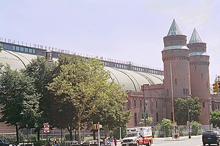
The Kingsbridge Armory, also known as the Eighth Regiment Armory, is a decommissioned armory at Jerome Avenue and West Kingsbridge Road in the Kingsbridge neighborhood of the Bronx in New York City. It was built in the 1910s, from a design by the firm of then-state architect Lewis Pilcher to house the New York National Guard's Eighth Coast Defense Command, a regiment-sized unit which relocated from Manhattan in 1917. It is possibly the largest armory in the world.
Bathgate Industrial Park is an industrial park located in the Morrisania neighborhood of the Bronx, New York City. It is south of the Cross Bronx Expressway, west of Third and Fulton Avenues, north of Claremont Parkway, and east of Washington Avenue in the district of Bronx Community Board 3.
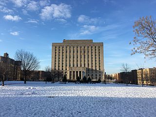
Concourse is a neighborhood in the southwestern section of the New York City borough of the Bronx which includes the Bronx County Courthouse, the Bronx Museum of the Arts, and Yankee Stadium. Its boundaries, starting from the north and moving clockwise, are East 169th Street to the north, Webster Avenue to the east, the Metro-North Railroad's Hudson Line to the south, and Jerome Avenue to the west. The neighborhood is divided into three subsections: West Concourse, East Concourse, and Concourse Village with the Grand Concourse being its main thoroughfare.

