Brooklyn is a borough of New York City located at the westernmost end of Long Island in the State of New York. Formerly an independent city, the borough is coextensive with Kings County, one of twelve original counties established under British rule in 1683 in the then Province of New York. As of the 2020 United States census, the population stood at 2,736,074, making it the most populous of the five boroughs of New York City, and the most populous county in the state. Brooklyn, at 37,339.9 inhabitants per square mile (14,417.0/km2), is the second most densely populated county in the U.S. after Manhattan, as of 2022. Had Brooklyn remained an independent city, it would now be the fourth most populous American city after the rest of New York City, Los Angeles, and Chicago.

Coney Island is a neighborhood and entertainment area in the southwestern section of the New York City borough of Brooklyn. The neighborhood is bounded by Brighton Beach to its east, Lower New York Bay to the south and west, and Gravesend to the north and includes the subsection of Sea Gate on its west. More broadly, the Coney Island peninsula consists of Coney Island proper, Brighton Beach, and Manhattan Beach. This was formerly the westernmost of the Outer Barrier islands on the southern shore of Long Island, but in the early 20th century it became connected to the rest of Long Island by land fill.
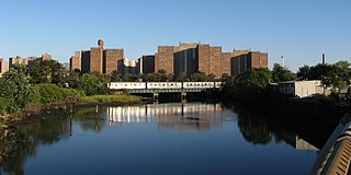
Coney Island Creek is a 1.8-mile-long (2.9 km) tidal inlet in Brooklyn, New York City. It was created from a series of streams and inlets by land filling and digging activities starting in the mid-18th century which, by the 19th century, became a 3-mile-long (4.8 km) continual strait and a partial mudflat connecting Gravesend Bay and Sheepshead Bay, separating Coney Island from the mainland. The strait was closed off in the early 20th century due to further land development and later construction projects. Today only the western half of Coney Island Creek exists. What once was a thriving fish and oyster population in salt marshes, freshwater streams, and expansive forests is now an unnatural environment wrecked by industrial pollution and construction debris. Urbanization of the city and man-made conditions have led to dumping of sewage and discarded materials, including cars and ship parts. Restoration projects are limited and most conservation efforts are seen to be performed by the local community.

Sheepshead Bay is a neighborhood in southern Brooklyn, New York City. It is bounded by Ocean Parkway to the west; Avenue T and Kings Highway to the north; Nostrand Avenue and Gerritsen Avenue to the east; and the Atlantic Ocean to the south. Sheepshead Bay is abutted by the neighborhoods of Brighton Beach, Manhattan Beach, Coney Island and Homecrest, to the west; Midwood to the north; and Gerritsen Beach to the east.

South Brooklyn is a historic term for a section of the former City of Brooklyn – now the New York City borough of Brooklyn – encompassing what are now the Boerum Hill, Carroll Gardens, Cobble Hill, Gowanus, Park Slope, Windsor Terrace, Sunset Park and Red Hook neighborhoods. It was named for its location along the waterfront that was the southern border of the original Village of Brooklyn, and has remained widely used as a colloquialism despite it no longer being the southernmost point of the borough. It should not be confused with the geographic southern region of the modern borough of Brooklyn, which includes the neighborhoods of Gravesend, Seagate, Coney Island, Brighton Beach, Manhattan Beach, Sheepshead Bay, Gerritsen Beach, Marine Park, Mill Basin, and Bergen Beach.
Fulton Ferry is a small area adjacent to Dumbo in the New York City borough of Brooklyn. The neighborhood is named for the Fulton Ferry, a prominent ferry line that crossed the East River between Manhattan and Brooklyn, and is also the name of the ferry slip on the Brooklyn side. The neighborhood is part of Brooklyn Community District 2.

The Port of New York and New Jersey is the port district of the New York-Newark metropolitan area, encompassing the region within approximately a 25-mile (40 km) radius of the Statue of Liberty National Monument.

NYC Health + Hospitals/South Brooklyn Health is a public teaching hospital located in the Coney Island neighborhood of Brooklyn, New York City. It is owned by NYC Health + Hospitals, a public benefit corporation of the city. The hospital is home to FDNY-EMS Station 43, formerly NYC-EMS Station 31, and is a major clinical affiliate for clinical clerkship with the New York Institute of Technology College of Osteopathic Medicine.

Brooklyn Bridge Park is an 85-acre (34 ha) park on the Brooklyn side of the East River in New York City. Designed by landscape architecture firm Michael Van Valkenburgh Associates, the park is located on a 1.3-mile (2.1 km) plot of land from Atlantic Avenue in the south, under the Brooklyn Heights Promenade and past the Brooklyn Bridge, to Jay Street north of the Manhattan Bridge. From north to south, the park includes the preexisting Empire–Fulton Ferry and Main Street Parks; the historic Fulton Ferry Landing; and Piers 1–6, which contain various playgrounds and residential developments. The park also includes Empire Stores and the Tobacco Warehouse, two 19th-century structures, and is a part of the Brooklyn Waterfront Greenway, a series of parks and bike paths around Brooklyn.

St. George Terminal is a ferry, railway, bus, and park and ride transit center in the St. George neighborhood of Staten Island, New York City. It is located at the intersection of Richmond Terrace and Bay Street, near Staten Island Borough Hall, SIUH Community Park and Richmond County Supreme Court. St. George is a rare example of a rail-boat connection in the United States.

The Liberty Landing Ferry, officially known as the Liberty Landing City Ferry, is a commuter ferry service based at Liberty Landing Marina in Jersey City, New Jersey, United States. It provides service between Liberty State Park and Liberty Harbor in Jersey City and the Battery Park City Ferry Terminal at Brookfield Place in Battery Park City, Manhattan. It is one of several private operators of ferries, sightseeing boats, and water taxis in the Port of New York and New Jersey.

The Riegelmann Boardwalk is a 2.7-mile-long (4.3 km) boardwalk on the southern shore of the Coney Island peninsula of Brooklyn in New York City, New York, United States. Opened in 1923, the boardwalk runs along the Atlantic Ocean between West 37th Street to the west, at the edge of the Sea Gate neighborhood, and Brighton 15th Street to the east, in Brighton Beach. It is operated by the New York City Department of Parks and Recreation.

The West Midtown Ferry Terminal is a passenger bus and ferry terminal serving ferries along the Hudson River in New York City and northeastern New Jersey. It is located at Pier 79 in Hudson River Park adjacent to the West Side Highway at West 39th Street in Midtown Manhattan. The facility first opened on December 3, 1986 with the start of NY Waterway commuter ferry service.

The Battery Park City Ferry Terminal, is a passenger ferry terminal in Battery Park City, Manhattan, serving ferries along the Hudson River in New York City and northeastern New Jersey. It provides slips to ferries, water taxis, and sightseeing boats in the Port of New York and New Jersey.

Empire Outlets New York City is a 350,000-square-foot (33,000 m2) retail complex in the St. George neighborhood of Staten Island in New York City. Construction on Empire Outlets started in 2015, and the complex opened on May 15, 2019. Tentative plans called for 100 stores, but there is only space for about 70 stores, less than half of which are currently occupied. It is the first outlet mall in New York City. The mall is located next to the St. George Terminal, a major ferry, train, and bus hub.
NYC Ferry is a public network of ferry routes in New York City operated by Hornblower Cruises. As of August 2023, there are six routes, as well as one seasonal route, connecting 25 ferry piers across all five boroughs. NYC Ferry has the largest passenger fleet in the United States with a total of 38 vessels, providing between 20 and 90 minute service on each of the routes, depending on the season.

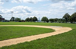
Calvert Vaux Park is an 85.53-acre (34.61 ha) public park in Gravesend, Brooklyn, in New York City. Created in 1934, it is composed of several disconnected sections along the Belt Parkway between Bay 44th and Bay 49th Streets. The peninsula upon which the park is located faces southwest into Gravesend Bay, immediately north of the Coney Island Creek. The park was expanded in the 1960s by waste from the construction of the Verrazzano-Narrows Bridge, and was renamed after architect Calvert Vaux in 1998. It is operated by the New York City Department of Parks and Recreation, also known as NYC Parks.
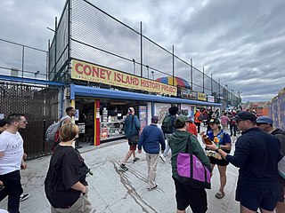
The Coney Island History Project, or CIHP, founded in 2004, is a 501(c)(3) nonprofit organization that works to record and increase awareness of Coney Island's history.

Coney Island Creek Park is a public park on the northwestern coast of Coney Island in Brooklyn, New York City. It abuts Coney Island Creek, Gravesend Bay, and Kaiser Park and is across Coney Island Creek from Calvert Vaux Park and Six Diamonds Park.