Jamaica Bay Wildlife Refuge

Last updated

Jamaica Bay Wildlife Refuge
Jamaica Bay Wildlife Refuge visitor center.jpg
Visitor center
Gateway National Recreation Area Jamaica Bay Unit map.jpg
Jamaica Bay Unit of the
Gateway National Recreation Area
Location New York City, United States
Coordinates 40°36′57″N73°49′48″W / 40.6158°N 73.83°W / 40.6158; -73.83
Area9,155 acres (37.05 km2)
Established1972
Governing body National Park Service
Website Jamaica Bay Wildlife Refuge

Jamaica Bay Wildlife Refuge is a wildlife refuge in New York City managed by the National Park Service as part of Gateway National Recreation Area. It is composed of the open water and intertidal salt marshes of Jamaica Bay. It lies entirely within the boundaries of New York City, divided between the boroughs of Brooklyn to the west and Queens to the east.

Contents

Description

Jamaica Bay Wildlife Refuge consists of several islands in Jamaica Bay, located in both Brooklyn and Queens. The Queens portion is located near John F. Kennedy International Airport, which was built upon a portion of the wetlands in Jamaica Bay. In April 1942, the City of New York started placing hydraulic fill over the marshy tidelands of the area. [1] JFK International Airport is now the sixth busiest airport in the United States, [2] and the aviation traffic may pose some serious noise pollutant threats to the surrounding environment. [3]

The extent of the refuge is mostly open water, but includes upland shoreline and islands with salt marsh, dunes, brackish ponds, woodland and fields. It is the only "wildlife refuge" in the National Park System. Originally created and managed by New York City as a wildlife refuge, the term was retained by Gateway when the site was transferred in 1972. Usually, federal wildlife refuges are managed by the U.S. Fish and Wildlife Service. Features created under city ownership include two large freshwater ponds. A visitor center with a parking lot provides free permits to walk the trails. [4] The two main trails go around the East Pond and the West Pond. [5] The West Pond and its trail, however, were breached by Hurricane Sandy in 2012. [6] [7]

Fauna

Adult female diamondback terrapin Diamondback turtle adult female.jpg
Adult female diamondback terrapin

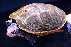
The refuge provides habitat for a wide variety of flora and fauna, both marine and terrestrial. With resident and migratory birds, it is a prime location for birding in New York City. Other animal activities include diamondback terrapin egg laying and horseshoe crab mating and egg laying. The primary diet of the diamondback terrapins include fish, snails, worms, clams, crabs and marsh plants, many of which are abundant in these particular marshlands. [8] Ospreys, which were at one time endangered due to the pesticide DDT, have regularly nested in the refuge since 1991. [9] They are currently being captured, tagged and studied in the Wildlife Refuge to help scientists better understand the birds' habits. [9] Small mammals such as eastern gray squirrels [10] and raccoons [11] are also present in the area. The recently increased raccoon population, however, has developed a taste for diamondback terrapin eggs, and many nests are often destroyed only 24 hours after being laid. [12]

History

1970s
JAMAICA BAY WILDLIFE REFUGE - NARA - 547853.jpg
Birdwatching, June 1973
JAMAICA BAY WILDLIFE REFUGE - NARA - 547854.tif
Conservation sign circa 1973

Planning of the wildlife refuge started as early as 1938 by New York City Department of Parks and Recreation (NYC Parks) commissioner Robert Moses, who wished to rezone the area around Jamaica Bay to prevent any more industries from being built around it. [13] By 1941, Moses planned to convert Jamaica Bay into a 18,000-acre (7,300 ha) recreation center. [14] In 1945, he asked the New York City Board of Estimate to transfer control of Jamaica Bay to NYC Parks so he could convert the bay into what The New York Times described as "a haven for wild life and a mecca for fishermen and boating enthusiasts". [15] After about twelve years of planning, Moses broke ground on the park in 1950. [16]

Moses is credited for introducing the idea of creating nonindigenous freshwater ponds on each side of the refuge. [16] Having freshwater ponds in proximity of the bay's saltwater marshland would attract more varieties of wildlife. [16] About 84,000 workers were employed for the development of the park. [16]

Early years

The first phase of the project was completed in 1953, and Herbert Johnson was appointed as the refuge's first superintendent. [17] The site quickly became a haven for waterfowl and other birds; 208 species of birds were identified in the park's first five years. [16] The refuge attracted species such as black skimmers and snowy egrets, which had not been seen in the New York City area in several decades. [17] Other wildlife such as black bears, coyotes, elk, and even wolves could be found in the park during the early years. [16] Many birdwatchers had begun visiting the park by the late 1950s. [18]

Control of the site passed in 1972 to the National Park Service, [19] [20] which administers the refuge as part of the Gateway National Recreation Area. [21]

21st century

2020s
Jamaica Bay Wildlife Refuge marsh overlook platform.jpg
Marsh overlook platform
Jamaica Bay Wildlife Refuge - panoramio.jpg
West Pond
A somewhat smoggy Midtown Manhattan skyline as seen from Jamaica Bay - panoramio (cropped).jpg
Manhattan skyline viewed from Jamaica Bay

As a result of climate change, the Jamaica Bay area faces effects such as salt marsh erosion, rising sea levels, and flooding. [22] In 2012, Mayor Michael R. Bloomberg and Secretary of the Interior Ken Salazar authorized the creation of the Jamaica Bay-Rockaway Parks Conservancy, Inc. (JBRPC). [23] The public-private organization was officially established in 2013, partners with the National Park Service, the New York City Department of Parks and Recreation and the New York State Department of Parks, Recreation and Historic Preservation, and is "dedicated to improving the 10,000 acres of public parkland throughout Jamaica Bay and the Rockaway peninsula for local residents and visitors alike." [24] [23] Other organizations dedicated to the preservation of the bay include Jamaica Bay Ecowatchers and The American Littoral Society. [22] [25]

In 2016, David Segal and David Hendrick released the documentary Saving Jamaica Bay, narrated by actress Susan Sarandon. [26] The film portrays the history of the national wildlife refuge and current efforts to preserve the natural landscape and wildlife. [27]

In 2018, it was estimated that 365 species have been identified in the park. [16] Out of 417 U.S. national parks, Jamaica Bay ranks second in bird population, higher than Yellowstone or Yosemite. [16]

A $400 million restoration project was begun in 2018 to combat erosion and pollution, remove maritime debris, and clean up storm damage remaining from Hurricane Sandy. [16] The West Pond Loop at the Jamaica Bay Wildlife Refuge reopened in November 2021 after a restoration. [28]

See also

Related Research Articles

<span class="mw-page-title-main">Jamaica Bay</span> Bay on the southern side of Long Island, New York

Jamaica Bay is an estuary on the southern portion of the western tip of Long Island, in the U.S. state of New York. The estuary is partially man-made, and partially natural. The bay connects with Lower New York Bay to the west, through Rockaway Inlet, and is the westernmost of the coastal lagoons on the south shore of Long Island. Politically, it is primarily divided between the boroughs of Brooklyn and Queens in New York City, with a small part touching Nassau County.

<span class="mw-page-title-main">Gateway National Recreation Area</span> National Park Service unit in New York and New Jersey, United States

Gateway National Recreation Area is a 26,607-acre (10,767 ha) U.S. National Recreation Area in New York City and Monmouth County, New Jersey. It provides recreational opportunities that are not commonly found in a dense urban environment, including ocean swimming, bird watching, boating, hiking and camping. More than 8.7 million people visited Gateway National Recreation Area in 2022, making it the fourth-most visited unit of the National Park Service.

<span class="mw-page-title-main">Marine Parkway–Gil Hodges Memorial Bridge</span> Bridge between Brooklyn and Queens, New York

The Marine Parkway–Gil Hodges Memorial Bridge is a vertical-lift bridge in New York City, New York, that crosses Rockaway Inlet. The bridge, which opened on July 3, 1937, connects the Rockaway Peninsula in Queens, with Flatbush Avenue to Floyd Bennett Field, Belt Parkway, and the Marine Park neighborhood in Brooklyn. The bridge is designated as New York State Route 901B, an unsigned reference route.

<span class="mw-page-title-main">Cross Bay Veterans Memorial Bridge</span> Bridge in Queens, New York

The Cross Bay Veterans Memorial Bridge is a toll bridge that carries Cross Bay Boulevard across Jamaica Bay in Queens, New York City, between Broad Channel and the Rockaway Peninsula.

Barren Island is a peninsula and former island on the southeast shore of Brooklyn in New York City. Located on Jamaica Bay, it was geographically part of the Outer Barrier island group on the South Shore of Long Island. The island was occupied by the Lenape Native Americans prior to the arrival of Dutch settlers in the 17th century. Its name is a corruption of Beeren Eylandt, the Dutch-language term for "Bears' Island".

<span class="mw-page-title-main">Rockaway, Queens</span> Neighborhoods of Queens in New York City

The Rockaway Peninsula, commonly referred to as The Rockaways or Rockaway, is a peninsula at the southern edge of the New York City borough of Queens on Long Island, New York. Relatively isolated from Manhattan and other more urban parts of the city, Rockaway became a popular summer retreat in the 1830s. It has since become a mixture of lower, middle, and upper-class neighborhoods. In the 2010s, it became one of the city's most quickly gentrifying areas.

<span class="mw-page-title-main">Broad Channel, Queens</span> Neighborhood of Queens in New York City

Broad Channel is a neighborhood in the southern portion of the New York City borough of Queens. It occupies the southern portion of Rulers Bar Hassock, the only inhabited island in Jamaica Bay.

<span class="mw-page-title-main">Forest Park (Queens)</span> Public park in Queens, New York

Forest Park is a park in the New York City borough of Queens, spanning 538 acres (218 ha). It is the tenth-largest park in New York City and the third-largest in Queens. Created on August 9, 1895, it was originally referred to as Brooklyn Forest Park, as the area was part of Brooklyn at the time.

<span class="mw-page-title-main">Broad Channel station</span> New York City Subway station in Queens

The Broad Channel station is a station on the IND Rockaway Line of the New York City Subway, located in the neighborhood of the same name at Noel and West Roads in the borough of Queens. It is served by the A train and the Rockaway Park Shuttle at all times, the latter of which originates/terminates here. Broad Channel originally opened in 1880 as a Long Island Railroad station. The LIRR discontinued service in 1950 after a fire on the trestle across Jamaica Bay, to the station's north. The station reopened June 28, 1956, as a subway station.

<span class="mw-page-title-main">Arverne, Queens</span> Neighborhood of Queens in New York City

Arverne is a neighborhood in the New York City borough of Queens, on the Rockaway Peninsula. It was initially developed by Remington Vernam, whose signature "R. Vernam" inspired the name of the neighborhood. Arverne extends from Beach 54th Street to Beach 79th Street, along its main thoroughfare Beach Channel Drive, alternatively known as Rev. Joseph H. May Drive.

<span class="mw-page-title-main">Alley Pond Park</span> Public park in Queens, New York

Alley Pond Park is the second-largest public park in Queens, New York City, occupying 655.3 acres (265.2 ha). The park is bordered to the east by Douglaston, to the west by Bayside, to the north by Little Neck Bay, and to the south by Union Turnpike. The Cross Island Parkway travels north-south through the park, while the Long Island Expressway and Grand Central Parkway travel east-west through the park. The park primarily consists of woodlands south of the Long Island Expressway and meadowlands north of the expressway. It is run and operated by the New York City Department of Parks and Recreation.

<span class="mw-page-title-main">Dead Horse Bay</span> Bay in Brooklyn, New York

Dead Horse Bay is a small body of water off Barren Island, between the Gerritsen Inlet and Rockaway Inlet in the New York City borough of Brooklyn.

<span class="mw-page-title-main">Jacob Riis Park</span> Urban park in Queens, New York

Jacob Riis Park, also called Jacob A. Riis Park and Riis Park, is a seaside park on the southwestern portion of the Rockaway Peninsula in the New York City borough of Queens. It lies at the foot of the Marine Parkway–Gil Hodges Memorial Bridge, east of Fort Tilden, and west of Neponsit and Rockaway Beach. Originally run by the New York City Department of Parks and Recreation, it later became part of the Jamaica Bay Unit of the Gateway National Recreation Area, and is managed by the National Park Service (NPS). It features an extensive sand beach along the Atlantic Ocean coastline and several historic Art Deco structures.

<span class="mw-page-title-main">Spring Creek, Brooklyn</span> Neighborhood of Brooklyn in New York City

Spring Creek, previously called Spring Creek Basin, is a neighborhood within the East New York section of Brooklyn in New York City. It roughly comprises the southern portions of East New York between Flatlands Avenue to the north, and Jamaica Bay and the Gateway National Recreation Area to the south, with the Brooklyn neighborhood of Canarsie to the west and the Queens neighborhood of Howard Beach to the east. It is named after Spring Creek, one of several creeks that formerly ran through the area and drained into Jamaica Bay.

<span class="mw-page-title-main">The Raunt station</span>

The Raunt was a former Long Island Rail Road station on the Rockaway Beach Branch. It had no address and no station house, because it was meant strictly as a dropping-off point for fishermen using a small island in Jamaica Bay. The station was located 1,300 feet (400 m) west of signal station "ER", and near the WU Tower. It was named for the channel on the south side of the island where it stood.

<span class="mw-page-title-main">Baisley Pond Park</span> Public park in Queens, New York

Baisley Pond Park is a public park located in the southeastern part of Queens, New York City, bordering the neighborhoods of South Jamaica, Rochdale, and St. Albans. It covers 109.61 acres (44.36 ha), including the 30-acre (12 ha) Baisley Pond in the center of the park. It is maintained by the New York City Department of Parks and Recreation.

<span class="mw-page-title-main">Spring Creek Park</span> Public park in New York City

Spring Creek Park is a public park along the Jamaica Bay shoreline between the neighborhoods of Howard Beach, Queens, and Spring Creek, Brooklyn, in New York City. Created on landfilled former marshland, the park is mostly an undeveloped nature preserve, with only small portions accessible to the public for recreation.

<span class="mw-page-title-main">Edgemere Landfill</span> Former landfill in Queens, New York

Edgemere Landfill is a former municipal landfill located in Edgemere on the Rockaway peninsula in Queens, New York City. It is located on a man-made peninsula on the Jamaica Bay shoreline, at the eastern end of the Rockaway peninsula. A portion of the site is currently open to the public as Rockaway Community Park. The entire site is owned by the New York City Department of Parks and Recreation.

<span class="mw-page-title-main">Birding in New York City</span>

New York City is home to a large birding community and diverse range of bird species. Though it is the most populous and most densely populated city in the United States, NYC is home to a range of ecological habitats and is situated along the Atlantic Flyway, a major route for migrating birds. More than 400 species have been recorded in the city, and their concentration in the city's urban parklands, forests, marshes, and beaches has made birding a popular activity in the city, especially after the start of the COVID-19 pandemic.

References

  1. "History of JFK International Airport". The Port Authority of New York and New Jersey. Retrieved October 3, 2013.
  2. "(JFK) John F. Kennedy International Airport Overview". FlightStats, Inc. Retrieved October 3, 2013.
  3. Cohen, Beverly; Brozaft, Arline; Goodman, Jerome; Nádas, Arthur; Heikkinen, Maire (February 2008). "Airport-Related Air Pollution and Noise". Journal of Occupational and Environmental Hygiene. 5 (2): 119–129. doi:10.1080/15459620701815564.
  4. Jamaica Bay Wildlife Refuge New York Harbor Parks
  5. "Jamaica Bay Wildlife Refuge". National Park Service. May 26, 2023. Retrieved May 29, 2023.
  6. Rafter, Domenick (November 21, 2012). "Jamaica Bay walloped by Hurricane Sandy". Queens Chronicle. Retrieved May 29, 2023.
  7. Feis, Aaron (October 28, 2022). "Ruin, recovery, resilience: How Superstorm Sandy impacted our beaches, parks". PIX11. Retrieved May 29, 2023.
  8. "Diamondback Terrapin". Defenders of Wildlife. Retrieved October 3, 2013.
  9. 1 2 Foderaro, Lisa W. (May 2, 2012). "An Earth-Bound View of Where Ospreys Soar". The New York Times. ISSN   0362-4331 . Retrieved September 20, 2022.
  10. Huynh, Howard; Williams, Geoffrey; McAlpine, Donald; Thorington, Richard (December 2010). "Establishment of the Eastern Gray Squirrel (Sciurus carolinensis) in Nova Scotia, Canada". Northeastern Naturalist. 17 (4): 673–677. doi:10.1656/045.017.0414.
  11. Burke, Russell; Felice, Susan; Sobel, Sabrina (December 2009). "Changes in Raccoon (Procyon lotor) Predation Behavior Affects Turtle (Malaclemys terrapin) Nest Census". Chelonian Conservation and Biology. 8 (2): 208–211. doi:10.2744/ccb-0775.1.
  12. Newman, Andy (July 17, 2002). "Turtle Soup? Raccoons Like Eggs; A Hungry Invader Threatens Terrapins in Jamaica Bay". The New York Times. Retrieved March 11, 2023.
  13. "Jamaica Bay Plan Pushed by Moses; He Says He Will Ask Planning Commission Within 2 Weeks to Rezone the Area". The New York Times. July 26, 1938. ISSN   0362-4331 . Retrieved March 11, 2023.
  14. Bennett, Charles G. (June 29, 1941). "Jamaica Bay to Be Play Area; Its 18,000 Acres of Water and Marshland Are Being Cleaned Up and Developed for Swimming, Boating and Fishing". The New York Times. ISSN   0362-4331 . Retrieved March 11, 2023.
  15. "Jamaica Bay Seen as Sport Paradise; Moses Asks Estimate Board to Place Islands There Under Park Jurisdiction". The New York Times. March 2, 1945. ISSN   0362-4331 . Retrieved March 11, 2023.
  16. 1 2 3 4 5 6 7 8 9 Sharma, Neglah (August 2, 2018). "What Robert Moses did for Jamaica Bay". Queens Chronicle. Archived from the original on January 18, 2020. Retrieved March 11, 2023.
  17. 1 2 "Bird Life Revives on Jamaica Bay; New Sanctuary Is Thriving --Snowy Egrets and Heron Nest in Sight of City". The New York Times. May 7, 1955. ISSN   0362-4331 . Retrieved March 11, 2023.
  18. Devlin, John C. (October 19, 1959). "Birds and People Find Refuge Here; Breezy Jamaica Bay Retreat Draws Tired City Folk, as Well as Ornithologists". The New York Times. ISSN   0362-4331 . Retrieved March 11, 2023.
  19. Madden, Richard L. (September 27, 1972). "House Votes Bill on Gateway Area But Kills Housing". The New York Times. ISSN   0362-4331 . Retrieved March 11, 2023.
  20. "AN ACT To establish the Gateway National Recreation Area in the States of New York and New Jersey, and for other purposes.". Public Law 92-592, Act of October 27, 1972 (PDF). Retrieved January 12, 2018.
  21. "Jamaica Bay Wildlife Refuge". Gateway National Recreation Area. National Park Service. Retrieved March 11, 2023.
  22. 1 2 Kensinger, Nathan (March 17, 2016). "Forecasting NYC's Climate Change Future in Jamaica Bay". Curbed NY. Retrieved April 29, 2021.
  23. 1 2 "Who We Are". Jamaica Bay-Rockaway Parks Conservancy. Retrieved April 29, 2021.
  24. "Improving Parkland Through Partnership". The Wave | Rockaway Beach, NY. July 23, 2020. Retrieved April 29, 2021.
  25. "Jamaica Bay Ecowatchers". jamaicabayecowatchers.org. Retrieved April 29, 2021.
  26. Sigal, David (March 17, 2016), Saving Jamaica Bay (Documentary), Susan Sarandon, Grounded Truth Productions, retrieved April 29, 2021
  27. Kern-Jedrychowska, Ewa (March 16, 2016). "Susan Sarandon Narrates Documentary to Raise Awareness About Jamaica Bay". DNAinfo New York. Archived from the original on April 30, 2021. Retrieved April 29, 2021.
  28. Bardolf, Deirdre (November 24, 2021). "Jamaica Bay site restored and reinforced". Queens Chronicle. Retrieved July 25, 2023.