Grand Army Plaza

Last updated

Grand Army Plaza
Grand Army Plaza Brooklyn New York August 2013.jpg
Grand Army Plaza viewed from the southeast, anchored by the Soldiers' and Sailors' Arch
USA New York City location map.svg
Red pog.svg
Location within New York City
USA New York location map.svg
Red pog.svg
Location within New York
Usa edcp location map.svg
Red pog.svg
Location within the United States
Location Brooklyn, New York City, New York, United States
Coordinates 40°40′27″N73°58′13″W / 40.6743°N 73.9702°W / 40.6743; -73.9702
Area14.26 acres (5.77 ha) [1]
Elevation131 ft (40 m) [2]

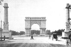
Grand Army Plaza, originally known as Prospect Park Plaza, is a public plaza that comprises the northern corner and the main entrance [3] of Prospect Park in the New York City borough of Brooklyn. It consists of concentric oval rings arranged as streets, with the namesake Plaza Street comprising the outer ring. The inner ring is arranged as an ovoid roadway that carries the main street – Flatbush Avenue. Eight radial roads connect Vanderbilt Avenue; Butler Place; two separate sections of Saint John's Place; Lincoln Place; Eastern Parkway; Prospect Park West; Union Street; and Berkeley Place. The only streets that penetrate to the inner ring are Flatbush Avenue, Vanderbilt Avenue, Prospect Park West, Eastern Parkway, and Union Street.

Contents

The plaza includes the Soldiers' and Sailors' Arch; the Bailey Fountain; the John F. Kennedy Monument; statues of Civil War generals Gouverneur K. Warren and Henry Warner Slocum; busts of notable Brooklyn citizens Alexander Skene and Henry W. Maxwell; and two 12-sided gazebos with "granite Tuscan columns, Guastavino vaulting, and bronze finials". [4] :668

History

Arch and columns in 1894 without sculptures; the low dome beyond the archway at ground level is the 1873 fountain. Grand Army Plaza 1894.jpg
Arch and columns in 1894 without sculptures; the low dome beyond the archway at ground level is the 1873 fountain.

The site of the future Grand Army Plaza was in the 17th century a pass through the Heights of Guan. It played a small role in the 1776 Battle of Long Island, the biggest battle of the American Revolutionary War.

The 1861 plan for Prospect Park included an elliptical plaza at the intersection of Flatbush and Ninth avenues. [5] In 1867, the plaza was designed by Frederick Law Olmsted and Calvert Vaux as a grand entrance to the Park to separate the noisy city from the calm nature of the Park. Olmsted and Vaux's design included only the Fountain of the Golden Spray and the surrounding earth embankments covered in heavy plantings. The berms still shield the local apartment buildings and the Brooklyn Central Library from the noisy traffic circle that has developed. By 1869 the Abraham Lincoln statue by Henry Kirke Brown [6] was north of the plaza fountain's stairs, and the statue was moved to the lower terrace of the park's Concert Grove in 1895. [5]

The original 1867 fountain was successively replaced by an 1873 lighted fountain, an 1897-1915 fountain for exhibitions, and the 1932 Bailey Fountain, renovated in 2006.

Henry W. Maxwell Memorial (1903) HenryMaxwellMemorialTablet.jpg
Henry W. Maxwell Memorial (1903)

In 1895, three bronze sculpture groups were added to the 1892 Soldiers' and Sailors' Arch.

In 1926, the plaza, previously known as Prospect Park Plaza, was renamed Grand Army Plaza to commemorate the sixtieth anniversary of the foundation of the Grand Army of the Republic, a fraternal organization composed of veterans of the Union Army and other military services who served in the American Civil War. [8]

In 1975, Grand Army Plaza became a National Historic Landmark. [9] A private funding campaign in 1999 was established to restore the monument. In 2018, keystones from the roof fell and protective barriers were placed around the monument to safeguard pedestrians. A full restoration of the arch and statue was done in 2021, sponsored by the City and Prospect Park Alliance. [10]

In 2008, a competition was held for designs to reorganize Grand Army Plaza to make it a more integral part of Prospect Park and more accessible to pedestrians. [11] At the same time, the New York City Department of Transportation (NYCDOT) made improvements in accessibility, putting sidewalks and planters in many of the striped areas. These improvements made it somewhat easier and safer for pedestrians and cyclists to cross from the park to the library and to the plaza. The changes made by the NYCDOT were modest in comparison to those in the designs in the competition, most of which called for the rerouting of some of the vast traffic flow. [12]

In November 2022, the NYCDOT started soliciting public feedback for a proposal to close Grand Army Plaza permanently to vehicular traffic, converting the plaza to a pedestrian zone. [13] [14] The proposed pedestrian zone would connect with Underhill and Vanderbilt Avenues; these roads are part of the city's Open Streets program, where vehicular traffic is restricted during certain times of day. [14]

Use

Grand Army Plaza
Map of notable buildings and structures at Prospect Park (note: not all entrances shown). Click on points for more details.
'"`UNIQ--templatestyles-00000032-QINU`"''"`UNIQ--templatestyles-00000033-QINU`"'

The area around the Arch forms the largest and busiest traffic circle in Brooklyn, being the convergence of Flatbush Avenue, Vanderbilt Avenue, Eastern Parkway, Prospect Park West, and Union Street. In 1927, Brooklyn's "Death-O-Meter", a sign admonishing drivers to "Slow Up" and displaying a continually updated tally of traffic accident deaths in the borough, was installed. [15]

A popular farmer's market, part of the Greenmarket program of GrowNYC is held on the plaza in front of Prospect Park every Saturday from 8 a.m. to 3 p.m. [16]

The station is served by two New York City Subway stations and multiple bus routes. The Grand Army Plaza station ( 2 and 3 trains), built in 1920 on the IRT Eastern Parkway Line, is on the north end of the Plaza, while the Seventh Avenue station ( B and Q trains) on the BMT Brighton Line is several blocks northwest. [17] The B67 and B69 buses stop at Union Street and 7th Avenue, two blocks north, while the B41 bus stops on Flatbush Avenue. [18]

1 Grand Army Plaza.jpg
Richard Meier's 1 Grand Army Plaza apartment building was completed in 2009; the AIA Guide calls it "a massive beached whale". [19]
Grand Army Plaza (40528803143).jpg
Grand Army Plaza on a summer night

See also

Related Research Articles

<span class="mw-page-title-main">Prospect Park (Brooklyn)</span> Public park in Brooklyn, New York

Prospect Park is an urban park in the New York City borough of Brooklyn. The park is situated between the neighborhoods of Park Slope, Prospect Heights, Prospect Lefferts Gardens, Flatbush, and Windsor Terrace, and is adjacent to the Brooklyn Museum, Grand Army Plaza, and the Brooklyn Botanic Garden. With an area of 526 acres (213 ha), Prospect Park is the second-largest public park in Brooklyn, behind Marine Park. Designated as a New York City scenic landmark and listed on the National Register of Historic Places, Prospect Park is operated by the Prospect Park Alliance and NYC Parks.

<span class="mw-page-title-main">Interstate 278</span> Interstate Highway in New Jersey and New York

Interstate 278 (I-278) is an auxiliary Interstate Highway in New Jersey and New York in the United States. The road runs 35.62 miles (57.32 km) from US Route 1/9 (US 1/9) in Linden, New Jersey, northeast to the Bruckner Interchange in the New York City borough of the Bronx. The majority of I-278 is in New York City, where it serves as a partial beltway and passes through all five of the city's boroughs. I-278 follows several freeways, including the Union Freeway in Union County, New Jersey; the Staten Island Expressway (SIE) across Staten Island; the Gowanus Expressway in southern Brooklyn; the Brooklyn–Queens Expressway (BQE) across northern Brooklyn and Queens; a small part of the Grand Central Parkway in Queens; and a part of the Bruckner Expressway in the Bronx. I-278 also crosses multiple bridges, including the Goethals, Verrazzano-Narrows, Kosciuszko, and Robert F. Kennedy bridges.

<span class="mw-page-title-main">Bergen Street station (IRT Eastern Parkway Line)</span> New York City Subway station in Brooklyn

The Bergen Street station is a local station on the IRT Eastern Parkway Line of the New York City Subway, located at Bergen Street and Flatbush Avenue in Park Slope, Brooklyn. It is served by the 2 train at all times, the 3 train at all times except late nights, and the 4 train during late nights.

<span class="mw-page-title-main">Grand Army Plaza station</span> New York City Subway station in Brooklyn

The Grand Army Plaza station is a local station on the IRT Eastern Parkway Line of the New York City Subway. It is located in Park Slope, Brooklyn, underneath Flatbush Avenue at its intersection with Plaza Street West and St. Johns Place, on the northwest side of Grand Army Plaza. It is served by the 2 train at all times, the 3 train at all times except late nights, and the 4 train during late nights.

<span class="mw-page-title-main">Eastern Parkway–Brooklyn Museum station</span> New York City Subway station in Brooklyn

The Eastern Parkway–Brooklyn Museum station is a local station on the IRT Eastern Parkway Line of the New York City Subway. Located at the intersection of Washington Avenue and Eastern Parkway in Brooklyn adjacent to the Brooklyn Museum, it is served by the 2 train at all times, the 3 train at all times except late nights, and the 4 train during late nights.

<span class="mw-page-title-main">Windsor Terrace, Brooklyn</span> Neighborhood of Brooklyn in New York City

Windsor Terrace is a small residential neighborhood in the central part of the New York City borough of Brooklyn. It is bounded by Prospect Park on the east and northeast, Park Slope at Prospect Park West, Green-Wood Cemetery, and Borough Park at McDonald Avenue on the northwest, west, and southwest, and Kensington at Caton Avenue on the south. As of the 2010 United States Census, Windsor Terrace had 20,988 people living within its 0.503-square-mile (1.30 km2) area.

<span class="mw-page-title-main">Prospect Heights, Brooklyn</span> Neighborhood of Brooklyn in New York City

Prospect Heights is a neighborhood in the northwest of the New York City borough of Brooklyn. The traditional boundaries are Flatbush Avenue to the west, Atlantic Avenue to the north, Eastern Parkway – beginning at Grand Army Plaza – to the south, and Washington Avenue to the east. In the northern section of Prospect Heights are the Vanderbilt Rail Yards, built over as part of the Pacific Park project. The Barclays Center, home to the NBA's Brooklyn Nets basketball team, is located in the northwestern corner of the neighborhood in Pacific Park at Flatbush and Atlantic Avenues.

<span class="mw-page-title-main">Queens Boulevard</span> Boulevard in Queens, New York

Queens Boulevard is a major thoroughfare in the New York City borough of Queens connecting Midtown Manhattan, via the Queensboro Bridge, to Jamaica. It is 7.5 miles (12.1 km) long and forms part of New York State Route 25.

<span class="mw-page-title-main">Flatbush Avenue</span> Avenue in Brooklyn, New York

Flatbush Avenue is a major avenue in the New York City Borough of Brooklyn. It runs from the Manhattan Bridge south-southeastward to Jamaica Bay, where it joins the Marine Parkway–Gil Hodges Memorial Bridge, which connects Brooklyn to the Rockaway Peninsula in Queens. The north end was extended from Fulton Street to the Manhattan Bridge as "Flatbush Avenue Extension".

<span class="mw-page-title-main">Seventh Avenue station (BMT Brighton Line)</span> New York City Subway station in Brooklyn

The Seventh Avenue station is a station on the BMT Brighton Line of the New York City Subway, located at the intersection of Seventh Avenue, Park Place and Flatbush Avenue in Park Slope and Prospect Heights, Brooklyn. The station is served by the Q train at all times and by the B train on weekdays only.

<span class="mw-page-title-main">Ocean Parkway (Brooklyn)</span> Boulevard in Brooklyn, New York

Ocean Parkway is a 4.86-mile-long (7.82 km) boulevard in the west-central portion of the New York City borough of Brooklyn. It is inventoried by the New York State Department of Transportation (NYSDOT) as New York State Route 908H (NY 908H), an unsigned reference route.

Vanderbilt Avenue is the name of three thoroughfares in the New York City boroughs of Brooklyn, Manhattan, and Staten Island. They were named after Cornelius Vanderbilt (1794–1877), the builder of Grand Central Terminal in Midtown Manhattan.

<span class="mw-page-title-main">Eastern Parkway</span> Boulevard in Brooklyn, New York

Eastern Parkway is a major east–west road in the New York City borough of Brooklyn. Designed by Frederick Law Olmsted and Calvert Vaux, it was built between 1870 and 1874 and has been credited as the world's first parkway. At the time of its construction, Eastern Parkway went to the eastern edge of Brooklyn, hence its name.

<span class="mw-page-title-main">B44 (New York City bus)</span> Bus route in Brooklyn, New York

The B44 is a public transit line in Brooklyn, New York City, running mostly along Nostrand Avenue, as well as northbound on Rogers Avenue or New York Avenue and Bedford Avenue, between Sheepshead Bay and Williamsburg. Originally a streetcar line, it is now the B44 bus route, operated by the New York City Transit Authority.

Nassau Railroad Company was a streetcar company that ran in Queens and Kings Counties in the State of New York during the 1850s and 1860s.

<span class="mw-page-title-main">Fourth Avenue (Brooklyn)</span> Avenue in Brooklyn, New York

Fourth Avenue is a major thoroughfare in the New York City borough of Brooklyn. It stretches for 6 miles (9.7 km) south from Times Plaza, which is the triangle intersection created by Atlantic and Flatbush Avenues in Downtown Brooklyn, to Shore Road and the Belt Parkway in Bay Ridge.

<i>Bailey Fountain</i> Fountain and sculpture in Brooklyn, New York, U.S.

Bailey Fountain is an outdoor sculpture in New York City at the site of three 19th century fountains in Grand Army Plaza, Brooklyn, New York, United States. Renovated in 1956 and 2005-06, the 1932 fountain was funded by philanthropist Frank Bailey as a memorial to his wife Mary Louise Bailey. After 1974 thefts, some sculpture elements were stored for safekeeping. The bronze Art Deco design of the Bailey Fountain consists of six monumental figures beginning with the top two, a man representing Wisdom with his left hand on the tiller steering the ship of Life and a woman representing Felicity with her right hand holding a cornucopia. Below them are two other statues, one a chubby standing child helping to shoulder that cornucopia while the second is a laughing Greek mythological figure called Nereus who is the eldest son of Pontus the Sea and Gaia the Earth. To the sides of the fountain are the two remaining aquatic Nereides / sea nymph figures with upper torsos emerging from the water their heads back trumpeting with conch shells as their fish tails twist in the background.

The IRT Eastern Parkway Line is one of the lines of the A Division of the New York City Subway. Built for the Interborough Rapid Transit Company (IRT), it stretches from Downtown Brooklyn south along Flatbush Avenue and east along Eastern Parkway to Crown Heights. After passing Utica Avenue, the line rises onto an elevated structure and becomes the New Lots Line to the end at New Lots Avenue in East New York, Brooklyn. The west end of the Eastern Parkway Line is at the Joralemon Street Tunnel under the East River.

<span class="mw-page-title-main">Bus lanes in New York City</span> Bus priority system

Since 1963, New York City has been using a system of bus lanes that are intended to give priority to buses, which contain more occupants than passenger and commercial vehicles. Most of these lanes are restricted to buses only at certain days and times, but some bus lanes are restricted 24/7. As of May 2021, there are 138.4 miles (222.7 km) of bus lanes within New York City.

<span class="mw-page-title-main">Willink Plaza</span> Intersection in Brooklyn, New York

The Willink Entrance area, also known as Willink Plaza, is a major urban square of Brooklyn, New York City, formed by the intersection of Flatbush Avenue, Ocean Avenue and Empire Boulevard, at the eastern corner of Prospect Park and the southern corner of the Brooklyn Botanic Garden. It is serviced by the New York City Subway's Prospect Park station, and features several public spaces and historic buildings. This location is considered the northwestern point of the Prospect Lefferts Gardens neighborhood of Flatbush, and adjoins Crown Heights to its northeast.

References

  1. "Bailey Fountain" (Historical Signs Project webpage for park marker). Grand Army Plaza. nycgovparks.org. Archived from the original on October 10, 2012. Retrieved August 19, 2011.{{cite web}}: External link in |format= (help)
  2. "X_Value=-73.970156&Y_Value=40.674253". USGS Elevation Web Service Query. United States Geological Survey. Archived from the original on March 30, 2012. Retrieved June 24, 2011.
  3. "Prospect Park". Brooklyn Daily Eagle . June 20, 1867. p. 2. Archived from the original on June 12, 2011. Retrieved February 5, 2019 via Newspapers.com. Entering at the main entrance or plaza, the visitor leaves on either side the mounds which flank the spot selected for the Fountain of the Gold Spray.
  4. White, Norval; Willensky, Elliot (2000). AIA Guide to New York City (4th ed.). New York Chapter, American Institute of Architects; Crown Publishers/Random House. ISBN   0-8129-3106-8.
  5. 1 2 Lancaster, Clay (1972) [1967]. Prospect Park Handbook. New York: Long Island University Press. ISBN   0-913252-06-9. Archived from the original on July 20, 2011. Retrieved August 22, 2011. On 20 October 1917 Brooklyn celebrated the 50th anniversary of the opening of Prospect Park, and the ceremony took place at the triumphal arch on Grand Army Plaza.
  6. "Grand Army Plaze" Archived July 12, 2011, at the Wayback Machine on the Prospect Park Alliance website
  7. "Grand Army Plaze: Henry W. Maxwell Memorial" Archived December 25, 2009, at the Wayback Machine on the NYC.gov website
  8. New York Times, Plaza in Brooklyn Dedicated to G.A.R. Archived July 22, 2018, at the Wayback Machine , May 10, 1926, page 9
  9. Ziegenfuss, Kathleen. "Grand Army Plaza". Hall of Shame. PPS.org. Archived from the original on July 16, 2011. Retrieved August 1, 2011. In 1975, Grand Army Plaza became a National Historic Landmark
  10. Verde, Ben. "City reveals designs for Grand Army Plaza restoration". Brooklyn Paper. Archived from the original on November 22, 2020. Retrieved November 22, 2020.
  11. "Design Trust". Archived from the original on October 12, 2007. Retrieved June 17, 2009.
  12. "Grand Army Plaza enhancements" (PDF). Archived (PDF) from the original on December 24, 2012. Retrieved May 18, 2013.
  13. "Could Grand Army Plaza be Brooklyn's next car-free space? The city's department of transportation thinks so. | WNYC | New York Public Radio, Podcasts, Live Streaming Radio, News". WNYC. Archived from the original on November 11, 2022. Retrieved November 11, 2022.
  14. 1 2 Nessen, Stephen (November 10, 2022). "Exclusive: DOT eyes Brooklyn's Grand Army Plaza as NYC's next car-free space". Gothamist. Archived from the original on November 11, 2022. Retrieved November 11, 2022.
  15. "Grand Army Plaza". New York City Parks. Archived from the original on May 18, 2015. Retrieved May 10, 2015.
  16. "Grand Army Plaza Greenmarket". GrowNYC. September 29, 2007. Archived from the original on December 27, 2022. Retrieved December 27, 2022.
  17. "Subway Map" (PDF). Metropolitan Transportation Authority. September 2021. Retrieved September 17, 2021.
  18. "Brooklyn Bus Map" (PDF). Metropolitan Transportation Authority. October 2020. Retrieved December 1, 2020.
  19. White, Norval; Willensky, Elliot; Leadon, Fran (2010). AIA Guide to New York City (5th ed.). New York: Oxford University Press. p. 669. ISBN   978-0-19538-386-7.