
Brooklyn is a borough of New York City. Located on the westernmost edge of Long Island, it is coextensive with Kings County in the U.S. state of New York. With 2,736,074 residents as of the 2020 United States census, Kings County is the most populous of the five boroughs of New York City and the most populous county in the State of New York. The population density of Brooklyn was 37,339.9 inhabitants per square mile (14,417.0/km2) in 2022, making it the second-most-densely-populated county in the United States, behind Manhattan, and it had the ninth-highest population of any county nationwide. Were Brooklyn still an independent city, it would be the fourth most populous in the U.S. after the rest of New York City, Los Angeles, and Chicago.

The Battle of Long Island, also known as the Battle of Brooklyn and the Battle of Brooklyn Heights, was an action of the American Revolutionary War fought on August 27, 1776, at and near the western edge of Long Island in present-day Brooklyn. The British defeated the Continental Army and gained access to the strategically important Port of New York, which they held for the rest of the war. It was the first major battle to take place after the United States declared its independence on July 4, 1776, in Philadelphia. It was the largest battle of the Revolutionary War in terms of both troop deployment and combat.
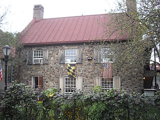
The Old Stone House is a house located in the Park Slope neighborhood of Brooklyn, New York City. The Old Stone House is situated within the J. J. Byrne Playground, at Washington Park, on Third Street between Fourth and Fifth Avenues. Gowanus Creek once ran nearby, but today the southeastern branch of the Gowanus Canal ends 1,300 feet (400 m) west of the house.

The Belt Parkway is the name given to a series of controlled-access parkways that form a belt-like circle around the New York City boroughs of Brooklyn and Queens. The Belt Parkway comprises three of the four parkways in what is known as the Belt System: the Shore Parkway, the Southern Parkway, and the Laurelton Parkway. The three parkways in the Belt Parkway are a combined 25.29 miles (40.70 km) in length. The Cross Island Parkway makes up the fourth parkway in the system, but is signed separately.
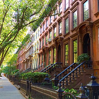
Park Slope is a neighborhood in northwestern Brooklyn, New York City, within the area once known as South Brooklyn. Park Slope is roughly bounded by Prospect Park and Prospect Park West to the east, Fourth Avenue to the west, Flatbush Avenue to the north, and Prospect Expressway to the south. Generally, the section from Flatbush Avenue to Garfield Place is considered the "North Slope", the section from 1st to 9th Street is considered the "Center Slope", and south from 9th Street, the "South Slope". The neighborhood takes its name from its location on the western slope of neighboring Prospect Park. Fifth Avenue and Seventh Avenue are its primary commercial streets, while its east–west side streets are lined with brownstones and apartment buildings.

Prospect Heights is a neighborhood in the northwest of the New York City borough of Brooklyn. The traditional boundaries are Flatbush Avenue to the west, Atlantic Avenue to the north, Eastern Parkway – beginning at Grand Army Plaza – to the south, and Washington Avenue to the east. In the northern section of Prospect Heights are the Vanderbilt Rail Yards, built over as part of the Pacific Park project. The Barclays Center, home to the NBA's Brooklyn Nets basketball team, is located in the northwestern corner of the neighborhood in Pacific Park at Flatbush and Atlantic Avenues.

Flatbush Avenue is a major avenue in the New York City Borough of Brooklyn. It runs from the Manhattan Bridge south-southeastward to Jamaica Bay, where it joins the Marine Parkway–Gil Hodges Memorial Bridge, which connects Brooklyn to the Rockaway Peninsula in Queens. The north end was extended from Fulton Street to the Manhattan Bridge as "Flatbush Avenue Extension".

South Brooklyn is a historic term for a section of the former City of Brooklyn – now the New York City borough of Brooklyn – encompassing what are now the Boerum Hill, Carroll Gardens, Cobble Hill, Gowanus, Park Slope, Windsor Terrace, Sunset Park and Red Hook neighborhoods. It was named for its location along the waterfront that was the southern border of the original Village of Brooklyn, and has remained widely used as a colloquialism despite it no longer being the southernmost point of the borough. It should not be confused with the geographic southern region of the modern borough of Brooklyn, which includes the neighborhoods of Gravesend, Seagate, Coney Island, Brighton Beach, Manhattan Beach, Sheepshead Bay, Gerritsen Beach, Marine Park, Mill Basin, and Bergen Beach.
Mount Prospect Park is a 7.79-acre (3.15 ha) park in the central portion of the New York City borough of Brooklyn. It includes Mount Prospect, the second highest point in Brooklyn. It is located on Eastern Parkway near Underhill Avenue, close to Grand Army Plaza. The park is operated by the New York City Department of Parks and Recreation.
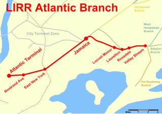
The Atlantic Branch is an electrified rail line owned and operated by the Long Island Rail Road in the U.S. state of New York. It is the only LIRR line with revenue passenger service in the borough of Brooklyn.

Forest Park is a park in the New York City borough of Queens, spanning 538 acres (218 ha). It is the tenth-largest park in New York City and the third-largest in Queens. Created on August 9, 1895, it was originally referred to as Brooklyn Forest Park, as the area was part of Brooklyn at the time.

Community boards of Brooklyn are New York City community boards in the borough of Brooklyn, which are the appointed advisory groups of the community districts that advise on land use and zoning, participate in the city budget process, and address service delivery in their district.
The Manhattan Beach Branch, Manhattan Beach Line, or Manhattan Beach Division was a line of the Long Island Rail Road, running from Fresh Pond, Queens, south to Manhattan Beach, Brooklyn, New York City, United States. It opened in 1877 and 1878 as the main line of the New York and Manhattan Beach Railway. The tracks from Flatbush south to Manhattan Beach were removed from 1938 to 1941, while most of the rest is now the freight-only Bay Ridge Branch.

Greenwood Heights is a neighborhood in the New York City borough of Brooklyn, named partially after the adjacent Green-Wood Cemetery. Greenwood Heights is a part of Brooklyn Community District 7 along with Windsor Terrace, Sunset Park and South Slope. The much-debated borders are roughly the Prospect Expressway to the north, Gowanus Canal and Upper New York Bay to the west, Eighth Avenue to the east, and 39th Street to the south.

The Red Lion Inn was a tavern in Colonial New York located on Long Island in what is today the New York City borough of Brooklyn.
Each of New York City's five counties has its own criminal court system and District Attorney, the chief public prosecutor who is directly elected by popular vote. Charles J. Hynes, a Democrat, was the District Attorney of Kings County from 1990 to 2013. Brooklyn has 16 City Council members, the largest number of any of the five boroughs. The Brooklyn Borough Government includes a borough government president as well as a court, library, borough government board, head of borough government, deputy head of borough government and deputy borough government president.

Battle Hill is the highest natural point in Brooklyn, New York, United States, at 216 feet (66 m) above sea level. The hill is part of the Harbor Hill Moraine, a terminal moraine formed during the last glacial period. Battle Hill, located in what is today Green-Wood Cemetery, received its name from the battle which occurred on its slopes between American troops under the immediate command of General Samuel Holden Parsons and British troops under the command of General James Grant.
Prospect Avenue is a major street in Brooklyn, New York.

Battle Pass, formerly known as Flatbush Pass or Valley Grove or The Porte, is a historic hill pass that played a significant part in the 1776 Battle of Long Island, and that is currently part of Prospect Park in Brooklyn.
![A portion of Howes Map (1776) showing "The Heights" [of Guan], north of the village of Flatbush Battle of Brooklyn.gif](http://upload.wikimedia.org/wikipedia/commons/thumb/9/9c/Battle_of_Brooklyn.gif/240px-Battle_of_Brooklyn.gif)