
The Bronx Kill is a narrow strait in New York City delineating the southernmost extent of the Bronx. It separates the Bronx from Randalls Island. It connects the Harlem River to the East River.

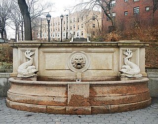
Coogan's Bluff is a promontory near the western shore of the Harlem River in the Washington Heights neighborhood of Upper Manhattan in New York City. Its boundaries extend approximately from 155th Street and the Macombs Dam Bridge viaduct to 160th Street, between Edgecombe Avenue and the river. A deep escarpment descends 175 feet (53 m) from Edgecombe Avenue to the river, creating a sheltered area between the bluff and river known as Coogan's Hollow. From 1890 to 1964, the hollow was home to the Polo Grounds sports stadium.

The Huron River is a 130-mile-long (210 km) river in southeastern Michigan, rising out of the Huron Swamp in Springfield Township in northern Oakland County and flowing into Lake Erie, as it forms the boundary between present-day Wayne and Monroe counties. Thirteen parks, game areas, and recreation areas are associated with the river, which passes through the cities of Dexter, Ann Arbor, Ypsilanti, Belleville, Flat Rock and Rockwood that were developed along its banks.

Spuyten Duyvil Creek is a short tidal estuary in New York City connecting the Hudson River to the Harlem River Ship Canal and then on to the Harlem River. The confluence of the three water bodies separate the island of Manhattan from the Bronx and the rest of the mainland. Once a distinct, turbulent waterway between the Hudson and Harlem rivers, the creek has been subsumed by the modern ship canal.

Highbridge is a residential neighborhood geographically located in the central-west section of the Bronx, New York City. Its boundaries, starting from the north and moving clockwise, are the Cross-Bronx Expressway to the north, Jerome Avenue to the east, Macombs Dam Bridge to the south, and the Harlem River to the west. Ogden Avenue is the primary thoroughfare through Highbridge.

The Oak Point Link, also known as the South Bronx–Oak Point Link, is a 1.9-mile (3.1 km) long railroad line in the Bronx, New York City, United States, along the east bank of the Harlem River. It connects the Metro-North Railroad's Hudson Line with the Harlem River Intermodal Yard and the CSX Transportation Oak Point Yard at the north end of the Hell Gate Bridge.
The Macombs Dam Bridge is a swing bridge across the Harlem River in New York City, connecting the boroughs of Manhattan and the Bronx. The bridge is operated and maintained by the New York City Department of Transportation (NYCDOT).

The Hudson Line is a commuter rail line owned and operated by the Metro-North Railroad in the U.S. state of New York. It runs north from New York City along the east shore of the Hudson River, terminating at Poughkeepsie. The line was originally the Hudson River Railroad, and eventually became the Hudson Division of the New York Central Railroad. It runs along what was the far southern leg of the Central's famed "Water Level Route" to Chicago.
Macombs Dam Park is a park in the Concourse section of the Bronx, New York City. The park lay in the shadow of the old Yankee Stadium when it stood, between Jerome Avenue and the Major Deegan Expressway, near the Harlem River and the Macombs Dam Bridge. The park is administered and maintained by the New York City Department of Parks and Recreation. The majority of Macombs Dam Park was not open to the public from August 2006, when construction began on the new Yankee Stadium, to April 2012.
Westchester Creek is a tidal inlet of the East River located in the south eastern portion of the Bronx in New York City. It is 2.1 miles (3.39 km) in length. The creek formerly traveled further inland, to what is now Pelham Parkway, extending almost to Eastchester Bay and making Throggs Neck into an island during heavy storms. However, much of the route has been filled in, replaced by such structures as the New York City Subway's Westchester Yard and the Hutchinson Metro Center. Westchester Creek's present-day head is at Herbert H. Lehman High School; the remaining portion is largely inaccessible and surrounded by industrial enterprises or empty lots. Westchester Creek is traversed by the Bruckner Interchange at about its midpoint.

Jerome Avenue is one of the longest thoroughfares in the New York City borough of the Bronx, New York, United States. The road is 5.6 miles (9.0 km) long and stretches from Concourse to Woodlawn. Both of these termini are with the Major Deegan Expressway which runs parallel to the west. Most of the elevated IRT Jerome Avenue Line runs along Jerome Avenue. The Cross Bronx Expressway interchanges with Jerome and the Deegan. Though it runs through what is now the West Bronx neighborhood, Jerome Avenue is the dividing avenue between nominal and some named "West" and "East" streets in the Bronx; Fifth Avenue, and to a lesser extent, Broadway, also splits Manhattan into nominal "West" and "East" streets.

161st Street is a short, major thoroughfare in the southern portion of the Bronx. The road is 1.6 miles (2.6 km) long and is a much used access to Yankee Stadium on its north side. The 20th-century Yankee Stadium was on the south side of the street. The road begins in the west at an intersection with Jerome Avenue, a major thoroughfare in the Bronx, and Woodycrest Avenue, a one-way street in the Bronx. The road is one of the widest in the Bronx, until the Sheridan Avenue intersection, where the divided highway merges. East 161st Street ends at Elton Avenue. However, the road continues eastward in parts, ending at Hewitt Place, as a short connector.

155th Street is a crosstown street separating the Harlem and Washington Heights neighborhoods, in the New York City borough of Manhattan. It is the northernmost of the 155 crosstown streets mapped out in the Commissioner's Plan of 1811 that established the numbered street grid in Manhattan.

Sedgwick Avenue is a major street in the Bronx, New York City. It runs roughly parallel to Jerome Avenue, the Major Deegan Expressway, and University Avenue. Sedgwick Avenue is one of the longest streets in the western part of the Bronx, running from Mosholu Parkway at the north to Macombs Dam Bridge at its southern end, about 800 feet west of Yankee Stadium.

Macombs Dam was a dam and bridge across the Harlem River between Manhattan and the Bronx in New York City, which existed from c. 1814 to c. 1858. The bridge was later replaced with the toll-free Central Bridge, and since 1890, the current Macombs Dam Bridge has stood on the site.
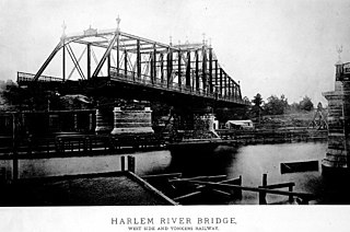
The Putnam Bridge was a swing bridge that spanned the Harlem River and the adjacent tracks of the New York Central Railroad in New York City. The bridge connected Harlem in Manhattan to Concourse, near the current location of Yankee Stadium, in the Bronx. It carried two tracks of the New York and Putnam Railroad, and later the 9th Avenue elevated line of the Interborough Rapid Transit Company (IRT), as well as two pedestrian walkways outside the superstructure.

Tibbetts Brook, originally Tippett's Brook or Tibbitt's Brook, is a stream in the southern portion of mainland New York, flowing north to south from the city of Yonkers in Westchester County into the borough of the Bronx within New York City. Originally emptying into Spuyten Duyvil Creek as part of the Harlem River system, the stream is now partially subterranean, ending above ground at the south end of Van Cortlandt Lake within Van Cortlandt Park. There it proceeds into city sewers, draining into either the northern end of the Harlem River or the Wards Island Water Pollution Control Plant. The brook provides significant watershed to both Van Cortlandt Park at its south end and Tibbetts Brook Park at its north end. There have been modern proposals to daylight the southern portion of the brook back onto the surface.
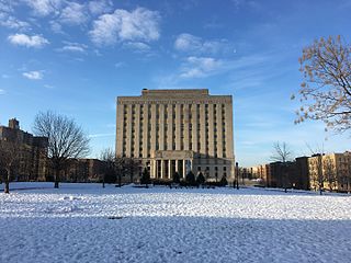
Concourse is a neighborhood in the southwestern section of the New York City borough of the Bronx which includes the Bronx County Courthouse, the Bronx Museum of the Arts, and Yankee Stadium. Its boundaries, starting from the north and moving clockwise, are East 169th Street to the north, Webster Avenue to the east, East 149th Street to the south, and Jerome Avenue and Harlem River to the west. The neighborhood is divided into three subsections: West Concourse, East Concourse, and Concourse Village with the Grand Concourse being its main thoroughfare.

Rattlesnake Creek is an underground waterway in the northeast Bronx, New York City. It flowed above ground level until the mid-20th century, with a waterfall and a pond over its course. Rattlesnake Creek has since been mostly covered over, but a small portion of it is still visible in Seton Falls Park.

