
Flushing is a neighborhood in the north-central portion of the New York City borough of Queens. The neighborhood is the fourth-largest central business district in New York City. Downtown Flushing, a major commercial and retail area centered on the intersection of Main Street and Roosevelt Avenue, is the third-busiest intersection in New York City, behind Times Square and Herald Square.
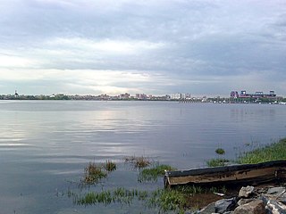
Flushing Bay is a tidal embayment in New York City. It is located on the south side of the East River and stretches to the south near the neighborhood of Flushing, Queens. It is bordered on the west by LaGuardia Airport and the Grand Central Parkway, on the south by Northern Boulevard, and on the east by the neighborhood of College Point. The Flushing River empties into the bay at its southeast corner. A 150-foot-wide navigational channel (46 m) dredged at a depth of 14 feet (4.3 m) runs along much of the bay's length.

Broadway–Flushing is a historic district and residential subsection of Flushing, Queens, New York City. The neighborhood comprises approximately 2,300 homes. It is located between 155th and 170th Streets to the west and east respectively, and is bounded on the north by Bayside and 29th Avenues, and on the south by Northern Boulevard and Crocheron Avenue. Broadway–Flushing is listed on the National Register of Historic Places.
Frederick Bowley (1851–1916) was an American politician, who served as the first executive of the Borough of Queens in New York City.

Kissena Creek is a buried stream located in the neighborhoods of Flushing, Fresh Meadows, Hillcrest, and Kew Gardens Hills in the New York City borough of Queens. Kissena Creek originates in a now-filled swamp within Kew Gardens Hills and Pomonok in central Queens, flowing east to Hillcrest. The creek then travels mostly north and west, largely flowing beneath Kissena Park Golf Course, Kissena Park, Kissena Corridor Park, and Queens Botanical Garden, before merging with the Flushing River in Flushing Meadows–Corona Park.
Berrien's Island was an island in the East River in New York City, off the northern shore of Astoria in Queens. It takes its name from Cornelius Jansen Berrien, who purchased it from Timothy Wood in 1727. He was born to John and Ruth Berrien and was married to Sarah Hallet on December 29, 1719 in Newtown, Queens. He died on Berrien's Island and was buried there. During the 20th century, Berrien's Island became connected to the larger Long Island, on which most of Queens is situated. The site is now occupied by a Consolidated Edison plant.
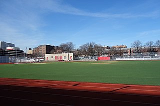
Flushing Fields is a public park in the northern section of the Flushing neighborhood of Queens in New York City. The site of this park was purchased by the Memorial Field of Flushing Corporation in 1921 at what was at the time open farmland. From its beginning, the park served as the home field for the softball, soccer, football and track teams from Flushing High School. The name of the park and monument at its southern section honor residents of Flushing killed in the First World War.

College Point Fields is a public park in College Point, Queens, New York City. It is bounded by Ulmer and 130th Streets to the west, 23rd Avenue to the north, Linden Place to the east, and 26th Avenue and the remains of Mill Creek to the south. The park contains two fields each for Little League Baseball and regular baseball; a soccer field; a roller hockey rink; and bleachers.
Vleigh Playground is a 2.243-acre park in Kew Gardens Hills, Queens, New York City. It takes its name from Head of the Vleigh Road, a colonial period path that ran along the northern boundary of the playground site. This path is presently followed by Vleigh Place and 70th Road. This road connected the town of Flushing to Brooklyn during colonial times, allowing travelers to circumvent Flushing Meadows, then an impassible swamp.
Anthony Catanzaro Square is located within a traffic triangle that is the result of three street grids that meet in the Bath Beach neighborhood of Brooklyn, New York. At this junction, West 16 Street meets its northern end at the same place where Avenue Y meets its western end, both of these roads meeting Bay 50th Street.
Horse Brook is a buried stream located in the neighborhood of Elmhurst in the New York City borough of Queens. Its historic course flows beneath Queens Center Mall, Rego Center Mall, LeFrak City, and the Long Island Expressway, before emptying into Flushing Creek in present-day Flushing Meadows-Corona Park. Flushing Creek is a tributary of the East River.
Turtle Playground, located at 138th Street and the south side of Horace Harding Expressway in Flushing, was acquired by the City of New York in 1954 as part of land condemnations for the Long Island Expressway.
Playground Seventy Five is a public park located on 160th Street and 75th Avenue in the Hillcrest neighborhood of Queens, New York. It was acquired by the New York City government in 1929 as part of land condemnations for the construction of Public School 154. The undeveloped section of the block was reserved as a schoolyard and developed as a playground in 1954.
William M. Feehan Triangle is a 0.032-acre (130 m2) public green space in the Broadway-Flushing neighborhood of Queens, New York. It is bound by Bayside Lane, 164th Street, and 27th Avenue. The triangle’s shape is the result of the street grid imposed on the once-rural landscape of Flushing in the 1920s. Bayside Lane predates the grid, cutting across its numbered streets and avenues in a diagonal path. The park is landscaped with trees and shrubs. In 2002, the New York City Council passed legislation to name the triangle for William M. Feehan.
Scott M. Kopytko Triangle is a 0.0023-acre (100 sq ft) public green space in the Flushing neighborhood of Queens, New York City. It is bound by 158th Street, Oak Avenue, and Quince Avenue. The triangle's shape is the result of two street grids intersecting with each other to form this small green space. To the park's west, streets named after plants, such as Poplar, Quince, and Rose, recall Flushing's past as America's premier horticultural center at the site of what is now Kissena Park. William Prince established the New World's first commercial nursery in Flushing 1735.
McKenna Square is a 0.24-acre public green space in the Washington Heights neighborhood of Upper Manhattan in New York City. The park is located in a median of West 165th Street, between Audubon and Amsterdam Avenues. The triangular site was created in 1917 in conjunction of the widening of West 165th Street and was transferred to Parks in 1937.

Libra Triangle is a 0.028 acres (0.011 ha) public green space located in the neighborhood of Elmhurst in Queens, New York, at the intersection of Broadway and Justice Avenue. Prior to its consolidation with New York City in 1898, Elmhurst was known as the town of Newtown. Its center of local government was at the site of this traffic triangle.

Triangle 54 is a 8,973.36-square-foot (833.652 m2) public park located in the Blissville neighborhood of Long Island City in Queens, New York City. This traffic triangle is bound by 48th Street on the southwest and east, and 54th Avenue on the north. The park contains ten trees and a memorial flagstaff in its center that dates to 1930. On its granite base is inscribed, "Erected by the citizens of Laurel Hill in memory of those who died in the World War." Laurel Hill is an old name for this area, which once had its own railroad station. The name still appears on the map in Laurel Hill Boulevard, which runs a few blocks to the north of this site.
Walter J. Wetzel Triangle is small park bound by Cohancy Street, 156th Avenue, 99th Street, and 157th Avenue, in the Howard Beach neighborhood of Queens, New York City.

Bowne Park is a 11.79-acre (4.77 ha) park in Broadway–Flushing, Queens, New York, east of downtown Flushing. It is bordered by 29th Avenue on the north, 32nd Avenue on the south, 155th Street on the west, and 159th Street on the east. The park consists of a playground, basketball courts, bocce court, and a kettle pond. The area immediately surrounding the park, developed in the late 19th and early 20th centuries, was originally also marketed as "Bowne Park" and is part of modern-day Murray Hill and Broadway–Flushing.
