Related Research Articles

Ozone Park is a neighborhood located in the southwestern section of the borough of Queens, in New York City, New York, United States. It is located next to the Aqueduct Racetrack in South Ozone Park, a popular spot for Thoroughbred racing and home to the Resorts World Casino & Hotel. Ozone Park, a diverse neighborhood, is known for its large Italian-American population.

Woodhaven is a neighborhood in the southwestern section of the New York City borough of Queens. It is bordered on the north by Park Lane South and Forest Park, on the east by Richmond Hill, on the south by Ozone Park and Atlantic Avenue, and on the west by the Cypress Hills neighborhood of Brooklyn.
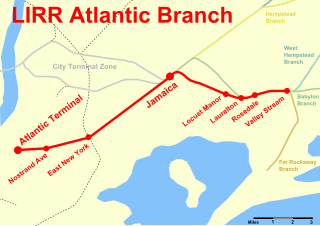
The Atlantic Branch is an electrified rail line owned and operated by the Long Island Rail Road in the U.S. state of New York. It is the only LIRR line that runs in the borough of Brooklyn.

Rockaway Boulevard is a station on the IND Fulton Street Line of the New York City Subway. Located at the intersection of Rockaway Boulevard, Woodhaven and Cross Bay Boulevards, and Liberty Avenue in Ozone Park, Queens, it is served by the A train at all times, and the S train on summer weekends.

The Far Rockaway Branch is an electrified rail line and service owned and operated by the Long Island Rail Road in the U.S. state of New York. The branch begins at Valley Interlocking, just east of Valley Stream station. From Valley Stream, the line heads south and southwest through southwestern Nassau County, ending at Far Rockaway in Queens, thus reentering New York City. LIRR maps and schedules indicate that the Far Rockaway Branch service continues west along the Atlantic Branch to Jamaica. This two-track branch provides all day service in both directions to the Atlantic Terminal in Brooklyn, with limited weekday peak service to/from Penn Station in Midtown Manhattan. During peak hours, express service may bypass Jamaica station.

80th Street is a station on the IND Fulton Street Line of the New York City Subway. Located on Liberty Avenue at 80th Street in Ozone Park, Queens, it is served by the A train at all times.

Woodhaven Boulevard is a local station on the IND Queens Boulevard Line of the New York City Subway, consisting of four tracks. Located in Elmhurst, Queens, it is served by the M train on weekdays, the R train at all times except nights, and the E train at night. The station serves the adjacent Queens Center Mall, as well as numerous bus lines.

Rockaway Park is a neighborhood in the New York City borough of Queens. The area is on the Rockaway Peninsula, nestled between Jamaica Bay to the north and the Atlantic Ocean to the south. The neighborhood of Rockaway Beach lies on its eastern border while the community of Belle Harbor is situated on its western side. The neighborhood is part of Queens Community Board 14.
Woodhaven Boulevard and Cross Bay Boulevard are two parts of a major boulevard in the New York City borough of Queens. Woodhaven Boulevard runs roughly north–south in the central portion of Queens. South of Liberty Avenue, it is known as Cross Bay Boulevard, which is the main north–south road in Howard Beach. Cross Bay Boulevard is locally known as simply "Cross Bay", and Woodhaven Boulevard, "Woodhaven". The completion of the boulevard in 1923, together with the construction of the associated bridges over Jamaica Bay, created the first direct roadway connection to the burgeoning Atlantic Ocean beachfront communities of the Rockaway Peninsula from Brooklyn and most of Queens.

Union Turnpike is a thoroughfare stretching across part of Long Island in southern New York state, mostly within central and eastern Queens in New York City. It runs from Myrtle Avenue in Glendale, Queens, to Marcus Avenue in North New Hyde Park, Nassau County, about 1 mile (1.6 km) outside New York City border. The name memorializes the Union Racetrack, once a famous attraction for Queens residents.

Rockaway Parkway is a major commercial street in the Canarsie neighborhood of Brooklyn, New York.
The Rockaway Beach Branch was a rail line owned and operated by the Long Island Rail Road in Queens, New York City, United States. The line left the Main Line at Whitepot Junction in Rego Park heading south via Ozone Park and across Jamaica Bay to Hammels in the Rockaways, turning west there to a terminal at Rockaway Park. Along the way it connected with the Montauk Branch near Glendale, the Atlantic Branch near Woodhaven, and the Far Rockaway Branch at Hammels.

Linden Boulevard is a boulevard in New York City. It starts off at Flatbush Avenue in Brooklyn as a one-way street to Caton Avenue, where it becomes a two-way boulevard, and stretches through both Brooklyn and Queens. This boulevard, especially the area of Cambria Heights between Springfield Boulevard and the Nassau County line represents a smaller version of shopping centers located on Jamaica Avenue and Queens Boulevard. Linden Boulevard also continues into Nassau County to Valley Stream where it turns into Central Avenue; this was one of several former names of the street in Queens.
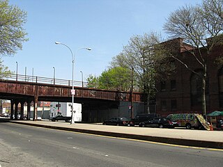
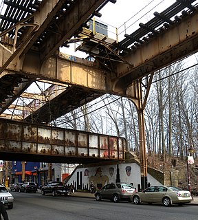
Woodhaven Junction was a station complex on the Atlantic Branch and Rockaway Beach Branch of the Long Island Rail Road, located at Atlantic Avenue between 98th and 100th Streets in Woodhaven, Queens, New York City. The elevated Rockaway Beach station was closed in 1962 along with the rest of the branch, while the underground Atlantic Branch station was closed and abandoned on January 7, 1977.

Ozone Park is a former Long Island Rail Road station in New York City. Located at 99th Street and 101st Avenue in Ozone Park, Queens, it was a major station along the Rockaway Beach Branch until the line's closure in 1962.
Brooklyn Manor was a station on the Long Island Rail Road's Rockaway Beach Branch located on the south side of Jamaica Avenue at 100th Street, straddling the border between Richmond Hill and Woodhaven in Queens, New York City. The station name referred to the nearby Brooklyn Manor section of Woodhaven, originally a 603-lot development bounded by Woodhaven Boulevard to the west, 96th/98th Streets to the east, Forest Park to the north, and Jamaica Avenue to the south. The station opened in January 1911, and was constructed as a replacement for the Brooklyn Hills station, which was located 3,000 feet (910 m) to the north. This station closed along with the rest of the Rockaway Beach Branch in 1962, and was subsequently demolished.

Rockaway Boulevard is a major road in the New York City borough of Queens. Unlike the similarly named Rockaway Beach Boulevard and Rockaway Freeway, it serves mainland Queens and does not enter the Rockaways.

The Q11, Q21, Q52, and Q53 bus routes constitute a public transit corridor running along Woodhaven and Cross Bay Boulevards in Queens, New York City. The corridor extends primarily along the length of the two boulevards through "mainland" Queens, a distance of 6 miles (9.7 km) between Elmhurst and the Jamaica Bay shore in Howard Beach. The Q52 and Q53 buses, which provide Select Bus Service along the corridor, continue south across Jamaica Bay to the Rockaway peninsula, one of the few public transit options between the peninsula and the rest of the city.
Walter J. Wetzel Triangle is small park bound by Cohancy Street, 156th Avenue, 99th Street, and 157th Avenue, in the Howard Beach neighborhood of Queens, New York City.

Macri Triangle is a 0.57 acres park located at the intersection of Meeker Avenue, Union Avenue, and Metropolitan Avenue in Williamsburg, Brooklyn, New York City. The property was designated as a park in 1946 during the construction of the Brooklyn-Queens Expressway, which resulted in the demolition of buildings along its route and the extension of Meeker Avenue from Richardson Street south to Metropolitan Avenue, serving as the expressway's service road. As the highway ran through the street grid, triangular parcels that were too small to be developed were designated as public plazas, including this one.
References
- ↑ McClarey, Donald R. “April 24, 1945: Death of Father Cyclone” April 24, 2018 The American Catholic https://www.the-american-catholic.com/2018/04/24/75442/
- ↑ “Queens Triangle Named for Priest” Brooklyn Daily Eagle Oct. 9, 1949
- ↑ Khedaroo, Jennifer “Queens triangle renamed for local priest killed in WWII” Queens Ledger March 12, 2019
- ↑ Colangelo, Lisa “Queens to rededicate memorial to priest who tended to soldiers during WWII” AM New York March 7, 2019