Related Research Articles
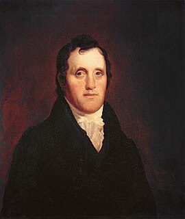
Daniel D. Tompkins was an American politician. He was the fourth governor of New York from 1807 to 1817, and the sixth vice president of the United States from 1817 to 1825.

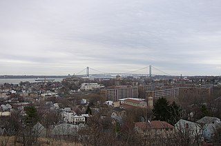
St. George is a neighborhood on the northeastern tip of Staten Island in New York City, along the waterfront where the Kill Van Kull enters Upper New York Bay. It is the most densely developed neighborhood on Staten Island, and the location of the administrative center for the borough and for the coterminous Richmond County. The St. George Terminal, serving the Staten Island Ferry and the Staten Island Railway, is also located here. St. George is bordered on the south by the neighborhood of Tompkinsville and on the west by the neighborhood of New Brighton.

Tompkinsville is a neighborhood in northeastern Staten Island in New York City. Though the neighborhood sits on the island's eastern shore, along the waterfront facing Upper New York Bay, between St. George on the north and Stapleton on the south, it is considered part of the North Shore by the island's residents.
Clifton is a neighborhood on the North Shore of Staten Island in New York City, United States. It is an older waterfront neighborhood, facing Upper New York Bay on the east. It is bordered on the north by Stapleton, on the south by Rosebank, on the southwest by Concord, and on the west by Van Duzer Street.

Stapleton Heights is a neighborhood in northeastern Staten Island, New York City. It stands on the second of a series of hills that form a "backbone" running diagonally across the island from northeast to southwest, between Ward Hill and Grymes Hill; to the east is Stapleton, which is along the waterfront. It is an upper-middle-class enclave noted for its large older one-family homes, and for its view of Upper New York Bay and the Verrazano Narrows Bridge. Many of the grander homes of the neighborhood were constructed in the late 19th century by the families who controlled the industries along the waterfront, including the breweries that operated there until the last one closed in 1963. One such home, on Louis Street, is allegedly "haunted," according to local residents.

New Brighton is a neighborhood located on the North Shore of Staten Island in New York City. The neighborhood comprises an older industrial and residential harbor front area along the Kill Van Kull west of St. George. New Brighton is bounded by Kill Van Kull on the north, Jersey Street on the east, Brighton and Castleton Avenues to the south, and Lafayette Avenue and Snug Harbor Cultural Center to the west. It is adjacent to St. George to the east, Tompkinsville to the south, and West New Brighton to the west.

The term North Shore is frequently applied to a series of neighborhoods within the New York City borough of Staten Island.
Huguenot is a neighborhood on the South Shore of Staten Island, New York City. Originally named "Bloomingview", it was later named for the Huguenots, led by Daniel Perrin, who settled in the area during the late 17th and early 18th centuries to escape religious persecution. Huguenot is bordered by Arden Heights to the north, Woodrow to the west, Prince's Bay to the south, and Annadale to the east. The neighborhood is represented in the New York City Council by Joe Borelli, who was born and raised there. Huguenot is represented in the New York State Senate by Andrew Lanza and in the New York State Assembly by Michael Reilly.
Westerleigh is a residential neighborhood in the northwestern part of Staten Island in New York City.
Willowbrook is a neighborhood in Staten Island, one of the five boroughs of New York City. It is located in the region of the island usually referred to as Mid-Island, immediately to the south of Port Richmond, to the west of Meiers Corners and Westerleigh, to the north of New Springville, and to the east of Bulls Head.
Arden Heights is a name increasingly applied to the western part of Annadale, a neighborhood located on the South Shore of Staten Island, New York, USA. The name "Arden Heights" is found on most maps of New York City, including Hagstrom's.
Woodrow is a neighborhood located on the South Shore of Staten Island, New York, United States. The neighborhood is represented in the New York State Senate by Andrew Lanza, in the New York State Assembly by Michael Reilly, and in the New York City Council by Joe Borelli.
Graniteville is the name of a neighborhood in Staten Island, one of the five boroughs of New York City.

Concord is a neighborhood located in the borough of Staten Island in New York City, New York, United States.
Ward Hill is a hill and eponymous neighborhood located in the northeastern part of Staten Island, New York City. Ward Hill is the northernmost of a chain of hills that stretch approximately halfway across Staten Island, which at one point rises to 410 feet, the highest elevation found that close to the seabord south of Maine in the eastern United States.

Brighton Heights is a neighborhood in New York City's borough of Staten Island.

Conference House Park is a park in Tottenville, Staten Island, New York City. The park is located along the Arthur Kill coast where the kill opens into Raritan Bay. It contains clay bluffs, part of the terminal moraine, formed when the Wisconsin Glacier receded 10,000 years ago. Ward's Point, the southernmost point in New York state, is in the park.
Arlington is a neighborhood on the North Shore of Staten Island in New York City. It is a subsection of the Mariners' Harbor neighborhood, located north of the North Shore Branch, and west of Harbor Road. Arlington was given its name by Civil War veteran and resident Moses Henry Leman, in recognition of Arlington National Cemetery.
Tompkins Avenue is a mostly residential yet primary east-west artery that runs through the Fort Wadsworth, Rosebank, Shore Acres, Clifton, and Stapleton neighborhoods of New York City, in the borough of Staten Island, New York.

The Special Hillsides Preservation District was created in 1987 by the City of New York to preserve the hilly terrains of the North Shore of Staten Island. The district maintains different planning rules to the rest of the City to account for the geological and bio diversity of the area. The district's goals are to reduce hillside erosion, landslides, and excessive storm-water runoff by conserving vegetation and protecting natural terrain; preserve hillsides with unique aesthetic value; protect areas of outstanding natural beauty; and protect neighborhood character.
References
- ↑ Lionel Pincus and Princess Firyal Map Division, The New York Public Library. "Sheet No. 11. [Includes New Brighton, (St. George), Tompkinsville and New York Bay.]" The New York Public Library Digital Collections. 1906 - 1913. https://digitalcollections.nypl.org/items/510d47e2-628c-a3d9-e040-e00a18064a99
- ↑ Morris, Ira K. “Morris’ Memorial History of Staten Island” 1898, chapter on Pavilion Hill. http://www.statenislandhistory.com/old-town-names.html
- ↑ "Tompkins Cir · Staten Island, NY".
- ↑ "Street dedication for Joe Marotta". Staten Island Advance. August 27, 2009. Archived from the original on January 30, 2016.
Coordinates: 40°38′09″N74°04′50″W / 40.635708°N 74.080491°W
| | This article about a location on Staten Island, New York is a stub. You can help Wikipedia by expanding it. |