Claremont Park | |
---|---|
![]() The gazebo | |
![]() | |
Coordinates | 40°50′27″N73°54′27″W / 40.84083°N 73.90750°W |
Area | 38 acres (15 ha) |
Created | 1884 |
Operated by | New York City Department of Parks and Recreation |
Status | Open all year |
Claremont Park is a park in the Morrisania section of the Bronx in New York City. The land on which the park sits was once part of the Morris family estate and was the site of the Zborowski Mansion. After becoming a municipal park in 1884 as part of the New Parks Act, the mansion was used for a time as the Bronx headquarters for the Department of Parks and was torn down in 1938.
Claremont Park is a 38-acre (15 ha) park in the Morrisania section of the Bronx. Roughly triangular, The New York Times once described as "ham-shaped". [1] The park is bordered by East Mount Eden Avenue (previously known as Belmont Street) on the north, by Morris and Teller Avenues on the west, and by East 170th Street and Clay Avenue on the east. [2] : 319 It sits atop a ridge which overlooks the modern Webster Avenue; at one time this had been Mill Brook (also known as Saw Mill Creek), which no longer exists. [2] : 289 [3]
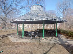
The park includes handball and basketball courts, baseball fields, playgrounds, and barbecue areas. There are also two outdoor pools; a large one for swimming, and a smaller wading pool. There is a gazebo which was built in 1938 when the Claremont Mansion was torn down. [4] One block east of Claremont Park is the .55-acre (0.22 ha) Little Claremont Playground, also known as Claremont Community Park. The playground is part of PS 42. [5]
The land which became Claremont Park was part of the Morris family estate from 1679 to 1848, when Gouverneur Morris II sold a parcel in the northern part of the property to Elliott and Anna Zborowski de Montsaulain. The couple built Claremont Mansion (later known as Zborowski Mansion) on the land in 1859, [6] establishing for the first time the name Claremont for this area. [7]
In 1884, the New Parks Act was passed, which led to the purchase of land by the city to create the 6 major parks in the borough: Claremont, Crotona, Van Cortlandt, Bronx, St. Mary's, and Pelham Bay. The Zborowski mansion was used by the Parks Department as their Bronx headquarters until it was moved to the Ranaqua section of Bronx Park. [8] In the ensuing years, additional parts of the Zborowski [note 1] estate in the vicinity of Claremont Park continued to be sold. In 1888, 110 lots were offered for sale, of which 97 were ultimately sold, for an aggregate price of $73,000. [9] A further 250 lots of the estate were sold in 1897, for $200,000. [10]
In 1889, Claremont Park, along with a nearby horse racing track called Fleetwood Park, [11] [12] was considered as a possible site for a 1892 World's Fair. [13] [14] The fair was to be the International Columbian Exposition, celebrating the 400th anniversary of Christopher Columbus finding the new world. The alternative locations in New York were Inwood, Oak Point-Barretto Point, Port Morris, Cedar Park, and Morningside Park-Riverside Park-Bloomingdale Asylum. In 1890, however, the US Congress designated Chicago as the host city for the exposition. [15]
A 1904 letter to the editor of The New York Times complained about electrical wiring having been strung through the park to bring power to the Claremont Mansion, which at that time was being used as the headquarters for the Bronx Parks Department. The writer also complained about excessive noise from the park due to sporting events and Sunday concerts. [16]
The New York Central Railroad (now known as the Harlem line of Metro North Railroad) ran 1 block east of the Zborowski estate, with a station known as Central Morrisania directly across from the property. The name was changed to Claremont Park Station on June 1, 1891. [17] The station was permanently closed in 1960. [18]
A geological oddity of Claremont Park was a small but deep lake known as the "Black Swamp", which had a reputation for swallowing up livestock. The Native Americans who lived in the area believed it to be inhabited by evil spirits. Early European settlers were also aware of the danger, erecting a fence around it to prevent cattle from falling in. [19] : 95 [20] In 1904, a project to extend Morris Avenue past Claremont Park ran into problems when a horse and cart carrying fill intended to be dumped into the lake sank into the water. It was estimated that over 60,000 cubic yards (46,000 m3) of fill were dumped into the lake before the job was finished. [19] : 95 [20]
A collapse of a porch of the mansion led to 26 people being injured in 1909. An afternoon rainstorm caused about 100 people who were in the park to seek shelter on the porch, leading to a structural collapse and the people being dropped 15 feet into a cellar. [1]
Morrisania is a residential neighborhood in the southwestern Bronx, New York City, New York. Its boundaries are the Cross-Bronx Expressway to the north, Crotona-Prospect Avenue to the east, East 163rd Street to the south, and Webster Avenue to the west. Third Avenue is the primary thoroughfare through Morrisania.
Bronx Park is a public park along the Bronx River, in the Bronx, New York City. The park is bounded by Southern Boulevard to the southwest, Webster Avenue to the northwest, Gun Hill Road to the north, Bronx Park East to the east, and East 180th Street to the south. With an area of 718 acres (2.91 km2), Bronx Park is the eighth-largest park in New York City.
College Point is a working-middle-class neighborhood in the New York City borough of Queens. It is bounded to the south by Whitestone Expressway and Flushing; to the east by 138th Street and Malba/Whitestone; to the north by the East River; and to the west by Flushing Bay. College Point is a mostly residential ethnically diverse community with some industrial areas. The neighborhood is served by several parks and contains two yacht clubs.
Crotona Park East, also known as Crotona or East Morrisania, is a residential neighborhood geographically located in the southwest Bronx in New York City. Crotona Park East is considered part of the South Bronx. Its boundaries, starting from the north and moving clockwise are the Cross-Bronx Expressway to the north, the Bronx River to the east, East 167th Street to the south, and Crotona/Prospect Avenues to the west. Southern Boulevard is the primary thoroughfare through the area. The neighborhood is adjacent to, but distinct from, the nearby park named Crotona Park.
Highbridge Park is a public park on the western bank of the Harlem River in Washington Heights, Manhattan, New York City. It stretches between 155th Street and Dyckman Street in Upper Manhattan. The park is operated by the New York City Department of Parks and Recreation. The City maintains the southern half of the park, while the northern half is maintained by the non-profit New York Restoration Project. Prominent in the park are the Manhattan end of the High Bridge, the High Bridge Water Tower, and the Highbridge Play Center.
Fort Washington Park is a public park located in the Washington Heights section of Upper Manhattan in New York City. It runs along the banks of the Hudson River next to Riverside Drive and the Henry Hudson Parkway from West 155th Street to Dyckman Street. The George Washington Bridge crosses above the park; below the bridge is a small point of land called Jeffrey's Hook, which is the site of the Little Red Lighthouse.
The West Bronx is a region in the New York City borough of the Bronx. The region lies west of the Bronx River and roughly corresponds to the western half of the borough.
Crotona Park is a public park in the South Bronx in New York City, covering 127.5 acres (51.6 ha). The park is bounded by streets of the same name on its northern, eastern, southern, and western borders, and is adjacent to the Crotona Park East and Morrisania neighborhoods of the Bronx. It is divided into four portions by Claremont Parkway and Crotona Avenue, which run through it.
The New York Park Association was formed in 1881 or 1882 by John Mullaly and other citizens. The group was concerned about urban growth. The group lobbied for the acquisition of land to create parks and parkways in New York City, and was instrumental in the passage of the New Parks Act in 1884.
Playground 52 is a 1.8-acre (0.73 ha) playground at 681 Kelly Street in the Longwood neighborhood of the Bronx, in New York City. The playground features basketball and handball courts, bathrooms, a spray shower, and a skate park. as well as an amphitheater with a large dance floor.
The Battery, formerly known as Battery Park, is a 25-acre (10 ha) public park located at the southern tip of Manhattan Island in New York City facing New York Harbor. It is bounded by Battery Place on the north, with Bowling Green to the northeast, State Street on the east, New York Harbor to the south, and the Hudson River to the west. The park contains attractions such as an early 19th-century fort named Castle Clinton; multiple monuments; and the SeaGlass Carousel. The surrounding area, known as South Ferry, contains multiple ferry terminals, including the Staten Island Ferry's Whitehall Terminal; a boat launch to the Statue of Liberty National Monument ; and a boat launch to Governors Island.
St. Mary's Park is a public park in the Mott Haven neighborhood in the South Bronx section of the Bronx, New York City. The park has sporting facilities and an indoor recreation center.
Concourse is a neighborhood in the southwestern section of the New York City borough of the Bronx which includes the Bronx County Courthouse, the Bronx Museum of the Arts, and Yankee Stadium. Its boundaries, starting from the north and moving clockwise, are East 169th Street to the north, Webster Avenue to the east, East 149th Street to the south, and Jerome Avenue and Harlem River to the west. The neighborhood is divided into three subsections: West Concourse, East Concourse, and Concourse Village with the Grand Concourse being its main thoroughfare.
The Claremont Park station was a station on the New York Central Railroad's Harlem Line in the East Morrisania neighborhood of the Bronx in New York City. The New York, New Haven and Hartford Railroad also ran through this station but did not stop here.
Sunset Park is a 24.5-acre (9.9 ha) public park in the neighborhood of Sunset Park, Brooklyn, New York City, between 41st and 44th Streets and 5th and 7th Avenues. The modern-day park contains a playground, recreation center, and pool. The recreation center and pool comprise the Sunset Play Center, which was designated as both an exterior and interior landmark by the New York City Landmarks Preservation Commission. The park is operated by the New York City Department of Parks and Recreation, also known as NYC Parks.
Calvert Vaux Park is an 85.53-acre (34.61 ha) public park in Gravesend, Brooklyn, in New York City. Created in 1934, it is composed of several disconnected sections along the Belt Parkway between Bay 44th and Bay 49th Streets. The peninsula upon which the park is located faces southwest into Gravesend Bay, immediately north of the Coney Island Creek. The park was expanded in the 1960s by waste from the construction of the Verrazzano-Narrows Bridge, and was renamed after architect Calvert Vaux in 1998. It is operated by the New York City Department of Parks and Recreation, also known as NYC Parks.
Seton Falls Park is a 36-acre (15 ha) wooded area in the Edenwald area of The Bronx in New York City. The park is named after the Seton family, who owned the land in the 19th century.
Givans Creek Woods is a 10.73-acre (4.34 ha) wooded area near Co-op City in The Bronx, New York City.
Vinmont Veteran Park is a 3.5-acre (1.4-hectare) park and playground in the Riverdale section of The Bronx. It includes bathrooms, a playground, a woodland area and the Sid Augarten baseball field. The site was acquired by New York City in 1945 and 1947 and opened as a park in 1951. Originally named the PS 81 Playground after a neighboring public school it was renamed in 1986 in honor of military veterans in the Vinmont neighborhood.
Fleetwood Park was a 19th-century harness racing (trotting) track in what is now the Morrisania section of the Bronx in New York, United States. The races held there were a popular form of entertainment, drawing crowds as large as 10,000 from the surrounding area. The one-mile (1.6 km) course described an unusual shape, with four turns in one direction and one in the other. For the last five years of operation, Fleetwood was part of trotting's Grand Circuit, one travel guide calling it "the most famous trotting track in the country".