Related Research Articles

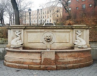
Bennett Park, also known as James Gordon Bennett Park, is a 1.8-acre (0.73 ha) public park in New York City, named for James Gordon Bennett, Sr., the newspaper publisher who launched the New York Herald in 1835. It is located between Pinehurst and Fort Washington Avenues and West 183rd and 185th Streets in the Hudson Heights neighborhood of Washington Heights in northern Manhattan, on land purchased by Bennett in 1871, the year before his death. It sits opposite the northern Fort Washington Avenue entrance to the 181st Street subway station on the IND Eighth Avenue Line, serviced by the A train.

Woodside is a residential and commercial neighborhood in the western portion of the borough of Queens in New York City. It is bordered on the south by Maspeth, on the north by Astoria, on the west by Sunnyside, and on the east by Elmhurst, Jackson Heights, and East Elmhurst. Some areas are widely residential and very quiet, while other parts, especially the ones around Roosevelt Avenue, are busier.

Queens Botanical Garden is a botanical garden located at 43-50 Main Street in Flushing, Queens, New York City. The 39-acre (16 ha) site features rose, bee, herb, wedding, and perennial gardens; an arboretum; an art gallery; and a LEED-certified Visitor & Administration Building. Queens Botanical Garden is located on property owned by the City of New York, and is funded from several public and private sources. It is operated by Queens Botanical Garden Society, Inc.

College Point is a working-middle-class neighborhood in the New York City borough of Queens. It is bounded to the south by Whitestone Expressway and Flushing; to the east by 138th Street and Malba/Whitestone; to the north by the East River; and to the west by Flushing Bay. College Point is a mostly residential ethnically diverse community with some industrial areas. The neighborhood is served by several parks and contains two yacht clubs.
Macombs Dam Park is a park in the Concourse section of the Bronx, New York City. The park lay in the shadow of the old Yankee Stadium when it stood, between Jerome Avenue and the Major Deegan Expressway, near the Harlem River and the Macombs Dam Bridge. The park is administered and maintained by the New York City Department of Parks and Recreation. The majority of Macombs Dam Park was not open to the public from August 2006, when construction began on the new Yankee Stadium, to April 2012.
Astoria Park is a 59.96-acre (24.26 ha) public park in the Astoria neighborhood of Queens in New York City. The park is situated on the eastern shore of the Hell Gate, a strait of the East River, between Ditmars Boulevard to the north and Hoyt Avenue to the south. The Triborough and Hell Gate Bridges respectively pass over the park's southern and northern sections. Astoria Park contains a playground, a soccer field, a running track, a skate park, and courts for tennis, basketball, and bocce. Astoria Park also includes the Astoria Play Center, which consists of a recreation center and a pool. The park and play center are maintained by the New York City Department of Parks and Recreation.

Bloomingdale Park is a 138-acre (56 ha) park on the South Shore of Staten Island. It is located in the Prince's Bay neighborhood, and is bounded on the north by Ramona Avenue, on the west by Bloomingdale Road, on the east by Lenevar Avenue, and on the south by Drumgoole Road West and the Korean War Veterans Parkway. It is nearly bisected by Maguire Avenue, but the avenue's two spurs into the park from the north and south do not meet in the middle.

Mapleton is a neighborhood in southern Brooklyn, New York City, bounded by 16th Avenue on the west, Dahill Road on the east, 57th Street on the north, and 65th Street on the south. It borders Bensonhurst and Borough Park to the west, and Midwood to the east.

Maria Hernandez Park is a municipal park in Bushwick, Brooklyn, New York City. It is located between Knickerbocker Avenue on the southwest to Irving Avenue on the northeast, and Starr Street on the northwest to Suydam Street on the southeast. The park is 6.87 acres (2.78 ha) and is near the Jefferson Street station of the New York City Subway.

Kissena Creek is a buried stream located in the neighborhoods of Flushing, Fresh Meadows, Hillcrest, and Kew Gardens Hills in the New York City borough of Queens. Kissena Creek originates in a now-filled swamp within Kew Gardens Hills and Pomonok in central Queens, flowing east to Hillcrest. The creek then travels mostly north and west, largely flowing beneath Kissena Park Golf Course, Kissena Park, Kissena Corridor Park, and Queens Botanical Garden, before merging with the Flushing River in Flushing Meadows–Corona Park.
Vleigh Playground is a 2.243-acre park in Kew Gardens Hills, Queens, New York City. It takes its name from Head of the Vleigh Road, a colonial period path that ran along the northern boundary of the playground site. This path is presently followed by Vleigh Place and 70th Road. This road connected the town of Flushing to Brooklyn during colonial times, allowing travelers to circumvent Flushing Meadows, then an impassible swamp.
Linden Park, officially known as Park of the Americas, is a 3.08-acre (1.25 ha) park located in the center of the Corona neighborhood of Queens, New York City. It has stood out as a green square block on maps since the village of West Flushing was first mapped out in 1853, long before the village became the suburb or urban neighborhood known as Corona.

Open Road Park is a small park in East Village, Manhattan, New York City, located east of First Avenue between 11th and 12th Streets. It is among the larger green spaces created in the East Village as a result of community organizing. The site of this park was taken over in 1993 by Open Road, a neighborhood nonprofit that developed the lot into a community garden and playground. Prior to its use as a park, the site was used for many purposes that reflect on the history of the surrounding neighborhood.
Underbridge Dog Run is a dog run named after the pedestrian bridge connecting it to the adjacent Flushing Meadows–Corona Park, the fourth-largest city-operated park in New York City and site of the 1939-40 and 1964-65 World’s Fairs. The park is located on Grand Central Parkway between 64th Avenue and 64th Road. The section of the park located opposite the Underbridge Dog Run contains Meadow Lake, the largest lake within New York City.
Turtle Playground, located at 138th Street and the south side of Horace Harding Expressway in Flushing, was acquired by the City of New York in 1954 as part of land condemnations for the Long Island Expressway.
Travis Triangle is a narrow green space in the Murray Hill/Flushing neighborhoods of Queens, New York City. It is formed by the separation of Murray Street and Murray Lane, both of which were named after the Murray family, which owned land on the site of these streets from the late colonial period through the early 19th century. In 1932, New York City's Board of Aldermen passed a resolution to name this site Travis Triangle in honor of local American Civil War veteran Ira Underhill Travis (1839-1921), who fought under the name Ira Wilson, in the 11th New York Volunteer Infantry Regiment also known as Colonel Elmer E. Ellsworth’s Zouaves.
Playground Seventy Five is a public park located on 160th Street and 75th Avenue in the Hillcrest neighborhood of Queens, New York. It was acquired by the New York City government in 1929 as part of land condemnations for the construction of Public School 154. The undeveloped section of the block was reserved as a schoolyard and developed as a playground in 1954.

Triangle 54 is a 8,973.36-square-foot (833.652 m2) public park located in the Blissville neighborhood of Long Island City in Queens, New York City. This traffic triangle is bound by 48th Street on the southwest and east, and 54th Avenue on the north. The park contains ten trees and a memorial flagstaff in its center that dates to 1930. On its granite base is inscribed, "Erected by the citizens of Laurel Hill in memory of those who died in the World War." Laurel Hill is an old name for this area, which once had its own railroad station. The name still appears on the map in Laurel Hill Boulevard, which runs a few blocks to the north of this site.

Heckscher Playground is a play area located in New York City's Central Park, located close to Central Park South between Sixth Avenue and Seventh Avenue. It is the oldest and largest of Central Park's 22 playgrounds.

Bowne Park is a 11.79-acre (4.77 ha) park in Broadway–Flushing, Queens, New York, east of downtown Flushing. It is bordered by 29th Avenue on the north, 32nd Avenue on the south, 155th Street on the west, and 159th Street on the east. The park consists of a playground, basketball courts, bocce court, and a kettle pond. The area immediately surrounding the park, developed in the late 19th and early 20th centuries, was originally also marketed as "Bowne Park" and is part of modern-day Murray Hill and Broadway–Flushing.
References
- "Offer Playground to City for Tax Aid" New York Times April 13, 1930
- "Taxes Heavy, Group Offers Land to City" Brooklyn Daily Eagle April 13, 1930

