
Battery Park City is a mainly residential 92-acre (37 ha) planned community and neighborhood on the west side of the southern tip of the island of Manhattan in New York City. It is bounded by the Hudson River on the west, the Hudson River shoreline on the north and south, and the West Side Highway on the east. The neighborhood is named for the Battery, formerly known as Battery Park, located directly to the south.

Times Square is a major commercial intersection, tourist destination, entertainment hub, and neighborhood in Midtown Manhattan, New York City. It is formed by the junction of Broadway, Seventh Avenue, and 42nd Street. Together with adjacent Duffy Square, Times Square is a bowtie-shaped space five blocks long between 42nd and 47th Streets.

Lower Manhattan, also known as Downtown Manhattan or Downtown New York City, is the southernmost part of Manhattan, the central borough for business, culture, and government in New York City, which is the most populated city in the United States with over 8.8 million residents as of the 2020 census.

Downtown Brooklyn is the third largest central business district in New York City, and is located in the northwestern section of the borough of Brooklyn. The neighborhood is known for its office and residential buildings, such as the Williamsburgh Savings Bank Tower and the MetroTech Center office complex.

Foley Square, also called Federal Plaza, is a street intersection in the Civic Center neighborhood of Lower Manhattan, New York City, which contains a small triangular park named Thomas Paine Park. The space is bordered by Worth Street to the north, Centre Street to the east, and Lafayette Street to the west, and is located south of Manhattan's Chinatown and east of Tribeca. It was named after a prominent Tammany Hall district leader and local saloon owner, Thomas F. "Big Tom" Foley (1852–1925).

St. Nicholas Avenue is a major street that runs obliquely north-south through several blocks between 111th and 193rd Streets in the New York City borough of Manhattan. The route, which follows a course that is much older than the grid pattern of the Commissioners' Plan of 1811, passes through the neighborhoods of Harlem, Hamilton Heights, and Washington Heights. It is believed to follow the course of an old Indian trail that became an important road in the 17th century between the Dutch settlement of New Amsterdam and the British New England Colonies. In the post colonial era, it became the western end of the Boston Post Road. The road became a street when row housing was being built in Harlem during its rapid urban expansion following the end of the American Civil War.

The Civic Center is the area and neighborhood of Lower Manhattan, Manhattan, New York City, that encompasses New York City Hall, One Police Plaza, the courthouses in Foley Square, the Metropolitan Correctional Center and the surrounding area. The district is bound on the west by Tribeca at Broadway, on the north by Chinatown at Worth Street or Bayard Street, on the east by the East River and the Brooklyn Bridge at South Street, and on the south by the Financial District at Ann Street.

50th Street is a street in the New York City borough of Manhattan. The street runs eastbound from 12th Avenue, across the full width of the island, ending at Beekman Place and carries the M50 bus line, which returns on 49th Street. The following subway stations serve the street, west to east:

Chambers Street is a two-way street in the New York City borough of Manhattan. It runs from River Terrace, Battery Park City in the west, past PS 234, The Borough of Manhattan Community College, and Stuyvesant High School, to the Manhattan Municipal Building at 1 Centre Street in the east. Between Broadway and Centre Street, Chambers Street forms the northern boundary of the grounds surrounding New York City Hall and the Tweed Courthouse. Opposite the Tweed Courthouse sits the Surrogate's Courthouse for Manhattan. 280 Broadway the Marble Palace, lies west of there, on the north side of Chambers.
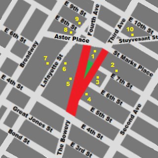
Cooper Square is a junction of streets in Lower Manhattan in New York City located at the confluence of the neighborhoods of Bowery to the south, NoHo to the west and southwest, Greenwich Village to the west and northwest, the East Village to the north and east, and the Lower East Side to the southeast.
51st Street is a 1.9-mile (3.1 km) long one-way street traveling east to west across Midtown Manhattan.

Jackson Square Park is an urban park in the Greenwich Village Historic District in Manhattan, New York City, United States. The 0.227 acres (920 m2) park is bordered by 8th Avenue on the west, Horatio Street on the south, and Greenwich Avenue on the east. The park interrupts West 13th Street.

Peter Minuit Plaza is an urban square serving the intermodal transportation hub at South Ferry, and lies at the intersection of State Street and Whitehall Street in the Financial District of Lower Manhattan. The plaza is a heavy pedestrian traffic area just north of the Staten Island Ferry Whitehall Terminal and includes two exits for the New York City Subway's South Ferry/Whitehall Street station as well as the M15 SBS South Ferry Bus Loop at Peter Minuit Place, making this a busy intersection that is used by approximately 70,000 residents and visitors daily.

The West Street pedestrian bridges are a series of pedestrian bridges that cross West Street to connect the neighborhoods of Tribeca and the Financial District with Battery Park City in Lower Manhattan, New York City. The bridges were built to provide alternatives to crossing the busy street. Prior to the September 11 attacks, there were three bridges at Chambers Street, Vesey Street and Liberty Street. The Vesey Street and Liberty Street bridges connected the former World Trade Center complex with the World Financial Center.

Vietnam Veterans Plaza is an American memorial plaza in Manhattan, New York. It honors New York City citizens who served during the 20th-century Vietnam War.

Elizabeth H. Berger Plaza is a public park in the Financial District of Manhattan, New York City. formed by the triangular junction of Trinity Place, Greenwich Street and Edgar Street. It faces the Manhattan exit ramp from the Brooklyn–Battery Tunnel. Formerly known as the Edgar Street Greenstreet, this park honors civic advocate Elizabeth H. Berger (1960-2013). In her role as president of the Downtown Alliance, she advocated for the fusion of two traffic triangles at this location into an expanded park. The park is located on the site of a former neighborhood known as Little Syria, a bustling immigrant community displaced by the construction of the tunnel in 1953.
Albany Street is a short street in the Financial District of Lower Manhattan in New York City. The street runs west-to-east from the Battery Park City Esplanade along the Hudson River to Greenwich Street, passing through South End Avenue and West Street on the way. The street has a walkway connection to the Rector Street Bridge which crosses West Street.

Cortlandt Street is a west-east street in the Financial District of Lower Manhattan, New York City. It runs one block from Broadway to Church Street, then continues an additional block as the non-vehicular Cortlandt Way from Church to Greenwich Street. At its eastern end, the street continues as Maiden Lane.

