Park Row (Manhattan)

Last updated

Template:Attached KML/Park Row (Manhattan)
KML is from Wikidata
Park Row
15 Park Row 3.JPG
Coordinates 40°42′40″N74°0′30″W / 40.71111°N 74.00833°W / 40.71111; -74.00833
West end Broadway/Vesey Street/Ann Street
East end Chatham Square

Park Row is a street located in the Financial District, Civic Center, and Chinatown neighborhoods of the New York City borough of Manhattan. The street runs east-west, sometimes called north-south because the western end is nearer to the Financial District. At the north end of Park Row is the confluence of Bowery, East Broadway, St. James Place, Oliver Street, Mott Street, and Worth Street at Chatham Square. At the street's south end, Broadway, Vesey Street, Barclay Street, and Ann Street intersect. The intersection includes a bus turnaround loop designated as Millennium Park.

Contents

Park Row was once known as Chatham Street; it was renamed Park Row in 1886, a reference to the fact that it faces City Hall Park, the former New York Common.

History

18th century

Printing House Square, 1866 Printing-House Square, New York MET DP280930 (cropped).jpg
Printing House Square, 1866
Printing House Square, 1868 Printing House Square, New York City.png
Printing House Square, 1868
Park Row buildings in the early 20th century (from bottom left clockwise) are: New York City Hall; the New York World Building, also known as the Pulitzer Building (with spherical top) which housed the New York World newspaper and is now the site of one of the Brooklyn Bridge entrance ramps; the New Yorker Staats-Zeitung (later demolished); the New York Tribune Building with the spire top, the present-day site of the Pace Plaza complex of Pace University); the New York Times Building, the 19th century headquarters of The New York Times and currently Pace University building; the American Tract Society Building, visible behind the Times Building; and, cut off from the picture, the Potter Building. ParkRow.jpg
Park Row buildings in the early 20th century (from bottom left clockwise) are: New York City Hall; the New York World Building, also known as the Pulitzer Building (with spherical top) which housed the New York World newspaper and is now the site of one of the Brooklyn Bridge entrance ramps; the New Yorker Staats-Zeitung (later demolished); the New York Tribune Building with the spire top, the present-day site of the Pace Plaza complex of Pace University); the New York Times Building, the 19th century headquarters of The New York Times and currently Pace University building; the American Tract Society Building, visible behind the Times Building; and, cut off from the picture, the Potter Building.

In the late 18th century Eastern Post Road became the more important road connecting New York City to Albany and New England to its north. This section of the road which became Park Row was called Chatham Street, [1] a name that enters into the city's history on numerous occasions.

The tobacco industry in New York City got its start in 1760, when Pierre Lorillard opened a snuff factory on Chatham Street, [2] and in 1795, the Long Room of Abraham Martling's Tavern on Chatham Street was one of the first headquarters used by the Tammany Society and the Democratic-Republican Party, founded by Thomas Jefferson, on election days. Those who gathered there became known as "Martling Men", "Tammanyites" or "Bucktails", especially during the time that Tammany was attempting to wrest control of the party away from governor De Witt Clinton. [3] In the 1780s, Chatham Street was the site of the Tea Water Pump, a privately owned company which took water from Fresh Water Pond, the city's only supply of fresh water, and which remained purer longer than some of the other sources which drew from the pond. [4]

Chatham Street was also a center for entertainment. In 1798, Marc Isambard Brunel designed the 2,000-seat Park Theater on Chatham Street, intended to attract the upper classes of the city. The theater cost $130,000 to build, and tickets were 25 cents for seats in the gallery, and 50 cents in the orchestra. In the early 1800s, more taverns, theaters and small hotels on the street started to offer free entertain to attract customers to drink. These were called "free and easies", "varieties" or "vaudeville" and offered numerous different kinds of performances: comedy, dance, dramatic skits, magic, music, ventriloquism, and tellers of tall tales. New theaters such as the Chatham Theater sprang up as well to attract the overflow from the entertainment strip on the Bowery. [5] Boxing was also a popular entertainment. The Arena on Park Row packed in fans with its nightly presentation of "the manly art". [6]

19th century

Ernst Plassman's statue of Benjamin Franklin, built in 1872 Benjamin Franklin statue by Ernst Plassman (1872).jpg
Ernst Plassman's statue of Benjamin Franklin, built in 1872

In the early 19th century, most of the Manhattan portion of the street was suppressed, the Commons became City Hall Park, and the stub of a street was renamed Park Row. [7] By the mid-19th century, the street had a bazaar-like atmosphere from the many used clothing shops and pawnbrokerages open by recently immigrated Jews from Germany and central Europe. This gave rise to anti-Semitic caricatures, although many New Yorkers could not distinguish German Jews from other Germans. [8] Chatham Street was also the site of several anti-African American incidents, as in the 1863 New York City draft riots, during which rioters were repulsed in their attempt to attack black waiters at Crook's Restaurant on the street. [9] Poverty was also commonplace; in 1890, Jacob Riis revealed in How the Other Half Lives that over 9,000 homeless men lodged nightly on Chatham Street and the Bowery, between City Hall and Cooper Union. [10]

During the late 19th century, Park Row was nicknamed Newspaper Row, as most of New York City's newspapers located on the street to be close to City Hall. [11] Among the earlier newspapers in the area were The New York Times , [12] :3 which in 1857 became the first New York City newspaper to be housed in a structure built specially for its use. [13] Part of the southern section of the street, centered on the intersection with Spruce Street, was known as Printing House Square. The newspapers housed on Newspaper Row, combined, printed more than 250,000 copies per day at their peak, leading the area to be considered "America's preeminent press center". [14] Other papers, such as the New York Herald and The Sun , were near Newspaper Row but not actually housed on Park Row itself. [14]

The newspapers on Chatham Street were among the first to construct early skyscrapers for their headquarters, reflecting their newfound wealth. [14] [15] :27 The first of these major newspaper buildings, the New York Tribune Building, opened in 1875 as a nine-story, 260-foot (79 m) structure; the headquarters of the New-York Tribune was then the city's second-tallest building after Trinity Church. [16] [17]

After the construction of the Brooklyn Bridge in 1883, Park Row was the site of the large Park Row Terminal for the elevated trains and cable-hauled shuttle cars which crossed the bridge. Service was gradually reduced from 1913 to 1940, and the terminal was demolished in 1944. [18]

The next major structure to open was a new headquarters for The New York Times at 41 Park Row, which was completed in 1889 and stood 13 stories tall. [19] [12] :4 The third early skyscraper on Newspaper Row was the 20-story New York World Building, the New York World 's headquarters, which at a height of 309 feet (94 m) was the first building in the city to be taller than Trinity Church. [20] The Times and Tribune Buildings were both expanded in the first decade of the 20th century. [12] :6 [21]

Two other buildings on Park Row were also part of Newspaper Row but not built specifically for newspapers' use. The Potter Building, at 38 Park Row, contained tenants such as The Press, a Republican Party-affiliated penny paper, as well as The New York Observer . [22] The Park Row Building, at 15 Park Row, housed the early headquarters of the Associated Press, founded by Moses Yale Beach. [23] [24]

The Revolution , a newspaper established by women's rights activists Susan B. Anthony and Elizabeth Cady Stanton was also headquartered on Park Row, at 27 Chatham Street. [25]

The decline of Park Row as a newspaper hub began in 1895, when the Herald moved to Herald Square. [14]

20th century

Ten years later, in 1905, the Times moved to its new headquarters at One Times Square. [26] The Tribune moved uptown in 1923, [27] while the World shuttered in 1931. [20] The Journal of Commerce , the last remaining newspaper to publish from Park Row, moved from its headquarters in the World Building in 1953. [28]

Until 1971, Park Row continued in a relatively straight path, except for a curved portion around the Brooklyn Bridge's ramps. [29] Between 1971 and 1973, a pedestrian plaza was built as part of 1 Police Plaza, after which Park Row was rerouted underneath the plaza and its intersection with New Chambers Street and Duane Street was eliminated. [30]

Today, a statue of Benjamin Franklin by Ernst Plassman stands in Printing House Square, in front of the One Pace Plaza and 41 Park Row buildings of Pace University, holding a copy of his Pennsylvania Gazette , a reminder of what Park Row once was. [31] [32]

Structures

The New York Times was originally located at 113 Nassau Street in 1851. It moved to 138 Nassau Street in 1854, and in 1858 it moved a little more than one block away to 41 Park Row, possibly making it the first newspaper in New York City housed in a building built specifically for its use. [13] The New York Times Building, which was designed by George B. Post, was designated a New York City landmark in 1999. [33] The building is now used by Pace University. [34]

The New Yorker Staats-Zeitung moved to its own building at 17 Chatham Street at almost the same time as the Times moved into its new building. [35] [36]

The Park Row Building (also known as 15 Park Row) is located at the western end of Park Row, opposite City Hall Park. Designed by noted architect R. H. Robertson, and built in 1896-99, It was designated a city landmark in 1999. [33] At 391 feet (119 m) tall it was the tallest building in the world from 1899 until 1908, when it was surpassed by the Singer Building. [37]

The Potter Building at 38 Park Row (145 Nassau Street) was built in 1882-86 and designated a New York City landmark in 1996. It was built after the owner's previous building on the site burned down. The Potter Building was converted into apartments between 1979 and 1981. [33]

The New York City Police Department is headquartered at 1 Police Plaza located on Park Row, across the street from the Manhattan Municipal Building [38] and Metropolitan Correctional Center.

Two apartment buildings of significance on Park Row are the Chatham Towers at no. 170, built in 1965 and designed by Kelly & Gruzen, which, according to the AIA Guide to New York City , makes a "strong architectural statement...[which] rouses great admiration and great criticism," and Chatham Green at 185 Park Row, built in 1961 and also designed by Kelly & Gruzen. [39]


City Hall and Park Row (1911); the Brooklyn Bridge Park Row terminal can be seen at the right Park Row and City Hall Park LCCN2007662372.tif
City Hall and Park Row (1911); the Brooklyn Bridge Park Row terminal can be seen at the right

Police Plaza closure

The segment of Park Row between Frankfort Street and Chatham Square is open only to MTA buses and government and emergency vehicles and has been closed to civilian traffic since the September 11, 2001, attacks. [38] The NYPD asserts that this is necessary to protect its headquarters from a truck bomb attack. Nearby Chinatown residents were increasingly frustrated at the disruption caused by the closure of the thoroughfare, argue that the police department has placed a chokehold on an entire neighborhood and suggest One Police Plaza be moved from a residential area. [40] Members of the Civic Center Residents Coalition fought the security perimeter around One Police Plaza for years. Park Row reopened for foot traffic and MTA buses in 2005, [41] although only 200 buses per day were allowed on the street, and they had to pass through security checkpoints. [42]

In 2007, the NYPD stated that it would not be moving despite the numerous complaints from residents, explaining that they had tried to alleviate the impact of the security measures by forbidding officers from parking in nearby public spaces and by reopening a stairway that skirts the headquarters' south side and leads down to street level near the Brooklyn Bridge. The department also planned to redesign its guard booths and security barriers to make them more attractive, and was involved in efforts to convert two lanes of Park Row into a cycling and pedestrian greenway, [38] which opened in June 2018. [43]

Related Research Articles

<span class="mw-page-title-main">Broadway (Manhattan)</span> Avenue in New York

Broadway is a road in the U.S. state of New York. Broadway runs from State Street at Bowling Green for 13 mi (20.9 km) through the borough of Manhattan, over the Broadway Bridge, and 2 mi (3.2 km) through the Bronx, exiting north from New York City to run an additional 18 mi (29.0 km) through the Westchester County municipalities of Yonkers, Hastings-On-Hudson, Dobbs Ferry, Irvington, Tarrytown, and Sleepy Hollow, after which the road continues, but is no longer called "Broadway".

<span class="mw-page-title-main">42nd Street (Manhattan)</span> West-east street in Manhattan, New York

42nd Street is a major crosstown street in the New York City borough of Manhattan, spanning the entire breadth of Midtown Manhattan, from Turtle Bay at the East River, to Hell's Kitchen at the Hudson River on the West Side. The street hosts some of New York's best known landmarks, including the headquarters of the United Nations, the Chrysler Building, Grand Central Terminal, the New York Public Library Main Branch, Times Square, and the Port Authority Bus Terminal.

<span class="mw-page-title-main">Seagram Building</span> Office skyscraper in Manhattan, New York

The Seagram Building is a skyscraper at 375 Park Avenue, between 52nd and 53rd Streets, in the Midtown Manhattan neighborhood of New York City. Designed by Ludwig Mies van der Rohe along with Philip Johnson, Ely Jacques Kahn, and Robert Allan Jacobs, the high-rise tower is 515 feet (157 m) tall with 38 stories. The International Style building, completed in 1958, initially served as the headquarters of the Seagram Company, a Canadian distiller.

<span class="mw-page-title-main">Union Square, Manhattan</span> Intersection and neighborhood in New York City

Union Square is a historic intersection and surrounding neighborhood in Manhattan, New York City, United States, located where Broadway and the former Bowery Road – now Fourth Avenue – came together in the early 19th century. Its name denotes that "here was the union of the two principal thoroughfares of the island". The current Union Square Park is bounded by 14th Street on the south, 17th Street on the north, and Union Square West and Union Square East to the west and east respectively. 17th Street links together Broadway and Park Avenue South on the north end of the park, while Union Square East connects Park Avenue South to Fourth Avenue and the continuation of Broadway on the park's south side. The park is maintained by the New York City Department of Parks and Recreation.

<span class="mw-page-title-main">23rd Street (Manhattan)</span> West-east street in Manhattan, New York

23rd Street is a broad thoroughfare in the New York City borough of Manhattan, one of the major two-way, east-west streets in the borough's grid. As with Manhattan's other "crosstown" streets, it is divided into its east and west sections at Fifth Avenue. The street runs from Avenue C and FDR Drive in the east to Eleventh Avenue in the west.
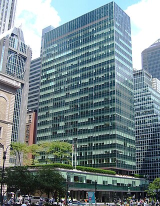
<span class="mw-page-title-main">Pearl Street (Manhattan)</span> Street in Manhattan, New York

Pearl Street is a street in the Financial District in Lower Manhattan, running northeast from Battery Park to the Brooklyn Bridge with an interruption at Fulton Street, where Pearl Street's alignment west of Fulton Street shifts one block south of its alignment east of Fulton Street, then turning west and terminating at Centre Street.
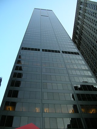
<span class="mw-page-title-main">New York World Building</span> Former skyscraper in Manhattan, New York

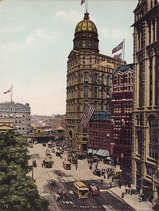
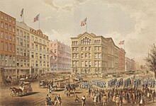
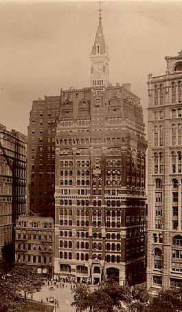
The New York World Building was a building in the Civic Center of Manhattan in New York City, along Park Row between Frankfort Street and the Brooklyn Bridge. Part of Lower Manhattan's former "Newspaper Row", it was designed by George B. Post in the Renaissance Revival style, serving as the headquarters of the New York World after its completion in 1890. The New York World Building was the tallest building in New York City upon completion, becoming the first to overtop Trinity Church, and was by some accounts the world's tallest building.

<span class="mw-page-title-main">Whitehall Street</span> Street in Manhattan, New York

Whitehall Street is a street in the South Ferry/Financial District neighborhood of Lower Manhattan in New York City, near the southern tip of Manhattan Island. The street begins at Bowling Green to the north, where it is a continuation of the southern end of Broadway. Whitehall Street stretches four blocks to the southern end of FDR Drive, adjacent to the Staten Island Ferry's Whitehall Terminal, on landfill beyond the site of Peter Stuyvesant's 17th-century house.

<span class="mw-page-title-main">1 Police Plaza</span> New York City police headquarters

One Police Plaza is the headquarters of the New York City Police Department (NYPD). The building is located on Park Row in Civic Center, Manhattan near New York City's City Hall and the Brooklyn Bridge. Its block borders Park Row, Pearl Street, and Police Plaza. 1PP replaced the NYPD's previous headquarters at 240 Centre Street, approximately 1 mile (1.6 km) north of 1 Police Plaza.

<span class="mw-page-title-main">Manhattan Municipal Building</span> Office skyscraper in Manhattan, New York

The David N. Dinkins Municipal Building is a 40-story, 580-foot (180 m) building at 1 Centre Street, east of Chambers Street, in the Civic Center neighborhood of Manhattan in New York City. The structure was built to accommodate increased governmental space demands after the 1898 consolidation of the city's five boroughs. Construction began in 1909 and continued through 1914 at a total cost of $12 million.

<span class="mw-page-title-main">Civic Center, Manhattan</span> Neighborhood of Manhattan in New York City

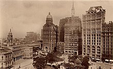
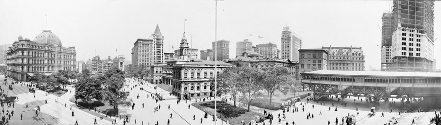
The Civic Center is an area and neighborhood in Lower Manhattan, Manhattan, New York City, that encompasses New York City Hall, One Police Plaza, the courthouses in Foley Square, the Metropolitan Correctional Center, and the surrounding area. The district is bound on the west by Tribeca at Broadway, on the north by Chinatown at Worth Street or Bayard Street, on the east by the East River and the Brooklyn Bridge at South Street, and on the south by the Financial District at Ann Street.

<span class="mw-page-title-main">270 Park Avenue (1960–2021)</span> Former building in Manhattan, New York

270 Park Avenue, also the JPMorgan Chase Tower and Union Carbide Building, was a skyscraper in the Midtown Manhattan neighborhood of New York City. Built in 1960 for chemical company Union Carbide, it was designed by architects Gordon Bunshaft and Natalie de Blois of Skidmore, Owings & Merrill (SOM). The 52-story, 707 ft (215 m) skyscraper later became the global headquarters for JPMorgan Chase. When it was demolished in 2021, the Union Carbide Building was the tallest peacefully demolished building in the world. A taller skyscraper with the same address, to be completed in 2025, is being constructed on the site.

<span class="mw-page-title-main">Stone Street (Manhattan)</span> Street in Manhattan, New York

Stone Street is a short street in the Financial District of Manhattan in New York City. It runs in two sections between Whitehall Street in the west and Hanover Square in the east. The street originally was one continuous roadway from Whitehall Street to Hanover Square, but the section between Broad Street and Coenties Alley was eliminated in 1980 to make way for the Goldman Sachs building at 85 Broad Street. The one-block-long western section between Whitehall and Broad Streets carries vehicular traffic, while the two-block-long eastern section between Coenties Alley and Hanover Square is a pedestrian zone.

<span class="mw-page-title-main">Maiden Lane (Manhattan)</span> Street in Manhattan, New York

Maiden Lane is an east–west street in the Financial District of the New York City, New York, United States borough of Manhattan. Its eastern end is at South Street, near the South Street Seaport, and its western end is at Broadway near the World Trade Center site, where it becomes Cortlandt Street.

<span class="mw-page-title-main">New York Times Building (41 Park Row)</span> Office building in Manhattan, New York

41 Park Row, also 147 Nassau Street and formerly the New York Times Building, is an office building in the Financial District of Manhattan in New York City, across from City Hall and the Civic Center. It occupies a plot abutting Nassau Street to the east, Spruce Street to the north, and Park Row to the west. The building, originally the headquarters of The New York Times, is the oldest surviving structure of Lower Manhattan's former "Newspaper Row" and has been owned by Pace University since 1951.

<span class="mw-page-title-main">City Pier A</span> Pier in Manhattan, New York

Pier A, also known as City Pier A, is a pier in the Hudson River at Battery Park in Lower Manhattan, New York City. It was built from 1884 to 1886 as the headquarters of the New York City Board of Dock Commissioners and the New York City Police Department (NYPD)'s Harbor Department. Pier A, the only remaining masonry pier in New York City, contains a two- and three-story structure with a clock tower facing the Hudson River. The pier is a New York City designated landmark and is listed on the National Register of Historic Places (NRHP).

<span class="mw-page-title-main">Potter Building</span> Building in New York City

The Potter Building is a building in the Financial District of Manhattan in New York City. The building occupies a full block along Beekman Street with the addresses 38 Park Row to its west and 145 Nassau Street to its east. It was designed by Norris G. Starkweather in a combination of the Queen Anne and neo-Grec styles, as an iron-framed structure.

<span class="mw-page-title-main">Church Missions House</span> Historic building in Manhattan, New York

Church Missions House is a historic building at Park Avenue South and East 22nd Street in the Gramercy Park neighborhood of Manhattan in New York City. Part of an area once known as "Charity Row", the building was designed by Robert W. Gibson and Edward J. Neville Stent, with a steel structure and medieval-inspired facade. The design was inspired by the town halls of Haarlem and medieval Amsterdam. Church Missions House is so named because it was the headquarters of the Episcopal Church's Domestic and Foreign Missionary Society for much of the 20th century.

<span class="mw-page-title-main">New York Tribune Building</span> Former skyscraper in Manhattan, New York

The New York Tribune Building was a building in the Financial District of Manhattan in New York City, across from City Hall and the Civic Center. It was at the intersection of Nassau and Spruce Streets, at 154 Printing House Square. Part of Lower Manhattan's former "Newspaper Row", it was the headquarters of the New-York Tribune from 1875 to 1923.

<span class="mw-page-title-main">150 Nassau Street</span> Residential building in Manhattan, New York

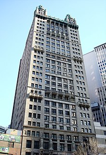
150 Nassau Street, also known as the Park Place Tower and the American Tract Society Building, is a 23-story, 291-foot (89 m) building in the Financial District of Lower Manhattan in New York City. It is located at the southeast corner of Spruce Street and Nassau Street, next to 8 Spruce Street, the former New York Times Building, and New York City Hall.

References

Notes

  1. Staff (June 22, 1893). "Outrages by 'Pullers in'" (PDF). The New York Times . p. 2. About forty years ago the original Harris Cohen established a second-hand clothing store at the corner of Baxter Street and Park Row (then Chatham Street).
  2. Burrows & Wallace (1999), p.1046
  3. Burrows & Wallace (1999), pp.322,424
  4. Burrows & Wallace (1999), p.360
  5. Burrows & Wallace (1999), pp.375,404,642
  6. Burrows & Wallace (1999), p.755
  7. Feirstein, Sanna (2001). Naming New York: Manhattan Places & How They Got Their Names. New York: New York University Press. p. 39. ISBN   978-0-8147-2712-6.
  8. Burrows & Wallace (1999), pp.740,749
  9. Burrows & Wallace (1999), p.890
  10. Burrows & Wallace (1999), p.1182
  11. Shepard, Richard F. (March 20, 1987). "Seeing the Evolution of New York City Through Artists' Eyes". The New York Times. ISSN   0362-4331 . Retrieved September 27, 2020.
  12. 1 2 3 "(Former) New York Times Building" (PDF). New York City Landmarks Preservation Commission. March 16, 1999. Retrieved September 27, 2020.
  13. 1 2 Dunlap, David W. (November 14, 2001). "150th Anniversary: 1851–2001; Six Buildings That Share One Story". The New York Times. ISSN   0362-4331 . Retrieved July 14, 2020.
  14. 1 2 3 4 "Excelsior Steam Power Company Building" (PDF). New York City Landmarks Preservation Commission. December 13, 2016. p. 4. Retrieved September 27, 2020.
  15. "Fulton–Nassau Historic District" (PDF). National Register of Historic Places, National Park Service. September 7, 2005. Retrieved September 27, 2020.
  16. "The Tribune's New Home". New-York Tribune. April 10, 1875. pp.  9, 12 via newspapers.com Open Access logo PLoS transparent.svg .
  17. Gray, Christopher (May 3, 2012). "Black and White and Red All Over". The New York Times. ISSN   0362-4331 . Retrieved September 22, 2020.
  18. Sparberg, Andrew "Park Row" in Jackson, Kenneth T., ed. (2010). The Encyclopedia of New York City (2nd ed.). New Haven: Yale University Press. p. 977. ISBN   978-0-300-11465-2.
  19. "A Newspaper at Home; "the Times" at Last in Its New Quarters. the Rooms Where Its Business Is to Be Conducted and Editorial and Mechanical Work Performed". The New York Times. April 8, 1889. ISSN   0362-4331 . Retrieved July 15, 2020.
  20. 1 2 Federal Writers' Project (1939). New York City Guide. New York: Random House. p. 99. ISBN   978-1-60354-055-1. (Reprinted by Scholarly Press, 1976; often referred to as WPA Guide to New York City.)
  21. "The Tribune Buildings". New-York Tribune. February 3, 1907. pp.  60, 61, 62, 63 via newspapers.com Open Access logo PLoS transparent.svg .
  22. King, M. (1892). King's Handbook of New York City: An Outline History and Description of the American Metropolis. Moses King. p. 778. Retrieved March 24, 2020.
  23. Beach, Stanley, Archives at Yale, Stanley Yale Beach papers, Number: GEN MSS 802, 1911-1948
  24. "Park Row Building" (PDF). New York City Landmarks Preservation Commission. June 15, 1999. p. 5. Retrieved September 27, 2020.
  25. "The Revolution" Lewis & Clark Digital Collections, Aubrey R. Watzek Library, Lewis & Clark College
  26. "A Year in the Times Building". The New York Times. December 31, 1905. ISSN   0362-4331 . Retrieved July 17, 2020.
  27. "Tribune Goes Uptown". Brooklyn Times Union. April 15, 1923. p. 14. Retrieved September 27, 2020 via newspapers.com Open Access logo PLoS transparent.svg .
  28. "Last Newspaper Is Moving Out Of Parle Row: The Journal of Commerce' Leaves 'World' Building for Varick St. Quarters" . New York Herald Tribune. February 20, 1953. p. 17. Retrieved September 25, 2020 via ProQuest.
  29. "New Brooklyn Bridge Car Routes". The New York Times. July 6, 1971. ISSN   0362-4331 . Retrieved May 18, 2020.
  30. Goldberger, Paul (October 27, 1973). "New Police Building". The New York Times. ISSN   0362-4331 . Retrieved May 18, 2020.
  31. "Historical Sign Listings". New York City Department of Parks and Recreation. Retrieved July 14, 2020.
  32. Gayle, Margot (1988). The Art Commission and the Municipal Art Society guide to Manhattan's outdoor sculpture. Prentice Hall Press. p. 45. ISBN   978-0-13-620253-0. OCLC   17508421.
  33. 1 2 3 New York City Landmarks Preservation Commission; Dolkart, Andrew S.; Postal, Matthew A. (2009). Postal, Matthew A. (ed.). Guide to New York City Landmarks (4th ed.). New York: John Wiley & Sons. p. 27. ISBN   978-0-470-28963-1.
  34. White, Norval; Willensky, Elliot; Leadon, Fran (2010). AIA Guide to New York City (5th ed.). New York: Oxford University Press. p. 41. ISBN   978-0-19538-386-7.
  35. An Epitome of the New-Yorker Staats-Zeitung's Sixty-Five Years of Progress. 1899. Complimentary pamphlet prepared and distributed by the Staats-Zeitung to describe its history and new press capacity. This source indicates that the Staats-Zeitung was publishing from its building on Chatham Street no later than April 1858, and possibly as early as a year prior to that.
  36. Burrows & Wallace (1999), p.943
  37. Gray, Christopher (March 12, 2000). "Streetscapes/The Park Row Building, 15 Park Row; An 1899 'Monster' That Reigned High Over the City". The New York Times. ISSN   0362-4331 . Retrieved July 27, 2020.
  38. 1 2 3 Buckley, Cara (September 24, 2007). "Chinatown Residents Frustrated Over Street Closed Since 9/11". The New York Times. ISSN   0362-4331 . Retrieved September 24, 2022. The Police Department says that most of Park Row has to be blocked off to protect its headquarters, called One Police Plaza, against terrorist threats, particularly truck bombs.
  39. White, Norval; Willensky, Elliot; Leadon, Fran (2010). AIA Guide to New York City (5th ed.). New York: Oxford University Press. p. 87. ISBN   978-0-19538-386-7.
  40. Hogarty, Dave (September 24, 2007). "Park Row Paralysis". Gothamist . Archived from the original on May 21, 2011. Retrieved March 16, 2011.
  41. Rutenberg, Jim (April 15, 2005). "Park Row Is to Be Reopened To Pedestrian and Bus Traffic". The New York Times. ISSN   0362-4331 . Retrieved September 24, 2022.
  42. Wilson, Michael (May 16, 2005). "Metro Briefing | New York: Manhattan: Park Row Reopened To Buses". The New York Times. ISSN   0362-4331 . Retrieved September 24, 2022.
  43. Spivack, Carol (June 22, 2018). "park-row-bike-pedestrian-paths-reopens-after-9-11-closure". patch . Retrieved July 3, 2018.

Bibliography