
Claremont Avenue is a short avenue in the Morningside Heights neighborhood of Manhattan, New York City. It begins at 116th Street and runs north for a length of eleven blocks until it ends at Tiemann Place (the western segment of 127th Street).

Claremont Avenue is a short avenue in the Morningside Heights neighborhood of Manhattan, New York City. It begins at 116th Street and runs north for a length of eleven blocks until it ends at Tiemann Place (the western segment of 127th Street).
South of 120th Street, the eastern side of Claremont Avenue features the heavily fortified backside of the Barnard College campus. The western side features various Columbia University professors' apartments, as well as Columbia and Barnard undergraduate residence halls. [1]
North of 120th Street, the west side of Claremont Avenue contains Riverside Church and a dormitory of the Union Theological Seminary, and the east side contains the seminary itself. Beyond this, the street passes along Sakura Park to the west, and the International House of New York also to the west. The Manhattan School of Music has occupied the former Juilliard School building at 130 Claremont Avenue since Juilliard moved to Lincoln Center in 1969. For the northernmost few blocks, apartment buildings line the street. An outcropping of the Manhattan schist interrupts the row of buildings on the west side of the street between La Salle Street and Tiemann Place.
The intersection of 116th Street and Claremont has been cited as one of the windiest in New York City. [2] Strong winds from the direction of Riverside Park are commonly believed to be "funneled" by the opposing curved façades of The Paterno and The Colosseum.[ citation needed ]
The protagonists in F. Scott Fitzgerald's 1922 novel The Beautiful and Damned , Anthony and Gloria Gilbert, moved into an apartment on Claremont Avenue in the novel's last book. [3]

Broadway is a road in the U.S. state of New York. Broadway runs from the south at State Street at Bowling Green for 13 mi (20.9 km) through the borough of Manhattan, over the Broadway Bridge, and 2 mi (3.2 km) through the Bronx, exiting north from New York City to run an additional 18 mi (29.0 km) through the Westchester County municipalities of Yonkers, Hastings-On-Hudson, Dobbs Ferry, Irvington, Tarrytown, and Sleepy Hollow, after which the road continues, but is no longer called "Broadway". The latter portion of Broadway north of the George Washington Bridge/I-95 underpass comprises a portion of U.S. Route 9.

Riverside Park is a scenic waterfront public park in the Upper West Side, Morningside Heights, and Hamilton Heights neighborhoods of the borough of Manhattan in New York City. The park measures 4 miles (6.4 km) long and 100 to 500 feet wide, running between the Hudson River and Henry Hudson Parkway to the west and the serpentine Riverside Drive to the east.

Morningside Heights is a neighborhood on the West Side of Upper Manhattan in New York City. It is bounded by Morningside Drive to the east, 125th Street to the north, 110th Street to the south, and Riverside Drive to the west. Morningside Heights borders Central Harlem and Morningside Park to the east, Manhattanville to the north, the Manhattan Valley section of the Upper West Side to the south, and Riverside Park to the west. Broadway is the neighborhood's main thoroughfare, running north–south.

The Upper West Side (UWS) is a neighborhood in the borough of Manhattan in New York City. It is bounded by Central Park on the east, the Hudson River on the west, West 59th Street to the south, and West 110th Street to the north. The Upper West Side is adjacent to the neighborhoods of Hell's Kitchen to the south, Columbus Circle to the southeast, and Morningside Heights to the north.

Riverside Drive is a scenic north–south boulevard in the New York City borough of Manhattan. The road runs on the west side of Upper Manhattan, generally paralleling the Hudson River and Riverside Park between 72nd Street and the vicinity of the George Washington Bridge at 181st Street. North of 96th Street, Riverside Drive is a wide divided roadway. At several locations, a serpentine service road diverges from the main road, providing access to the residential buildings. The avenue was opened in 1880, and several viaducts were completed over the subsequent decades to connect the various segments of Riverside Drive.
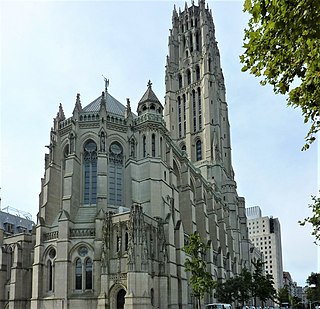
Riverside Church is an interdenominational church in the Morningside Heights neighborhood of Manhattan in New York City, associated with the American Baptist Churches USA and the United Church of Christ. The church was conceived by philanthropist businessman and Baptist John D. Rockefeller Jr. in conjunction with Baptist minister Harry Emerson Fosdick as a large, interdenominational church in Morningside Heights, which is surrounded by academic institutions.

The Manhattan School of Music (MSM) is a private music conservatory in New York City. The school offers bachelor's, master's, and doctoral degrees in the areas of classical and jazz performance and composition, as well as a bachelor's in musical theatre.
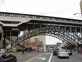
125th Street, co-named Martin Luther King Jr., Boulevard is a two-way street that runs east–west in the New York City borough of Manhattan, from First Avenue on the east to Marginal Street, a service road for the Henry Hudson Parkway along the Hudson River in the west. It is often considered to be the "Main Street" of Harlem.

Manhattan Valley is a neighborhood in the northern part of the Upper West Side of Manhattan in New York City. It is bounded by West 110th Street to the north, Central Park West to the east, West 96th Street to the south, and Broadway to the west.

Manhattanville is a neighborhood in the New York City borough of Manhattan bordered on the north by 135th Street; on the south by 122nd and 125th Streets; on the west by Hudson River; and on the east by Adam Clayton Powell Jr. Boulevard and the campus of City College.
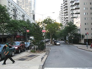
66th Street is a crosstown street in the New York City borough of Manhattan with portions on the Upper East Side and Upper West Side connected across Central Park via the 66th Street transverse. West 66th Street is notable for hosting the Lincoln Center for the Performing Arts between Broadway and Columbus Avenue.
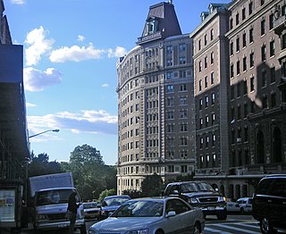
116th Street runs from Riverside Drive, overlooking the Hudson River, to the East River, through the New York City borough of Manhattan. It traverses the neighborhoods of Morningside Heights, Harlem, and Spanish Harlem; the street is interrupted between Morningside Heights and Harlem by Morningside Park.

Morningside Drive is a roughly north–south bi-directional street in the Morningside Heights neighborhood of the New York City borough of Manhattan. It runs from 110th Street in the south, where it forms the continuation of Columbus Avenue, to 122nd Street-Seminary Row in the north, which Morningside Drive becomes after turning to the west and crossing over Amsterdam Avenue.

The Colosseum is an apartment building located at 116th Street and Riverside Drive in Morningside Heights, Manhattan, New York City.
The Hendrik Hudson, formally known as the Hendrik Hudson Residence Hotel, is a Tuscan-style apartment building located on Riverside Drive in Morningside Heights, Manhattan, New York City. The first plans for a building named for Hendrik Hudson on Riverside Drive were announced in October 1897 by Eugene Kirby, a former manager of the Marie Antoinette Hotel. This was to be an 18-story hotel. These plans were never completed, however, and by 1907, an apartment building bearing the name had been constructed instead.

The Interchurch Center is a 19-story limestone-clad office building located at 475 Riverside Drive and West 120th Street in Morningside Heights, Manhattan, New York City. It is the headquarters for the international humanitarian ministry Church World Service, and also houses a wide variety of church agencies and ecumenical and interfaith organizations as well as some nonprofit foundations and faith-related organizations, including the Religion Communicators Council. The National Council of Churches also occupied the building from its inception, but in February 2013, the NCC consolidated its offices on Capitol Hill in Washington, DC, and vacated its New York headquarters facilities. NCC's sister agency, Church World Service, remains a tenant in the building.

89th Street is a one-way street running westbound from the East River to Riverside Drive, overlooking the Hudson River, in the New York City borough of Manhattan. The street is interrupted by Central Park. It runs through the Upper West Side, Carnegie Hill and Yorkville neighborhoods.

133rd Street is a street in Manhattan and the Bronx, New York City. In Harlem, Manhattan, it begins at Riverside Drive on its western side and crosses Broadway, Amsterdam Avenue, and ends at Convent Avenue, before resuming on the eastern side, crossing Seventh Avenue, and ending at Lenox Avenue. In Port Morris in the Bronx, it runs from Bruckner Boulevard/St. Ann's Place to Locust Avenue. The block between Seventh Avenue and Lenox Avenues was once a thriving night spot, known as "Swing Street", with numerous cabarets, jazz clubs, and speakeasies. The street is described in modern times as "a quiet stretch of brownstones and tenement-style apartment houses, the kind of block that typifies this section of central Harlem".
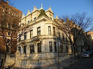
The Schinasi House is a 12,000-square-foot (1,100 m2), 35-room marble mansion located at 351 Riverside Drive on the Upper West Side of Manhattan in New York City. It was built in 1907 for Sephardic Jewish tobacco baron Morris Schinasi. Completed in 1909 at the northeast corner of West 107th Street and Riverside Drive, the three-story, 12,000 square foot mansion was designed in neo-French-Renaissance style by William Tuthill.