
Collect Pond, or Fresh Water Pond, was a body of fresh water in what is now Chinatown in Lower Manhattan, New York City. For the first two centuries of European settlement in Manhattan, it was the main New York City water supply system for the growing city. The location of the former pond later became the site of a jail, and is now memorialized by Collect Pond Park, which includes a reflecting pool to acknowledge the historic importance of this body of water.

Spuyten Duyvil Creek is a short tidal estuary in New York City connecting the Hudson River to the Harlem River Ship Canal and then on to the Harlem River. The confluence of the three water bodies separate the island of Manhattan from the Bronx and the rest of the mainland. Once a distinct, turbulent waterway between the Hudson and Harlem rivers, the creek has been subsumed by the modern ship canal.
Matthijs Hendrikszoon Quast, anglicized as Matthys and Matthew Quast, was a Dutch merchant and explorer in the service of the Dutch East India Company (VOC). Quast made several voyages on the VOC's behalf to Tokugawa Japan, the Qing Empire (China), and Ayutthaya Kingdom ("Siam") but is primarily remembered for his failed 1639 expedition in search of the phantom islands of Rica de Oro and Rica de Plata previously reported by Spanish mariners. He is sometimes credited with the first recorded discovery of the Bonin Islands during the voyage, although the VOC did nothing with the information and they remained unimportant and sparsely settled until the 19th century.

Forsyth Street runs from Houston Street south to Henry Street in the New York City borough of Manhattan. The street was named in 1817 for Lt. Colonel Benjamin Forsyth.

Gowanus is a neighborhood in the northwestern portion of the New York City borough of Brooklyn, within the area once known as South Brooklyn. The neighborhood is part of Brooklyn Community District 6. Gowanus is bounded by Wyckoff Street on the north, Fourth Avenue on the east, the Gowanus Expressway to the south, and Bond Street to the west.
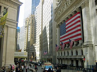
Broad Street is a north–south street in the Financial District of Lower Manhattan in New York City. Originally the Broad Canal in New Amsterdam, it stretches from today's South Street to Wall Street.

The Blackwells Mills Canal House is located at Blackwells Mills Road and Canal Road in Franklin Township, Somerset County, New Jersey, United States, on the Delaware and Raritan Canal. Across the canal is Blackwells Mills, New Jersey.

Nassau Street is in the Financial District, within the borough of Manhattan in New York City. Its southern end is at the intersection with Broad Street and Wall Street, and its northern end is at Spruce Street, at Pace University near the foot of the Brooklyn Bridge. For its entire route, Nassau Street runs one block east of Broadway and Park Row.
The Raritan River Greenway is a proposed path in Somerset County, New Jersey that would link Branchburg Township to the East Coast Greenway with the Delaware and Raritan Canal trail in South Bound Brook. Raritan River Greenway is a priority park for Somerset County.

Centre Street is a north–south street in the New York City borough of Manhattan, running through the Civic Center, Chinatown, and Little Italy neighborhoods of Lower Manhattan. It connects Park Row to the south with Spring Street to the north, where it merges with Lafayette Street. Centre Street carries northbound traffic north of Reade Street and two-way traffic between Reade Street and the Brooklyn Bridge.
William Street is a street in the Financial District of Lower Manhattan, New York City. It runs generally southwest to northeast, crossing Wall Street and terminating at Broad Street and Spruce Street, respectively. Between Beaver Street and Broad Street, the street is known as South William Street. Between Beekman Street and Spruce Street, in front of New York Downtown Hospital, William Street is a pedestrian-only street.

Tappen Park is a small park and square in the Stapleton neighborhood on the East Shore of Staten Island, New York City. It is bounded by Bay Street on the east, Water Street on the north, and Canal Street on the south and west. It is named for First World War veteran James Tappen. The land that the park is sited on was first purchased by the government in 1867, and it was acquired by the City of New York in 1898.
Church Street and Trinity Place form a single northbound roadway in Lower Manhattan, New York City. Its northern end is at Canal Street and its southern end is at Morris Street, where Trinity Place merges with Greenwich Street. The dividing point is Liberty Street.

Coenties Slip is a street in the Financial District of Manhattan in New York City. It runs southeast for two blocks in Lower Manhattan from Pearl Street to South Street. A walkway runs an additional block north from Pearl Street to Stone Street.
Gracht is a Dutch word for a canal within a city. Grachten often have a round shape, and form a circle around the city cores in the Netherlands, Belgium, and northern Germany. Outside the Netherlands, the word grachten mostly refers to the city canals of Amsterdam and also Utrecht, Leiden and The Hague. The Koninginnegracht in The Hague was conceived by King Willem I for the promotion of tourism in the early 19th century. Since 2009 the Willemsvaart once more offers tours over this gracht, to Scheveningen, known as "StrandRelax" or "BeachRelax", a unique stretch of sand between The Hague and the sea.

One Hudson Square is an 18-story industrial building located in the Hudson Square neighborhood of Manhattan, New York City. It was built in 1929 and 1930 and was designed by noted architect Ely Jacques Kahn in the modern-classical style.

Albert Capsouto Park is a triangular-shaped pocket park in the Tribeca neighborhood of Lower Manhattan in New York City. It is bounded by Canal Street to the northeast, Varick Street to the west, and Laight Street to the south. It is located just east of the Holland Tunnel exit plaza, formerly known as St. John's Park.
Marketfield Street is a short one-way, one-block-long alleyway in the Financial District of Manhattan, New York City. The street begins as a southern branch of Beaver Street, then veers east and north, ending at Broad Street. Alternative past names include Exchange Street, Field Street, Fieldmarket Street, Oblique Road, and Petticoat Lane.

The Oudeschans, or Oude Schans, originally the Nieuwe Gracht, is a wide canal in the eastern part of the inner city of Amsterdam.
Exchange Place is a street in the Financial District of Lower Manhattan, New York City. The street runs five blocks between Trinity Place in the west and Hanover Street in the east.
