Broadway is a street and major thoroughfare in the U.S. state of New York. The street runs from State Street at Bowling Green in the south of Manhattan for 13 mi (20.9 km) through the borough, over the Broadway Bridge, and 2 mi (3.2 km) through the Bronx, exiting north from New York City to run an additional 18 mi (29.0 km) through the Westchester County municipalities of Yonkers, Hastings-On-Hudson, Dobbs Ferry, Irvington, Tarrytown, and Sleepy Hollow, after which the road continues, but is no longer called "Broadway". The latter portion of Broadway north of the George Washington Bridge/I-95 underpass comprises a portion of U.S. Route 9.

The Upper West Side (UWS) is a neighborhood in the borough of Manhattan in New York City. It is bounded by Central Park on the east, the Hudson River on the west, West 59th Street to the south, and West 110th Street to the north. The Upper West Side is adjacent to the neighborhoods of Hell's Kitchen to the south, Columbus Circle to the southeast, and Morningside Heights to the north.

Manhattan Valley is a neighborhood in the northern part of the Upper West Side of Manhattan in New York City. It is bounded by West 110th Street to the north, Central Park West to the east, West 96th Street to the south, and Broadway to the west.
Seventh Avenue—co-named Fashion Avenue in the Garment District and known as Adam Clayton Powell Jr. Boulevard north of Central Park—is a thoroughfare on the West Side of the borough of Manhattan in New York City. It is southbound below the park and a two-way street north of it.
Eighth Avenue is a major north–south avenue on the west side of Manhattan in New York City, carrying northbound traffic below 59th Street. It is one of the original avenues of the Commissioners' Plan of 1811 to run the length of Manhattan, though today the name changes twice: At 59th Street/Columbus Circle, it becomes Central Park West, where it forms the western boundary of Central Park, and north of 110th Street/Frederick Douglass Circle, it is known as Frederick Douglass Boulevard before merging onto Harlem River Drive north of 155th Street.

Tenth Avenue, known as Amsterdam Avenue between 59th Street and 193rd Street, is a north-south thoroughfare on the West Side of Manhattan in New York City. It carries uptown (northbound) traffic as far as West 110th Street, after which it continues as a two-way street.
Eleventh Avenue is a north–south thoroughfare on the far West Side of the borough of Manhattan in New York City, located near the Hudson River. Eleventh Avenue originates in the Meatpacking District in the Greenwich Village and West Village neighborhoods at Gansevoort Street, where Eleventh Avenue, Tenth Avenue, and West Street intersect. It is considered part of the West Side Highway between 22nd and Gansevoort Streets.

Interstate 95 (I-95) is part of the Interstate Highway System and runs from Miami, Florida, to the Canada–United States border near Houlton, Maine. In the US state of New York, I-95 extends 23.50 miles (37.82 km) from the George Washington Bridge in New York City to the Connecticut state line at Port Chester. The George Washington Bridge carries I-95 across the Hudson River from New Jersey into New York City. There, I-95 runs across Upper Manhattan on the Trans-Manhattan Expressway for 0.81 miles (1.30 km) through Washington Heights. It continues east across the Harlem River on the Alexander Hamilton Bridge and onto the Cross Bronx Expressway. In the Bronx, I-95 leaves the Cross Bronx at the Bruckner Interchange, joining the Bruckner Expressway to its end. North of the interchange with Pelham Parkway, it then continues northeast via the New England Thruway out of New York City into Westchester County and to the Connecticut state line, where I-95 continues on the Connecticut Turnpike.
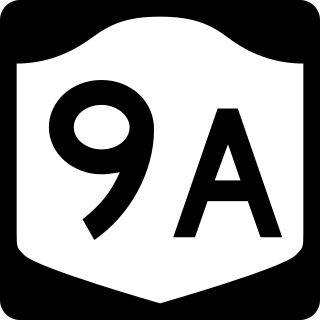
New York State Route 9A (NY 9A) is a state highway in the vicinity of New York City in the United States. Its southern terminus is at Battery Place near the northern end of the Brooklyn–Battery Tunnel in New York City, where it intersects with both the unsigned Interstate 478 (I-478) and FDR Drive. The northern terminus of NY 9A is at U.S. Route 9 (US 9) in Peekskill. It is predominantly an alternate route of US 9 between New York City and Peekskill; however, in New York City, it is a major route of its own as it runs along the West Side Highway and Henry Hudson Parkway. It is also one of only two signed New York State routes in Manhattan. In northern Westchester County, NY 9A follows the Briarcliff–Peekskill Parkway.

86th Street is a major two-way street in the Upper East Side and Upper West Side of the New York City borough of Manhattan. It runs in two major sections: between East End and Fifth Avenue on the Upper East Side, and between Central Park West and Riverside Drive on the Upper West Side. The western segment feeds into the 86th Street transverse across Central Park, which connects to East 84th and 85th Streets on the eastern side.
59th Street is a crosstown street in the New York City borough of Manhattan, running from York Avenue and Sutton Place on the East Side of Manhattan to the West Side Highway on the West Side. The three-block portion between Columbus Circle and Grand Army Plaza is known as Central Park South, since it forms the southern border of Central Park. There is a gap in the street between Ninth Avenue/Columbus Avenue and Columbus Circle, where the Deutsche Bank Center is located. While Central Park South is a bidirectional street, most of 59th Street carries one-way traffic.
66th Street is a crosstown street in the New York City borough of Manhattan with portions on the Upper East Side and Upper West Side connected across Central Park via the 66th Street transverse. West 66th Street is notable for hosting the Lincoln Center for the Performing Arts between Broadway and Columbus Avenue.
79th Street is a major two-way street on the Upper East Side and Upper West Side of the New York City borough of Manhattan. It runs in two major sections: between East End and Fifth Avenues on the Upper East Side, and between Columbus Avenue and Henry Hudson Parkway on the Upper West Side. The two segments are connected by the 79th Street transverse across Central Park, as well as one block of 81st Street.

96th Street is a major two-way street on the Upper East Side and Upper West Side sections of the New York City borough of Manhattan. It runs in two major sections: between FDR Drive and Fifth Avenue on the Upper East Side, and between Central Park West and the Henry Hudson Parkway on the Upper West Side. The two segments are connected by the 97th Street transverse across Central Park, which links the disconnected segments of 96th and 97th Streets on each side.

The Central Park West Historic District is located along Central Park West, between 61st and 97th Streets, on the Upper West Side of Manhattan in New York City, United States. The district was added to the National Register of Historic Places on November 9, 1982. The district encompasses a portion of the Upper West Side-Central Park West Historic District as designated by the New York City Landmarks Preservation Commission, and contains a number of prominent New York City designated landmarks, including the Dakota, a National Historic Landmark. The buildings date from the late 19th century to the early 1940s and exhibit a variety of architectural styles. The majority of the district's buildings are of neo-Italian Renaissance style, but Art Deco is a popular theme as well.
St. John's Park was a 19th-century park and square, and the neighborhood of townhouses around it, in what is now the Tribeca neighborhood of Lower Manhattan, New York City. The square was bounded by Varick Street, Laight Street, Hudson Street and Beach Street, now also known for that block as Ericsson Place. Although the name "St. John's Park" is still in use, it is no longer a park and is inaccessible to the public.

93rd Street is a one-way street in the New York City borough of Manhattan. Like most of Uptown Manhattan east–west streets crossing Central Park, it is split in two segments. Its west segment traverses the Upper West Side and runs from Riverside Drive to Central Park West, while its east segment traverses the Upper East Side and runs from 5th Avenue to East End Avenue.

89th Street is a one-way street running westbound from the East River to Riverside Drive, overlooking the Hudson River, in the New York City borough of Manhattan. The street is interrupted by Central Park. It runs through the Upper West Side, Carnegie Hill and Yorkville neighborhoods.
74th Street is an east–west street carrying pedestrian traffic and eastbound automotive/bicycle traffic in the New York City borough of Manhattan. It runs through the Upper East Side neighborhood, and the Upper West Side neighborhood, on both sides of Central Park.