4th Street (Manhattan)

Last updated
Template:Attached KML/4th Street (Manhattan)
KML is from Wikidata
4th Street
Washington Square South
W4th Jane 9th Av jeh.jpg
West 4th Street at Jane Street
4th Street (Manhattan)
Former name(s)Asylum Street
Maintained by NYCDOT
Length2.0 mi (3.2 km) [1]
Location Manhattan, New York City
Postal code10014, 10012, 10003, 10009
West end West 13th  / Gansevoort Streets in Meatpacking
East end Avenue D in East Village
North Waverly Place (Bank to Grove Streets)
Washington Place (Grove Street to Broadway)
5th Street (Bowery to Avenue D)
South Hudson Street (13th Street to 8th Avenue)
Bleecker Street (8th to 6th Avenues)
3rd Street (6th Avenue to Avenue D)

4th Street is a street in Lower Manhattan, New York City. It starts at Avenue D as East 4th Street and continues to Broadway, where it becomes West 4th Street. It continues west until the Avenue of the Americas (Sixth Avenue), where West 4th Street turns north and confusingly intersects with West 10th, 11th, 12th, and 13th Streets in Greenwich Village. Most of the street has the same 40-foot (12 m) width between curbstones as others in the prevailing street grid, striped as two curbside lanes and one traffic lane, with one-way traffic eastbound. The portion from Seventh to Eighth Avenues is westbound (northbound geographically) and is approximately 35 feet (11 m) wide, a legacy of the original Greenwich Village street grid. The section of four short blocks from MacDougal Street to University Place which forms the southern border of Washington Square Park is called Washington Square South. [2]

Contents

The north/south portion (from Sixth Avenue to 13th Street) was formerly called Asylum Street, after the Orphan Asylum Society, which stood on Asylum Street between Bank Street and Troy Street (now West 12th Street). The asylum was demolished in 1833 and the street was renamed West 4th Street. Later, the cross streets (Amos, Hammond, and Troy) were renamed West 10th, 11th, and 12th Streets, causing the current confusion. [3]

Landmarks

Due to the layout of streets in Greenwich Village, West 4th Street, running south to north, intersects West 12th Street, which runs west to east West 4th and West 12th Intersection.JPG
Due to the layout of streets in Greenwich Village, West 4th Street, running south to north, intersects West 12th Street, which runs west to east

Located near Washington Square Park's south-west corner, between MacDougal Street and Sixth Avenue, The Washington Square Methodist Church (135 West Fourth) is an early Romanesque Revival marble edifice designed by Gamaliel King and built in 1859–60. [4] Dubbed the "Peace Church" for its support of Vietnam War protesters, Washington Square Church long provided a neighborhood base for activist groups such as the Black Panthers and Gay Men's Health Crisis. The church was sold in 2005 to a developer for conversion into residential units. [5] During construction, parts of the church were salvaged to form the furniture and interior architecture of Urban Spring, a cafe in Fort Greene, Brooklyn.

Judson Memorial Church, located at the corner of Thompson Street and Washington Square South, was designed by architect Stanford White and stained glass master John La Farge.

The West Fourth Street subway station ( A , B , C , D , E , F , <F> , and M trains) at Sixth Avenue is one of the major transfer points in the New York City Subway.

The street is home to the basketball and handball West Fourth Street Courts, known as "The Cage", a hangout for some of New York's best basketball players and the site of a citywide streetball tournament. [6]

Historic locations and residents

West 4th Street has always been a center of the Village's bohemian lifestyle. The Village's first tearoom, The Mad Hatter, was located at 150 West 4th Street and served as a meeting place for intellectuals and artists.

The infamous Golden Swan bar (known as the "Hell Hole"), at the corner of Sixth Avenue, was a famous haunt of Eugene O'Neill and the setting and inspiration for his play The Iceman Cometh . Writer Willa Cather's first New York residence was at 60 Washington Square South (4th Street between LaGuardia Place and Thompson Place) and radical journalists John Reed and Lincoln Steffens lived nearby at 42 Washington Square South. Reed later worked in a room in the Studio Club building to complete the series of articles that became his account of the Bolshevik Revolution, Ten Days That Shook the World , later the source for the film Reds . [7]

Sculptor and art patron Gertrude Vanderbilt Whitney established the Whitney Studio Club in a brownstone at 147 West 4th Street in 1918 as a place for young artists to gather and show their work. The facility operated for ten years and was the second incarnation of what would later become the Whitney Museum of American Art. [8] It started the careers of such artists as Ashcan School painter John Sloan, Edward Hopper, whose first one-man exhibit was held there in 1920, and social realists Reginald Marsh and Isabel Bishop. Sloan lived at 240 West 4th St and painted locations on the street including the Golden Swan.

The street was later home to the famous folk club Gerde's Folk City (11 West 4th Street), which hosted the New York debuts of Bob Dylan in 1961 and Simon & Garfunkel. Dylan also lived from early-1962 until late-1964 in a small $60-per-month studio apartment at 161 West 4th Street; [9] the cover of The Freewheelin' Bob Dylan was photographed at nearby Jones Street at West 4th, and the street may have inspired his 1965 hit song "Positively 4th Street". Louis Abolafia, the 1968 hippie candidate for the presidency, had his artists' studio and campaign headquarters at 129 East 4th St.

Music venue The Bottom Line was at 15th West 4th Street from 1974 to 2004.

Related Research Articles

<span class="mw-page-title-main">Greenwich Village</span> Neighborhood of Manhattan in New York City

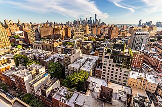
Greenwich Village, or simply the Village, is a neighborhood on the west side of Lower Manhattan in New York City, bounded by 14th Street to the north, Broadway to the east, Houston Street to the south, and the Hudson River to the west. Greenwich Village also contains several subsections, including the West Village west of Seventh Avenue and the Meatpacking District in the northwest corner of Greenwich Village.
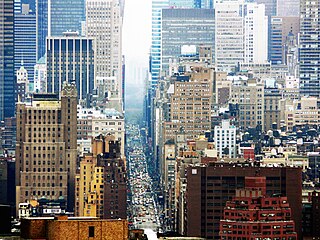
<span class="mw-page-title-main">Christopher Street</span> Street in Manhattan, New York

Christopher Street is a street in the West Village neighborhood of the New York City borough of Manhattan. It is the continuation of 9th Street west of Sixth Avenue.

<span class="mw-page-title-main">Sixth Avenue</span> North/south avenue in Manhattan, New York City, also known as Avenue of the Americas

Sixth Avenue – also known as Avenue of the Americas, although this name is seldom used by New Yorkers – is a major thoroughfare in New York City's borough of Manhattan, on which traffic runs northbound, or "uptown". It is commercial for much of its length.

<span class="mw-page-title-main">8th Street and St. Mark's Place</span> West-east street in Manhattan, New York

8th Street is a street in the New York City borough of Manhattan that runs from Sixth Avenue to Third Avenue, and also from Avenue B to Avenue D; its addresses switch from West to East as it crosses Fifth Avenue. Between Third Avenue and Avenue A, it is named St. Mark's Place, after the nearby St. Mark's Church in-the-Bowery on 10th Street at Second Avenue.

<span class="mw-page-title-main">Seventh Avenue (Manhattan)</span> North-south avenue in Manhattan, New York

Seventh Avenue—co-named Fashion Avenue in the Garment District and known as Adam Clayton Powell Jr. Boulevard north of Central Park—is a thoroughfare on the West Side of the borough of Manhattan in New York City. It is southbound below the park and a two-way street north of it.

<span class="mw-page-title-main">The Gaslight Cafe</span> Coffeehouse

The Gaslight Cafe was a coffeehouse in the Greenwich Village neighborhood of Manhattan, New York. Also known as The Village Gaslight, it opened in 1958 and became notable as a venue for folk music and other musical acts. It closed in 1971.

<span class="mw-page-title-main">West Village</span> Neighborhood of Manhattan in New York City

The West Village is a neighborhood in the western section of the larger Greenwich Village neighborhood of Lower Manhattan, New York City. The West Village is bounded by the Hudson River to the west and 14th Street to the north. The eastern boundary is variously cited as Greenwich Avenue, Seventh Avenue, or Sixth Avenue, while the southern boundary is either Houston Street or Christopher Street.

<span class="mw-page-title-main">West Fourth Street–Washington Square station</span> New York City Subway station in Manhattan

The West Fourth Street–Washington Square station is an express station and transfer stop on the IND Sixth Avenue and IND Eighth Avenue Lines of the New York City Subway, located at the intersection of West Fourth Street and Sixth Avenue in Greenwich Village, Manhattan. It is served by the A, D, E, and F trains at all times; the B and M trains on weekdays; the C train at all times except late nights; and the <F> train during rush hours in the peak direction.

<span class="mw-page-title-main">West Broadway</span> Street in Manhattan, New York

West Broadway is a north-south street in the New York City borough of Manhattan, separated into two parts by Tribeca Park. The northern part begins at Tribeca Park, near the intersection of Avenue of the Americas, Walker Street and Beach Street in Tribeca. It runs northbound as a one-way street past Canal Street and becomes two-way at the intersection with Grand Street one block farther north. West Broadway then operates as a main north-south thoroughfare through SoHo until its northern end at Houston Street, on the border between SoHo and Greenwich Village. North of Houston Street, it is designated as LaGuardia Place, which continues until Washington Square South.

<span class="mw-page-title-main">Waverly Place</span> Street in Manhattan, New York

Waverly Place is a narrow street in the Greenwich Village section of the New York City borough of Manhattan, that runs from Bank Street to Broadway. Waverly changes direction roughly at its midpoint at Christopher Street, turning about 120 degrees from a north/south street to a northwest/southeast street. At Christopher Street, the traffic direction changes as well, from southbound to westbound. At the intersection where this transition occurs, Waverly branches into a Y, creating an intersection of Waverly Place with itself.

<span class="mw-page-title-main">Whitney Museum of American Art (original building)</span> United States historic place

The Whitney Museum of American Art original building is a collection of three 1838 rowhouses located at 8–12 West 8th Street between Fifth Avenue and MacDougal Street in the Greenwich Village neighborhood of Manhattan, New York City. In 1907, Gertrude Vanderbilt Whitney established the Whitney Studio Gallery at 8 West 8th Street adjacent to her own MacDougal Alley studio. This, and the later Whitney Studio Club at 147 West 4th Street, were intended to provide young artists with places to meet and exhibit their works.

<span class="mw-page-title-main">MacDougal Street</span> Street in Manhattan, New York

MacDougal Street is a one-way street in the Greenwich Village and SoHo neighborhoods of Manhattan, New York City. The street is bounded on the south by Prince Street and on the north by West 8th Street; its numbering begins in the south. Between Waverly Place and West 3rd Street it carries the name Washington Square West and the numbering scheme changes, running north to south, beginning with #29 Washington Square West at Waverly Place and ending at #37 at West 3rd Street. Traffic on the street runs southbound (downtown).

<span class="mw-page-title-main">Greenwich Avenue</span> Avenue in Manhattan, New York

Greenwich Avenue, formerly Greenwich Lane, is a southeast-northwest avenue located in the Greenwich Village neighborhood of Manhattan, New York City. It extends from the intersection of 6th Avenue and 8th Street at its southeast end to its northwestern end at 8th Avenue between 14th Street and 13th Street. It is sometimes confused with Greenwich Street. Construction of West Village Park, bounded by Greenwich Avenue, 7th Avenue, and 12th Street, began in 2016.

<span class="mw-page-title-main">South Village</span> Neighborhood of Manhattan in New York City

The South Village is a largely residential area that is part of the larger Greenwich Village in Lower Manhattan, New York City, directly below Washington Square Park. Known for its immigrant heritage and bohemian history, the architecture of the South Village is primarily tenement-style apartment buildings, indicative of the area's history as an enclave for Italian-American immigrants and working-class residents of New York.

<span class="mw-page-title-main">Charlton–King–Vandam Historic District</span> Historic district in New York, United States

The Charlton–King–Vandam Historic District is a small historic district in Lower Manhattan, New York City. Designated by the New York City Landmarks Preservation Commission (NYCLPC) in 1966, the district contains "the city's largest concentration of row houses in the Federal style, as well as a significant concentration of Greek Revival houses." It is sometimes included as part of the South Village or Hudson Square, though it is historically distinct from both neighborhoods.

<span class="mw-page-title-main">Minetta Creek</span> Buried stream in Manhattan, New York

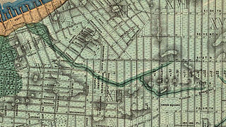
Minetta Creek was one of the largest natural watercourses in Manhattan, New York City, United States. Minetta Creek was fed from two tributaries, one originating at Fifth Avenue and 21st Street, and the other originating at Sixth Avenue and 16th Street. They joined near Fifth Avenue and 11th Street then took a southwesterly course. Minetta Creek's name is thought to have originated from either the Native American term "Manette", meaning "Devil's Water", or the Dutch word "Minnetje", meaning "the little one".

Thompson Street is a street in the Lower Manhattan neighborhoods of Greenwich Village and SoHo in New York City, which runs north–south, from Washington Square Park at Washington Square South to the Avenue of the Americas below Grand Street, where the street turns right to Sixth Avenue; it thus does not connect with Canal Street just a half block south of the turning point. It runs parallel to and between Sullivan Street, and LaGuardia Place which becomes West Broadway. Vehicular traffic goes southbound.

<span class="mw-page-title-main">Sullivan Street</span> Street in Manhattan, New York

Sullivan Street is a street in Lower Manhattan, which previously ran north from Duarte Square at Canal Street, but since around 2012 begins at Broome Street, to Washington Square South, through the neighborhoods of Hudson Square, SoHo, the South Village and Greenwich Village. It runs parallel to and between Macdougal Street and Thompson Street. Part of the street is in the MacDougal–Sullivan Gardens Historic District. The street was named for Revolutionary War Major General John Sullivan in 1799; before then, it was known as Locust Street.

<span class="mw-page-title-main">Charles Street (Manhattan)</span> Street in Manhattan, New York

Charles Street is a street in the West Village neighborhood of Manhattan in New York City. It runs east to west from Greenwich Avenue to West Street. The street was named after Charles Christopher Amos, who owned the parcel the street passed through. Amos is also the namesake of Christopher Street, two blocks to the south, and the former Amos Street, which is now West 10th Street. Charles Lane is a one-block alley located between Charles and Perry Streets and Washington and West Streets. From 1866 to 1936, the section of Charles Street between Bleecker Street and West 4th Street was called Van Ness Place after a farm, owned by the Van Ness family, which had occupied the square bounded by Bleecker, West 4th, Charles and Perry Streets until 1865.

References

  1. Google (August 31, 2015). "4th Street (Manhattan)" (Map). Google Maps . Google. Retrieved August 31, 2015.
  2. "Washington Square South" Google Maps
  3. Walsh, Kevin (November 1999). "The Street Necrology of Greenwich Village". Forgotten NY . Retrieved August 17, 2015.
  4. New York City Landmarks Preservation Commission (2003). Guide to New York City Landmarks. John Wiley and Sons. p. 50.
  5. Amateau, Albert (July 27, 2005). "Washington Square church is sold". The Villager. Vol. 75, no. 10. Archived from the original on 2005-11-09.
  6. Martindale, Wight Jr. (2005). Inside the Cage: A Season at West Fourth Street's Legendary Tournament. Simon Spotlight Entertainment.
  7. Bunyan, Patrick (1999). All Around the Town: Amazing Manhattan Facts and Curiosities. Fordham University Press. pp. 143, 147.
  8. Wolff, Janet (2003). "Women at the Whitney, 1910–1930". In Carbonell, Bettina Messias (ed.). Museum Studies: An Anthology of Contexts. Blackwell Publishing. p. 485.
  9. Sounes, Howard (2002). Down the Highway: The Life of Bob Dylan. Grove Press. pp. 108, 164.