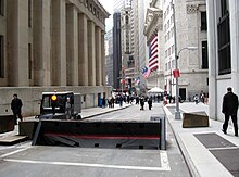
The Financial District of Lower Manhattan, also known as FiDi, is a neighborhood located on the southern tip of Manhattan in New York City. It is bounded by the West Side Highway on the west, Chambers Street and City Hall Park on the north, Brooklyn Bridge on the northeast, the East River to the southeast, and South Ferry and the Battery on the south.

South Ferry is at the southern tip of Manhattan in New York City and is the embarkation point for ferries to Staten Island and Governors Island. Battery Park, abutting South Ferry on the west, has docking areas for ferries to Liberty Island and Ellis Island. Its name is derived from the more southerly route of service of the historical South Ferry Company in comparison to the Fulton Ferry.

Atlantic Avenue is a major thoroughfare in the New York City boroughs of Brooklyn and Queens. It stretches from the Brooklyn waterfront on the East River all the way to Jamaica, Queens. Atlantic Avenue runs parallel to Fulton Street for much of its course through Brooklyn, where it serves as a border between the neighborhoods of Prospect Heights and Fort Greene and between Bedford-Stuyvesant and Crown Heights, and between Brooklyn Heights and Cobble Hill. This stretch of avenue is known for having a high rate of pedestrian fatalities and has been described as "the killing fields of the city."
The BMT Nassau Street Line is a rapid transit line of the B Division of the New York City Subway system in Manhattan. At its northern end, the line is a westward continuation of the BMT Jamaica Line in Brooklyn after the Jamaica Line crosses the Williamsburg Bridge into Manhattan. The Nassau Street Line continues south to a junction with the BMT Broadway Line just before the Montague Street Tunnel, after which the line reenters Brooklyn. Although the tracks merge into the Broadway Line south of Broad Street, there has been no regular service south of the Broad Street station since June 25, 2010. While the line is officially recognized as the Nassau Street Line, it only serves one station on Nassau Street: Fulton Street.

The Park Row station was a major elevated railway terminal constructed on the Manhattan side of the Brooklyn Bridge, across from New York City Hall and the IRT’s elevated City Hall station. It served as the terminal for BMT services operating over the Brooklyn Bridge Elevated Line from the BMT Fulton Street Line, BMT Myrtle Avenue Line, and their feeders. Until the opening of the nearby Williamsburg Bridge to elevated train traffic in 1913, it was the only Manhattan station available for elevated trains from Brooklyn and the only elevated station in Manhattan to be owned by a company other than the IRT or its predecessors.
The IND Fulton Street Line is a rapid transit line of the IND Division of the New York City Subway, running from the Cranberry Street Tunnel under the East River through all of central Brooklyn to a terminus in Ozone Park, Queens. The IND Rockaway Line branches from it just east of Rockaway Boulevard. The A train runs express during daytime hours and local at night on the underground portion of the line; it runs local on the elevated portion of the line at all times. The C train runs local on the underground portion of the line at all times except late nights.

The Broad Street station is a station on the BMT Nassau Street Line of the New York City Subway at the intersection of Broad and Wall Streets in the Financial District of Manhattan. It serves as the southern terminal for J trains at all times and for Z trains during rush hours in the peak direction.

Fulton Center is a subway and retail complex centered at the intersection of Fulton Street and Broadway in Lower Manhattan, New York City. The complex was built as part of a $1.4 billion project by the Metropolitan Transportation Authority (MTA), a public agency of the state of New York, to rehabilitate the New York City Subway's Fulton Street station. The work involved constructing new underground passageways and access points into the complex, renovating the constituent stations, and erecting a large station building that doubles as a part of the Westfield World Trade Center mall.

47th Street is an east–west running street between First Avenue and the West Side Highway in the borough of Manhattan in New York City. Traffic runs one way along the street, from east to west, starting at the headquarters of the United Nations. The street features the Diamond District in a single block, where the street is also known as Diamond Jewelry Way, and also courses through Times Square.

Chambers Street is a two-way street in the New York City borough of Manhattan. It runs from River Terrace, Battery Park City in the west, past PS 234, The Borough of Manhattan Community College, and Stuyvesant High School, to the Manhattan Municipal Building at 1 Centre Street in the east. Between Broadway and Centre Street, Chambers Street forms the northern boundary of the grounds surrounding New York City Hall and the Tweed Courthouse. Opposite the Tweed Courthouse sits the Surrogate's Courthouse for Manhattan. 280 Broadway the Marble Palace, lies west of there, on the north side of Chambers.

The Fulton Street station is a major New York City Subway station complex in Lower Manhattan. It consists of four linked stations on the IND Eighth Avenue Line, the IRT Lexington Avenue Line, the BMT Nassau Street Line and the IRT Broadway–Seventh Avenue Line. The complex is served by the 2, 4, A, and J trains at all times. The 3, 5, and C trains stop here at all times except late nights, and the Z stops during rush hours in the peak direction.

41 Park Row, also 147 Nassau Street and formerly the New York Times Building, is an office building in the Financial District of Manhattan in New York City, across from City Hall and the Civic Center. It occupies a plot abutting Nassau Street to the east, Spruce Street to the north, and Park Row to the west. The building, originally the headquarters of The New York Times, is the oldest surviving structure of Lower Manhattan's former "Newspaper Row" and has been owned by Pace University since 1951.
Herman "Pat" Herst Jr. was a writer of philatelic literature, in many cases on the history of the hobby, as well as a stamp dealer and stamp auctioneer. He began his career on Nassau Street in New York City in 1933, moving to Shrub Oak, New York in 1946, remaining there until he finally retired to Florida in 1973.

The Fulton–Nassau Historic District is a federally designated historic area of New York City roughly bounded by Broadway and Park Row, Nassau, Dutch and William Streets, Ann and Spruce Streets, and Liberty Street, in lower Manhattan. It contains a mix of late 19th- and early 20th-century architectural styles. The historic district lies just south of City Hall Park and east of lower Broadway. It is a historic district listed on the National Register of Historic Places.
Spruce Street is a three-block-long street in the Financial District of Lower Manhattan, New York City. It starts at Park Row, near the foot of the Brooklyn Bridge, and runs east to Gold Street, intersecting with Nassau Street.

150 Nassau Street, also known as the Park Place Tower and the American Tract Society Building, is a 23-story, 291-foot (89 m) building in the Financial District of Lower Manhattan in New York City. It is located at the southeast corner of Spruce Street and Nassau Street, next to 8 Spruce Street, the former New York Times Building, and New York City Hall.