
Harlem is a neighborhood in Upper Manhattan, New York City. It is bounded roughly by the Hudson River on the west; the Harlem River and 155th Street on the north; Fifth Avenue on the east; and Central Park North on the south. The greater Harlem area encompasses several other neighborhoods and extends west and north to 155th Street, east to the East River, and south to Martin Luther King Jr. Boulevard, Central Park, and East 96th Street.

Washington Heights is a neighborhood in the northern part of the borough of Manhattan in New York City. It is named for Fort Washington, a fortification constructed at the highest natural point on Manhattan by Continental Army troops to defend the area from the British forces during the American Revolutionary War. Washington Heights is bordered by Inwood to the north along Dyckman Street, by Harlem to the south along 155th Street, by the Harlem River and Coogan's Bluff to the east, and by the Hudson River to the west.

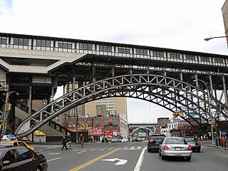
Coogan's Bluff is a promontory near the western shore of the Harlem River in the Washington Heights neighborhood of Upper Manhattan in New York City. Its boundaries extend approximately from 155th Street and the Macombs Dam Bridge viaduct to 160th Street, between Edgecombe Avenue and the river. A deep escarpment descends 175 feet (53 m) from Edgecombe Avenue to the river, creating a sheltered area between the bluff and river known as Coogan's Hollow. From 1890 to 1964, the hollow was home to the Polo Grounds sports stadium.

Riverside Drive is a north–south avenue in the New York City borough of Manhattan. The road runs on the west side of Upper Manhattan, generally paralleling the Hudson River and Riverside Park between 72nd Street and the vicinity of the George Washington Bridge at 181st Street. North of 96th Street, Riverside Drive is a wide divided roadway. At several locations, a serpentine service road diverges from the main road, providing access to the residential buildings. Several viaducts connect the various segments of Riverside Drive, including the 2,047-foot (624 m) Manhattan Valley Viaduct between Tiemann Place and 135th Street. A disconnected section of Riverside Drive exists in Inwood, Manhattan. The New York City Landmarks Preservation Commission has designated the original section of Riverside Drive, between 72nd and 125th streets, as part of a scenic landmark that also includes Riverside Park.
125th Street, co-named Martin Luther King Jr., Boulevard is a two-way street that runs east–west in the New York City borough of Manhattan, from First Avenue on the east to Marginal Street, a service road for the Henry Hudson Parkway along the Hudson River in the west. It is often considered to be the "Main Street" of Harlem.
Seventh Avenue—co-named Fashion Avenue in the Garment District and known as Adam Clayton Powell Jr. Boulevard north of Central Park—is a thoroughfare on the West Side of the borough of Manhattan in New York City. It is southbound below the park and a two-way street north of it.

Tenth Avenue, known as Amsterdam Avenue between 59th Street and 193rd Street, is a north-south thoroughfare on the West Side of Manhattan in New York City. It carries uptown (northbound) traffic as far as West 110th Street, after which it continues as a two-way street.
The Macombs Dam Bridge is a swing bridge across the Harlem River in New York City, connecting the boroughs of Manhattan and the Bronx. The bridge is operated and maintained by the New York City Department of Transportation (NYCDOT).

Harlem River Drive is a 4.20-mile (6.76 km) controlled-access parkway in the New York City borough of Manhattan. It runs along the west bank of the Harlem River from the Triborough Bridge in East Harlem to 10th Avenue in Inwood, where the parkway ends and the road continues northwest as Dyckman Street. South of the Triborough Bridge, the parkway continues toward lower Manhattan as FDR Drive. All of Harlem River Drive is designated New York State Route 907P (NY 907P), an unsigned reference route.
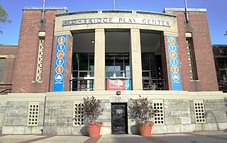
Highbridge Park is a public park on the western bank of the Harlem River in Washington Heights, Manhattan, New York City. It stretches between 155th Street and Dyckman Street in Upper Manhattan. The park is operated by the New York City Department of Parks and Recreation. The City maintains the southern half of the park, while the northern half is maintained by the non-profit New York Restoration Project. Prominent in the park are the Manhattan end of the High Bridge, the High Bridge Water Tower, and the Highbridge Play Center.

The 155th Street station is a local station on the IND Concourse Line of the New York City Subway. It is located at the intersection of the bi-level 155th Street's lower level and Frederick Douglass Boulevard, at the border of Harlem and the Coogan's Bluff section of Washington Heights neighborhoods of Manhattan. It is served by the D train at all times except rush hours in the peak direction and the B weekdays only. The station opened in 1933, along with the rest of the Concourse Line.
116th Street runs from Riverside Drive, overlooking the Hudson River, to the East River, through the New York City borough of Manhattan. It traverses the neighborhoods of Morningside Heights, Harlem, and Spanish Harlem; the street is interrupted between Morningside Heights and Harlem by Morningside Park.

96th Street is a major two-way street on the Upper East Side and Upper West Side sections of the New York City borough of Manhattan. It runs in two major sections: between FDR Drive and Fifth Avenue on the Upper East Side, and between Central Park West and the Henry Hudson Parkway on the Upper West Side. The two segments are connected by the 97th Street transverse across Central Park, which links the disconnected segments of 96th and 97th Streets on each side.

The Manhattan Waterfront Greenway is a waterfront greenway for walking or cycling, 32 miles (51 km) long, around the island of Manhattan, in New York City. The largest portions are operated by the New York City Department of Parks and Recreation. It is separated from motor traffic, and many sections also separate pedestrians from cyclists. There are three principal parts — the East, Harlem and Hudson River Greenways.

The M1, M2, M3, and M4 are four local bus routes that operate the Fifth and Madison Avenues Lines – along the one-way pair of Madison and Fifth Avenues in the Manhattan borough of New York City. Though the routes also run along other major avenues, the majority of their route is along Madison and Fifth Avenues between Greenwich Village and Harlem.

Dyckman Street, occasionally called West 200th Street, is a street in the Inwood neighborhood of Manhattan, New York City. It is commonly considered to be a crosstown street because it runs from the Hudson River to the Harlem River and intersects Broadway. However, in its true geographical orientation, Dyckman Street runs roughly from north-northwest to south-southeast, and the majority of the street that lies southeast of Broadway runs closer to a north-south direction than east-west.

145th Street is a major crosstown street in the Harlem neighborhood, in the New York City borough of Manhattan. It is one of the 15 crosstown streets mapped out in the Commissioner's Plan of 1811 that established the numbered street grid in Manhattan. It forms the southern border of the Sugar Hill neighborhood within Harlem.

Jackie Robinson Park is a public park in the Hamilton Heights and Harlem neighborhoods of Manhattan in New York City. The approximately 12.77-acre (5.17 ha) park is bounded by Bradhurst Avenue to the east, 155th Street to the north, Edgecombe Avenue to the west, and 145th Street to the south. The park has baseball fields, basketball courts, restrooms, and a bandshell, which are arranged around the park's steep terrain. It also includes the Jackie Robinson Play Center, which consists of a recreation center and a pool. Jackie Robinson Park is maintained by the New York City Department of Parks and Recreation.

The Bx6 is a public transit line in New York City running along the 163rd Street Crosstown Line, within the boroughs of Manhattan and the Bronx.

