
Washington Heights is a neighborhood in the northern part of the borough of Manhattan in New York City. It is named for Fort Washington, a fortification constructed at the highest natural point on Manhattan by Continental Army troops to defend the area from the British forces during the American Revolutionary War. Washington Heights is bordered by Inwood to the north along Dyckman Street, by Harlem to the south along 155th Street, by the Harlem River and Coogan's Bluff to the east, and by the Hudson River to the west.
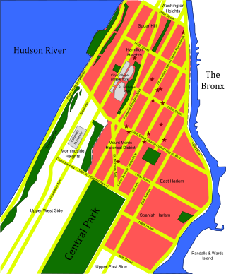
Upper Manhattan is the most northern region of the New York City borough of Manhattan. Its southern boundary has been variously defined, but some of the most common usages are 96th Street, 110th Street, 125th Street, or 155th Street. The term Uptown can refer to Upper Manhattan, but is often used more generally for neighborhoods above 59th Street; in the broader definition, Uptown encompasses Upper Manhattan.

Thirteenth Avenue was a street in the New York City borough of Manhattan, New York City. It was built in 1837 along the Hudson River. The avenue was later removed in the early 20th century to make way for the Chelsea Piers.
Seventh Avenue—co-named Fashion Avenue in the Garment District and known as Adam Clayton Powell Jr. Boulevard north of Central Park—is a thoroughfare on the West Side of the borough of Manhattan in New York City. It is southbound below the park and a two-way street north of it.

The George Washington Bridge Bus Station is a commuter bus terminal at the east end of the George Washington Bridge in the Washington Heights neighborhood of Manhattan in New York City. The bus station is owned and operated by the Port Authority of New York and New Jersey (PANYNJ). On a typical weekday, approximately 20,000 passengers on about 1,000 buses use the station.
Ninth Avenue, known as Columbus Avenue between West 59th and 110th Streets, is a thoroughfare on the West Side of Manhattan in New York City, United States. Traffic runs downtown (southbound) from the Upper West Side to Chelsea. Two short sections of Ninth Avenue also exist in the Inwood neighborhood, carrying two-way traffic.

Tenth Avenue, known as Amsterdam Avenue between 59th Street and 193rd Street, is a north-south thoroughfare on the West Side of Manhattan in New York City. It carries uptown (northbound) traffic as far as West 110th Street, after which it continues as a two-way street.

Interstate 95 (I-95) is part of the Interstate Highway System and runs from Miami, Florida, to the Canada–United States border near Houlton, Maine. In the US state of New York, I-95 extends 23.50 miles (37.82 km) from the George Washington Bridge in New York City to the Connecticut state line at Port Chester. The George Washington Bridge carries I-95 across the Hudson River from New Jersey into New York City. There, I-95 runs across Upper Manhattan on the Trans-Manhattan Expressway for 0.81 miles (1.30 km) through Washington Heights. It continues east across the Harlem River on the Alexander Hamilton Bridge and onto the Cross Bronx Expressway. In the Bronx, I-95 leaves the Cross Bronx at the Bruckner Interchange, joining the Bruckner Expressway to its end. North of the interchange with Pelham Parkway, it then continues northeast via the New England Thruway out of New York City into Westchester County and to the Connecticut state line, where I-95 continues on the Connecticut Turnpike.

Hudson Heights is a residential neighborhood within Washington Heights in Upper Manhattan, New York City. Most residences are apartment buildings, many of which are cooperatives, and most were constructed in the 1920s through 1940s. The Art Deco style is prominent, along with Tudor Revival. Notable complexes include Hudson View Gardens and Castle Village, which were both developed by Dr. Charles V. Paterno, and were designed by George F. Pelham and his son, George F. Pelham, Jr., respectively.

St. Nicholas Avenue is a major street that runs obliquely north-south through several blocks between 111th and 193rd Streets in the New York City borough of Manhattan. The route, which follows a course that is much older than the grid pattern of the Commissioners' Plan of 1811, passes through the neighborhoods of Harlem, Hamilton Heights, and Washington Heights. It is believed to follow the course of an old Indian trail that became an important road in the 17th century between the Dutch settlement of New Amsterdam and the British New England Colonies. In the post colonial era, it became the western end of the Boston Post Road. The road became a street when row housing was being built in Harlem during its rapid urban expansion following the end of the American Civil War.
The Third and Lexington Avenues Line, also known as the Third Avenue Line, is a public transit line in Manhattan, New York City, running from Lower Manhattan to Fort George in Washington Heights. Originally a streetcar line, it now consists of the M98, M101, M102, and M103 bus routes, operated by the New York City Transit Authority. The M98 bus route operates on Third Avenue between East 65th Street and East 127th Street, although it previously continued to 32nd Street. The M101, M102 and M103 bus routes run southbound on Lexington Avenue north of East 24th Street.

The M5 and M55 bus routes constitute a public transit corridor in Manhattan, New York City, running along the Fifth / Sixth Avenues / Riverside Drive Line as well as the southern portion of the Broadway Line after the discontinuation of the M6. The routes primarily run along Broadway, Fifth and Sixth Avenues, and Riverside Drive from South Ferry, Lower Manhattan to Washington Heights. The M5 covers the northern portion of the route north of 31st Street, while the M55 operates along the southern portion of the route south of 44th Street. The two routes overlap in Midtown Manhattan. The portion along Broadway south of East 8th Street was originally a streetcar line.

The M1, M2, M3, and M4 are four local bus routes that operate the Fifth and Madison Avenues Lines – along the one-way pair of Madison and Fifth Avenues in the Manhattan borough of New York City. Though the routes also run along other major avenues, the majority of their route is along Madison and Fifth Avenues between Greenwich Village and Harlem.

Dyckman Street, occasionally called West 200th Street, is a street in the Inwood neighborhood of Manhattan, New York City. It is commonly considered to be a crosstown street because it runs from the Hudson River to the Harlem River and intersects Broadway. However, in its true geographical orientation, Dyckman Street runs roughly from north-northwest to south-southeast, and the majority of the street that lies southeast of Broadway runs closer to a north-south direction than east-west.

Audubon Avenue is an avenue in the Washington Heights neighborhood in Upper Manhattan that runs north-south, west of and parallel to Amsterdam Avenue. Its southern terminus is at West 165th Street and St. Nicholas Avenue, and its northern terminus is at Fort George Avenue, just north of West 193rd Street. It crosses over the Trans-Manhattan Expressway, east of the eastern portal of the expressway's tunnel.

Lafayette Street is a major north–south street in New York City's Lower Manhattan. It originates at the intersection of Reade Street and Centre Street, one block north of Chambers Street. The one-way street then successively runs through Chinatown, Little Italy, NoLIta, and NoHo and finally, between East 9th and East 10th streets, merges with Fourth Avenue. A buffered bike lane runs outside the left traffic lane. North of Spring Street, Lafayette Street is northbound (uptown)-only; south of Spring Street, Lafayette is southbound (downtown)-only.

The 178th and 179th Street Tunnels are two disused vehicular tunnels in Upper Manhattan in New York City. Originally conceived and constructed under the auspices of Robert Moses, the twin tunnels have been superseded by the Trans-Manhattan Expressway in Washington Heights, which itself runs through a cut with high-rise apartments built over it in places.

University Place is a short north-south thoroughfare in the Greenwich Village neighborhood of Manhattan, New York City, United States, which runs from Washington Square Park in the south as a continuation of Washington Square East, taking the position of Madison Avenue uptown, and terminates at East 14th Street just southwest of Union Square. Although the roadway continues north of 14th Street as Union Square West, traffic on the two streets run in opposite directions, both feeding into 14th Street. Until the late 1990s, University Place was a two-way street. The street contains numerous cafes, shops, and restaurants, many of which cater to students at NYU and The New School.

Holyrood Episcopal Church is a Protestant Episcopal Church located at 715 West 179th Street in the Washington Heights neighborhood in upper Manhattan, New York City.
