Broadway is a road in the U.S. state of New York. Broadway runs from the south at State Street at Bowling Green for 13 mi (20.9 km) through the borough of Manhattan, over the Broadway Bridge, and 2 mi (3.2 km) through the Bronx, exiting north from New York City to run an additional 18 mi (29.0 km) through the Westchester County municipalities of Yonkers, Hastings-On-Hudson, Dobbs Ferry, Irvington, Tarrytown, and Sleepy Hollow, after which the road continues, but is no longer called "Broadway". The latter portion of Broadway north of the George Washington Bridge/I-95 underpass comprises a portion of U.S. Route 9.

Houston Street is a major east–west thoroughfare in Lower Manhattan in New York City, United States. It runs the full width of the island of Manhattan, from FDR Drive along the East River in the east to the West Side Highway along the Hudson River in the west. The street is divided into west and east sections by Broadway.
125th Street, co-named Martin Luther King Jr., Boulevard is a two-way street that runs east–west in the New York City borough of Manhattan, from First Avenue on the east to Marginal Street, a service road for the Henry Hudson Parkway along the Hudson River in the west. It is often considered to be the "Main Street" of Harlem.
The 23rd Street Crosstown is a surface transit line on 23rd Street in Manhattan, New York City. It currently hosts the M23 SBS bus route of the Metropolitan Transportation Authority (MTA)'s Regional Bus Operations. The M23 runs between Chelsea Piers, along the West Side Highway near 22nd Street, via 23rd Street, to Avenue C and 20th Street in Stuyvesant Town–Peter Cooper Village.
34th Street is a major crosstown street in the New York City borough of Manhattan. It runs the width of Manhattan Island from the West Side Highway on the West Side to FDR Drive on the East Side. 34th Street is used as a crosstown artery between New Jersey to the west and Queens to the east, connecting the Lincoln Tunnel to New Jersey with the Queens–Midtown Tunnel to Long Island.

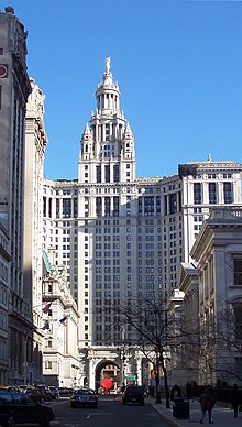
The Civic Center is an area and neighborhood in Lower Manhattan, Manhattan, New York City, that encompasses New York City Hall, One Police Plaza, the courthouses in Foley Square, the Metropolitan Correctional Center, and the surrounding area. The district is bound on the west by Tribeca at Broadway, on the north by Chinatown at Worth Street or Bayard Street, on the east by the East River and the Brooklyn Bridge at South Street, and on the south by the Financial District at Ann Street.
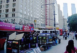
59th Street is a crosstown street in the New York City borough of Manhattan, running from York Avenue and Sutton Place on the East Side of Manhattan to the West Side Highway on the West Side. The three-block portion between Columbus Circle and Grand Army Plaza is known as Central Park South, since it forms the southern border of Central Park. There is a gap in the street between Ninth Avenue/Columbus Avenue and Columbus Circle, where the Deutsche Bank Center is located. While Central Park South is a bidirectional street, most of 59th Street carries one-way traffic.

50th Street is a street in the New York City borough of Manhattan. The street runs eastbound from 12th Avenue, across the full width of the island, ending at Beekman Place.
116th Street runs from Riverside Drive, overlooking the Hudson River, to the East River, through the New York City borough of Manhattan. It traverses the neighborhoods of Morningside Heights, Harlem, and Spanish Harlem; the street is interrupted between Morningside Heights and Harlem by Morningside Park.

The B52 is a bus route that constitutes a public transit line operating in Brooklyn, New York City, running mostly along Fulton Street, Greene Avenue, and Gates Avenue between Downtown Brooklyn and Ridgewood, Queens. The B52 is operated by the MTA New York City Transit Authority. Its precursor was a streetcar line that began operation by 1874, and was known as the Greene and Gates Avenues Line. The route became a bus line in 1941.
The Sixth Avenue Line was a public transit line in Manhattan, New York City, running mostly along Sixth Avenue from Lower Manhattan to Central Park. Originally a streetcar line and later a bus route, it has been absorbed into the M5 bus route, which replaced the Broadway Line, as its northbound direction.

The Eighth Avenue Line is a public transit line in Manhattan, New York City, running mostly along Eighth Avenue from Lower Manhattan to Harlem. Originally a streetcar line, it is now the M10 bus route and the M20 bus route, operated by the New York City Transit Authority. The M10 bus now only runs north of 57th Street, and the M20 runs south of 66th Street. The whole line was a single route, the M10, until 2000 when the M20 was created.

The M22 bus route constitutes a public transit line in Manhattan, New York City. The M22 operates between Battery Park City and the Lower East Side, serving as a crosstown route along Madison Street and Chambers Street.

Varick Street runs north–south primarily in the Hudson Square district of Lower Manhattan in New York City, United States. Varick Street's northern terminus is in the West Village, where it is a continuation of Seventh Avenue South south of Clarkson Street. It continues downtown through Hudson Square and TriBeCa until it reaches Leonard Street, where it merges with West Broadway. Motor traffic is one-way southbound. Major east–west streets crossed include Houston Street and Canal Street. Approaching Broome Street, the two rightmost lanes of Varick Street are reserved for traffic entering the Holland Tunnel, where backups often occur at rush hour.

West Broadway is a north-south street in the New York City borough of Manhattan, separated into two parts by Tribeca Park. The northern part begins at Tribeca Park, near the intersection of Avenue of the Americas, Walker Street and Beach Street in Tribeca. It runs northbound as a one-way street past Canal Street and becomes two-way at the intersection with Grand Street one block farther north. West Broadway then operates as a main north-south thoroughfare through SoHo until its northern end at Houston Street, on the border between SoHo and Greenwich Village. North of Houston Street, it is designated as LaGuardia Place, which continues until Washington Square South.
Washington Street is a north–south street in the New York City borough of Manhattan. It runs in several distinct pieces, from its northernmost end at 14th Street in the Meatpacking District to its southern end at Battery Place in Battery Park City. Washington Street is, for most of its length, the westernmost street in lower Manhattan other than West Street. The exceptions are a one-block segment in the West Village where Weehawken Street lies between West and Washington Streets, and in Battery Park City.

Greenwich Street is a north–south street in the New York City borough of Manhattan. It extends from the intersection of Ninth Avenue and Gansevoort Street in the Meatpacking District at its northernmost end to its southern end at Battery Park. Greenwich Street runs through the Meatpacking District, the West Village, Hudson Square, and Tribeca.
Spanish Transportation, officially Spanish Transportation Service Corporation, and operating under the name Express Service, is a privately operated bus company, which leases minibuses to individual operators, who provide service in and between various communities in northeastern New Jersey and to Manhattan in New York City. The fleet consists mostly of jitneys, often called "the Spanish bus" or "dollar vans" by their English-speaking users, or guaguas by their majority-Spanish clientele.

The M79 Select Bus Service, formerly the 79th Street Crosstown Line, is a bus line in Manhattan, New York City, running mostly along 79th Street on the Upper West and Upper East Sides of Manhattan. The route was previously owned by the private Green Bus Lines, and is now operated by MTA Regional Bus Operations under the New York City Transit Authority brand.

The M31 and M57 bus routes constitute the 57th Street Crosstown Line, a public transit line in Manhattan, New York City, running primarily along 57th Street. The M31 runs between 11th Avenue and 54th Street in Hell's Kitchen to 1st Avenue and 92nd Street in Yorkville. The M57 runs from 72nd Street and Amsterdam Avenue in the Upper West Side to Sutton Place and 57th Street in Sutton Place.