Beaver Street (Manhattan)

Last updated

Beaver Street is a street in the Financial District of Lower Manhattan in New York City. [1] Beaver Street runs five blocks from Pearl Street in the east to Broadway in the west. Along its length, it crosses Hanover, William, Broad, and New Streets. [2] The street is preserved as part of the New Amsterdam street grid, a New York City designated landmark. [3] :2

Contents

History

In the 17th century city of New Amsterdam, the Dutch created two canals, one at present-day Broad Street and one at present-day Beaver Street. [4] The latter originally existed as two separate tributaries of the Broad Street canal; the section west of modern-day Broad Street was called Bever Graft or Beaver Canal, [5] [6] :6 while the section to the east was called De Prince Graft or Prince Canal, [6] :52 which ended in a ditch that the Dutch called a "sloot". [5] Despite the fact that Prince Canal became Princes Street (later Beaver Street), Prince Graft was a name referring to a canal on Broad Street, not Beaver Street. [3] :10 [6] :52

Dutch withdrawal Stuyvesantcap.jpg
Dutch withdrawal

Beaver Street was created by 1658, and possibly as early as 1639, as part of the street plan for New Amsterdam as recorded in the Castello Plan. [3] :9 The modern-day street incorporates parts of three colonial streets: Beaver Street, Princes Street, and the Sloot (later Merchant Street). [3] :9 [6] :51–52 The modern name comes from the section between Broadway and Broad Streets, which was named in the 1660s for beaver pelts that were economically important to New Amsterdam. [1] [3] :9 It was here that a tavern called The Sign of the Lion was located. [7]

The section from Broad to William Street, originally Prince Canal, was known as Prince Street by 1660. [3] :9 [6] :36 On September 8, 1664, the Dutch forces marched out of Fort Amsterdam with all battle honors and proceeded down Beaver Street to embark on board the Gideon bound for the Netherlands, thus transferring the colony of New Netherland to English control. [8]

Willett preventing removal of arms by the British - J.W. Dunsmore, 1907 Marinus Willett preventing removal of arms by the British, June 6th, 1775 - John Ward Dunsmore, 1907. LCCN95505053.jpg
Willett preventing removal of arms by the British - J.W. Dunsmore, 1907

In 1682, a synagogue opened in a house on Beaver Street between Broadway and Broad Street, the first in the city [9] and one of the first in the Thirteen Colonies. [10] The canal west of Broad Street continued to exist until 1684. By 1693, what had been Beaver Canal was known as Beaver Street. [3] :9 The eastern tributary was renamed Princes Street by 1695, Princess Street by 1711, and Carmer Street by 1767. The section east of William Street was known as Sloat Lane (also known as Slote Lane and the Sloot) by 1730 and later became known as Merchant Street. [3] :9 On June 6, 1775, the British garrison withdrew to warships in the harbor. Marinus Willett and others confronted them at the intersection of Broad and Beaver Streets and confiscated a number of carts loaded with arms to prevent them being taken back to the ships. The five carts were driven up Beaver Street to Broadway, then to the John Street property of Abraham Van Wyck, son-in-law of Pierre Van Cortlandt. [11]

Architecture

A photo of Beaver Street in Manhattan, New York City Beaver Street Manhattan 001.JPG
A photo of Beaver Street in Manhattan, New York City

The western end of Beaver Street contains the Standard Oil Building at 26 Broadway. [12] Built as a nine-story building in 1885, [12] :2 [13] [14] the building was expanded by several stories in 1895. [12] :2 [15] [16] The current 31-story structure, completed in 1928 as part of another expansion, replacing a Childs Restaurants location among other businesses. [12] :3 [17] The building is designated as a New York City landmark. [18]

The American Bank Note Company Office Building is at 70 Broad Street, on the southwest corner of Beaver Street. The building was erected in 1908 as the home of the American Bank Note Company, a leading engraving company that produced banknotes, currency, stamps, and stock certificates. It is a New York City landmark and on the National Register of Historic Places. [19] As of 2018, the building was being marketed for residential use. [20]

The Delmonico's Building is located at 56 Beaver Street, at the southwest corner of South William Street. Housing a location of Delmonico's Restaurant, it is an eight-story brick building completed in 1891. [21] [22] Delmonico's was intended to complement the New York Cotton Exchange building of 1883–1885, across the street. [22] It is a New York City designated landmark. [23]

At the eastern end of Beaver Street, where it merges with Pearl Street, is 1 Wall Street Court. Constructed between 1903 and 1904 as a speculative development, it is a New York City landmark and on the National Register of Historic Places. [24] 1 Wall Street Court was originally known as the Beaver Building and contained the offices of the Munson Line, a steamship-line company in the Americas. [25] The building also served as the home of the New York Cocoa Exchange from 1931 [26] [27] to 1972. [28] It was turned into residential condominiums by 2006. [29] [30]

Related Research Articles

<span class="mw-page-title-main">Morningside Heights</span> Neighborhood of Manhattan in New York City

Morningside Heights is a neighborhood on the West Side of Upper Manhattan in New York City. It is bounded by Morningside Drive to the east, 125th Street to the north, 110th Street to the south, and Riverside Drive to the west. Morningside Heights borders Central Harlem and Morningside Park to the east, Manhattanville to the north, the Manhattan Valley section of the Upper West Side to the south, and Riverside Park to the west. Broadway is the neighborhood's main thoroughfare, running north–south.

<span class="mw-page-title-main">Financial District, Manhattan</span> Neighborhood of Manhattan in New York City

The Financial District of Lower Manhattan, also known as FiDi, is a neighborhood located on the southern tip of Manhattan in New York City. It is bounded by the West Side Highway on the west, Chambers Street and City Hall Park on the north, Brooklyn Bridge on the northeast, the East River to the southeast, and South Ferry and the Battery on the south.

<span class="mw-page-title-main">New York City Landmarks Preservation Commission</span> Agency charged with administering New York Citys Landmarks Preservation Law

The New York City Landmarks Preservation Commission (LPC) is the New York City agency charged with administering the city's Landmarks Preservation Law. The LPC is responsible for protecting New York City's architecturally, historically, and culturally significant buildings and sites by granting them landmark or historic district status, and regulating them after designation. It is the largest municipal preservation agency in the nation. As of July 1, 2020, the LPC has designated more than 37,000 landmark properties in all five boroughs. Most of these are concentrated in historic districts, although there are over a thousand individual landmarks, as well as numerous interior and scenic landmarks.

<span class="mw-page-title-main">New Amsterdam Theatre</span> Broadway theater in Manhattan, New York

The New Amsterdam Theatre is a Broadway theater on 214 West 42nd Street, at the southern end of Times Square, in the Theater District of Manhattan in New York City. One of the first Broadway venues to open in the Times Square neighborhood, the New Amsterdam was built from 1902 to 1903 to designs by Herts & Tallant. The theater is operated by Disney Theatrical Productions and has 1,702 seats across three levels. Both the Beaux-Arts exterior and the Art Nouveau interior of the building are New York City landmarks, and the building is on the National Register of Historic Places.

<span class="mw-page-title-main">Whitehall Street</span> Street in Manhattan, New York

Whitehall Street is a street in the South Ferry/Financial District neighborhood of Lower Manhattan in New York City, near the southern tip of Manhattan Island. The street begins at Bowling Green to the north, where it is a continuation of the southern end of Broadway. Whitehall Street stretches four blocks to the southern end of FDR Drive, adjacent to the Staten Island Ferry's Whitehall Terminal, on landfill beyond the site of Peter Stuyvesant's 17th-century house.

<span class="mw-page-title-main">Broad Street (Manhattan)</span> Street in Manhattan, New York

Broad Street is a north–south street in the Financial District of Lower Manhattan in New York City. Originally the Broad Canal in New Amsterdam, it stretches from today's South Street to Wall Street.

<span class="mw-page-title-main">University Heights Bridge</span> Bridge between Manhattan and the Bronx, New York

The University Heights Bridge is a steel-truss revolving swing bridge across the Harlem River in New York City. It connects West 207th Street in the Inwood neighborhood of Manhattan with West Fordham Road in the University Heights neighborhood of the Bronx. The bridge is operated and maintained by the New York City Department of Transportation.

<span class="mw-page-title-main">1 Wall Street Court</span> Residential building in Manhattan, New York

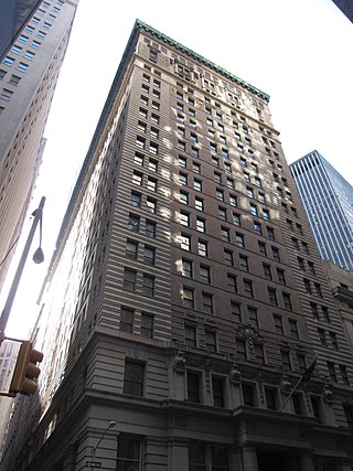
1 Wall Street Court is a residential building in the Financial District of Manhattan in New York City. The 15-story building, designed by Clinton and Russell in the Renaissance Revival style, was completed in 1904 at the intersection of Wall, Pearl, and Beaver Streets.

<span class="mw-page-title-main">William Street (Manhattan)</span> Street in Manhattan, New York

William Street is a street in the Financial District of Lower Manhattan, New York City. It runs generally southwest to northeast, crossing Wall Street and terminating at Broad Street and Spruce Street, respectively. Between Beaver Street and Broad Street, the street is known as South William Street. Between Beekman Street and Spruce Street, in front of New York Downtown Hospital, William Street is a pedestrian-only street.

<span class="mw-page-title-main">Stone Street (Manhattan)</span> Street in Manhattan, New York

Stone Street is a short street in the Financial District of Manhattan in New York City. It runs in two sections between Whitehall Street in the west and Hanover Square in the east. The street originally ran as one continuous roadway from Whitehall Street to Hanover Square, but the section between Broad Street and Coenties Alley was eliminated in 1980 to make way for the Goldman Sachs building at 85 Broad Street. The one-block-long western section between Whitehall and Broad Streets carries vehicular traffic, while the two-block-long eastern section between Coenties Alley and Hanover Square is a pedestrian zone.

<span class="mw-page-title-main">65 Broadway</span> Office skyscraper in Manhattan, New York

65 Broadway, formerly the American Express Building, is a building on Broadway between Morris and Rector Streets in the Financial District of Manhattan in New York City. The 21-story concrete and steel-frame structure, an office building, was designed by James L. Aspinwall of the firm Renwick, Aspinwall & Tucker in the Neoclassical style. 65 Broadway extends westward through an entire block, to Trinity Place. Its most prominent feature is its H-shaped building plan, with light courts located between its wings.

<span class="mw-page-title-main">195 Broadway</span> Office skyscraper in Manhattan, New York

195 Broadway, also known as the Telephone Building, Telegraph Building, or Western Union Building, is an early skyscraper on Broadway in the Financial District of Manhattan, New York City. It was the longtime headquarters of AT&T as well as Western Union. It occupies the entire western side of Broadway from Dey Street to Fulton Street.

<span class="mw-page-title-main">American Bank Note Company Building</span> Building in Manhattan, New York

The American Bank Note Company Building is a five-story building at 70 Broad Street in the Financial District of Manhattan in New York City. The building was designed by architects Kirby, Petit & Green in the neo-classical style, and contains almost 20,000 square feet (1,900 m2) of space, with offices and residences on the upper floors. The exterior consists of a main facade on Broad Street with two columns, as well as side facades with pilasters on Beaver and Marketfield Streets.

<span class="mw-page-title-main">Broad Exchange Building</span> Residential skyscraper in Manhattan, New York

The Broad Exchange Building, also known as 25 Broad Street, is a residential building at Exchange Place and Broad Street in the Financial District of Lower Manhattan in New York City. The 20-story building was designed by Clinton & Russell and built between 1900 and 1902. The Alliance Realty Company developed the Broad Exchange Building as a speculative development for office tenants.

<span class="mw-page-title-main">26 Broadway</span> Office skyscraper in Manhattan, New York

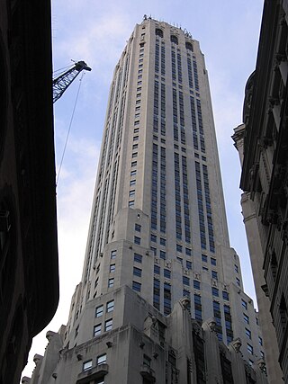
26 Broadway, also known as the Standard Oil Building or Socony–Vacuum Building, is an office building adjacent to Bowling Green in the Financial District of Lower Manhattan in New York City. The 31-story, 520-foot-tall (160 m) structure was designed in the Renaissance Revival style by Thomas Hastings of Carrère and Hastings, in conjunction with Shreve, Lamb & Blake. It was built as the headquarters of Standard Oil, once one of the largest oil companies in the United States.

<span class="mw-page-title-main">Wall Street Historic District (Manhattan)</span> Historic district in New York City

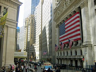
The Wall Street Historic District in New York City includes part of Wall Street and parts of nearby streets in the Financial District in lower Manhattan. It includes 65 contributing buildings and one contributing structure over a 63-acre (25 ha) listed area.

<span class="mw-page-title-main">Mutual Reserve Building</span> Office building in Manhattan, New York

The Mutual Reserve Building, also known as the Langdon Building and 305 Broadway, is an office building at Broadway and Duane Street in the Tribeca neighborhood of Manhattan in New York City. The 13-story building, constructed between 1892 and 1894, was designed by William H. Hume and built by Richard Deeves, with Frederick H. Kindl as chief structural engineer. It is just east of the Civic Center of Manhattan, and carries the addresses 305–309 Broadway and 91–99 Duane Street.

<span class="mw-page-title-main">Exchange Place (Manhattan)</span> Street in Manhattan, New York

Exchange Place is a street in the Financial District of Lower Manhattan, New York City. The street runs five blocks between Trinity Place in the west and Hanover Street in the east.

<span class="mw-page-title-main">Apple Bank Building</span> Bank and apartment building in Manhattan, New York

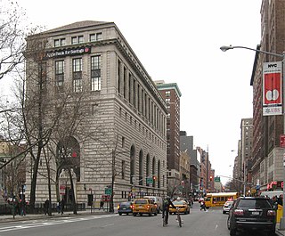
The Apple Bank Building, also known as the Central Savings Bank Building and 2100 Broadway, is a bank and residential building at 2100–2114 Broadway on the Upper West Side of Manhattan in New York City. Constructed as a branch of the Central Savings Bank from 1926 to 1928, it occupies a trapezoidal city block bounded by 73rd Street to the south, Amsterdam Avenue to the east, 74th Street to the north, and Broadway to the west. The Apple Bank Building was designed by York and Sawyer in the Renaissance Revival and palazzo styles, patterned after an Italian Renaissance-style palazzo.

<span class="mw-page-title-main">56 Beaver Street</span> Building in Manhattan, New York

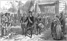
56 Beaver Street is a structure in the Financial District of Manhattan in New York City, United States. Designed by James Brown Lord, the building was completed in 1891 as a location of the Delmonico's restaurant chain. The current building, commissioned by Delmonico's chief executive Charles Crist Delmonico, replaced Delmonico's first building on the site, which had been built in 1837. The building is a New York City designated landmark and a contributing property to the Wall Street Historic District, a National Register of Historic Places district.

References

  1. 1 2 "BEAVER STREET, Financial District". Forgotten New York. January 10, 2015. Retrieved March 1, 2020.
  2. "NYCityMap". NYC.gov. New York City Department of Information Technology and Telecommunications . Retrieved March 20, 2020.
  3. 1 2 3 4 5 6 7 8 "Street Plan of New Amsterdam and Colonial New York" (PDF). New York City Landmarks Preservation Commission. June 14, 1983. Archived (PDF) from the original on December 23, 2016. Retrieved August 13, 2021.
  4. Kadinsky, Sergey (2016). Hidden Waters of New York City: A History and Guide to 101 Forgotten Lakes, Ponds, Creeks, and Streams in the Five Boroughs. New York, NY: Countryman Press. pp. 20–21. ISBN   978-1-58157-566-8.
  5. 1 2 Benson, Egbert; New-York Historical Society (1825). Memoir Read Before the Historical Society of the State of New-York, December 31, 1816. Henry C. Sleight. p. 79.
  6. 1 2 3 4 5 Post, John J (1882). "Old streets, roads, lanes, piers and wharves of New York. Showing the former and present names, together with a list of alterations of streets, either by extending, widening, narrowing or closing". R. D. Cooke. Archived from the original on April 10, 2016 via Internet Archive.
  7. Valentine, David Thomas. History of the city of New-York, G.P. Putnam & Company, 1853, p. 37 PD-icon.svg This article incorporates text from this source, which is in the public domain .
  8. O'Callaghan, Edmund Bailey. History of New Netherland: Or, New York Under the Dutch, Vol. 2, 1848, p. 536 PD-icon.svg This article incorporates text from this source, which is in the public domain .
  9. Levinger, Lee (2007). A History of the Jews in the United States. Wildside Press. p. 66. ISBN   978-1-4344-8698-1.
  10. Scharfstein, Sol (1999). Understanding Jewish Holidays and Customs: Historical and Contemporary. Ktav Publishing House. p. 134. ISBN   978-0-88125-626-0 . Retrieved August 13, 2021.
  11. Willett, William Marinus. A Narrative of the Military Actions of Colonel Marinus Willett, G. & C. & H. Carvill, 1831, p. 29 et seq PD-icon.svg This article incorporates text from this source, which is in the public domain .
  12. 1 2 3 4 "Standard Oil Building" (PDF). New York City Landmarks Preservation Commission. September 19, 1995. Retrieved August 13, 2021.
  13. "Standard Oil Company Building". The New York Times. April 3, 1884. ISSN   0362-4331. Archived from the original on January 31, 2020. Retrieved August 13, 2021.
  14. Landau, Sarah; Condit, Carl W. (1996). Rise of the New York Skyscraper, 1865–1913 . New Haven, CT: Yale University Press. pp. 133–134. ISBN   978-0-300-07739-1. OCLC   32819286.
  15. "Standard Oil Company Preparing to Erect Twenty-seven Story Structure on Broadway". The New York Times. March 6, 1921. ISSN   0362-4331. Archived from the original on February 3, 2020. Retrieved August 13, 2021.
  16. Brown, Charles R. (1897). "Engineering Problems of the Tall Building". Engineering Magazine. Vol. 13. p. 413 via Internet Archive.
  17. Stern, Robert A. M.; Gilmartin, Patrick; Mellins, Thomas (1987). New York 1930: Architecture and Urbanism Between the Two World Wars. New York: Rizzoli. pp. 539–540. ISBN   978-0-8478-3096-1. OCLC   13860977.
  18. Dunlap, David W. (October 15, 1995). "Bringing Downtown Back Up". The New York Times. ISSN   0362-4331. Archived from the original on January 30, 2020. Retrieved August 13, 2021.
  19. "Historic Structures Report: American Bank Note Company Building" (PDF). National Register of Historic Places, National Park Service. November 30, 1999. Retrieved August 13, 2021.
    "American Bank Note Company Office Building" (PDF). New York City Landmarks Preservation Commission. June 24, 1997. Retrieved August 13, 2021.
  20. Alexa, Alexandra (December 3, 2018). "In the market for a palace? This massive FiDi landmark is 50% off". 6sqft. Retrieved August 13, 2021.
  21. "Delmonico's Steak House NYC 10004". Delmonico's Steak House NYC 10004. Retrieved March 1, 2020.
  22. 1 2 Stern, Robert A. M.; Mellins, Thomas; Fishman, David (1999). New York 1880: Architecture and Urbanism in the Gilded Age. Monacelli Press. p. 734. ISBN   978-1-58093-027-7. OCLC   40698653.
  23. "Delmonico's Building" (PDF). New York City Landmarks Preservation Commission. February 13, 1996. Retrieved August 13, 2021.
  24. "Historic Structures Report: Beaver Building" (PDF). National Register of Historic Places, National Park Service. July 6, 2005. Retrieved August 13, 2021.
    "Beaver Building" (PDF). New York City Landmarks Preservation Commission. February 13, 1996. Retrieved August 13, 2021.
  25. "Munson Building Opens; Steamship Company Completes Project Begun a Year Ago". The New York Times. May 8, 1921. ISSN   0362-4331 . Retrieved August 13, 2021.
  26. "N.Y. Cocoa Exchange Going to New Home". Brooklyn Daily Eagle. April 25, 1931. p. 23. Retrieved August 13, 2021.
  27. "Cocoa Exchange Moves To New Trading Quarters". The New York Times. April 26, 1931. ISSN   0362-4331 . Retrieved August 13, 2021.
  28. Ennis, Thomas W. (May 2, 1972). "Cocoa Unit Opens at New Quarters". The New York Times. ISSN   0362-4331 . Retrieved August 13, 2021.
  29. "1 Wall Street Court". CCM. Retrieved August 13, 2021.
  30. "Development Du Jour: The Cocoa Exchange". Curbed NY. April 19, 2006. Retrieved August 13, 2021.