Delancey Street

Last updated
Template:Attached KML/Delancey Street
KML is from Wikidata
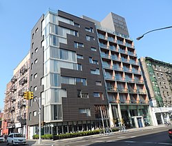
Delancey Street and the Blue Condominium from Suffolk Street looking west Blue Condominium Tower Neighborhood.jpg
Delancey Street and the Blue Condominium from Suffolk Street looking west

Delancey Street is one of the main thoroughfares of New York City's Lower East Side in Manhattan, running from the street's western terminus at the Bowery to its eastern end at FDR Drive, connecting to the Williamsburg Bridge and Brooklyn at Clinton Street. It is an eight-lane, median-divided street, which is west of Clinton Street, and a service road for the Williamsburg Bridge east of Clinton Street. West of Bowery, Delancey Street becomes Kenmare Street, which continues as a four-lane, undivided street to Lafayette Street.

Contents

Delancey Street is named after James De Lancey Sr., chief justice, lieutenant governor, and acting colonial governor of the Province of New York, whose farm was located in what is now called the Lower East Side. There is also a Delancey Street in Camden Town, London, England, a residential street named after another James Delancey, of Marylebone, who had a number of fields west of the High Street. [1]

Businesses range from delis to check-cashing stores to bars. Delancey Street has long been known for its discount and bargain clothing stores. Famous establishments include the Bowery Ballroom, built in 1929, Ratner's kosher restaurant (now closed), and the Essex Street Market, which was built by Mayor Fiorello La Guardia to avoid pushcart congestion on the neighborhood's narrow streets.

Until the middle 20th century, Delancey Street was a main shopping street in the predominantly Jewish and Irish Lower East Side. Since the late 2000s, the neighborhood around Delancey is more diverse; including African Americans, Puerto Ricans, Dominicans, and Chinese. Gentrification has brought more upscale retail and nightlife establishments.[ citation needed ]

Transportation

The New York City Subway's F , <F> , J , M , and Z trains serve the Delancey Street/Essex Street station, and the J and Z trains also stop at the Bowery station.

Under New York City Bus, the B39 is Delancey Street’s main bus, running between Allen & Clinton Streets. In addition, the M14D SBS and M21 run in the westbound direction to Columbia Street, where the former terminates, from the FDR Drive and Lewis Street, respectively (eastbound M21 buses cross on the FDR Drive). The M9 and M14A SBS cross on Essex Street, the M15 and M15 SBS on Allen Street, and the M103 on Bowery. [2]

The Williamsburg Bridge Trolley Terminal, beneath Delancey and Essex Streets, was a station and balloon loop for streetcars crossing the Williamsburg Bridge from Brooklyn. The Lowline, an underground public park in which natural light would be directed using fiber optics to create a setting in which trees and grass could be grown indoors, was proposed in 2011. [3] [4]

Because Delancey Street is very wide, and because of its high rate of fatalities, safety measures were erected along its length in the 2000s and 2010s. This includes pedestrian plazas, bans on left turns along the street, and pedestrian countdown signals. [5] A protected bike lane was constructed on Delancey Street from Chrystie Street to the Williamsburg Bridge in November 2018, in advance of the 14th Street Tunnel shutdown. [6] In January 2023, city officials received a $21 million grant from the federal government to add bike lanes, widen sidewalks, and reduce vehicular lanes along Delancey Street. [7]

Kenmare Street

Nolita Hotel, Kenmare and Elizabeth Streets Nolita Hotel 153 Elizabeth and Kenmare sunny jeh.JPG
Nolita Hotel, Kenmare and Elizabeth Streets

Kenmare Street extends five blocks from the Bowery to Lafayette Street. It is a major thoroughfare for traffic traveling westbound to the Holland Tunnel. The street was founded in 1911, by Tim Sullivan, the son of immigrants Daniel O’Sullivan and Catherine Connelly, who came from Kenmare, County Kerry, Ireland. [8]

Related Research Articles

<span class="mw-page-title-main">Houston Street</span> Street in Manhattan, New York

Houston Street is a major east–west thoroughfare in Lower Manhattan in New York City, United States. It runs the full width of the island of Manhattan, from FDR Drive along the East River in the east to the West Side Highway along the Hudson River in the west. The street is divided into west and east sections by Broadway.

<span class="mw-page-title-main">Lower East Side</span> Neighborhood in New York City

The Lower East Side, sometimes abbreviated as LES, is a historic neighborhood in the southeastern part of Manhattan in New York City. It is located roughly between the Bowery and the East River from Canal to Houston streets. Historically, it was understood to encompass a much larger area, from Broadway to the East River and from East 14th Street to Fulton and Franklin Streets.

<span class="mw-page-title-main">Canal Street (Manhattan)</span> Street in Manhattan, New York

Canal Street is a major east–west street of over 1 mile (1.6 km) in Lower Manhattan, New York City, United States, running from East Broadway between Essex and Jefferson Streets in the east, to West Street between Watts and Spring Streets in the west. It runs through the neighborhood of Chinatown, and forms the southern boundaries of SoHo and Little Italy as well as the northern boundary of Tribeca. The street acts as a major connector between Jersey City, New Jersey, via the Holland Tunnel (I-78), and Brooklyn in New York City via the Manhattan Bridge. It is a two-way street for most of its length, with two unidirectional stretches between Forsyth Street and the Manhattan Bridge.

<span class="mw-page-title-main">Second Avenue (Manhattan)</span> North-south avenue in Manhattan, New York

Second Avenue is located on the East Side of the New York City borough of Manhattan extending from Houston Street at its south end to the Harlem River Drive at 128th Street at its north end. A one-way street, vehicular traffic on Second Avenue runs southbound (downtown) only, except for a one-block segment of the avenue in Harlem. South of Houston Street, the roadway continues as Chrystie Street south to Canal Street.

<span class="mw-page-title-main">125th Street (Manhattan)</span> West-east street in Manhattan, New York

125th Street, co-named Martin Luther King Jr., Boulevard is a two-way street that runs east–west in the New York City borough of Manhattan, from First Avenue on the east to Marginal Street, a service road for the Henry Hudson Parkway along the Hudson River in the west. It is often considered to be the "Main Street" of Harlem.

<span class="mw-page-title-main">M23 (New York City bus)</span> Bus route in Manhattan, New York

The 23rd Street Crosstown is a surface transit line on 23rd Street in Manhattan, New York City. It currently hosts the M23 SBS bus route of the Metropolitan Transportation Authority (MTA)'s Regional Bus Operations. The M23 runs between Chelsea Piers, along the West Side Highway near 22nd Street, via 23rd Street, to Avenue C and 20th Street in Stuyvesant Town–Peter Cooper Village.

<span class="mw-page-title-main">First Avenue (Manhattan)</span> North-south avenue in Manhattan, New York

First Avenue is a north-south thoroughfare on the East Side of the New York City borough of Manhattan, running from Houston Street northbound to 127th Street. At 125th Street, most traffic continues onto the Willis Avenue Bridge over the Harlem River, which continues into the Bronx. South of Houston Street, the roadway continues as Allen Street south to Division Street. Traffic on First Avenue runs northbound (uptown) only.

<span class="mw-page-title-main">DeKalb Avenue</span> Avenue in Brooklyn, New York

DeKalb Avenue is a thoroughfare in the New York City boroughs of Brooklyn and Queens, with the majority of its length in Brooklyn.

<span class="mw-page-title-main">Delancey Street/Essex Street station</span> New York City Subway station in Manhattan

The Delancey Street/Essex Street station is a station complex shared by the BMT Nassau Street Line and the IND Sixth Avenue Lines of the New York City Subway, located at the intersection of Essex and Delancey Streets on the Lower East Side of Manhattan, just west of the Williamsburg Bridge. It is served by the:

The B44 is a public transit line in Brooklyn, New York City, running mostly along Nostrand Avenue, as well as northbound on Rogers Avenue or New York Avenue and Bedford Avenue, between Sheepshead Bay and Williamsburg. Originally a streetcar line, it is now the B44 bus route, operated by the New York City Transit Authority.

<span class="mw-page-title-main">M8 (New York City bus)</span> Bus route in Manhattan, New York

The Eighth and Ninth Streets Crosstown is a public transit line in Manhattan, New York City, running mostly along Eighth Street, Ninth Street, Tenth Street, and Christopher Street through the West Village, Greenwich Village, and East Village. Originally a streetcar line, it is now the M8 bus route, operated by the Manhattan and Bronx Surface Transit Operating Authority.

<span class="mw-page-title-main">M14 (New York City bus)</span> Bus routes in Manhattan, New York

The 14th Street Crosstown Line is a public transit line in Manhattan, New York City, running primarily along 14th Street from Chelsea or the West Village to the Lower East Side. Originally a streetcar line, it is now the M14 bus route, operated by the Manhattan and Bronx Surface Transit Operating Authority. The line's two variants, the M14A SBS and M14D SBS, use Avenue A and Avenue D respectively from 14th Street south into the Lower East Side.

<span class="mw-page-title-main">M9 (New York City bus)</span> Bus route in Manhattan, New York

The M9 is a local bus route that operates along the Avenue C Line, in Manhattan, New York City. The M9 and M21 are operated by the Manhattan and Bronx Surface Transit Operating Authority, and based out of the Michael J. Quill Depot.

<span class="mw-page-title-main">M21 (New York City bus)</span> Bus route in Manhattan, New York

The M21 bus route constitutes a public transit line in Manhattan, New York City. The M21 operates between the West Village and the Lower East Side, serving as a Houston Street crosstown. The M9 and M21 are operated by the Manhattan and Bronx Surface Transit Operating Authority, and based out of the Michael J. Quill Depot.

<span class="mw-page-title-main">Grand Street (Manhattan)</span> Street in Manhattan, New York

Grand Street is a street in Lower Manhattan, New York City. It runs west/east parallel to and south of Delancey Street, from SoHo through Chinatown, Little Italy, the Bowery, and the Lower East Side. The street's western terminus is Varick Street, and on the east it ends at the service road for the FDR Drive.

<span class="mw-page-title-main">Flushing Avenue</span> Avenue in Brooklyn and Queens, New York

Flushing Avenue is a street running through northern Brooklyn and western Queens, beginning at Nassau Street in Fort Greene, Brooklyn, and ending at Grand Avenue in Maspeth. It divides the neighborhood of Williamsburg from Clinton Hill and East Williamsburg from Bushwick. After crossing the Queens border, the avenue serves as the dividing line between Ridgewood, Queens and West Maspeth. Flushing Avenue then terminates in Maspeth. Despite its name, however, the avenue does not extend to Flushing.

<span class="mw-page-title-main">Allen Street</span> Street in Manhattan, New York

Allen Street is a street in the New York City borough of Manhattan which runs north-south through the Lower Manhattan neighborhood of Chinatown and the Lower East Side. It is continued north of Houston Street as First Avenue. South of Division Street, it is known as Pike Street to its southern terminus at South Street. The northbound and southbound roadways are separated by a meridian mall, which has two bike lanes located outside the meridian mall; each bike lane is unidirectional. The street's namesake was Master Commandant William Henry Allen, the youngest person to command a Navy ship in the War of 1812. He was killed in action at the age of 28. His exploits included the capture of the British ship HMS Macedonian.

<span class="mw-page-title-main">Williamsburg Bridge Trolley Terminal</span> Former terminal in Manhattan, New York

The Williamsburg Bridge Trolley Terminal, also called the Essex Street Trolley Terminal or Delancey Street Trolley Terminal, was a trolley terminal located underground adjacent to the Essex Street subway station in the Lower East Side of Manhattan. Passenger trolley service operated through the terminal from 1908 until 1948 when trolley service over the Williamsburg Bridge ended. The station was constructed with balloon loops for turning around streetcars after they crossed over the Williamsburg Bridge to send them back to Brooklyn.

<span class="mw-page-title-main">Bus lanes in New York City</span> Bus priority system

Since 1963, New York City has been using a system of bus lanes that are intended to give priority to buses, which contain more occupants than passenger and commercial vehicles. Most of these lanes are restricted to buses only at certain days and times, but some bus lanes are restricted 24/7. As of May 2021, there are 138.4 miles (222.7 km) of bus lanes within New York City.

<span class="mw-page-title-main">M34 and M34A buses</span> Bus routes in Manhattan, New York

The 34th Street Crosstown Line is a surface transit line on 34th Street in Manhattan, New York City, United States. It currently hosts the M34/M34A SBS routes of MTA's Regional Bus Operations. The M34 runs from 12th Avenue to FDR Drive via 34th Street, while the M34A runs from Port Authority Bus Terminal to Waterside Plaza.

References

Notes

  1. Hayes, David A.; Camden History Society (2020). CAMDEN STREET NAMES and their origins (PDF) (Report).
  2. "Manhattan Bus Map" (PDF). Metropolitan Transportation Authority. July 2019. Retrieved December 1, 2020.
  3. Foderaro, Lisa W. (November 21, 2011). "Inspired by High Line, Park Is Envisioned With Sights Set Low". The New York Times . Retrieved November 21, 2011.
  4. Cohen, Andrew (September 22, 2011). "Plans for Delancey Underground presented to Community Board 3". Bowery Boogie. Archived from the original on September 26, 2011.
  5. "Delancey Street 2012" (PDF). New York City Department of Transportation. February 8, 2012.
  6. Robbins, Christopher (November 15, 2018). "The New Delancey Street Bike Lane Has A Potentially Dangerous Flaw". Gothamist. Retrieved February 2, 2023.
  7. Nessen, Stephen (February 1, 2023). "Delancey Street to get 'road diet' thanks to $21M from feds". Gothamist. Retrieved February 2, 2023.
  8. "The story of how New York's Kenmare St got its name from famine emigrants". Irish Central. March 10, 2017.