Williamsburg Bridge Trolley Terminal

Last updated

Williamsburg Bridge Trolley Terminal
Streetcar terminal
Williamsburg Bridge trolley terminal vc.jpg
The now-closed trolley terminal in 2013.
General information
LocationDelancey Street & Essex Street
New York, NY 10002
United States
Coordinates 40°43′07″N73°59′18″W / 40.71851°N 73.988199°W / 40.71851; -73.988199
Owned by City of New York
Operated by Brooklyn Rapid Transit Company (1908–1923)
New York City Department of Plant and Structures (1923–1931)
Brooklyn–Manhattan Transit Corporation (1931–1940)
New York City Board of Transportation (1940–1948)
Platforms7
Tracks8
Construction
Structure typeUnderground
History
OpenedMay 19, 1908 (1908-05-19)
ClosedDecember 6, 1948 (1948-12-06)
Services
None (abandoned)

The Williamsburg Bridge Trolley Terminal, also called the Essex Street Trolley Terminal or Delancey Street Trolley Terminal, [1] [2] was a trolley terminal located underground adjacent to the Essex Street subway station in the Lower East Side of Manhattan. Passenger trolley service operated through the terminal from 1908 until 1948 when trolley service over the Williamsburg Bridge ended. The station was constructed with balloon loops for turning around streetcars after they crossed over the Williamsburg Bridge to send them back to Brooklyn. [3] [4] [5]

Contents

In 2011 a proposal was made to turn the Williamsburg Bridge Trolley Terminal into the Lowline park. [5] [6] [7]

Layout

A plan of the underground trolley terminal and the adjacent Essex Street subway station. The Street railway journal (1908) (14760357355).jpg
A plan of the underground trolley terminal and the adjacent Essex Street subway station.

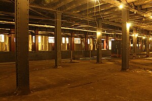
Underground terminal

The trolley terminal is located under the south side of Delancey Street between Clinton Street to the east and Norfolk Street to the west, one block east of Essex Street. The terminal is adjacent to the Brooklyn-bound subway track of the Essex Street subway station. The terminal consisted of eight balloon loops which fed directly into and out of the trolley tracks on the south side of the Williamsburg Bridge, allowing trolleys running over the bridge to reverse direction and return to Brooklyn. The loops were numbered 1 through 8 from west to east. Each loop was assigned to at most two streetcar services. In between the loops were seven low-level island platforms, slightly raised from track level. Each platform had 12 foot-wide staircases leading to the street. Each loop could hold two trolley cars, with a trolley stopping at the west end of the platform to discharge Manhattan-bound passengers, then moving up to the east end to pick up Brooklyn-bound passengers. [1] [2] [3] [4] [8] [9] The terminal was designed with both electrical incandescent lighting and vaults that allowed natural light to enter the station. [3]

Below are the list of routes that served each loop: [3] [4]

Surface terminal

At ground-level was an additional terminal for through-trolley service from the New York Railways Company and Third Avenue Railway, whose lines traveled from Manhattan along the north side of the bridge to the Washington Plaza trolley terminal in Williamsburg, Brooklyn. The covered exit stairs from the subway and underground terminal led directly to the shelters serving the Manhattan surface trolleys. Both the staircases and shelters were designed with terracotta features. The exit stairs were designed as kiosks constructed of concrete, and finished with blue and white tiling. [3]

Transfers

Brooklyn trolley lines which crossed the Williamsburg Bridge and terminated at the terminal included the Belt Line, Broadway Line, Bushwick Avenue Line, Franklin Avenue Line, Grand Street Line, Marcy Avenue Line, Nostrand Avenue Line, Ralph Avenue Line, Sumner Avenue Line, Reid Avenue Line, Tompkins Avenue Line, and Wilson Avenue Line (also called the Hamburg Avenue Line). Several of these lines, including the Franklin, Nostrand, Tompkins, and Reid Lines, traveled via the Culver surface line to the Culver Depot in Coney Island. The Marcy Avenue line traveled to a racetrack in Sheepshead Bay. The Wilson Avenue Line traveled to the resorts in Canarsie. The Grand Street Line, meanwhile, traveled via the Junction Boulevard Line to the North Beach amusement area in northern Queens, now the site of LaGuardia Airport. [1] [3] [4]

History

Williamsburg Bridge and Delancey Street, 1919. Kiosks in center go down to underground trolley terminal; larger one to left goes to subway. Foreground: waiting areas for Manhattan streetcars Essex street trolley terminal.gif
Williamsburg Bridge and Delancey Street, 1919. Kiosks in center go down to underground trolley terminal; larger one to left goes to subway. Foreground: waiting areas for Manhattan streetcars

The Williamsburg Bridge opened on December 19, 1903. [10] [11] In March 1904, it was determined that Brooklyn streetcars operated by the Brooklyn Rapid Transit Company (BRT) would cross the bridge and terminate at Delancey Street, while the Manhattan trolleys of the New York Railways Company would terminate at Washington Plaza in Williamsburg. [12] [13] On November 6, 1904, BRT streetcars including the Reid Avenue Line began crossing the bridge to Lower Manhattan. [14] [15] [16] In 1905, it was decided to build a permanent underground terminal for Brooklyn surface cars and future elevated cars coming from the BRT's Broadway elevated; this station would eventually become the first stop of the BMT Nassau Street Line. [9] [17] The Essex Street trolley terminal was constructed along with the adjoining subway station, but was delayed due to changes in the plans for the subway station. [1] [3] Both stations were constructed using cut-and-cover methods, by excavating Delancey Street. [18] In addition, the approaches of the subway tracks and the southern bridge trolley tracks were lowered into ramps leading to the terminal. [18] As a temporary solution until the terminal was completed, trolleys terminated at stub-end tracks on the street. [3] This setup, however, was inefficient and led to passenger congestion. [18] The underground trolley terminal opened on May 19, 1908, with New York City mayor George B. McClellan Jr. operating the first streetcar over the bridge into the terminal. [4] [18] [19] The new terminal allowed the BRT to double the capacity of its streetcar operations over the bridge. [1] [18]

Construction of a Centre Street Subway Loop to connect the Williamsburg and Manhattan Bridges was begun. It was never completed but rather was incorporated into the BMT Nassau Street Line. [20]

On December 1, 1923, service on the now-Brooklyn–Manhattan Transit Corporation (BMT) lines over the Williamsburg Bridge ended, due to decreasing profits and a dispute with the city over tolls. BMT service was truncated to Washington Plaza in Williamsburg, and bridge service was replaced with municipal shuttle service. [15] [21] [22] [23] On February 15, 1931, BMT streetcars once again began running to Manhattan after municipal shuttle service ended. Only the Nostrand, Ralph, Reid, and Tompkins lines resumed traveling over the bridge, while the remaining lines continued to terminate in Brooklyn. [21] [22] [24] On December 6, 1948, the last of the streetcar lines to run over the bridge, the "Williamsburg Bridge Local" shuttle between the Manhattan and Brooklyn trolley terminals, was converted into the B39 bus route. Afterwards, the Essex Street terminal was closed, and the kiosks to the terminal and subway station were removed from Delancey Street. [25] [26] [27] [28]

Related Research Articles

<span class="mw-page-title-main">Brooklyn–Manhattan Transit Corporation</span> Defunct transit operator in New York City

The Brooklyn–Manhattan Transit Corporation (BMT) was an urban transit holding company, based in Brooklyn, New York City, United States, and incorporated in 1923. The system was sold to the city in 1940. Today, together with the IND subway system, it forms the B Division of the modern New York City Subway.

<span class="mw-page-title-main">Independent Subway System</span> Defunct subway operator in New York City

The Independent Subway System, formerly known as the Independent City-Owned Subway System (ICOSS) or the Independent City-Owned Rapid Transit Railroad (ICORTR), was a rapid transit rail system in New York City that is now part of the New York City Subway. It was first constructed as the Eighth Avenue Line in Manhattan in 1932.

<span class="mw-page-title-main">Interborough Rapid Transit Company</span> Defunct subway operator in New York City (1904–1940)

The Interborough Rapid Transit Company (IRT) was the private operator of New York City's original underground subway line that opened in 1904, as well as earlier elevated railways and additional rapid transit lines in New York City. The IRT was purchased by the city in June 1940, along with the younger BMT and IND systems, to form the modern New York City Subway. The former IRT lines are now the A Division or IRT Division of the Subway.

<span class="mw-page-title-main">J/Z (New York City Subway service)</span> New York City Subway services

The J Nassau Street Local and Z Nassau Street Express are two rapid transit services in the B Division of the New York City Subway. Their route emblems, or "bullets", are colored brown since they use the BMT Nassau Street Line in Lower Manhattan.

<span class="mw-page-title-main">Brooklyn Rapid Transit Company</span> Former transit holding company in New York City

The Brooklyn Rapid Transit Company (BRT) was a public transit holding company formed in 1896 to acquire and consolidate railway lines in Brooklyn and Queens, New York City, United States. It was a prominent corporation and industry leader using the single-letter symbol B on the New York Stock Exchange.

<span class="mw-page-title-main">Williamsburg Bridge</span> Bridge between Manhattan and Brooklyn, New York

The Williamsburg Bridge is a suspension bridge in New York City across the East River connecting the Lower East Side of Manhattan at Delancey Street with the Williamsburg neighborhood of Brooklyn at Broadway near the Brooklyn-Queens Expressway. Completed in 1903, it was the longest suspension bridge span in the world until 1924.

<span class="mw-page-title-main">Delancey Street</span> Street in Manhattan, New York

Delancey Street is one of the main thoroughfares of New York City's Lower East Side in Manhattan, running from the street's western terminus at the Bowery to its eastern end at FDR Drive, connecting to the Williamsburg Bridge and Brooklyn at Clinton Street. It is an eight-lane, median-divided street west of Clinton Street, and a service road for the Williamsburg Bridge east of Clinton Street. West of Bowery, Delancey Street becomes Kenmare Street, which continues as a four-lane, undivided street to Lafayette Street.

<span class="mw-page-title-main">Chrystie Street Connection</span> New York City Subway track connections

The Chrystie Street Connection is a set of New York City Subway tunnels running the length of Chrystie Street on the Lower East Side of Manhattan. It is one of the few track connections between lines of the former Brooklyn–Manhattan Transit Corporation (BMT) and Independent Subway System (IND) divisions, which together constitute the system's B Division. A major branch of the IND Sixth Avenue Line, it connects the Sixth Avenue Line to the BMT Brighton Line and BMT Fourth Avenue Line via the north side of the Manhattan Bridge and to the BMT Jamaica Line over the Williamsburg Bridge. The project, opened in 1967 and 1968, also includes the Sixth Avenue Line's Grand Street and 57th Street stations, the latter of which is not part of the connection itself.

The Nassau Street Loop, also called the Nassau Loop, was a service pattern of the Brooklyn–Manhattan Transit Corporation (BMT) inaugurated in 1931 when the BMT Nassau Street Line was completed, providing a physical link that allowed a train to originate in Brooklyn, run through Lower Manhattan and return to Brooklyn without having to terminate and reverse the direction of the train. Nassau Loop services have not been able to operate since 1967, when the Loop line's connection to the Manhattan Bridge was severed.

The BMT Nassau Street Line is a rapid transit line of the B Division of the New York City Subway system in Manhattan. At its northern end, the line is a westward continuation of the BMT Jamaica Line in Brooklyn after the Jamaica Line crosses the Williamsburg Bridge into Manhattan. The Nassau Street Line continues south to a junction with the BMT Broadway Line just before the Montague Street Tunnel, after which the line reenters Brooklyn. Although the tracks merge into the Broadway Line south of Broad Street, there has been no regular service south of the Broad Street station since June 25, 2010. While the line is officially recognized as the Nassau Street Line, it only serves one station on Nassau Street: Fulton Street.

<span class="mw-page-title-main">M (New York City Subway service)</span> New York City Subway service

The M Sixth Avenue Local is a rapid transit service in the B Division of the New York City Subway. Its route emblem, or "bullet", is colored orange since it uses the IND Sixth Avenue Line in Manhattan.

<span class="mw-page-title-main">Park Row Terminal</span> Former BMT elevated station (closed 1944)

The Park Row station was a major elevated railway terminal constructed on the Manhattan side of the Brooklyn Bridge, across from New York City Hall and the IRT's elevated City Hall station. It served as the terminal for BMT services operating over the Brooklyn Bridge Elevated Line from the BMT Fulton Street Line, BMT Myrtle Avenue Line, and their feeders. Until the opening of the nearby Williamsburg Bridge to elevated train traffic in 1913, it was the only Manhattan station available for elevated trains from Brooklyn and the only elevated station in Manhattan to be owned by a company other than the IRT or its predecessors.

Starting in 1899, the Brooklyn Rapid Transit Company and Brooklyn–Manhattan Transit Corporation operated rapid transit lines in New York City — at first only elevated railways and later also subways.

<span class="mw-page-title-main">Delancey Street/Essex Street station</span> New York City Subway station complex in Manhattan

The Delancey Street/Essex Street station is a station complex shared by the BMT Nassau Street Line and the IND Sixth Avenue Lines of the New York City Subway, located at the intersection of Essex and Delancey Streets on the Lower East Side of Manhattan, just west of the Williamsburg Bridge. It is served by the:

<span class="mw-page-title-main">B47 (New York City bus)</span> Bus route in Brooklyn, New York

The B47 is a surface transit line on Ralph Avenue in Brooklyn, New York City. Once a streetcar line, it is now part of the B47 bus route, operated by the New York City Transit Authority, Prior to 1995, it was the B78 route; the northern part of the route from St. Johns Place to Woodhull Hospital was part of the B40 line. The B47 was created as a result of a merger of the B40 and B78 on September 8, 2002.

<span class="mw-page-title-main">Williamsburg Bridge Plaza Bus Terminal</span> Bus terminal in Brooklyn, New York

The Williamsburg Bridge Plaza, sometimes called Washington Plaza or the Williamsburg Bridge Transit Center, is a major bus terminal and former trolley terminal located at the foot of the Williamsburg Bridge in the New York City borough of Brooklyn, one block west of the Brooklyn-Queens Expressway (I-278). It is situated by the boundaries of Broadway, Havemeyer Street, Roebling Street, and South 5th Street, south of the LaGuardia Playground. It contains five bus lanes, and serves as a terminal for numerous MTA New York City Transit Authority bus routes of Brooklyn and Queens that start and end their runs there.

<span class="mw-page-title-main">B46 (New York City bus)</span> Bus route in Brooklyn, New York

The B46 bus route constitutes a public transit corridor in Brooklyn, New York City. The route runs primarily along Utica Avenue north from the Kings Plaza shopping center through Eastern Brooklyn, with continued service west along Broadway to the Williamsburg Bridge Plaza Bus Terminal. The corridor was originally served by a streetcar line, known as the Utica and Reid Avenues Line, Utica−Reid Line, Reid−Utica Line, Reid Avenue Line, or Utica Avenue Line until 1951, when the line was replaced by bus service. The bus route is operated by MTA Regional Bus Operations under the New York City Transit brand.

<span class="mw-page-title-main">Manhattan Bridge Three Cent Line</span>

The Manhattan Bridge Three Cent Line was a streetcar company that operated cars over the Manhattan Bridge between the boroughs of Brooklyn and Manhattan in New York City. As the name implied, the fare was only 3 cents per ride.

References

  1. 1 2 3 4 5 "Extensive Improvements on the Williamsburg Bridge to be Ready Soon". Brooklyn Daily Eagle . January 9, 1908. p. 29. Retrieved October 21, 2016 via Newspapers.com.
  2. 1 2 "Subway Terminal Test Is In To-Night's Rush". Brooklyn Daily Eagle . May 19, 1908. p. 5. Retrieved October 21, 2016 via Newspapers.com.
  3. 1 2 3 4 5 6 7 8 "Underground Bridge Terminal in New York for Brooklyn Surface and "L" Lines". Street Railway Journal. 31 (15): 592–596. April 11, 1908. Retrieved October 21, 2016.
  4. 1 2 3 4 5 "Bridge Subway Loops Are Formally Opened". Brooklyn Daily Eagle . May 19, 1908. p. 11. Retrieved October 21, 2016 via Newspapers.com.
  5. 1 2 "The Low Line". New York magazine. September 26, 2011.
  6. Foderaro, Lisa W. "Inspired by High Line, Park Is Envisioned With Sights Set Low", The New York Times , November 21, 2011. Accessed November 21, 2011.
  7. Plans for Delancey Underground presented to Community Board 3
  8. "New Subway For Surface Cars On Manhattan Side Of Williamsburg Bridge Opened". Brooklyn Daily Eagle . May 19, 1908. p. 19. Retrieved October 21, 2016 via Newspapers.com.
  9. 1 2 "Williamsburg Bridge Plans: Subway Branch Into the Manhattan Terminal, and No Elevated" (PDF). The New York Times . August 17, 1905. Retrieved October 21, 2016.
  10. "Williamsburg Bridge". NYV Roads. Retrieved February 27, 2010.
  11. Staff (December 20, 1903). "New Bridge in a Glory of Fire; Wind-Up of Opening Ceremonies a Brilliant Scene". The New York Times . Retrieved February 27, 2010.
  12. "Double Trolley Service For The New Bridge" (PDF). The New York Times . March 16, 1904. Retrieved October 21, 2016.
  13. "How The Cars Will Run Across The New Bridge". Brooklyn Daily Eagle . March 16, 1904. p. 1. Retrieved October 21, 2016 via Newspapers.com.
  14. "Rush On New Bridge: Sunday Crowds Necessitated Extra Cars. Most Patrons Traveled to Brownsville". Brooklyn Daily Eagle . November 7, 1904. p. 2. Retrieved January 19, 2016 via Newspapers.com.
  15. 1 2 "Through Service on Bridge to End" (PDF). The New York Times . November 22, 1923. Retrieved January 19, 2016.
  16. "CARS CRASH ON BRIDGE.; Two Firmly Locked Together by Collision – Three Persons Hurt" (PDF). The New York Times . February 19, 1906. Retrieved January 19, 2016.
  17. "Underground Trolley Loop: No Surface Terminal at Manhattan End of Williamsburg Bridge" (PDF). The New York Times . July 11, 1905. Retrieved October 21, 2016.
  18. 1 2 3 4 5 "Underground Terminal Will Be Used To-Night". Brooklyn Daily Eagle . May 18, 1908. Retrieved October 21, 2016 via Newspapers.com.
  19. "Mayor Drives Trolley Car: He Inaugurates the Service Across Williamsburg Bridge Into Subway" (PDF). The New York Times . May 19, 1908. Retrieved October 21, 2016.
  20. "Urban Archive". www.urbanarchive.org. Retrieved September 8, 2021.
  21. 1 2 "Restores Bridge Service: B.M.T. Abolishes 2-Cent Fare Today on Through Traffic" (PDF). The New York Times . February 15, 1931. Retrieved January 20, 2016.
  22. 1 2 "Municipal Operation of Williamsburg Bridge Trolley Cars Began 80 Years Ago". New York Division Bulletin. Electric Railroaders Association. 46 (12): 1, 4. December 2003. Retrieved January 21, 2016.
  23. Linder, Bernard (April 2016). "Municipal Operations of Williamsburg Bridge Trolley Cars". New York Division Bulletin. Electric Railroaders' Association. 59 (4): 3–5. Retrieved October 21, 2016.
  24. "Through Trolley Service on Bridge". Brooklyn Daily Eagle . February 15, 1931. p. 16. Retrieved January 19, 2016 via Newspapers.com.
  25. "Buses Take Over Williamsburg Run: Trolleys End Bridge Service-Old Underground Station No Longer in Use" (PDF). The New York Times . December 6, 1948. Retrieved October 21, 2016.
  26. "Williamsburg Bridge Trolleys Bow to Buses After 44 Years". Brooklyn Daily Eagle . December 5, 1948. p. 5. Retrieved October 21, 2016 via Newspapers.com.
  27. "City Buys Buses On No-Bid Basis: Emergency Approval Granted by Board-130 Vehicles to Cost $16,500" (PDF). The New York Times . November 8, 1947. pp. 1, 2. Retrieved October 21, 2016.
  28. Report for the three and one-half years ending June 30, 1949. New York City Board of Transportation. 1949. hdl:2027/mdp.39015023094926.