Williamsburg Bridge Plaza Bus Terminal

Last updated

Williamsburg Bridge Plaza
New York City bus station
WBB Bus station jeh.JPG
General information
LocationBroadway & Havemeyer Street
Williamsburg, Brooklyn, New York
Coordinates 40°42′36″N73°57′38″W / 40.709971°N 73.960437°W / 40.709971; -73.960437
Owned by Metropolitan Transportation Authority
Operated by New York City Transit Authority
Bus routes7 Brooklyn routes, 2 Queens routes
Bus stands5
Connections BSicon SUBWAY.svg New York City Subway:
NYCS-bull-trans-J-Std.svg NYCS-bull-trans-M-Std.svg NYCS-bull-trans-Z-Std.svg at Marcy Avenue
Ic directions bike 48px.svg Williamsburg Bridge
Passengers
Daily150,000

The Williamsburg Bridge Plaza, sometimes called Washington Plaza [1] [2] [3] [4] or the Williamsburg Bridge Transit Center, [5] is a major bus terminal and former trolley terminal located at the foot of the Williamsburg Bridge in the New York City borough of Brooklyn, one block west of the Brooklyn-Queens Expressway (I-278). It is situated by the boundaries of Broadway, Havemeyer Street, Roebling Street, and South 5th Street, south of the LaGuardia Playground. It contains five bus lanes, and serves as a terminal for numerous MTA New York City Transit Authority bus routes of Brooklyn and Queens that start and end their runs there.

Contents

This bus terminal is near the Marcy Avenue subway station on the BMT Jamaica Line of the New York City Subway, located at the intersection of Marcy Avenue and Broadway, which is served by the J , M , and Z trains. [6]

The bus terminal is one of three plazas at the foot of the bridge that constitute Washington Plaza, along with Continental Army Plaza and LaGuardia Playground across South 5th Street, which are run by the Parks Department. [3] [6] [7]

Layout

As a streetcar terminal

The terminal circa 1908, when it served streetcars. The Street railway journal (1908) (14573704759).jpg
The terminal circa 1908, when it served streetcars.

The original Washington Plaza trolley terminal occupied both blocks between Broadway to the south and South Fourth Street to the north. The right-of-way of South 5th Street ran through the center of the plaza, occupied entirely by a pair of trolley tracks which fed into the Williamsburg Bridge. These tracks were used by the lines of the New York Railways Company and Third Avenue Railway from Manhattan. Both blocks were occupied by numerous balloon loops, which streetcars used to reverse direction. The plaza was originally open-aired. At some point afterwards, shelters were added for loading and unloading passengers. [1] [8] [9] [10] [11] [12] [13] [14] [15] [16]

The plaza served as a hub for Brooklyn surface trolleys, particularly those of the Brooklyn Rapid Transit Company (BRT). This included those from Nostrand Avenue surface line and Reid Avenue Line, among several that went over the bridge to Manhattan. [1] [16]

The northern half of the terminal has since been replaced by LaGuardia Playground, named after former New York City mayor Fiorello H. La Guardia. [6] [12] [16] [17] [18]

As a bus terminal

The current bus terminal lies on the southern block of the former trolley terminal, with Broadway to the south and South 5th Street to the north. The terminal consists of five lanes or bays, numbered 1 to 5 from north to south. Lane 6 was rebuilt as a station house with MetroCard Vending Machines, and as of 2015, is out of service. Each bay contains a low-level sidewalk platform with several shelters. Buses enter the terminal from the west, where there is a layover area. Buses can exit the terminal to either Broadway or South 5th Street at the east end of the block.

Current bus routes include:

LaneRouteDestination
1 B39 Lower East Side, Manhattan
Delancey Street and Allen Street
B60 Canarsie
Williams Avenue and Flatlands Avenue
2 B24 Greenpoint
Greenpoint Avenue and Manhattan Avenue
Q54 Jamaica, Queens
170th Street and Jamaica Avenue
3 B46
Kings Plaza Shopping Center
Avenue U and Flatbush Avenue
4 B44
Local
(Late nights only)
Sheepshead Bay
Nostrand Avenue and Emmons Avenue
B44 SBS
Select Bus Service
Sheepshead Bay
Knapp Street and Emmons Avenue (full route)
or Avenue U and Nostrand Avenue
5N/AN/A
Broadway
and
Roebling Street
Q59 Rego Park, Queens
62nd Road and Queens Boulevard
at 63rd Drive ( NYCS-bull-trans-E-Std.svg NYCS-bull-trans-F-Std.svg NYCS-bull-trans-M-Std.svg NYCS-bull-trans-R-Std.svg trains)
B32 Long Island City, Queens
44th Drive and 21st Street
at Court Square ( NYCS-bull-trans-7-Std.svg NYCS-bull-trans-7d-Std.svg NYCS-bull-trans-E-Std.svg NYCS-bull-trans-M-Std.svg NYCS-bull-trans-G-Std.svg trains)
B62 Long Island City, Queens
Jackson Avenue and Queens Plaza South
at Queensboro Plaza ( NYCS-bull-trans-7-Std.svg NYCS-bull-trans-7d-Std.svg NYCS-bull-trans-N-Std.svg NYCS-bull-trans-W-Std.svg trains) and Queens Plaza ( NYCS-bull-trans-E-Std.svg NYCS-bull-trans-M-Std.svg NYCS-bull-trans-R-Std.svg trains)
Roebling and
South 8th Streets
Downtown Brooklyn
Boerum Place and Livingston Street

History

The waiting room at the entrance to the terminal, completed in 2017. Williamsburg Bridge Bus Terminal td (2019-08-15) 002 - Station Building.jpg
The waiting room at the entrance to the terminal, completed in 2017.

The bridge plaza terminal has existed at least since the opening of the Williamsburg Bridge in December 1903, and possibly earlier. [19] [20] On November 6, 1904, BRT streetcars began crossing the bridge to Lower Manhattan. [21] [22] At this time, many streetcar routes that terminated at Broadway Ferry were re-routed to terminate at Washington Plaza, or to go over the bridge to the Delancey Street terminal in Manhattan. [23] Meanwhile, four Manhattan trolley routes from the New York Railways Company were extended across the bridge to Washington Plaza. [23] [24] The Third Avenue Railway also operated streetcars from Manhattan to Washington Plaza. [10] [24] In 1919, the plaza was renamed "Washington Plaza". [2] That year, New York Railway cars ceased operating to the plaza from Manhattan, while Third Avenue service continued to operate. [24]

On December 1, 1923, service on the now-Brooklyn–Manhattan Transit Corporation (BMT) lines over the Williamsburg Bridge ended, due to decreasing profits and a dispute with the city over tolls. BMT service was truncated to Washington Plaza, and bridge service was replaced with municipal shuttle service. [1] [22] [25] [26] To promote the new service, the city constructed a shed on the south side of the plaza. [27] On February 15, 1931, BMT streetcars once again began running to Manhattan, after municipal shuttle service ended. Only the Nostrand, Ralph, Reid, and Tompkins lines resumed traveling over the bridge, while the remaining lines continued to terminate at Washington Plaza. [25] [26] [28] On January 20, 1932, bridge service from Third Avenue's Grand Street and Post Office Lines was discontinued, due to the northern bridge tracks being deemed unsafe. [29] In Spring 1935, the northern portion of the trolley terminal was converted into LaGuardia Playground. Construction began on April 1, and the playground opened on July 2. [12] [17] [18]

On December 6, 1948, the last of the streetcar lines to run over the bridge, the "Williamsburg Bridge Local" shuttle between the Manhattan and Brooklyn trolley terminals, was converted into the B39 bus route, which ran between the plaza and Lower Manhattan. [4] [30] [31] [32] By 1951, the New York City Board of Transportation (later succeeded by the New York City Transit Authority) motorized all the trolley routes into bus routes, and established the current bus terminal. The new lines included the B44 route, which replaced the Nostrand Avenue line in 1951. [4] [7] [20] [33] [34]

The New York City Department of Transportation (NYCDOT) is planning to renovate this terminal. The project will bring new benches, a sleek, glass-paneled indoor waiting room, public restrooms, and widened sidewalks to the eight bus lines serving in the terminal. The project was unveiled in October 2013, with NYCDOT officials planning to begin construction in spring 2014 and complete the project in summer 2015. [35] [36] [37]

Related Research Articles

<span class="mw-page-title-main">Brooklyn–Manhattan Transit Corporation</span> Defunct transit operator in New York City

The Brooklyn–Manhattan Transit Corporation (BMT) was an urban transit holding company, based in Brooklyn, New York City, United States, and incorporated in 1923. The system was sold to the city in 1940. Today, together with the IND subway system, it forms the B Division of the modern New York City Subway.

<span class="mw-page-title-main">Williamsburg Bridge</span> Bridge in New York City

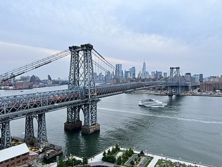
The Williamsburg Bridge is a suspension bridge across the East River in New York City, connecting the Lower East Side of Manhattan with the Williamsburg neighborhood of Brooklyn. Originally known as the East River Bridge, the Williamsburg Bridge was completed in 1903 and, at 7,308 feet (2,227 m) long, was the longest suspension bridge span in the world until 1924.

<span class="mw-page-title-main">Culver Depot</span> Former streetcar and railroad terminal in Brooklyn

Culver Depot, also called Culver Terminal or Culver Plaza, was a railroad and streetcar terminal in Coney Island, Brooklyn, New York City, United States, located on the northern side of Surf Avenue near West 5th Street. It was just north of the boardwalk, near the former Luna Park amusement complex, and across from the current New York Aquarium. Originally built by the Prospect Park and Coney Island Railroad for the Culver surface line, it later became a major terminal for the Brooklyn Rapid Transit Company (BRT).

<span class="mw-page-title-main">Delancey Street/Essex Street station</span> New York City Subway station complex in Manhattan

The Delancey Street/Essex Street station is a station complex shared by the BMT Nassau Street Line and the IND Sixth Avenue Lines of the New York City Subway, located at the intersection of Essex and Delancey Streets on the Lower East Side of Manhattan, just west of the Williamsburg Bridge. It is served by the:

The Culver Line, Gravesend Avenue Line, or McDonald Avenue Line was a surface public transit line in Brooklyn, New York City, United States, running along McDonald Avenue and built by the Prospect Park and Coney Island Railroad. Most of its main line has been essentially replaced by the IND Culver Line of the New York City Subway.

<span class="mw-page-title-main">B44 (New York City bus)</span> Bus route in Brooklyn, New York

The B44 is a public transit line in Brooklyn, New York City, running mostly along Nostrand Avenue, as well as northbound on Rogers Avenue or New York Avenue and Bedford Avenue, between Sheepshead Bay and Williamsburg. Originally a streetcar line, it is now the B44 bus route, operated by the New York City Transit Authority.

<span class="mw-page-title-main">Q59 (New York City bus)</span> Bus route in Queens and Brooklyn, New York

The Grand Street Line is a public transit line in Brooklyn and Queens, New York City, running mostly along the continuous Grand Street and Grand Avenue between Williamsburg, Brooklyn and Maspeth, Queens. It then continues down Queens Boulevard to the 63rd Drive–Rego Park station. Originally a streetcar line, it is now the Q59 bus route, operated by the New York City Transit Authority between Williamsburg and Rego Park, Queens.

<span class="mw-page-title-main">B15 (New York City bus)</span> Bus route in Brooklyn, New York

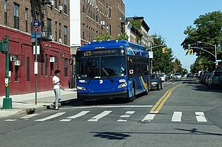
The Sumner Avenue Line and New Lots Avenue Line were two streetcar lines in Brooklyn, New York City, running mainly along Marcus Garvey Boulevard, East 98th Street, and New Lots Avenue between northern Bedford–Stuyvesant and New Lots. Originally streetcar lines, the two lines were combined as a bus route in 1947. That bus route became the present B15 Marcus Garvey Boulevard / New Lots Avenue service, operated by MTA New York City Bus' East New York Depot in East New York. The B15 continues east from New Lots to John F. Kennedy International Airport in Queens.

The Holy Cross Cemetery Line or Holy Cross Shuttle was a public transit line in Brooklyn, New York City, United States, running as a short branch of the Nostrand Avenue Line along Tilden Avenue east to Holy Cross Cemetery at Canarsie Lane. Originally a streetcar line, it was replaced by a bus route, which is no longer operated. The route operated out of Flatbush Depot.

<span class="mw-page-title-main">B61 and B62 buses</span> Bus routes in Brooklyn, New York

The Crosstown Line is a public transit line in Brooklyn, New York City, running along Van Brunt Street and Manhattan Avenue between Red Hook and Long Island City, Queens. Originally a streetcar line, it is now the B61 and the B62 bus routes. The northern section, the B62, is operated by MTA New York City Bus' Grand Avenue Depot in Maspeth, Queens, and the southern section is the B61, operated by MTA New York City Bus' Jackie Gleason Depot in Sunset Park. The entire route was a single line, the B61, until January 3, 2010; the B62 was previously a separate, parallel route between Downtown Brooklyn and Greenpoint, now part of the B43 route. The streetcar line, B61 and the original B62 previously operated from the now-closed Crosstown Depot in Greenpoint.

The Broadway Line was a public transit line in Brooklyn, New York City, United States along Broadway between Williamsburg and East New York. Originally a streetcar line, it later became a bus route, but no bus currently operates over the entire length of Broadway, with the BMT Jamaica Line above.

<span class="mw-page-title-main">B47 (New York City bus)</span> Bus route in Brooklyn, New York

The B47 is a surface transit line on Ralph Avenue in Brooklyn, New York City. Once a streetcar line, it is now part of the B47 bus route, operated by the New York City Transit Authority, Prior to 1995, it was the B78 route; the northern part of the route from St. Johns Place to Woodhull Hospital was part of the B40 line. The B47 was created as a result of a merger of the B40 and B78 on September 8, 2002.

<span class="mw-page-title-main">Q60 (New York City bus)</span> Bus route in Queens, New York

The Q60 bus route constitutes a public transit line running primarily along Queens Boulevard in Queens, New York City, extending from Jamaica, Queens, to Midtown Manhattan via Queens Boulevard and the Queensboro Bridge. It is city-operated under the MTA Bus Company brand of MTA Regional Bus Operations.

<span class="mw-page-title-main">Williamsburg Bridge Trolley Terminal</span> Former terminal in Manhattan, New York

The Williamsburg Bridge Trolley Terminal, also called the Essex Street Trolley Terminal or Delancey Street Trolley Terminal, was a trolley terminal located underground adjacent to the Essex Street subway station in the Lower East Side of Manhattan. Passenger trolley service operated through the terminal from 1908 until 1948 when trolley service over the Williamsburg Bridge ended. The station was constructed with balloon loops for turning around streetcars after they crossed over the Williamsburg Bridge to send them back to Brooklyn.

<span class="mw-page-title-main">Q58 (New York City bus)</span> Bus route in Queens, New York

The Q58 and Q58 Limited are bus routes that constitute a public transit line operating primarily in Queens, New York City, with its southern terminal on the border with Brooklyn. The Q58 is operated by the MTA New York City Transit Authority. Its precursor was a streetcar line that began operation in November 1899. and was known variously as the Flushing–Ridgewood Line, the Corona Avenue Line, and the Fresh Pond Road Line. The route became a bus line in 1949.

<span class="mw-page-title-main">Q72 (New York City bus)</span> Bus route in Queens, New York

The Q72 bus route constitutes a public transit route along Junction Boulevard and 94th Street in Queens, New York City. It operates between the Rego Park and East Elmhurst neighborhoods of Queens, and extends into LaGuardia Airport at the north end of the borough. It is city-operated under the MTA Bus Company brand of MTA Regional Bus Operations.

<span class="mw-page-title-main">B46 (New York City bus)</span> Bus route in Brooklyn, New York

The B46 bus route constitutes a public transit corridor in Brooklyn, New York City. The route runs primarily along Utica Avenue north from the Kings Plaza shopping center through Eastern Brooklyn, with continued service west along Broadway to the Williamsburg Bridge Plaza Bus Terminal. The corridor was originally served by a streetcar line, known as the Utica and Reid Avenues Line, Utica−Reid Line, Reid−Utica Line, Reid Avenue Line, or Utica Avenue Line until 1951, when the line was replaced by bus service. The bus route is operated by MTA Regional Bus Operations under the New York City Transit brand.

References

  1. 1 2 3 4 Linder, Bernard (April 2016). "Municipal Operations of Williamsburg Bridge Trolley Cars". New York Division Bulletin. 59 (4). Electric Railroaders' Association: 3–5. Retrieved October 21, 2016.
  2. 1 2 "Washington Plaza Is Formally Named: E.D. Residents Celebrate and Aldermanic Resolution Is Presented to Riegelmann". Brooklyn Daily Eagle . February 23, 1919. Retrieved October 21, 2016 via Newspapers.com.
  3. 1 2 Waite, Thomas L. (February 20, 1989). "About-Face for 'Valley Forge' Statue? Maybe". The New York Times . Retrieved July 3, 2015.
  4. 1 2 3 Report for the three and one-half years ending June 30, 1949. New York City Board of Transportation. 1949. hdl:2027/mdp.39015023094926.
  5. "Nostrand Ave. Trolley Makes Way for MTA New York City Transit Select Bus Service". mta.info . Metropolitan Transportation Authority. October 10, 2013. Archived from the original on July 3, 2015. Retrieved July 2, 2015.
  6. 1 2 3 "MTA Neighborhood Maps: neighborhood". Metropolitan Transportation Authority. 2018. Retrieved October 1, 2018.
  7. 1 2 "Williamsburg: More Than Just a Bridge: Community Crossroads". Brooklyn Daily Eagle . April 8, 1951. Retrieved July 22, 2015 via Newspapers.com.
  8. Brooklyn Daily Eagle (1923). "Washington Plaza". Brooklyn Public Library . Retrieved October 21, 2016.
  9. Branford Electric Railway Association (September 29, 2008). Brooklyn Streetcars. Arcadia Publishing. ISBN   978-1-4396-2045-8.
  10. 1 2 Stephen L. Meyers (2005). Manhattan's Lost Streetcars. Arcadia Publishing. pp. 58, 113. ISBN   978-0-7385-3884-6.
  11. Randall Gabrielan (November 1999). Brooklyn: New York in Vintage Postcards. Arcadia Publishing. pp. 85, 88. ISBN   978-0-7385-8786-8 . Retrieved October 21, 2016.
  12. 1 2 3 "CWA to Build Span Play Area: Site at Brooklyn End of Williamsburg Bridge Is to Be Converted". Brooklyn Daily Eagle . March 4, 1935. p. 1. Retrieved October 21, 2016 via Newspapers.com.
  13. "Extensive Improvements on the Williamsburg Bridge to be Ready Soon". Brooklyn Daily Eagle . January 9, 1908. p. 29. Retrieved October 21, 2016 via Newspapers.com.
  14. "Washington Plaza trolley station". New York Transit Museum. February 12, 1940. Retrieved October 21, 2016.
  15. "Metropolitan Street Railway - Fourth Avenue and Williamsburg Bridge Line". New York Transit Museum. 1905. Retrieved October 21, 2016.
  16. 1 2 3 "Busy Brooklyn". Brooklyn Daily Eagle . April 19, 1947. p. 3. Retrieved October 21, 2016 via Newspapers.com.
  17. 1 2 "LaGuardia Lauds Work of Moses After Bridge Tilf". Brooklyn Daily Eagle . July 2, 1935. p. 1. Retrieved October 21, 2016 via Newspapers.com.
  18. 1 2 "LaGuardia Lauds Work of Moses After Bridge Tilf". Brooklyn Daily Eagle . July 2, 1935. p. 2. Retrieved October 21, 2016 via Newspapers.com.
  19. Woodruff, Clinto Rogers (March 1905). "Notes on Municipal Government. The Activities of Civic Organizations for Municipal Improvement in the United States: A Symposium". Annals of the American Academy of Political and Social Science . 25 (City Life and Progress): 157–199. doi:10.1177/000271620502500211. S2CID   145085237.
  20. 1 2 "Buses Replacing Nostrand Ave. Trolleys; Horsecars Opened Flatbush Line in 1882". The New York Times . March 31, 1951. Retrieved July 2, 2015.
  21. "Rush On New Bridge: Sunday Crowds Necessitated Extra Cars. Most Patrons Traveled to Brownsville". Brooklyn Daily Eagle . November 7, 1904. p. 2. Retrieved January 19, 2016 via Newspapers.com.
  22. 1 2 "Through Service on Bridge to End" (PDF). The New York Times . November 22, 1923. Retrieved January 19, 2016.
  23. 1 2 "How The Cars Will Run Across The New Bridge". Brooklyn Daily Eagle . March 16, 1904. p. 1. Retrieved October 21, 2016 via Newspapers.com.
  24. 1 2 3 Kahn, Alan Paul (1973). The Tracks of New York Number 1: Metropolitan Street Railway 1907. Seymour Durst, Electric Railroaders' Association. Retrieved October 21, 2016.
  25. 1 2 "Restores Bridge Service: B.M.T. Abolishes 2-Cent Fare Today on Through Traffic" (PDF). The New York Times . February 15, 1931. Retrieved January 20, 2016.
  26. 1 2 "Municipal Operation of Williamsburg Bridge Trolley Cars Began 80 Years Ago". New York Division Bulletin. 46 (12). Electric Railroaders Association: 1, 4. December 2003. Retrieved January 21, 2016.
  27. "Whalen Builds Shed As Shelter Station". Brooklyn Standard Union . Fultonhistory.com. December 5, 1923. p. 14. Retrieved October 21, 2016.
  28. "Through Trolley Service on Bridge". Brooklyn Daily Eagle . February 15, 1931. p. 16. Retrieved January 19, 2016 via Newspapers.com.
  29. "Bans Trolley Lines on East River Span". The New York Times . January 21, 1932. Retrieved October 21, 2016.
  30. "Buses Take Over Williamsburg Run: Trolleys End Bridge Service-Old Underground Station No Longer in Use" (PDF). The New York Times . December 6, 1948. Retrieved October 21, 2016.
  31. "Williamsburg Bridge Trolleys Bow to Buses After 44 Years". Brooklyn Daily Eagle . December 5, 1948. p. 5. Retrieved October 21, 2016 via Newspapers.com.
  32. "City Buys Buses On No-Bid Basis: Emergency Approval Granted by Board-130 Vehicles to Cost $16,500" (PDF). The New York Times . November 8, 1947. pp. 1, 2. Retrieved October 21, 2016.
  33. "Public Notices". Brooklyn Daily Eagle . January 21, 1949. Retrieved July 22, 2015 via Newspapers.com.
  34. Rivera, Phelix (August 17, 1953). "Letters to the editor of the Eagle: Pleads for Fare Slash On Williamsburg Bridge". Brooklyn Daily Eagle . Retrieved July 22, 2015 via Newspapers.com.
  35. Meredith Hoffman (October 10, 2013). "Transit Hub by Williamsburg Bridge to Get New Restroom, Waiting Area". DNAinfo.com. Archived from the original on October 22, 2013. Retrieved November 1, 2013.
  36. Tanay Warerkar (October 11, 2013). "City unveils plans for bus plaza near Williamsburg Bridge". NY Daily News. Retrieved November 1, 2013.
  37. NYCDOT (June 19, 2012). "Nostrand Avenue / Rogers Avenue Select Bus Service" (PDF). nyc.gov . NYCDOT . Retrieved November 1, 2013.