Metropolitan Avenue/Lorimer Street station

Last updated

 Metropolitan Avenue/
 Lorimer Street
  NYCS-bull-trans-G-Std.svg NYCS-bull-trans-L-Std.svg
MTA NYC logo.svg New York City Subway station complex
Metropolitan Av entrance vc.jpg
Station statistics
AddressMetropolitan Avenue between Lorimer Street & Union Avenue
Brooklyn, NY 11211
Borough Brooklyn
Locale Williamsburg
Coordinates 40°42′46″N73°57′05″W / 40.712752°N 73.951464°W / 40.712752; -73.951464
DivisionBMT/IND [1] [2]
Line     BMT Canarsie Line
    IND Crosstown Line
Services    G   NYCS-SSI-alltimes.svg (all times)
   L   NYCS-SSI-alltimes.svg (all times)
TransitAiga bus trans.svg NYCT Bus: B24, B48, Q59
Levels2
Other information
OpenedJuly 1, 1948;75 years ago (1948-07-01)
Accessible Wheelchair symbol.svg ADA-accessible (Transfer passageway between IND Crosstown Line platforms and BMT Canarsie Line platforms is not accessible; use OMNY farecard readers for free accessible transfer)
Traffic
20223,409,157 [3] Increase2.svg 38.4%
Rank76 out of 423 [3]
Location
NYCS map blank.svg
Map pointer.svg
USA New York City location map.svg
Map pointer.svg
USA New York location map.svg
Map pointer.svg
Street map

Metropolitan Avenue/Lorimer Street station

Station service legend
SymbolDescription
NYCS-SSI-alltimes.svg Stops all times

The Metropolitan Avenue/Lorimer Street station is an underground New York City Subway station complex shared by the BMT Canarsie Line and the IND Crosstown Line. Located in the Williamsburg neighborhood of Brooklyn, the complex is served by the G and L trains at all times.

Contents

The BMT Canarsie Line platforms, which are named Lorimer Street, are located above the IND Crosstown Line platforms, which are named Metropolitan Avenue. The Canarsie Line station opened in 1924, and the Crosstown Line station opened in 1937. Free transfers between the stations started in 1948.

Station layout

GroundStreet levelEntrances/exits
Basement 1MezzanineFare control, station agent, MetroCard machines
Wheelchair symbol.svg Elevator to NYCS-bull-trans-L-Std.svg train at northwest corner of Lorimer Street and Metropolitan Avenue.
Basement 2 Side platform Wheelchair symbol.svg
Westbound NYCS-bull-trans-L-Std.svg toward Eighth Avenue (Bedford Avenue)
Eastbound NYCS-bull-trans-L-Std.svg toward Canarsie–Rockaway Parkway (Graham Avenue)
Side platform Wheelchair symbol.svg
MezzanineFare control, station agent, MetroCard machines, connection between platforms
Wheelchair symbol.svg Elevator to NYCS-bull-trans-G-Std.svg train at southeast corner of Union Avenue and Metropolitan Avenue.
Basement 3 Side platform Wheelchair symbol.svg
Northbound NYCS-bull-trans-G-Std.svg toward Court Square (Nassau Avenue)
Southbound NYCS-bull-trans-G-Std.svg toward Church Avenue (Broadway)
Side platform Wheelchair symbol.svg

The L-shaped passageway, located above the Crosstown Line at its northern end and below the Canarsie Line at its western end, also serves as the mezzanine for the Crosstown Line lower level. When viewed from the Crosstown Line mezzanine, the passageway splits up as the right half leads to a ramp for Canarsie-bound trains while the left half leads to a crossunder to Eighth Avenue-bound trains.

Originally, passengers who wished to transfer between the Canarsie and Crosstown lines had to pay a separate fare, because the Brooklyn–Manhattan Transit Corporation (operator of the Canarsie Line) and the Independent Subway System (the Crosstown Line's operator) were competing companies. On July 1, 1948, eight years after the three operators of New York's subways were unified into a single entity, the transfer passageway was reconfigured to be inside fare control, thus permitting free transfers between lines. [1] [4]

In 2019, the MTA announced that the station would become ADA-accessible as part of the agency's 2020–2024 Capital Program. [5] A contract for five elevators at the station (three for the Canarsie Line platforms and two for the Crosstown Line platforms) was awarded in December 2020. [6] A street-to-mezzanine elevator for the Crosstown Line platforms was added to the contract, resulting in a total of six elevators. All elevators opened on April 1, 2024. The transfer passageway between the Canarsie and Crosstown lines is not accessible, so an out-of-system transfer for disabled riders is provided using OMNY farecard readers. The passageway to the Manhattan-bound Canarsie Line platform has stairs, and the passageway to the Canarsie-bound platform has a ramp that is not accessible. [7]

A precinct of the New York City Transit Police is also located on the Crosstown Line mezzanine.

Artwork

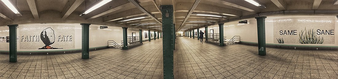
The artwork in the transfer passageway and the Crosstown Line mezzanine is called Signs of Life, [8] designed by Jackie Chang in 2000. [9] [10] Signs of Life is made of ceramic tiles of glass and consists of numerous juxtaposed words and icons. [9] The words in the artwork are compound words that have been taken apart, such as "useless" or "mankind". [8] In designing the artwork, Chang intended for the pieces to be "challenging" and cryptic. [9] Signs of Life originally consisted of six mosaics, but two additional mosaics were added when the station's elevators opened in 2024. [7]

The Lorimer Street station's fare control area also contains the artwork Personal Choice #5, designed by Chloë Bass and completed in 2024. The artwork is split up into three sections and depicts human connections and touch. Each portion of Personal Choice #5 is accompanied by a text caption, which is overlaid atop the artwork. [7]

Metropolitan Av panorama vc.jpg
Panoramic view of the mezzanine

Exits

The main entrances at the corner of Metropolitan and Union Avenues lead to the transfer corridor between the lines. [11] The high entry-exit turnstiles in the transfer corridor would be replaced with waist-high "low turnstiles" to accommodate increased passenger flow. [12]

Each platform has a second set of entrances. The BMT platforms have a second set to the eastern corners of Lorimer Street and Metropolitan Avenue at their east ends. The IND platforms have one stair leading to the northwestern corner of Union Avenue and Hope Street and another leading to the northeastern corner of Union Avenue and Powers Street. The exits to Powers and Hope Streets were previously closed in 2000 due to safety concerns, blocked by metal street grates, and used as emergency exits. [12] They were reopened on February 28, 2019 to accommodate the increased volume of passengers transferring between the Crosstown and Canarsie Line stations due to the 14th Street Tunnel shutdown. [13] Originally, only one of these exits was planned to be reopened. [14]

Despite the IND station's name on tiling, there is no longer an open exit to Grand Street. A passage beyond the Hope and Powers Streets exits leads to two more exits that led to both northern corners of Grand Street and Union Avenue. [15] [16] [17] These exits were also closed in 2000 due to safety concerns. While the exit to the northeastern corner is also blocked by a metal sheet grate, the exit to the northwestern corner has been sealed and is inaccessible from street level. [15] [18] The exits to Grand Street were open until the section of the mezzanine that had the exits to Hope Street and Powers Street was closed; this is corroborated by photos of this portion of the mezzanine during its closure, which had signage directing to Grand Street intact, as well as MTA documents outlining the closure of the whole area. [19]

The BMT station previously had two closed exits; they led to the western corners of Lorimer Street and Metropolitan Avenue. They were also closed in 2000 and were repurposed into emergency exits. As part of the ADA accessibility improvements, the exit to the southwestern corner was reopened while the exit to the northwestern corner was demolished to make room for a street elevator at that corner.

The transfer mezzanine also features one closed staircase to the southeastern corner of Metropolitan Avenue and Union Avenue. The staircase was also closed in 2000, but has been completely sealed from both the street level and the mezzanine level.

BMT Canarsie Line platforms

 Lorimer Street
  NYCS-bull-trans-L-Std.svg
MTA NYC logo.svg New York City Subway station (rapid transit)
Lorimer Street BMT IMG 9155.JPG
Northbound platform
Station statistics
Division B (BMT) [2]
Line     BMT Canarsie Line
Services    L   NYCS-SSI-alltimes.svg (all times)
StructureUnderground
Platforms2 side platforms
Tracks2
Other information
OpenedJune 30, 1924;99 years ago (1924-06-30)
Accessible Wheelchair symbol.svg ADA-accessible (Use OMNY farecard readers to transfer to IND Crosstown Line platforms)
Opposite-
direction
transfer
Yes
Services
Preceding station MTA NYC logo.svg New York City Subway Following station
Bedford Avenue NYCS-bull-trans-L-Std.svg Graham Avenue
Track layout

BSicon MFADEg.svg
BSicon uvSTR.svg
BSicon uvSTRfg.svg
BSicon numN090.svg
BSicon BSl.svg
BSicon uvSTR.svg
BSicon BSr.svg
BSicon BSl.svg
BSicon uvSTR.svg
BSicon BSr.svg
BSicon BSl.svg
BSicon uvSTR.svg
BSicon BSr.svg
BSicon uvSTRfg.svg
BSicon MFADEf.svg
BSicon uvSTR.svg
Station service legend
SymbolDescription
NYCS-SSI-alltimes.svg Stops all times

The Lorimer Street station (announced as Metropolitan Avenue-Lorimer Street station) on the BMT Canarsie Line has two tracks and two side platforms. It opened on June 30, 1924, as part of the initial segment of the underground Canarsie Line, a product of the Dual Contracts, stretching from Sixth Avenue in Manhattan to Montrose Avenue. [20] [21] The L stops at the station at all times. [22] The station is between Bedford Avenue to the west and Graham Avenue to the east. [23]

The Lorimer Street entry point has a mezzanine above the station. There is also another entrance at Union Avenue that leads directly to the Manhattan-bound platform. The transfer to the Crosstown Line is toward the Union Avenue (western; railroad northern) end of the station, where passageways descend from each platform to the Union Avenue mezzanine.

IND Crosstown Line platforms

 Metropolitan Avenue
  NYCS-bull-trans-G-Std.svg
MTA NYC logo.svg New York City Subway station (rapid transit)
IND Crosstown Metropolitan Avenue Northbound Platform.jpg
View of northbound platform
Station statistics
Division B (IND) [2]
Line     IND Crosstown Line
Services    G   NYCS-SSI-alltimes.svg (all times)
StructureUnderground
Platforms2 side platforms
Tracks2
Other information
OpenedJuly 1, 1937;86 years ago (1937-07-01) [24]
Accessible Wheelchair symbol.svg ADA-accessible (Use OMNY farecard readers to transfer to BMT Canarsie Line platforms)
Opposite-
direction
transfer
Yes
Former/other namesMetropolitan Avenue–Grand Street
Services
Preceding station MTA NYC logo.svg New York City Subway Following station
Nassau Avenue
toward Court Square
NYCS-bull-trans-G-Std.svg Broadway
Track layout

BSicon MFADEg.svg
BSicon uvSTR.svg
BSicon uvSTRfg.svg
BSicon numN000.svg
BSicon BSl.svg
BSicon uvSTR.svg
BSicon BSr.svg
BSicon BSl.svg
BSicon uvSTR.svg
BSicon BSr.svg
BSicon BSl.svg
BSicon uvSTR.svg
BSicon BSr.svg
BSicon BSl.svg
BSicon uvSTR.svg
BSicon BSr.svg
BSicon uvSTRfg.svg
BSicon MFADEf.svg
BSicon uvSTR.svg
Station service legend
SymbolDescription
NYCS-SSI-alltimes.svg Stops all times

The Metropolitan Avenue station (also announced as Metropolitan Avenue-Lorimer Street station) on the IND Crosstown Line opened on July 1, 1937 as part of the extension of the Crosstown Line from Nassau Avenue to Hoyt-Schermerhorn Streets. [24] The station also has two tracks and two side platforms. [25] The G stops at the station at all times. [26] The station is between Nassau Avenue to the north and Broadway to the south. [23]

The station has green tiles. The tiles were part of a color-coded tile system used throughout the IND. [27] The tile colors were designed to facilitate navigation for travelers going away from Lower Manhattan. Because the Crosstown Line does not merge into a line that enters Manhattan at either end, all stations on the line had green tiles. [28] [29] Station tile signage retains the original name of the station: Metropolitan Avenue–Grand Street. Directional tile captions mimicking the style of original IND captions indicate "To Street and Transfer;" [30] the tile captions replaced original captions pointing to Metropolitan Avenue at the north end and Grand Street at the south end. [31] Two staircases from the north end of either platform lead to the mezzanine and transfer passageway to the BMT Canarsie Line. [25] [32]

The mezzanine is full-length, but has been reduced in size. A central portion was closed in the late 1990s and is now occupied by a police facility, employee space, and offices. [30] The south portion was also previously closed and used as storage space, but was reopened on February 28, 2019 in preparation for the 14th Street Tunnel shutdown in April 2019. A previously removed staircase between the southbound platform and the mezzanine was also built. [33]

Related Research Articles

<span class="mw-page-title-main">Times Square–42nd Street station</span> New York City Subway station complex in Manhattan

The Times Square–42nd Street station is a major New York City Subway station complex located under Times Square, at the intersection of 42nd Street, Seventh Avenue, and Broadway, in Midtown Manhattan. The complex allows free transfers between the IRT 42nd Street Shuttle, the BMT Broadway Line, the IRT Broadway–Seventh Avenue Line and the IRT Flushing Line, as well as to the IND Eighth Avenue Line a block west at 42nd Street–Port Authority Bus Terminal. The complex is served by the 1, 2, 3, 7, N and Q trains at all times, the W train during weekdays; the R and 42nd Street Shuttle (S) trains at all times except late nights; and <7> trains during rush hours in the peak direction. A free passageway from the shuttle platform to the 42nd Street–Bryant Park/Fifth Avenue station, served by the 7, <7>​​, B, ​D, ​F, <F>, and ​M trains, is open during the day from 6 a.m. to 12 a.m.

<span class="mw-page-title-main">34th Street–Herald Square station</span> New York City Subway station complex in Manhattan

The 34th Street–Herald Square station is an underground station complex on the BMT Broadway Line and the IND Sixth Avenue Line of the New York City Subway. It is located at Herald Square in Midtown Manhattan where 34th Street, Broadway and Sixth Avenue intersect, and is served by the D, F, N, and Q trains at all times; the R train at all times except late nights; the B, M, and W trains on weekdays; and the <F> train during rush hours in the peak direction.

<span class="mw-page-title-main">Lafayette Avenue station (IND Fulton Street Line)</span> New York City Subway station in Brooklyn

The Lafayette Avenue station is a local station on the IND Fulton Street Line of the New York City Subway. Located under Lafayette Avenue and Fulton Street in Brooklyn, it is served by the C train at all times except nights, when the A train takes over service.

<span class="mw-page-title-main">Fulton Street station (IND Crosstown Line)</span> New York City Subway station in Brooklyn

The Fulton Street station is a station on the IND Crosstown Line of the New York City Subway, located on Lafayette Avenue between South Portland Avenue and Fulton Street in Brooklyn. It is served by the G train at all times.

<span class="mw-page-title-main">Seventh Avenue station (IND Culver Line)</span> New York City Subway station in Brooklyn

The Seventh Avenue station is an express station on the IND Culver Line of the New York City Subway, located at Seventh Avenue and Ninth Street in the Park Slope neighborhood of Brooklyn. It is served by the F and G trains at all times, and by the <F> train during rush hours in the peak direction.

<span class="mw-page-title-main">15th Street–Prospect Park station</span> New York City Subway station in Brooklyn

The 15th Street–Prospect Park station is a local station on the IND Culver Line of the New York City Subway. Located at 15th Street east of Prospect Park West in the Windsor Terrace and Park Slope neighborhoods in Brooklyn, it is served by the F and G trains at all times.

<span class="mw-page-title-main">East Broadway station</span> New York City Subway station in Manhattan

The East Broadway station is a station on the IND Sixth Avenue Line of the New York City Subway. Located at East Broadway and Rutgers Street in the Lower East Side, it is served by the F train at all times and the <F> train during rush hours in the peak direction.

<span class="mw-page-title-main">Lexington Avenue–63rd Street station</span> New York City Subway station in Manhattan

The Lexington Avenue–63rd Street station is a New York City Subway station in Lenox Hill, Manhattan, shared by the IND and BMT 63rd Street Lines. Located at the intersection of Lexington Avenue and 63rd Street, it is served by the F and Q trains at all times; <F> trains during rush hours in the peak direction; limited rush hour N trains in the southbound direction only; and one A.M. rush hour R train in the northbound direction only.

<span class="mw-page-title-main">Lorimer Street station (BMT Jamaica Line)</span> New York City Subway station in Brooklyn

The Lorimer Street station is a local station on the BMT Jamaica Line of the New York City Subway. Located at the intersection of Lorimer Street and Broadway in Brooklyn, it is served by the J train at all times except weekdays in the peak direction and the M train at all times except late nights. The Z train skips this station when it operates.

<span class="mw-page-title-main">Broadway Junction station</span> New York City Subway station complex in Brooklyn

The Broadway Junction station is a New York City Subway station complex shared by the elevated BMT Canarsie Line and BMT Jamaica Line, and the underground IND Fulton Street Line. It was also served by trains of the Fulton Street Elevated until that line closed in 1956. It is located roughly at the intersection of Broadway, Fulton Street and Van Sinderen Avenue at the border of Bedford–Stuyvesant and East New York, Brooklyn. The complex is served by the A, J, and L trains at all times; the C train at all times except late nights; and the Z train during rush hours in the peak direction only.

<span class="mw-page-title-main">Court Square–23rd Street station</span> New York City Subway station complex in Queens

The Court Square–23rd Street station is a New York City Subway station complex on the IND Crosstown Line, the IRT Flushing Line and the IND Queens Boulevard Line. The complex is located in the vicinity of One Court Square in Hunters Point and Long Island City, Queens, and is served by the 7, E, and G trains at all times; the M train on weekdays; and the <7> express train during weekdays in the peak direction.

<span class="mw-page-title-main">Greenpoint Avenue station</span> New York City Subway station in Brooklyn

The Greenpoint Avenue station is a station on the IND Crosstown Line of the New York City Subway. Located at the intersection of Greenpoint and Manhattan Avenues in Greenpoint, Brooklyn, it is served by the G train at all times.

<span class="mw-page-title-main">Nassau Avenue station</span> New York City Subway station in Brooklyn

The Nassau Avenue station is a station on the IND Crosstown Line of the New York City Subway. Located at the intersection of Manhattan and Nassau Avenues in Greenpoint, Brooklyn, it is served by the G train at all times.

<span class="mw-page-title-main">Broadway station (IND Crosstown Line)</span> New York City Subway station in Brooklyn

The Broadway station is a station on the IND Crosstown Line of the New York City Subway. Located at the intersection of Broadway and Union Avenue in Williamsburg, Brooklyn, it is served at all times by the G train.

<span class="mw-page-title-main">Bedford–Nostrand Avenues station</span> New York City Subway station in Brooklyn

The Bedford–Nostrand Avenues station is a station on the IND Crosstown Line of the New York City Subway. Located at Lafayette Avenue between Bedford and Nostrand Avenues in Bedford–Stuyvesant, Brooklyn, it is served by the G train at all times.

<span class="mw-page-title-main">Clinton–Washington Avenues station (IND Crosstown Line)</span> New York City Subway station in Brooklyn

The Clinton–Washington Avenues station is a station on the IND Crosstown Line of the New York City Subway. Located at Lafayette Avenue between Clinton and Washington Avenues in Clinton Hill, Brooklyn, it is served by the G train at all times.

<span class="mw-page-title-main">14th Street/Eighth Avenue station</span> New York City Subway station complex in Manhattan

The 14th Street/Eighth Avenue station is an underground New York City Subway station complex shared by the IND Eighth Avenue Line and the BMT Canarsie Line. Located at Eighth Avenue and 14th Street in Manhattan, the station is served by the A, E and L trains at all times and the C train at all times except late nights.

<span class="mw-page-title-main">Jay Street–MetroTech station</span> New York City Subway station complex in Brooklyn

The Jay Street–MetroTech station is a New York City Subway station complex on the IND Fulton Street, IND Culver, and BMT Fourth Avenue lines. The complex is located in the vicinity of MetroTech Center in Downtown Brooklyn. It is served by the A, F, and R trains at all times; the C train at all times except late nights; the N train during late nights only; and a few rush-hour W and <F> trains in the peak direction.

<span class="mw-page-title-main">14th Street/Sixth Avenue station</span> New York City Subway station complex in Manhattan

The 14th Street/Sixth Avenue station is an underground New York City Subway station complex in Greenwich Village and Chelsea, Manhattan, on the IRT Broadway–Seventh Avenue Line, the BMT Canarsie Line and the IND Sixth Avenue Line. It is located on 14th Street between Sixth Avenue and Seventh Avenue. It is served by the 1, 2, F, and L trains at all times, by the 3 train at all times except late nights, the M train during weekdays, and the <F> train during rush hours in the peak direction.

<span class="mw-page-title-main">Chambers Street–World Trade Center/Park Place/Cortlandt Street station</span> New York City Subway station complex in Manhattan

The Chambers Street–World Trade Center/Park Place/Cortlandt Street station is a New York City Subway station complex on the IND Eighth Avenue Line, IRT Broadway–Seventh Avenue Line, and BMT Broadway Line. Located on Church Street between Chambers and Cortlandt Streets in Lower Manhattan, it is served by the 2, A and E trains at all times; W train on weekdays; 3, C and R trains at all times except late nights; and N train during late nights.

References

  1. 1 2 "Transfer Points Under Higher Fare: Board of Transportation Lists Stations and Intersections for Combined Rides". New York Times . June 30, 1948. p. 19. Retrieved May 5, 2010.
  2. 1 2 3 "Glossary". Second Avenue Subway Supplemental Draft Environmental Impact Statement (SDEIS) (PDF). Vol. 1. Metropolitan Transportation Authority. March 4, 2003. pp. 1–2. Archived from the original (PDF) on February 26, 2021. Retrieved January 1, 2021.
  3. 1 2 "Annual Subway Ridership (2017–2022)". Metropolitan Transportation Authority. 2022. Retrieved November 8, 2023.
  4. Sparberg, Andrew J. (October 1, 2014). From a Nickel to a Token: The Journey from Board of Transportation to MTA. Fordham University Press. ISBN   9780823261901.
  5. "Press Release - MTA Headquarters - MTA Announces 20 Additional Subway Stations to Receive Accessibility Improvements Under Proposed 2020-2024 Capital Plan". MTA. December 19, 2019. Archived from the original on March 22, 2020. Retrieved December 25, 2019.
  6. "MTA Announces Accessibility Projects at Eight Stations Throughout the Five Boroughs" (Press release). Metropolitan Transportation Authority. December 16, 2020. Archived from the original on May 26, 2021. Retrieved May 26, 2021.
  7. 1 2 3 "MTA Celebrates Accessibility Upgrades at Metropolitan Av-Lorimer St G and L Stations". MTA. April 1, 2024. Retrieved April 2, 2024.
  8. 1 2 Michalos, Michelle (August 28, 2013). "Art in Your Pocket: Artist Reed Seifer's optimism MetroCard". THIRTEEN - New York Public Media. Retrieved April 2, 2024.
  9. 1 2 3 "Signs of Life". MTA. Retrieved April 2, 2024.
  10. "Top ten: MTA subway art". Time Out New York. April 12, 2012. Retrieved April 2, 2024.
  11. "MTA Neighborhood Maps: Williamsburg & Bedford Stuyvesant" (PDF). mta.info . Metropolitan Transportation Authority. 2015. Retrieved July 20, 2016.
  12. 1 2 New York City Transit Authority (July 2018). "MTA New York City Transit Canarsie Tunnel Project Supplemental Environmental Assessment and Section 4(f) Review: Final Report" (PDF). mta.info. Metropolitan Transportation Authority. pp. 15–16. Retrieved July 27, 2018.
  13. Hanrahan, Laura (March 1, 2019). "MTA Reopens 2 Station Entrances at Metropolitan Av/ Lorimer St Station". Greenpoint Post. Archived from the original on March 1, 2019. Retrieved March 1, 2019.
  14. Kabak, Benjamin (December 13, 2017). "First Look: DOT, MTA present initial plans for L train shutdown". Second Ave. Sagas. Retrieved December 16, 2017.
  15. 1 2 Hogan, Gwynne (February 29, 2016). "Open Shuttered Subway Entrances Before L Train Shutdown, Advocates Urge". DNAinfo.com . Williamsburg, Brooklyn. Archived from the original on August 21, 2016. Retrieved July 5, 2016.
  16. "Closed subway entrances". WNYC (AM). October 31, 2015. Retrieved July 4, 2016.
  17. "2012-11-10 22.15.52". November 10, 2012.
  18. Harshbarger, Rebecca (November 1, 2015). "NYC subway station entrances closed despite ridership spike: over one in four". AM New York . Retrieved July 5, 2016.
  19. Kabak, Benjamin (January 24, 2013). "Inside Metropolitan Avenue's shuttered G passageway". Second Ave. Sagas. Retrieved March 30, 2019.
  20. "Subway Tunnel Through". The New York Times. August 8, 1919. Retrieved February 28, 2010.
  21. "Celebrate Opening of Subway Link". The New York Times. July 1, 1924. Retrieved February 13, 2010.
  22. "LSubway Timetable, Effective December 4, 2022". Metropolitan Transportation Authority . Retrieved August 26, 2023.
  23. 1 2 "Subway Map" (PDF). Metropolitan Transportation Authority. September 2021. Retrieved September 17, 2021.
  24. 1 2 "New Crosstown Subway Line Is Opened". Brooklyn Daily Eagle. July 1, 1937. Retrieved December 24, 2015.
  25. 1 2 "Review of the G Line: Appendices" (PDF). Metropolitan Transportation Authority. July 10, 2013. Retrieved October 28, 2015.
  26. "GSubway Timetable, Effective July 2, 2023". Metropolitan Transportation Authority . Retrieved August 26, 2023.
  27. "Tile Colors a Guide in the New Subway; Decoration Scheme Changes at Each Express Stop to Tell Riders Where They Are". The New York Times. August 22, 1932. ISSN   0362-4331. Archived from the original on July 1, 2022. Retrieved July 1, 2022.
  28. Carlson, Jen (February 18, 2016). "Map: These Color Tiles In The Subway System Used To Mean Something". Gothamist. Archived from the original on May 10, 2023. Retrieved May 10, 2023.
  29. Gleason, Will (February 18, 2016). "The hidden meaning behind the New York subway's colored tiles". Time Out New York. Archived from the original on May 10, 2023. Retrieved May 10, 2023.
  30. 1 2 Kabak, Benjamin (January 24, 2013). "Inside Metropolitan Avenue's shuttered G passageway". Second Avenue Sagas. Retrieved July 5, 2016.
  31. "Showing Image 56257".
  32. "Review of the G Line" (PDF). mta.info . Metropolitan Transportation Authority. July 10, 2013. Retrieved August 2, 2015.
  33. "Station Capacity Enhancements at Metropolitan Avenue". web.mta.info. Metropolitan Transportation Authority. December 31, 2017. Retrieved February 18, 2018.

Google Maps Street View: