West Broadway

Last updated
Template:Attached KML/West Broadway
KML is from Wikidata
West Broadway
LaGuardia Place
W Bwy becomes 2 Way crossing Grand St jeh.jpg
Looking north towards Grand Street
West Broadway
Owner City of New York
Maintained by NYCDOT
Length1.4 mi (2.3 km) [1]
Postal code10017, 10013, 10012
Nearest metro station Chambers Street NYCS-bull-trans-1-Std.svg NYCS-bull-trans-2-Std.svg NYCS-bull-trans-3-Std.svg
Franklin Street NYCS-bull-trans-1-Std.svg NYCS-bull-trans-2-Std.svg
Canal Street NYCS-bull-trans-A-Std.svg NYCS-bull-trans-C-Std.svg NYCS-bull-trans-E-Std.svg
South end Vesey Street in Financial District
North end Washington Square South in Greenwich Village
East Church Street (south of Canal)
Wooster Street (north of Canal)
West Greenwich Street (south of Chambers)
Hudson Street (Chambers to Leonard)
Varick Street (Leonard to Canal)
Thompson Street (north of Canal)

West Broadway is a north-south street in the New York City borough of Manhattan, separated into two parts by Tribeca Park. The northern part begins at Tribeca Park, near the intersection of Avenue of the Americas (Sixth Avenue), Walker Street and Beach Street in Tribeca. It runs northbound as a one-way street past Canal Street and becomes two-way at the intersection with Grand Street one block farther north. West Broadway then operates as a main north-south thoroughfare through SoHo until its northern end at Houston Street, on the border between SoHo and Greenwich Village. North of Houston Street, it is designated as LaGuardia Place, which continues until Washington Square South.

Contents

The southern part of West Broadway runs southbound from Tribeca Park [note 1] through the TriBeCa neighborhood, ending at Park Place. Prior to the September 11, 2001 attacks, West Broadway continued southward into the World Trade Center site, ending at Vesey Street. It was once considered "Rotten Row". [2]

History

West Broadway was once two streets: Chapel Street below Canal Street, and Laurens Street above it.

In the early 1750s, Trinity Church laid down a street grid on its property, known as King's Farm, between the Hudson River and Broadway in lower Manhattan. About the same time, Trinity founded King's College, now Columbia University, and donated a plot of land bordered by Barclay, Murray, and Church Streets for its campus, [3] to which the school moved in 1760. [4] According to a 1755 map, "Chappel Street" was part of this grid, running from Barkly (Barclay) to just past Warrens (Warren) Street and ending at the palisade which protected the north end of the city. [5] In the 1760s, Trinity Church ceded its streets between Fulton and Reade Streets to the city and Anthony Rutgers' heirs, owners of the land north of Reade Street, mapped their property into streets and lots. In the 1790s, Chapel Street was graded and paved from Murray to Reade Streets and extended to Leonard Street. [6]

In 1831, the New York City Common Council renamed the two blocks of Chapel Street between Barclay and Murray Streets "College Place". [7] A decade later Chapel Street was renamed "West Broadway" with the same purpose as that behind the renaming of East Broadway, to reduce the traffic congestion on Broadway itself, [8] but both names were used for over twenty more years. An 1835 map calls Chapel Street "West Broadway" [9] but an 1850 map calls it "Chapel Street". [10] [note 2] Around 1850, the two blocks from Murray to Chambers Street were renamed to be part of College Place. [11]

Origin of Laurens Street West Bayard Farm.jpg
Origin of Laurens Street

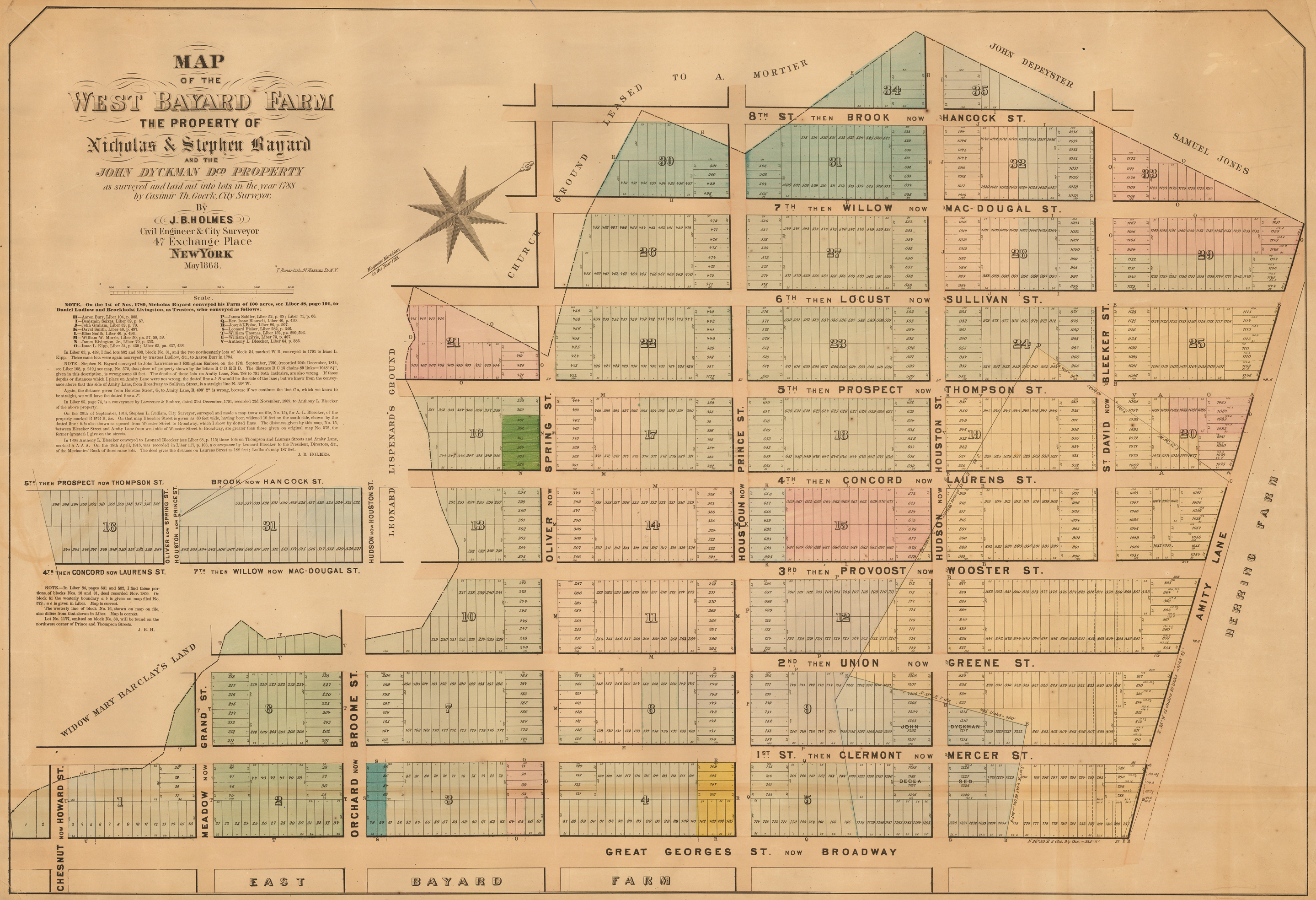
Laurens Street belonged to a different grid. In 1788, the Bayard family, dividing their farm into blocks and lots for sale, laid down eight streets parallel to Broadway, numbered from east to west, plus seven cross streets. A few years later, the numbered streets were named, and by the turn of the century they were renamed again for Revolutionary War officers, including Henry Laurens (see map). [12] [13] By the 1830s, the neighborhood was a red-light district nicknamed "Rotten Row", [14] and by the 1860s it was beset by poverty, filth, and violent crime. An 1860 proposal to widen Laurens Street and extend it north one block to Washington Square Park [15] was carried out in 1869 and 1870. In addition, a roadway was built to connect West Broadway to Fifth Avenue, introducing carriage traffic into Washington Square Park, and Laurens Street was officially renamed South Fifth Avenue in an attempt to improve its image. [16] [17]

The 1860 proposal to widen Laurens Street had accompanied a proposal to widen College Place and extend it southward to Greenwich Street. [18] [note 3] It was finally carried out in 1895, [19] when Laurens Street and South Fifth Avenue were both made part of West Broadway. [20]

LaGuardia Place

In 1967 the section of the street north of Houston Street was renamed "LaGuardia Place", after former mayor Fiorello La Guardia. [21] It features LaGuardia Gardens, between West 3rd and Bleecker Streets, which includes a commissioned statue of the "Little Flower", as La Guardia was nicknamed. Sculpted by Neil Estern, with a pedestal designed by architect Ruth Shapiro, the bronze statue was dedicated in 1994, and was commissioned and donated to the city by the Friends of LaGuardia Place. [22] The sculpture was commissioned as part of a project to beautify and revitalize that section of the street, whose buildings had been torn down many years before by Robert Moses to be part of the Fifth Avenue South connector to his never-built Lower Manhattan Expressway. [23]

Transportation

Current

The southbound M20 bus of the New York City Bus system runs on West Broadway from the five-way intersection with Varick Street and Leonard Street south to Chambers Street. [24] The Franklin Street and Chambers Street stations of the IRT Broadway–Seventh Avenue Line ( 1 , 2 , and 3 trains) are located on West Broadway. [25]

Former

The Sixth Avenue Elevated, formally the Metropolitan Elevated Railway, opened on June 5, 1878. It ran above College Place, West Broadway, and South Fifth Avenue from Murray Street, where it turned from Church Street, to Amity (West 3rd) Street, where it turned to Sixth Avenue. [26] The Sixth Avenue El was abandoned on December 4, 1938 and razed in 1939, being replaced by the underground IND Eighth Avenue Line. [27]

Related Research Articles

<span class="mw-page-title-main">Broadway (Manhattan)</span> Avenue in New York

Broadway is a road in the U.S. state of New York. Broadway runs from State Street at Bowling Green for 13 mi (21 km) through the borough of Manhattan and 2 mi (3.2 km) through the Bronx, exiting north from New York City to run an additional 18 mi (29 km) through the Westchester County municipalities of Yonkers, Hastings-On-Hudson, Dobbs Ferry, Irvington, and Tarrytown, and terminating north of Sleepy Hollow.

<span class="mw-page-title-main">Houston Street</span> Street in Manhattan, New York

Houston Street is a major east–west thoroughfare in Lower Manhattan in New York City. It runs the full width of the island of Manhattan, from FDR Drive along the East River in the east to the West Side Highway along the Hudson River in the west. The street is divided into west and east sections by Broadway.

<span class="mw-page-title-main">Upper West Side</span> Neighborhood of Manhattan in New York City

The Upper West Side (UWS) is a neighborhood in the borough of Manhattan in New York City. It is bounded by Central Park on the east, the Hudson River on the west, West 59th Street to the south, and West 110th Street to the north. The Upper West Side is adjacent to the neighborhoods of Hell's Kitchen to the south, Columbus Circle to the southeast, and Morningside Heights to the north.

<span class="mw-page-title-main">Tribeca</span> Neighborhood of Manhattan, New York City

Tribeca, originally written as TriBeCa, is a neighborhood in Lower Manhattan in New York City. Its name is a syllabic abbreviation of "Triangle Below Canal Street". The "triangle" is bounded by Canal Street, West Street, Broadway, and Chambers Street. By the 2010s, a common marketing tactic was to extend Tribeca's southern boundary to either Vesey or Murray Streets to increase the appeal of property listings.

<span class="mw-page-title-main">Sixth Avenue</span> North/south avenue in Manhattan, New York City, also known as Avenue of the Americas

Sixth Avenue – also known as Avenue of the Americas, although this name is seldom used by New Yorkers – is a major thoroughfare in New York City's borough of Manhattan, on which traffic runs northbound, or "uptown". It is commercial for much of its length.

<span class="mw-page-title-main">Fieldston, Bronx</span> Neighborhood of the Bronx in New York City

Fieldston is a privately owned affluent neighborhood in the Riverdale section of the northwestern part of the New York City borough of the Bronx. It is bounded by Manhattan College Parkway to the south, Henry Hudson Parkway to the west, 250th Street to the north, and Broadway to the east. It is noted for its rural atmosphere, large houses and abundance of trees. The majority of the neighborhood is included in the Fieldston Historic District, designated by the New York City Landmarks Preservation Commission in 2006.

<span class="mw-page-title-main">Chambers Street station (IRT Broadway–Seventh Avenue Line)</span> New York City Subway station in Manhattan

The Chambers Street station is an express station on the IRT Broadway–Seventh Avenue Line of the New York City Subway, located at the intersection of Chambers Street and West Broadway in Lower Manhattan. It is served by the 1 and 2 trains at all times, and by the 3 train at all times except late nights.

<span class="mw-page-title-main">4th Street (Manhattan)</span> Northwest-southeast street in Manhattan, New York

4th Street is a street in Lower Manhattan, New York City. It starts at Avenue D as East 4th Street and continues to Broadway, where it becomes West 4th Street. It continues west until the Avenue of the Americas, where West 4th Street turns north and confusingly intersects with West 10th, 11th, 12th, and 13th Streets in Greenwich Village. Most of the street has the same 40-foot (12 m) width between curbstones as others in the prevailing street grid, striped as two curbside lanes and one traffic lane, with one-way traffic eastbound. The portion from Seventh to Eighth Avenues is westbound and is approximately 35 feet (11 m) wide, a legacy of the original Greenwich Village street grid. The section of four short blocks from MacDougal Street to University Place which forms the southern border of Washington Square Park is called Washington Square South.

<span class="mw-page-title-main">Washington Square Village</span> Residential skyscrapers in Manhattan, New York

Washington Square Village (WSV) is an apartment complex in a superblock in the Greenwich Village neighborhood of Manhattan, New York City. WSV was developed by Paul Tishman and Morton S. Wolf. To design the housing complex, the developer selected architects S. J. Kessler and Sons, with Paul Lester Weiner as consultant for site planning and design; landscape architects were Sasaki, Walker & Associates.

The Sixth Avenue Line was a public transit line in Manhattan, New York City, running mostly along Sixth Avenue from Lower Manhattan to Central Park. Originally a streetcar line and later a bus route, it has been absorbed into the M5 bus route, which replaced the Broadway Line, as its northbound direction.

<span class="mw-page-title-main">M10 and M20 buses</span> Bus routes in Manhattan, New York

The Eighth Avenue Line is a public transit line in Manhattan, New York City, running mostly along Eighth Avenue from Lower Manhattan to Harlem. Originally a streetcar line, it is now the M10 bus route and the M20 bus route, operated by the New York City Transit Authority. The M10 bus now only runs north of 57th Street, and the M20 runs south of 66th Street. The whole line was a single route, the M10, until 2000 when the M20 was created.

<span class="mw-page-title-main">M11 (New York City bus)</span> Bus route in Manhattan, New York

The Ninth and Tenth Avenues Line or Ninth Avenue Line is a surface transit line in the New York City borough of Manhattan, running mostly along Ninth Avenue and Amsterdam Avenue from Lower Manhattan to Manhattanville. Originally a streetcar line operated by the Manhattan and Bronx Surface Transit Operating Authority, it is now the M11 bus route operated by the New York City Transit Authority.

<span class="mw-page-title-main">Chambers Street (Manhattan)</span> Street in Manhattan, New York

Chambers Street is a two-way street in the New York City borough of Manhattan. It runs from River Terrace, Battery Park City in the west, past PS 234, The Borough of Manhattan Community College, and Stuyvesant High School, to the Manhattan Municipal Building at 1 Centre Street in the east. Between Broadway and Centre Street, Chambers Street forms the northern boundary of the grounds surrounding New York City Hall and the Tweed Courthouse. Opposite the Tweed Courthouse sits the Surrogate's Courthouse for Manhattan. 280 Broadway the Marble Palace, lies west of there, on the north side of Chambers.

<span class="mw-page-title-main">Washington Street (Manhattan)</span> Street in Manhattan, New York

Washington Street is a north-south street in the New York City borough of Manhattan. It runs in several distinct pieces, from its northernmost end at 14th Street in the Meatpacking District to its southern end at Battery Place in Battery Park City. Washington Street is, for most of its length, the westernmost street in lower Manhattan other than West Street. The exceptions are a one-block segment in the West Village where Weehawken Street lies between West and Washington Streets, and in Battery Park City.

<span class="mw-page-title-main">Church Street and Trinity Place</span> North-south street in Manhattan, New York

Church Street and Trinity Place form a single northbound roadway in Lower Manhattan, New York City. Its northern end is at Canal Street and its southern end is at Morris Street, where Trinity Place merges with Greenwich Street. The dividing point is Liberty Street.

<span class="mw-page-title-main">Vesey Street</span> Street in Manhattan, New York

Vesey Street is a street in New York City that runs east-west in Lower Manhattan. The street is named after Rev. William Vesey (1674-1746), the first rector of nearby Trinity Church.

<span class="mw-page-title-main">14th Street (Manhattan)</span> West-east street in Manhattan, New York

14th Street is a major crosstown street in the New York City borough of Manhattan, traveling between Eleventh Avenue on Manhattan's West Side and Avenue C on Manhattan's East Side. It forms a boundary between several neighborhoods and is sometimes considered the border between Lower Manhattan and Midtown Manhattan.

Thompson Street is a street in the Lower Manhattan neighborhoods of Greenwich Village and SoHo in New York City, which runs north–south, from Washington Square Park at Washington Square South to the Avenue of the Americas below Grand Street, where the street turns right to Sixth Avenue; it thus does not connect with Canal Street just a half block south of the turning point. It runs parallel to and between Sullivan Street, and LaGuardia Place which becomes West Broadway. Vehicular traffic goes southbound.

<span class="mw-page-title-main">Williamsburg Bridge Plaza Bus Terminal</span> Bus terminal in Brooklyn, New York

The Williamsburg Bridge Plaza, sometimes called Washington Plaza or the Williamsburg Bridge Transit Center, is a major bus terminal and former trolley terminal located at the foot of the Williamsburg Bridge in the New York City borough of Brooklyn, one block west of the Brooklyn-Queens Expressway (I-278). It is situated by the boundaries of Broadway, Havemeyer Street, Roebling Street, and South 5th Street, south of the LaGuardia Playground. It contains five bus lanes, and serves as a terminal for numerous MTA New York City Transit Authority bus routes of Brooklyn and Queens that start and end their runs there.

References

Informational notes

  1. Although the neighborhood is "TriBeCa", the park is called by the city's Parks Department "Tribeca Park". See "Tribeca Park" New York City Department of Parks and Recreation
  2. Similarly, an 1837 advertisement refers to "West Broadway" ( "Highly Concentrated Compound". New York Herald . February 17, 1837. p. 4, col. 2, third advertisement, fourth line from bottom) and an 1857 news story refers to "Chapel Street" ( "The Rescue of Auguste Parot" (PDF). The New York Times . September 1, 1857. paragraph 4).
  3. A similar proposal had been made ten years earlier. ( "Common Council". New York Herald. November 9, 1850. p. 7, col. 2, "Board of Assistant Aldermen", "Reports of Committees", paragraph 3. Committee on Streets…to non-concur in resolution to employ a surveyor to estimate the expense of extending and widening College Place from Barclay to Greenwich Streets. Adopted.)

Citations

  1. Google (January 12, 2017). "West Broadway and LaGuardia Place" (Map). Google Maps . Google. Retrieved January 12, 2017.
  2. "West Broadway: once a slum called "Rotten Row"". Ephemeral New York. 16 March 2011.
  3. Koeppel, Gerard (2015). City on a Grid. Philadelphia, Pennsylvania: Da Capo Press. p. 11. ISBN   9780306822841. …Trinity Church in the early 1750s laid out a portion of its wedge of land between Broadway and the Hudson River into a small neighborhood of rectangular blocks around its newly chartered King's College, at the town's then suburban fringe between Barclay and Murray Streets, west of Church Street. This marked the birth of both a great school (now Columbia University) and the idea of rectilinear planning on Manhattan.
  4. "250 Years". Columbia College Today. March 2004. Archived from the original on December 25, 2016. Retrieved February 16, 2017. 1755: Trinity Church presents King's College with a parcel of land bordered by Church Street, Barclay Street, Murray Street and the Hudson River, and intersected by Park Place.… 1760: King's College moves to a three-acre site at Park Place, overlooking the Hudson River. The campus comprises a three-story stone building, a private park and 24 rooms total for living quarters, a chapel, classrooms and dining.
  5. Maerschalck, Francis W. (1755). "A plan of the city of New York from an actual survey, anno Domini, M[D]CC,LV by F. Maerschalck, city survey[o]r". Library of Congress. G. Duyckinck.
  6. Harris, Gale; Urbanelli, Elisa; McHugh, Kevin (December 1992). Tribeca South Historic District Designation Report (PDF) (Report). New York City Landmarks Preservation Commission. pp. 5 (paragraph 2) and 44 (paragraph 1).
  7. Minutes of the Common Council of the City of New York 1784–1831. Vol. 19. New York: City of New York. 1917. p. 706 (May 9, 1831). A Petition of the Trustees of Columbia College and owners of property in the vicinity of Murray Barclay & Chaple streets praying that, that part of Chaple street lying between Murray and Barclay street may be called "College Place" was read and the prayer of the Petition granted.
  8. Moscow, Henry (1978). The Street Book: An Encyclopedia of Manhattan's Street Names and Their Origins. New York: Hagstrom Company. ISBN   978-0-8232-1275-0., p.110
  9. Burr, David H. (1834–36). "1835 David Burr Map of New York City". Geographicus Rare Antique Maps. Brooklyn, New York. Archived from the original on March 4, 2016. Retrieved March 2, 2017.
  10. Mitchell, Samuel Augustus. "1850 Mitchell Map of New York City". Geographicus Rare Antique Maps. Brooklyn, New York. Archived from the original on March 4, 2016. Retrieved March 2, 2017.
  11. "New Map of the City of New-York". The New York Public Library Digital Collections. New York: Serrell & Perkins. 1850.
  12. Koeppel, Gerard (2015). City on a Grid. Philadelphia, Pennsylvania: Da Capo Press. pp. 12–16. ISBN   9780306822841.
  13. Nevius, James (January 14, 2016). "How West Broadway Became One of NYC's Most Important Streets". Curbed New York. Vox Media, Inc. Archived from the original on August 6, 2016. Retrieved March 3, 2017. [It's the younger Laurens's] patriotic father, Henry, who is the namesake of Laurens Street…. The elder Laurens was president of the Continental Congress and was held as a prisoner in the Tower of London during the Revolution—the only American ever held there.
  14. Gilfoyle, Timothy J. (1992). City of Eros. New York: W. W. Norton & Company. p. 47. ISBN   0393311082. Along Church and Chapel Streets, continuing north of Canal Street into Laurens Street (Rotten Row, as it was nicknamed), were many expensive brothels.
  15. "The Board of Councilmen". The New York Times . February 21, 1860. The Street Committee was requested to report upon the utility of widening Laurens-street twenty-five feet on the westerly side, and also of extending it to Fourth street.
  16. "South Fifth Avenue". New York Herald . October 16, 1870. p. 10.
  17. "Our Ruined Squares" (PDF). The New York Times. September 29, 1871. The opening of a carriage communication between the north and south sides of this square was perhaps not to be avoided. But was it therefore necessary to destroy the square utterly?
  18. "The Board of Councilmen". The New York Times. February 21, 1860. [A resolution] to have College-place widened on the westerly side, from Chambers-street to Barclay, and extended to Fulton-street [was referred to the Committee on Streets].
  19. "Like A Cyclone District" (PDF). The New York Times. February 7, 1895.
  20. "Aldermen Long in Session" (PDF). The New York Times. April 10, 1895. Last paragraph.
  21. Williams, Keith (14 December 2017). "The History of East and West Broadway". The New York Times. Retrieved 25 January 2020.
  22. "Fiorello H. La Guardia" New York City Department of Parks and Recreation
  23. "Fiorello H. LaGuardia Statue" New York City Department of Parks and Recreation
  24. "Manhattan Bus Map" (PDF). Metropolitan Transportation Authority. July 2019. Retrieved December 1, 2020.
  25. "Subway Map" (PDF). Metropolitan Transportation Authority. September 2021. Retrieved September 17, 2021.
  26. "Establishing Rapid Transit" (PDF). The New York Times. June 6, 1878.
  27. Jackson, Kenneth T., ed. (2010). The Encyclopedia of New York City (2nd ed.). New Haven: Yale University Press. pp. 405, 408. ISBN   978-0-300-11465-2.