Dey Street

Last updated
Modern day Dey Street FTC 3083 (6792597322).jpg
Modern day Dey Street

Dey Street is a short street in Lower Manhattan, in New York City. It passes the west side of the World Trade Center site and the World Trade Center Transportation Hub. It runs for one block between Church Street and Broadway. It originally ran to West Street, but the western reaches were demolished to make way for the World Trade Center in the late 1960s. It now extends to Greenwich Street. 15 Dey Street is the site of the first transcontinental telephone call.

Contents

History

The Tyger was the ship used by the Dutch captain Adriaen Block during his 1613 voyage to explore the East Coast of North America and the present day Hudson River. In November, an accidental fire broke out; the Tyger rapidly burned to the waterline, [1] and the charred hull was beached. In 1916, workmen discovered the prow and keel of Tyger while excavating an extension for the New York City Subway's BMT Broadway Line. The ship was uncovered at a depth of about 20 feet (6.1 m) below the street near the intersection of Greenwich and Dey Streets. [2]

In 1625, the area was part of thirty-three acres set aside to grow food for the Dutch West India Company colony. [3]

In 1641 Dirck Dey (aka Dirck Janszen Siecken) arrived in Nieuw Amsterdam, a soldier in the employ of the GWC. That December he married a woman also from Holland. In 1647, he was sentenced to be executed for insubordination and striking an officer, but was pardoned. Peter Stuyvesant later granted him a patent for land in Communipaw, which Dey then sold. [4] By 1665 he was living outside "the land gate" of the Heeren Straat.

Sometime prior to 1671 Dey began to lease from successive colonial governors "The Dukes Farm" ("the King's Farm" after the accession of James II), and continued to do so as sub-lessee after it was leased to Trinity Church. The Church Farm just west of St. Paul's Chapel was also the site of the city's red-light district, known as "The Holy Ground". [3]

Dey also owned about five and a half acres just south of the Church lands, stretching from Broadway to the Hudson river, where he established a mill and ferry. [5] [6] By 1674, he was counted among the more prosperous residents of the colony. [7] He died in 1688, and the Broadway lot passed to his son Dirck Teunis Dey, who obtained the grant of a water lot and built a dock on the river in 1743. [8] Dey Street was levelled and paved with stones in 1749. According to Pierre Eugene du Simitiere, an early alternate name was Batteau or Battoe Street. In 1750, Dirck Teunis purchased a small slip of adjoining land from Trinity Church to accommodate the required width for Partition Street, [9] where he then built a wharf. In 1765, his surviving heirs conveyed the property to their sister Jane and her husband Johannes Varick, parents of future mayor Richard Varick.

At the time, Dey Street extended west all the way to the Hudson River. As the shoreline was built outward with landfill, the street gradually lengthened.

Modern era

area map 1905 Sanborn Manhattan V. 1 Plate 019 publ. 1905.jpg
area map 1905

Western Union and AT&T

Western Union Telegraph Building Western Union Telegraph Building.jpg
Western Union Telegraph Building

In 1872, a property at the northwest corner of Broadway and Dey Street was owned by the former French emperor, Napoleon III, through his trusted dentist, Thomas W. Evans. [10] It was purchased by The Western Union Company for its new corporate headquarters, the Western Union Telegraph Building. Designed by George B. Post, the building was one of New York City's early skyscrapers. The clock tower made it one of the tallest structures in the city. Dey Street sloped downward away from Broadway, so that while the basement was half a level below Broadway, it was at the same level as Dey Street at the western end. [11] Starting in 1877, a time ball was dropped from the top of the building at exactly noon, triggered by a telegraph from the National Observatory in Washington, D.C. It was used as an aid to navigation and railway operations. It inspired the New Year's Eve Times Square Ball drop that started in 1907. [12]

The building at 15 Dey (195 Broadway) was acquired by the American Telephone and Telegraph Company and demolition began in stages in 1912. In 1914, the Associated Press, which had offices in the building, relocated to Chambers Street. [13] The new AT&T building was completed in 1916, with a frontage of 275 feet on Dey Street. The Dey Street annex, along the south side of the premises, was an L-shaped structure at the corner of Dey Street and Broadway with an extension reaching Fulton Street, which featured a 29-story campanile. [14] The campanile was topped by the "Spirit of Communication" statue, a 24-foot (7.3 m) sculpture later relocated to Dallas. [15]

AT&T relocated its headquarters to 550 Madison Avenue in 1984. [16] As of 2018, the 195 Broadway building is occupied by HarperCollins and others. [17] In 2006, the building was designated a New York City Landmark. [18]

Transit

An elevated railway system designed by Charles T. Harvey opened for business in July 1868. It operated under the name West-Side and Yonkers Patent Railway Company. In 1871 the company failed and was reorganized as the New York Elevated Railroad Company. The line ran on Greenwich Street; it had two stations: the original northern terminus was 29th Street and the southern terminus was Dey Street. [19] Initially, a ledge attached to the second floor of an existing building with a platform cantilevered out over the sidewalk served as a station. The line was gradually extended along Ninth Avenue by 1869. In 1874, the station at Dey Street was closed and demolished with the opening of a replacement station at Cortlandt Street.

Hudson Terminal was a rapid transit station and office-tower complex in the Radio Row neighborhood of Lower Manhattan. It opened during 1908 as a terminal station for the Hudson & Manhattan Railroad (H&M). The property occupied the length of two city blocks along the west side of Church Street from Cortlandt Street to Fulton Street. [20]

Hudson Terminal, 1910 Hudson Terminal1910.jpg
Hudson Terminal, 1910

Two 22-story office skyscrapers were built above the station. The building on the north side was called the Fulton Building while the southern office building was called the Cortlandt Building, reflecting the streets that they abutted. [21] Dey Street bisected the property, passing between the buildings as the city would not allow the street be closed. [22] The two buildings were connected by a pedestrian bridge over the street on the third story of each building. A second bridge connecting the buildings' 17th floors was built in 1913, upon consultation with the Fire Department. [23] Baggage handling facilities in the basements moved baggage from Dey Street to either the baggage room or the baggage trains traveling on Track 5. The railroad station closed in 1971.

Other buildings

Dey Street was part of Radio Row which was described in 1930 as located on Greenwich Street "where Cortlandt Street intersects it and the Ninth Avenue Elevated forms a canopy over the roadway. ... The largest concentration is in the block bounded by Dey Street on the north and Cortlandt on the south, but Radio Row does not stop there; it overflows around the corner, around several corners, embracing in all some five crowded blocks." [24]

In 1898, The Historical Company, a publishing house, was located at 16 Dey Street.

Construction began on the World Trade Center in 1966. As the complex was based on Hudson Terminal, that portion of Dey Street was eliminated. The Port Authority began acquiring property at the World Trade Center site in March 1965, and demolition work began a year later, clearing thirteen square blocks in Radio Row, thus further reducing Dey Street. Whereas, Day Street previously ran from Broadway to West Street on the waterfront, present day Dey Street runs for just one block, between Broadway and Church. A number of the buildings have frontage and addresses on the neighboring streets, such as Broadway, Church, and Fulton, with side entrances on Dey Street. [25]

See also

Related Research Articles

<span class="mw-page-title-main">Radio Row</span> Streets acting as radio markets, best known in New York City

Radio Row is a nickname for an urban street or district specializing in the sale of radio and electronic equipment and parts. Radio Rows arose in many cities with the 1920s rise of broadcasting and declined after the middle of the 20th century.

<span class="mw-page-title-main">Houston Street</span> Street in Manhattan, New York

Houston Street is a major east–west thoroughfare in Lower Manhattan in New York City. It runs the full width of the island of Manhattan, from FDR Drive along the East River in the east to the West Side Highway along the Hudson River in the west. The street is divided into west and east sections by Broadway.

<span class="mw-page-title-main">Dual Contracts</span> Transit contracts in New York City

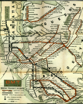
The Dual Contracts, also known as the Dual Subway System, were contracts for the construction and/or rehabilitation and operation of rapid transit lines in the City of New York. The contracts were signed on March 19, 1913, by the Interborough Rapid Transit Company and the Brooklyn Rapid Transit Company. As part of the Dual Contracts, the IRT and BRT would build or upgrade several subway lines in New York City, then operate them for 49 years.

<span class="mw-page-title-main">IRT Ninth Avenue Line</span> Former New York City rapid transit line

The IRT Ninth Avenue Line, often called the Ninth Avenue Elevated or Ninth Avenue El, was the first elevated railway in New York City. It opened in July 1868 as the West Side and Yonkers Patent Railway, as an experimental single-track cable-powered elevated railway from Battery Place, at the south end of Manhattan Island, northward up Greenwich Street to Cortlandt Street. It ceased operation in June 1940, after it was replaced by the IND Eighth Avenue Line which had opened in 1932.

<span class="mw-page-title-main">BMT Lexington Avenue Line</span> Former New York City rapid transit line

The BMT Lexington Avenue Line was the first standard elevated railway in Brooklyn, New York, operated in its later days by the Brooklyn Rapid Transit Company, the Brooklyn–Manhattan Transit Corporation, and then the City of New York.

<span class="mw-page-title-main">Park Row Terminal</span> Former BMT elevated station (closed 1944)

The Park Row station was a major elevated railway terminal constructed on the Manhattan side of the Brooklyn Bridge, across from New York City Hall and the IRT’s elevated City Hall station. It served as the terminal for BMT services operating over the Brooklyn Bridge Elevated Line from the BMT Fulton Street Line, BMT Myrtle Avenue Line and their feeders. Until the opening of the nearby Williamsburg Bridge to elevated train traffic in 1913, it was the only Manhattan station available for elevated trains from Brooklyn, and the only elevated station in Manhattan to be owned by a company other than the IRT or its predecessors.

<span class="mw-page-title-main">Ninth Avenue (Manhattan)</span> North-south avenue in Manhattan, New York

Ninth Avenue, known as Columbus Avenue between West 59th and 110th Streets, is a thoroughfare on the West Side of Manhattan in New York City. Traffic runs downtown (southbound) along the full stretch from Chelsea to the Upper West Side, except for the lowermost three blocks where traffic runs northbound carrying traffic from Greenwich Street.

<span class="mw-page-title-main">Fulton Center</span> Transit center and mall in Manhattan, New York

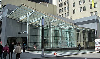
Fulton Center is a subway and retail complex centered at the intersection of Fulton Street and Broadway in Lower Manhattan, New York City. The complex was built as part of a $1.4 billion project by the Metropolitan Transportation Authority (MTA), a public agency of the state of New York, to rehabilitate the New York City Subway's Fulton Street station. The work involved constructing new underground passageways and access points into the complex, renovating the constituent stations, and erecting a large station building that doubles as a part of the Westfield World Trade Center mall.

<span class="mw-page-title-main">Downtown Hudson Tubes</span>

The Downtown Hudson Tubes are a pair of tunnels that carry PATH trains under the Hudson River in the United States, between New York City to the east and Jersey City, New Jersey, to the west. The tunnels run between the World Trade Center station on the New York side and the Exchange Place station on the New Jersey side.

<span class="mw-page-title-main">Hudson Terminal</span> Former building complex in Manhattan, New York

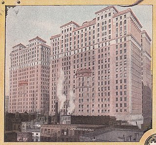
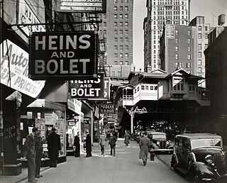
The Hudson Terminal was a rapid transit station and office-tower complex in the Radio Row neighborhood of Lower Manhattan in New York City. Opened during 1908 and 1909, it was composed of a terminal station for the Hudson & Manhattan Railroad (H&M), as well as two 22-story office skyscrapers and three basement stories. The complex occupied much of a two-block site bounded by Greenwich, Cortlandt, Church, and Fulton Streets, which later became the World Trade Center site.

<span class="mw-page-title-main">Dey Street Passageway</span>

The Dey Street Passageway or Dey Street Concourse is a 350-foot-long (110 m) underground passageway in Manhattan, New York City, built as part of the Fulton Center project to rehabilitate the Fulton Street station complex and improve connectivity in Lower Manhattan. The Dey Street Passageway lies under Dey Street in Lower Manhattan, between Broadway in the eastern end, and Church Street in its western end.

<span class="mw-page-title-main">West Broadway</span> Street in Manhattan, New York

West Broadway is a north-south street in the New York City borough of Manhattan, separated into two parts by Tribeca Park. The northern part begins at Tribeca Park, near the intersection of Avenue of the Americas, Walker Street and Beach Street in Tribeca. It runs northbound as a one-way street past Canal Street and becomes two-way at the intersection with Grand Street one block farther north. West Broadway then operates as a main north-south thoroughfare through SoHo until its northern end at Houston Street, on the border between SoHo and Greenwich Village. North of Houston Street, it is designated as LaGuardia Place, which continues until Washington Square South.

<span class="mw-page-title-main">Greenwich Street</span> Street in Manhattan, New York

Greenwich Street is a north–south street in the New York City borough of Manhattan. It extends from the intersection of Ninth Avenue and Gansevoort Street in the Meatpacking District at its northernmost end to its southern end at Battery Park. Greenwich Street runs through the Meatpacking District, the West Village, Hudson Square, and Tribeca.

<span class="mw-page-title-main">Fulton Street station (New York City Subway)</span> New York City Subway station complex in Manhattan

The Fulton Street station is a major New York City Subway station complex in Lower Manhattan. It consists of four linked stations on the IND Eighth Avenue Line, the IRT Lexington Avenue Line, the BMT Nassau Street Line and the IRT Broadway–Seventh Avenue Line. The complex is served by the 2, 4, A, and J trains at all times. The 3, 5, and C trains stop here at all times except late nights, and the Z stops during rush hours in the peak direction.

<span class="mw-page-title-main">195 Broadway</span> Office skyscraper in Manhattan, New York

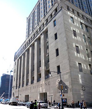
195 Broadway, also known as the Telephone Building, Telegraph Building, or Western Union Building, is an early skyscraper on Broadway in the Financial District of Manhattan, New York City. It was the longtime headquarters of AT&T as well as Western Union. It occupies the entire western side of Broadway from Dey Street to Fulton Street.

<span class="mw-page-title-main">Church Street and Trinity Place</span> North-south street in Manhattan, New York

Church Street and Trinity Place form a single northbound roadway in Lower Manhattan, New York City. Its northern end is at Canal Street and its southern end is at Morris Street, where Trinity Place merges with Greenwich Street. The dividing point is Liberty Street.

<span class="mw-page-title-main">Cortlandt Street (Manhattan)</span> Street in Manhattan, New York

Cortlandt Street is a west-east street in the Financial District of Lower Manhattan, New York City. It runs one block from Broadway to Church Street, then continues an additional block as the non-vehicular Cortlandt Way from Church to Greenwich Street. At its eastern end, the street continues as Maiden Lane.

<span class="mw-page-title-main">Chambers Street–World Trade Center/Park Place/Cortlandt Street station</span> New York City Subway station complex in Manhattan

The Chambers Street–World Trade Center/Park Place/Cortlandt Street station is a New York City Subway station complex on the IND Eighth Avenue Line, IRT Broadway–Seventh Avenue Line, and BMT Broadway Line. Located on Church Street between Chambers and Cortlandt Streets in Lower Manhattan, it is served by the:

References

  1. "History". Onrust.
  2. "Fragment from the Dutch ship 'Tyger'", Luce Center, New York Historical Society
  3. 1 2 "The "Holy Ground"". The New Yorker. September 9, 2002.
  4. Greene, Richard Henry; Stiles, Henry Reed; Dwight, Melatiah Everett; Morrison, George Austin; Totten, John Reynolds; Mott, Hopper Striker; Ditmas, Charles Andrew; Pitman, Harold Minot; Forest, Louis Effingham De; Mann, Conklin; Maynard, Arthur S. (March 9, 1876). "The New York Genealogical and Biographical Record". New York Genealogical and Biographical Society via Google Books.
  5. Valentine, David Thomas. History of the city of New-York, G.P. Putnam & Company, 1853, p. 280 PD-icon.svg This article incorporates text from this source, which is in the public domain .
  6. "Nash, Stephen P., Anneke Jans Bogardus: her farm, 1896, p. 58, note" (PDF).
  7. "Dey Mansion Washington's Headquarters". deymansion.
  8. "streets of new york". oldstreets.com.
  9. Society, New-York Historical (March 9, 1918). "The New-York Historical Society Quarterly Bulletin". The Society via Google Books.
  10. "The Real Estate Market". March 8, 1872. p. 5 via newspapers.com.
  11. Stern, Robert A. M.; Mellins, Thomas; Fishman, David (1999). New York 1880: Architecture and Urbanism in the Gilded Age. Monacelli Press, p. 398 ISBN   978-1-58093-027-7
  12. Feuer, Alan (December 24, 2009). "Lots of Sparkle for a Swift Fall" via NYTimes.com.
  13. ""Associated Press Moves Today", The New York Times, April 6, 1914" (PDF).
  14. "Streetscapes/AT&T Headquarters at 195 Broadway; A Bellwether Building Where History Was Made - The New York Times". The New York Times . March 10, 2020. Archived from the original on 2020-03-10.
  15. "AT&T's new downtown Dallas campus will have a place for its historic statue". Dallas News. July 22, 2019.
  16. Postal, Matthew (July 31, 2018). "AT&T Corporate Headquarters Building (later Sony Plaza, now 550 Madison Avenue)" (PDF). New York City Landmarks Preservation Commission. Archived (PDF) from the original on September 7, 2018. Retrieved February 9, 2020.
  17. Walsh, Kevin (September 28, 2018). "DEY STREET". Forgotten New York.
  18. Dunlap, David W. (July 26, 2006). "Manhattan: AT&T Building Landmarked". The New York Times. ISSN   0362-4331 . Retrieved February 9, 2020.
  19. "nycsubway.org: The 9th Avenue Elevated-Polo Grounds Shuttle". www.nycsubway.org.
  20. "Abandoned Stations : Hudson Terminal". www.columbia.edu.
  21. "A $5,000,000 Tunnel Station". New-York Tribune. April 3, 1907. p. 8. Retrieved September 28, 2020 via newspapers.com.
  22. "Three Great Contracts". The Real Estate Record: Real Estate Record and Builders' Guide. Vol. 77, no. 1994. June 2, 1906. p. 1043 via columbia.edu.
  23. New York (N Y. ) Board of Estimate and Apportionment (1913). Minutes of the Board of Estimate and Apportionment of the City of New York. M. B. Brown Printing & Binding Company. p. 3030.
  24. "Bedlam on Radio Row: Downtown Mart Continues its Musical Pandemonium, But Meantime Sells Cameras and Golf Balls." The New York Times, May 25, 1930, p. 144
  25. Walsh, Kevin (November 7, 2017). "BROADWAY DEY". Forgotten New York.

Coordinates: 40°42′40″N74°00′39″W / 40.7110°N 74.0107°W / 40.7110; -74.0107