Robert and Anne Dickey House

Last updated

Robert and Anne Dickey House
Elizabeth Berger Plaza td (2022-04-22) 84 - Dickey House.jpg
The house in 2022, looking from Trinity Place
Robert and Anne Dickey House
General information
Architectural style Federal
Location67 Greenwich Street
Financial District, Manhattan, New York
Coordinates 40°42′26″N74°00′49″W / 40.707188°N 74.013685°W / 40.707188; -74.013685
Construction started1809
Completed1810
Technical details
Floor count4
DesignatedJune 28, 2005
Reference no.2166
References
[1] [2]

The Robert and Anne Dickey House, also referred to as the Robert Dickey House [3] or by its address 67 Greenwich Street, is a Federal-style building in the Financial District of Lower Manhattan in New York City. The site is bounded by Edgar Street to the south, Greenwich Street to the west, and Trinity Place to the east. It is named after Robert Dickey, a 19th-century New York merchant, and his wife Anne, who both resided in the house. [2] [3] Erected circa 1810, it is one of the few remaining Federal-style buildings in the city, [2] and became a New York City designated landmark in 2005. Having stood for over 200 years, surviving the construction of several subway lines and the Brooklyn–Battery Tunnel, as well as the September 11 attacks, the building has been labeled as a "Robert Moses survivor" and "The Indestructible Townhouse". [4] [5]

Contents

At the time of its landmarking, the building stood vacant and in disrepair. Beginning in the late 2010s, the Dickey House was restored as part of the construction of the adjacent 77 Greenwich Street apartment tower, to be used as part of Public School 150. [5]

Site

The Dickey House is the south end of a block bounded by Edgar Street to the south, Greenwich Street to the west, Trinity Place to the east, and Rector Street to the north. [1] [6] Immediately to the house's north was a former Syms Corporation store, demolished in 2017 to make way for the future 77 Greenwich Street tower. [6] [7] Located to the south across Edgar Street is Elizabeth H. Berger Plaza. [1] Also immediately to the south are the approaches to the Brooklyn–Battery Tunnel. [1] [8] [9] To the west and north at Greenwich and Rector Streets is 88 Greenwich Street. One block north of the site on Trinity Place are Trinity Church and the American Stock Exchange Building. To the immediate southwest across the Battery Tunnel approaches is 21 West Street. [8] [9]

The Dickey House is directly served by several New York City Subway stops. The Rector Street station of the IRT Broadway–Seventh Avenue Line ( 1 train) is located under Greenwich Street, and a station of the same name is located on the BMT Broadway Line ( N , R , and W trains) under Trinity Place. The Wall Street and Bowling Green stations of the IRT Lexington Avenue Line ( 4 and 5 trains) are located under Broadway east of the site. [8] The M55 local bus serves the site on Trinity Place (northbound) and Broadway (southbound). Numerous express bus routes to/from outer boroughs also operate in the area. [8] [10] The Staten Island Ferry Whitehall Terminal is located south of the site, connected by the subway or bus. [8]

Architecture

The original front face of the building on Greenwich Street in 2022, following restoration. Elizabeth Berger Plaza td (2022-09-07) 40 - Dickey House.jpg
The original front face of the building on Greenwich Street in 2022, following restoration.

The building was designed by an unknown architect in the Federal style. [1] [11] [12] The design has been erroneously attributed to Pierre Charles L'Enfant. [2] [3] As originally constructed the house was 3 12 stories tall, with the top 12 story occupied by a peaked roof. [1] [11] An 1872 alteration by architect Detlef Lienau replaced the peaked roof with a fourth story capped by a flat roof with a metal cornice. [1] [11] The front face of the building on Greenwich Street is flat and four-windows wide. [1] The bottom floor is utilized for retail space. [1]

As of 2011, the Dickey House is one of only seven surviving pre-1810 houses located south of Chambers Street. [1] [11] The building, however, has been in disrepair since the turn of the 21st century. [2] Currently, the house is hollowed out, with its roof and chimney removed to facilitate construction of 77 Greenwich, after which the building will be restored in the original style. As a result, only three outer faces (Greenwich, Edgar, Trinity) currently make up the building, while the construction and restoration are ongoing. [7]

Form and facade

The rear face of the building on Trinity Street is five bays wide. It features an "elliptical" or "bow-shaped" facade, which occupies the northernmost three windows and extends outward towards the street. This was an original design feature, and the 1872 remodeling maintained this element for the fourth floor. [2] [3] [11] The elliptical design has been compared to that of buildings in Boston. [13] The ellipse originally faced a garden on the property. [14]

The south facade on Edgar Street contains a chimney and no windows. [1] It was originally adjacent to another building, until that building was demolished and Edgar Street was relocated north to front the building during the construction of the Battery Tunnel in the 1940s. [1] [15] Windows may have existed on this face in the past. [14] The south face was later used as a billboard. [1] [12] [13] [16] The outer facade of the house consists of red brick, but the front (Greenwich) and rear (Trinity) faces have been painted gray. [1] [12] A one-story "commercial addition" was constructed in 1922 on the Trinity Place side of the building. [1] [6] This addition was most recently used as a tavern. [1] [12]

As part of the construction of 77 Greenwich Street, the Dickey House will be renovated and converted for use as a public elementary school building. The school will occupy both the house and portions of the lower floors of the tower. The exterior will be restored to its 19th-century condition. The 1922-built retail addition, considered non-historical, will be removed to create a new entrance to the building. Part of the new tower will cantilever over the house. The project was designed by FXFOWLE. The house will be renovated by the New York City School Construction Authority. [6] [7] [17]

History

Mrs. Robert Dickey (Anne Brown) MET DP205027.jpg
Robert Dickey MET ap69.22.1.jpg
Paintings of Anne Dickey (left) and Robert Dickey circa 1810, by John Wesley Jarvis

Robert Dickey and Anne Dickey (née Brown) were both born in what is now Northern Ireland, and later emigrated to the United States. Robert Dickey arrived in the U.S. in 1798. The two married in Baltimore, Maryland in 1807. [18] [19] [20] [21] Robert Dickey was a spice merchant, whose fortunes put him among the wealthiest men in New York City at the time. [1] [3] [19]

The lower ends of Greenwich Street and Trinity Place were created circa 1790, when a "bluff" created by the Hudson River tides was leveled and filled in order to be developed. [22]

Construction and 19th century

In 1809, Robert Dickey purchased three lots at the south end of Greenwich Street. Two of the lots were originally owned by Comfort Sands and given to his daughters in 1796. One of his daughters was the wife of New York banker and broker Nathaniel Prime. [1] Dickey proceeded to construct two houses on the site, addressed 69 and 71 Greenwich Street (later 65 and 67). Stables and a storehouse fronting Trinity Place (then called Lumber Street) were also built on adjacent lots. [1] [23] At the time, Greenwich Street was known as "Millionaire's Row" and later called the "Original Park Avenue", and the two houses were among numerous other Federal-style rowhouses on the street. [1] [22] Dickey acquired the adjacent 73 Greenwich Street (future 69 Greenwich) in 1816, while selling 69 Greenwich. [1] He operated his business ventures from the rear of the property on Lumber Street. [1] In 1821, Dickey sold the two remaining houses. [1] In 1822, the New York City Common Council established the modern building addresses on Greenwich Street; 71 Greenwich Street was renamed 67 Greenwich Street. [1]

The Ninth Avenue (left) and Sixth Avenue (right) elevated lines merging near the Dickey House circa 1893 (King1893NYC) pg695 BIRD'S-EYE VIEW FROM THE WASHINGTON BUILDING; LOOKING NORTHWEST.jpg
The Ninth Avenue (left) and Sixth Avenue (right) elevated lines merging near the Dickey House circa 1893

The house was transferred to Peter Schermerhorn (brother of Abraham Schermerhorn) in 1823, and the Schermerhorn family owned the building through the 19th century. [1] During this time, the house was rented out to prominent New Yorkers. These included William Bayard Jr., Nicholas Low, and Ezra Ludlow (father of William H. Ludlow). [1] It also served as the French Consulate building from 1830 to 1831. [1] By the 1840s, it became a boarding house. [1]

In the late 1860s, construction began on the Ninth Avenue Elevated railroad along Greenwich Street in front of the house. The elevated line opened in 1868. Shortly afterwards, the Sixth Avenue Line was erected above Trinity Place (then called New Church Street), with the two lines merging at Morris Street. This meant that both the front and rear faces of the Dickey House were obstructed by elevated tracks. [1] [14] [15] In April 1871, the house was among several in Lower Manhattan raided by police under the suspicion of prostitution. [14] [24] In 1872, Peter's son Edmund Schermerhorn contracted Detlef Lienau to remodel the house, removing the hipped roof and adding the building's fourth floor. [1] By this time, the building was used as a tenement, with the original upper class residents of the neighborhood having relocated uptown and immigrants taking their place. [1] [22] An 1890 police census reported 57 tenants of Irish descent occupying the house. [1]

Early and mid-20th century

The house was sold in 1919 to Rose A. McGuigan. [1] [25] One year later, McGuigan (also spelled "McGuigman") filed plans to convert the house and the adjacent 65 Greenwich Street property into a six-story office building. [26] Around this time, the surrounding neighborhood west of Greenwich Street developed into an Arab immigrant community known as Little Syria. [27] In 1922, the one-story shop extension was constructed on Trinity Place. [1]

The Dickey House looking from Trinity Place in 1940. Note the adjacent buildings on both sides, and the one-story shops in front of the house. Historic American Buildings Survey (Fed.), Stanley P. Mixon, Photographer Mar. 23, 1940, (K) EXT. VIEW OF REAR BAY FROM TRINITY STREET. - Greenwich Street Study (Plot plan), New HABS NY,31-NEYO,54-11.tif
The Dickey House looking from Trinity Place in 1940. Note the adjacent buildings on both sides, and the one-story shops in front of the house.

The Sixth and Ninth Avenue elevated lines were closed in 1938 and 1940 respectively, and dismantled in the 1940s. [1] [28] [29] During the construction of the Brooklyn–Battery Tunnel in that decade, numerous buildings in the neighborhood were demolished. This included many on Greenwich Street, and most of Little Syria. The Dickey House, however, remained, with Edgar Street moved north to the south face of the house. [13] [15] [16] [22] Because of this, the house would later be described as a "Robert Moses survivor". [4]

In 1960, the Dickey House was purchased by brothers-in-law Irving Schachter and Eli Goldhagen. [1] At this time, the building was used by a paper company. [13]

Landmark status and redevelopment

The house was first nominated for possible landmark status in 1967. [2] [16] On February 11, 1991, the New York State Historic Preservation Office identified the building as a potential state or national landmark. [30] By the turn of the 21st century, the house was in a state of disrepair. [2] Following the September 11 attacks, the building was vacated. [13] [16] On June 28, 2005, the house was designated as a city landmark by the New York City Landmarks Preservation Commission. [1] [2] [11] The designation was opposed by Martha Schachter Schessel and Harry Schessel, who were the owners of the house and the descendants of Irving Schachter. They wanted the building to be demolished. [12] [16] [4] [31] The family claimed restoration costs would run to $6 million. [4]

In 2008, it was revealed that the Syms Corporation, who owned and operated a store in the adjacent building (42 Trinity Place), planned to develop a multi-story tower on the shop site. To do this, they would need to purchase air rights from adjacent buildings including the Dickey House. [32] In May 2008, Syms purchased the Dickey House. [33] In November 2011, Syms filed for bankruptcy and closed all of its locations in January 2012. [34]

Beginning in late 2014, Syms (now reorganized as Trinity Place Holdings) planned to construct a residential and retail tower on the former store. [35] By 2016, the project was named 77 Greenwich Street. The plan would incorporate the Dickey House into the development, renovating the house for use as an elementary school. [6] [7] [17] Demolition of the Syms building was complete in October 2017. At this time, the chimney and north face of 67 Greenwich were removed, and metal support beams were installed to maintain the house's structural integrity. [7]

Related Research Articles

<span class="mw-page-title-main">Greenwich Village</span> Neighborhood of Manhattan in New York City

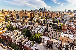
Greenwich Village, or simply the Village, is a neighborhood on the west side of Lower Manhattan in New York City, bounded by 14th Street to the north, Broadway to the east, Houston Street to the south, and the Hudson River to the west. Greenwich Village also contains several subsections, including the West Village west of Seventh Avenue and the Meatpacking District in the northwest corner of Greenwich Village.

<span class="mw-page-title-main">Sixth Avenue</span> North/south avenue in Manhattan, New York City, also known as Avenue of the Americas

Sixth Avenue – also known as Avenue of the Americas, although this name is seldom used by New Yorkers – is a major thoroughfare in New York City's borough of Manhattan, on which traffic runs northbound, or "uptown". It is commercial for much of its length.

<span class="mw-page-title-main">8th Street and St. Mark's Place</span> West-east street in Manhattan, New York

8th Street is a street in the New York City borough of Manhattan that runs from Sixth Avenue to Third Avenue, and also from Avenue B to Avenue D; its addresses switch from West to East as it crosses Fifth Avenue. Between Third Avenue and Avenue A, it is named St. Mark's Place, after the nearby St. Mark's Church in-the-Bowery on 10th Street at Second Avenue.

<span class="mw-page-title-main">Fulton Street (Brooklyn)</span> Street in Brooklyn, New York

Fulton Street is a long east–west street in northern Brooklyn, New York City. This street begins at the intersection of Adams Street and Joralemon Street in Brooklyn Heights, and runs eastward to East New York and Cypress Hills. At the border with Queens, Fulton Street becomes 91st Avenue, which ends at 84th Street in Woodhaven.

<span class="mw-page-title-main">West Village</span> Neighborhood of Manhattan in New York City

The West Village is a neighborhood in the western section of the larger Greenwich Village neighborhood of Lower Manhattan, New York City. The West Village is bounded by the Hudson River to the west and 14th Street to the north. The eastern boundary is variously cited as Greenwich Avenue, Seventh Avenue, or Sixth Avenue, while the southern boundary is either Houston Street or Christopher Street.

<span class="mw-page-title-main">Rector Street station (BMT Broadway Line)</span> New York City Subway station in Manhattan

The Rector Street station is a local station on the BMT Broadway Line of the New York City Subway. Located at the corner of Rector Street and Trinity Place in Financial District, Lower Manhattan, the station is served by the R train at all times except late nights, when the N train takes over service. The W train also serves this station on weekdays.

<span class="mw-page-title-main">Avenue B (Manhattan)</span> Avenue in Manhattan, New York

Avenue B is a north–south avenue located in the Alphabet City area of the East Village neighborhood of Manhattan, New York City, east of Avenue A and west of Avenue C. It runs from Houston Street to 14th Street, where it continues into a loop road in Stuyvesant Town, to be connected with Avenue A. Below Houston Street, Avenue B continues as Clinton Street to South Street. It is the eastern border of Tompkins Square Park.

<span class="mw-page-title-main">American Surety Building</span> Office building in Manhattan, New York

The American Surety Building is an office building and early skyscraper at Pine Street and Broadway in the Financial District of Manhattan in New York City, across from Trinity Church. The building, designed in a Neo-Renaissance style by Bruce Price with a later expansion by Herman Lee Meader, is 388 feet (118 m) tall, with either 23 or 26 stories. It was one of Manhattan's first buildings with steel framing and curtain wall construction.

<span class="mw-page-title-main">Lafayette Street</span> Street in Manhattan, New York

Lafayette Street is a major north–south street in New York City's Lower Manhattan. It originates at the intersection of Reade Street and Centre Street, one block north of Chambers Street. The one-way street then successively runs through Chinatown, Little Italy, NoLIta, and NoHo and finally, between East 9th and East 10th streets, merges with Fourth Avenue. A buffered bike lane runs outside the left traffic lane. North of Spring Street, Lafayette Street is northbound (uptown)-only; south of Spring Street, Lafayette is southbound (downtown)-only.

<span class="mw-page-title-main">Church Street and Trinity Place</span> North-south street in Manhattan, New York

Church Street and Trinity Place form a single northbound roadway in Lower Manhattan, New York City. Its northern end is at Canal Street and its southern end is at Morris Street, where Trinity Place merges with Greenwich Street. The dividing point is Liberty Street.

<span class="mw-page-title-main">South Village</span> Neighborhood of Manhattan in New York City

The South Village is a largely residential area that is part of the larger Greenwich Village in Lower Manhattan, New York City, directly below Washington Square Park. Known for its immigrant heritage and bohemian history, the architecture of the South Village is primarily tenement-style apartment buildings, indicative of the area's history as an enclave for Italian-American immigrants and working-class residents of New York.

<span class="mw-page-title-main">Vesey Street</span> Street in Manhattan, New York

Vesey Street is a street in New York City that runs east-west in Lower Manhattan. The street is named after Rev. William Vesey (1674–1746), the first rector of nearby Trinity Church.

<span class="mw-page-title-main">Friends Meetinghouse and School</span> United States historic place

The Friends Meetinghouse and School is a Quaker meeting house and adjacent school building at the corner of Schermerhorn Street and Boerum Place in the Boerum Hill neighborhood of Brooklyn, New York City.

<span class="mw-page-title-main">Francis F. Palmer House</span> Historic houses in Manhattan, New York

The Francis F. Palmer House is the centerpiece of a complex of residential buildings located at 67, 69, and 75 East 93rd Street in New York City, known collectively as the George F. Baker Jr. Houses. They were completed during the years 1918–1931 to the designs of the architecture firm Delano & Aldrich. In 1982, the entire ensemble was added as a group to the National Register of Historic Places.

<span class="mw-page-title-main">2 Horatio Street</span> Co-op apartment in New York , U.S.

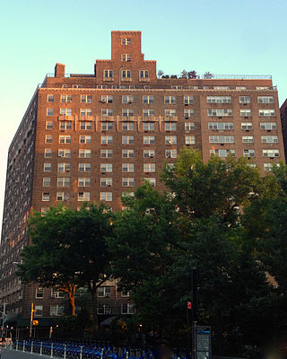
2-10 Horatio Street is a 17-story co-operative apartment building located between Greenwich and Eighth Avenues, on the corner of Greenwich Avenue, across from Jackson Square Park in the Greenwich Village neighborhood of Manhattan, New York City, United States. Built in 1929–31 and designed by Robert T. Lyons, the building is located within the Greenwich Village Historic District, but is not an individual landmark. The building also has the address 123-129 Greenwich Avenue.

<span class="mw-page-title-main">American Stock Exchange Building</span> Building in Manhattan, New York

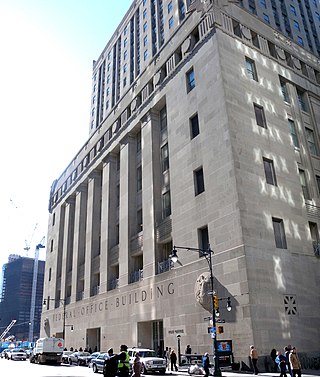
The American Stock Exchange Building, formerly known as the New York Curb Exchange Building and also known as 86 Trinity Place or 123 Greenwich Street, is the former headquarters of the American Stock Exchange. Designed in two sections by Starrett & van Vleck, it is located between Greenwich Street and Trinity Place in the Financial District of Lower Manhattan in New York City, with its main entrance at Trinity Place. The building represents a link to the historical practices of stock trading outside the strictures of the New York Stock Exchange (NYSE), which took place outdoors "on the curb" prior to the construction of the structure.

<span class="mw-page-title-main">Elizabeth H. Berger Plaza</span> Plaza in Manhattan, New York

Elizabeth H. Berger Plaza is a public park in the Financial District of Manhattan, New York City. formed by the triangular junction of Trinity Place, Greenwich Street and Edgar Street. It faces the Manhattan exit ramp from the Brooklyn–Battery Tunnel. Formerly known as the Edgar Street Greenstreet, this park honors civic advocate Elizabeth H. Berger (1960-2013). In her role as president of the Downtown Alliance, she advocated for the fusion of two traffic triangles at this location into an expanded park. The park is located on the site of a former neighborhood known as Little Syria, a bustling immigrant community displaced by the construction of the tunnel in 1953.

<span class="mw-page-title-main">William Colford Schermerhorn</span> American lawyer, philanthropist, and patron of the arts

William Colford Schermerhorn was an American lawyer, philanthropist, and patron of the arts.

<span class="mw-page-title-main">Trinity and United States Realty Buildings</span> Buildings in Manhattan, New York

The Trinity Building, designed by Francis H. Kimball and built in 1905, with an addition of 1907, and Kimball's United States Realty Building of 1907, located respectively at 111 and 115 Broadway in Manhattan's Financial District, are among the first Gothic-inspired skyscrapers in New York, and both are New York City designated landmarks. The Trinity Building, adjacent to the churchyard of Richard Upjohn's neo-Gothic Trinity Church, replaced an 1853 Upjohn structure of the same name. Earlier, the Van Cortlandt sugar house stood on the west end of the plot – a notorious British prison where American soldiers were held during the Revolutionary War.

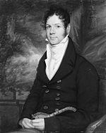
Edmund Henry Schermerhorn was an American businessman of New York's Dutch Schermerhorn family.

References

  1. 1 2 3 4 5 6 7 8 9 10 11 12 13 14 15 16 17 18 19 20 21 22 23 24 25 26 27 28 29 30 31 32 33 34 35 36 37 "ROBERT and ANNE DICKEY HOUSE, 67 Greenwich Street (aka 28-30 Trinity Place), Manhattan. Built 1809-10" (PDF). nyc.gov. New York City Landmarks Preservation Commission. June 28, 2005. Archived (PDF) from the original on March 16, 2018. Retrieved June 28, 2017.
  2. 1 2 3 4 5 6 7 8 9 "Endangered Buildings Initiative: 67 Greenwich St". New York Landmarks Conservancy . Retrieved January 30, 2018.
  3. 1 2 3 4 5 Dunlap, David W. (September 15, 1991). "Hidden Corners of Lower Manhattan". The New York Times . Retrieved January 30, 2018.
  4. 1 2 3 4 "LANDMARKS PRESERVATION COMMISSION: Owners challenge designation" (PDF). CityLand . Vol. 2, no. 4. May 15, 2005. pp. 60–61. Retrieved January 31, 2018.
  5. 1 2 Gill, John Freeman (April 9, 2021). "The Indestructible Townhouse". The New York Times . Retrieved September 10, 2022.
  6. 1 2 3 4 5 "ROBERT AND ANNE DICKEY HOUSE: 67 GREENWICH STREET" (PDF). nyc.gov . Trinity Place Holdings, FXFOWLE. February 16, 2016. Retrieved January 30, 2018.
  7. 1 2 3 4 5 Young, Michael (October 20, 2017). "Excavation Begins For FXFOWLE-Designed 77 Greenwich Street, Financial District". New York Yimby. Retrieved January 30, 2018.
  8. 1 2 3 4 5 "MTA Neighborhood Maps: Lower Manhattan" (PDF). Metropolitan Transportation Authority. 2015. Retrieved October 1, 2018.
  9. 1 2 "NYCityMap". NYC.gov. New York City Department of Information Technology and Telecommunications . Retrieved March 20, 2020.
  10. "Manhattan Bus Map" (PDF). Metropolitan Transportation Authority. July 2019. Retrieved December 1, 2020.
  11. 1 2 3 4 5 6 Diamonstein-Spielvogel, Barbaralee (2011). The Landmarks of New York (5th ed.). Albany, New York: State University of New York Press. p. 95. ISBN   978-1-4384-3769-9.
  12. 1 2 3 4 5 Dunlap, David W. (June 20, 2003). "Downtown, Federal Era Blooms In Hiding". The New York Times . Retrieved January 30, 2018.
  13. 1 2 3 4 5 Amateau, Albert (August 20, 2003). "13 Federal-style buildings are eyed as landmarks". The Villager . Archived from the original on January 31, 2018. Retrieved January 30, 2018.
  14. 1 2 3 4 Gray, Christopher (July 6, 2003). "Streetscapes/Readers' Questions; A Statue of Joan of Arc, and a Curved Facade". The New York Times . Retrieved January 30, 2018.
  15. 1 2 3 Barbara Rizek; Martin Rizek; Joanne Medvecky (2004). The Financial District's Lost Neighborhood: 1900-1970. Arcadia Publishing. pp. 2, 12–13, 20. ISBN   978-0-7385-3511-1 . Retrieved January 30, 2018.
  16. 1 2 3 4 5 "After 38 years, Greenwich St. building is finally landmarked". The Villager . July 6, 2005. Archived from the original on January 31, 2018. Retrieved January 30, 2018.
  17. 1 2 Weiss, Lois (January 27, 2016). "Trinity Place complex gets a new look — and a new name". New York Post . Retrieved January 30, 2018.
  18. Tunis Garret Bergen (1915). Genealogies of the State of New York: A Record of the Achievements of Her People in the Making of a Commonwealth and the Founding of a Nation. Lewis Historical Publishing Company. pp. 522–. Retrieved January 30, 2018.
  19. 1 2 John Caldwell; Oswaldo Rodriguez Roque; Dale T. Johnson (March 1, 1994). American Paintings in The Metropolitan Museum of Art. Vol. 1: A Catalogue of Works by Artists Born by 1815. Metropolitan Museum of Art. pp. 296–299. GGKEY:5A107H6P5DU. Retrieved January 30, 2018.
  20. Biographical Sketches of the Leading Men of Chicago. Wilson & St. Clair. 1868. pp.  429. Retrieved January 30, 2018.
  21. John Crosby Brown (1909). A hundred years of merchant banking: a history of Brown Brothers and Company, Brown, Shipley & Company and the allied firms. Alexander Brown and Sons, Baltimore; William and James Brown and Company, Liverpool; John A. Brown and Company, Browns and Bowen, Brown Brothers and Company, Philadelphia; Brown Brothers and Company, Boston. Priv. Print. pp.  329. Retrieved January 30, 2018.
  22. 1 2 3 4 Skidmore, Howard F. (April 14, 1946). "Battery Tunnel Maw Swallowing Citrus Original Park Avenue: Oldest Neighborhood, Once ihe Best, Laler a Polyglot Village, Awaits Wreckers". New York Herald Tribune . ProQuest, New York Public Library. p. A11.
  23. "House 67 Greenwich Street". New York Daily Advertiser . Fultonhistory.com. January 23, 1823. Retrieved January 31, 2018.
  24. "BREAKING UP THE BAGNIOS.; Twenty-nine Houses of Ill-Fame Suppressed in the First Ward Thirty Men and Ninety-two Women Incarcerated in the Tombs". The New York Times . April 8, 1871. Retrieved January 30, 2018.
  25. "Old Trow Printing Plant To Be Used for Business". New-York Tribune . Fultonhistory.com. October 22, 1919. p. 19. Retrieved January 31, 2018.
  26. "Plans Filed for Big "Village" "Show House: 2,332-Seated Theater Will Cover Block and Will Cost $400,000 to Build". New-York Tribune . Fultonhistory.com. March 25, 1920. p. 19. Retrieved January 30, 2018.
  27. Parsons, Walter B. (March 21, 1920). "SYRIAN BUSINESS SECTION CHANGING". The New York Times . Retrieved January 31, 2018.
  28. "6th Ave. 'L' to Shut Down At Midnight Tomorrow". The New York Times . December 3, 1938. Retrieved January 31, 2018.
  29. "Two 'El' Lines End Transit Service". New York Times . June 12, 1940. p. 27.
  30. Allee King Rosen and Fleming, Inc. (May 1994). Route 9A Reconstruction Project: Final Environmental Impact Statement; Appendix C: Cultural Resources. New York State Department of Transportation, Federal Highway Administration, United States Department of Transportation. pp. C-20−C-21. Retrieved March 18, 2018.
  31. Satow, Julie (October 19, 2004). "Downtown Home Could Be Given Landmark Status". The New York Sun . Retrieved January 31, 2018.
  32. Covert, James (April 29, 2008). "Flagship Makeover". New York Post . Retrieved January 30, 2018.
  33. Chatelain, Ryan (July 17, 2008). "10 historic New York buildings now eyesores". AM New York . Retrieved January 30, 2018.
  34. Fleming, Ashley; Dominguez, Robert (November 2, 2011). "Syms and Filene's Basement file for bankruptcy and will close all stores by January". New York Daily News . Retrieved January 30, 2018.
  35. Dailey, Jessica (December 17, 2014). "Trinity Place Development Site Could Sprout This Tower". Curbed . Retrieved January 31, 2018.