Lower Manhattan, also known as Downtown Manhattan, is the southernmost part of the New York City borough of Manhattan. The area is the historical birthplace of New York City[1] and in the 17th and 18th centuries composed the entirety of the city. Lower Manhattan serves as the seat of government of both Manhattan and the entire City of New York.[1] Because there are no municipally defined boundaries for the area, a precise population cannot be quoted, but several sources have suggested that it was one of the fastest-growing locations in New York City between 2010 and 2020, related to the influx of young adults and significant development of new housing units.[2][3]
Lower Manhattan is delineated on the north by 14th Street, on the west by the Hudson River, on the east by the East River, and on the south by New York Harbor. Its northern border is designated by thoroughfares about a mile-and-a-half south of 14th Street and a mile north of Manhattan's southern tip around Chambers Street near the Hudson River east of the entrances and overpass to the Brooklyn Bridge.[6] Two other major arteries to Lower Manhattan are Canal Street, roughly half a mile north of Chambers Street, and 23rd Street, roughly half a mile north of 14th Street.
The area that would eventually encompass modern-day New York City was inhabited by the Lenape people. These groups of culturally and linguistically identical Native Americans who spoke an Algonquian language now referred to as Unami. European settlement began with the founding of a Dutchfur trading post in Lower Manhattan, later called New Amsterdam (Dutch: Nieuw-Amsterdam) in 1626.[9][10] The first fort was built at The Battery to protect New Netherland.[11]
In approximately 1626, construction of Fort Amsterdam began.[11] The Dutch West Indies Company subsequently imported African slaves to serve as laborers; they helped to build the wall that defended the town against English and native attacks. Early directors included Willem Verhulst and Peter Minuit. Willem Kieft became a director in 1638 but five years later was embroiled in Kieft's War against the Native Americans. The Pavonia Massacre, across the Hudson River in present-day Jersey City, New Jersey resulted in the death of 80 natives in February 1643. Following the massacre, Algonquian tribes joined forces and nearly defeated the Dutch. The Dutch Republic sent additional forces to the aid of Kieft, leading to the overwhelming defeat of the Native Americans and a peace treaty on August 29, 1645.[12]:37–40
On May 27, 1647, Peter Stuyvesant was inaugurated as director general upon his arrival. The colony was granted self-government in 1652, and New Amsterdam was formally incorporated as a city on February 2, 1653.[12]:57 The first mayors (burgemeesters) of New Amsterdam, Arent van Hattem and Martin Cregier, were appointed in that year.[13]
In 1664, the English conquered the area and renamed it "New York" after the Duke of York and the city of York in Yorkshire.[14][15] At that time, people of African descent made up 20% of the population of the city, with European settlers numbering approximately 1,500,[16]:14 and people of African descent numbering 375 (with 300 of that 375 enslaved and 75 free).[16]:22 While it has been claimed that African slaves comprised 40% of the small population of the city at that time,[17] this claim has not been substantiated. During the mid-1600s, farms of free blacks covered 130 acres (53ha) where Washington Square Park later developed.[18] The Dutch briefly regained the city in 1673, renaming the city "New Orange", before permanently ceding the colony of New Netherland to the English for what is now Suriname in November 1674. The new English rulers of the formerly Dutch New Amsterdam and New Netherland renamed the settlement back to New York. As the colony grew and prospered, sentiment also grew for greater autonomy. In the context of the Glorious Revolution in England, Jacob Leisler led Leisler's Rebellion and effectively controlled the city and surrounding areas from 1689 to 1691, before being arrested and executed.
By 1700, the Lenape population of New York had diminished to 200.[19] By 1703, 42% of households in New York had slaves, a higher percentage than in Philadelphia or Boston.[20] The 1735 libel trial of John Peter Zenger in the city was a seminal influence on freedom of the press in North America. It would be a standard for the basic articles of freedom in the United States Declaration of Independence. By the 1740s, with expansion of settlers, 20% of the population of New York were slaves, totaling about 2,500 people.[18] After a series of fires in 1741, the city became panicked that blacks planned to burn the city in a conspiracy with some poor whites. Historians believe their alarm was mostly fabrication and fear, but officials rounded up 31 blacks and 4 whites, all of whom were convicted of arson and executed. City officials executed 13 blacks by burning them alive and hanged 4 whites and 18 blacks.[21]
New York City was greatly damaged twice by fires of suspicious origin during British military rule. The city became the political and military center of operations for the British in North America for the remainder of the war and a haven for Loyalist refugees. Continental Army officer Nathan Hale was hanged in Manhattan for espionage. In addition, the British began to hold the majority of captured American prisoners of war aboard prison ships in Wallabout Bay, across the East River in Brooklyn. More Americans died from neglect aboard these ships than died in all the battles of the war. British occupation lasted until November 25, 1783. George Washington triumphantly returned to the city that day, as the last British forces left the city.
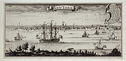
Sidney's Map Twelve Miles Around New York, 1849 lithograph by James Charles SidneyCooper Union at Astor Place, one of Lower Manhattan's most storied buildings, where Abraham Lincoln gave his famed Cooper Union speech on February 27, 1860
In 1898, the modern City of New York was formed with the consolidation of Brooklyn (until then an independent city), Manhattan and outlying areas.[28] The borough of Brooklyn incorporated the independent City of Brooklyn, recently joined to Manhattan by the Brooklyn Bridge in Lower Manhattan. Municipal governments contained within the boroughs were abolished, and the county governmental functions, housed in Lower Manhattan after unification, were absorbed by the city or each borough.[29]
Despite these road connections opening, the economic center of New York City began to shift from Lower Manhattan to Midtown with the opening of many commuter rail terminals at the turn of the 20th century. The original Penn Station opened in 1910,[35] the Hudson and Manhattan Railroad (now PATH) extension to 33rd Street was completed in 1910,[36] and Grand Central Terminal opened in 1913.[37]
On March 25, 1911, the Triangle Shirtwaist Factory fire in Greenwich Village took the lives of 146 garment workers, which would eventually lead to great advancements in the city's fire department, building codes, and workplace regulations.
Throughout the first half of the 20th century, New York became a world center for industry, commerce, and communication. Interborough Rapid Transit, the first New York City Subway company, began operating in 1904. The area's demographics stabilized, labor unionization brought new protections and affluence to the working class, the city's government and infrastructure underwent a dramatic overhaul under Fiorello La Guardia, and his controversial parks commissioner, Robert Moses, ended the 'blight' of many tenement areas, by demolishing slums, factories, and working-class neighborhoods through public works such as the High line, the West Side Highway and FDR Drive, built housing projects, expanded new parks, rebuilt streets, and zoning controls, especially in Lower Manhattan. The zoning changes were intended to displace the industrial workforce by removing zoning protection for industrial space and incentivizing upscale residential and clerical redevelopment. The port of New York, despite its physical suitability for berthing and its close proximity to Europe, began to deteriorate due to the city's unwillingness to invest or modernise the port and the deindustrialization zoning policy. However a large number of small scale, dynamic, and highly specialized industries persisted despite the city's efforts such as the garment industry which was closely tied to the fashion industry in Midtown, or the printing industry; linked with the publishing industry.
In the 1950s, a few new buildings were constructed in Lower Manhattan, including an 11-story building at 156 William Street in 1955.[38] A 27-story office building at 20 Broad Street, a 12-story building at 80 Pine Street, a 26-story building at 123 William Street, and a few others were built in 1957.[38] By the end of the decade, Lower Manhattan had become economically depressed, in comparison with Midtown Manhattan, which was booming with the continued march uptown. David Rockefeller spearheaded widespread urban renewal efforts in Lower Manhattan, beginning with constructing One Chase Manhattan Plaza, the new headquarters for his bank. He established the Downtown-Lower Manhattan Association (DLMA) which drew up plans for broader revitalization of Lower Manhattan, with the development of a proposed World Trade Center at the heart of these plans. The original DLMA plans called for the "world trade center" to be built along the East River, between Old Slip and Fulton Street. After negotiations with New Jersey Governor Richard J. Hughes, the Port Authority decided to build the World Trade Center on a site along the Hudson River and the West Side Highway, rather than the East River site.[citation needed]
When building the World Trade Center, 1.2million cubic yards (917,000m3) of material was excavated from the site.[39] Rather than dumping the spoil at sea or in landfills, the fill material was used to expand the Manhattan shoreline across West Street, creating Battery Park City.[40] The result was a 700-foot (210-m) extension into the river, running six blocks or 1,484 feet (452m), covering 92 acres (37ha), providing a 1.2-mile (1.9km) riverfront esplanade and over 30 acres (12ha) of parks.[41]
Through much of its history, the area south of Chambers Street was mainly a commercial district, with a small population of residents—in 1960, it was home to about 4,000.[42] Construction of Battery Park City, on landfill from construction of the World Trade Center, brought many new residents to the area. Gateway Plaza, the first Battery Park City development, was finished in 1983. The project's centerpiece, the World Financial Center, consists of four luxury highrise towers. By the turn of the century, Battery Park City was mostly completed, with the exception of some ongoing construction on West Street. Around this time, Lower Manhattan reached its highest population of business tenants and full-time residents.[citation needed] These developments struggled to become fully occupied at desirable rents, with relatively high vacancy rates.[43]
In 1993, the Downtown Lower Manhattan Association contributed to a city plan calling for the revitalization of Lower Manhattan. The plan included recommended zoning changes, tax incentives to encourage new tenants, and the conversion of commercial buildings into apartments. It also called for the creation of a business improvement district, called The Alliance for Downtown New York, to help spur the area's renewal. Between 1995 and 2014, 15.8 million square feet of office space was converted to residential or hotel use. As a result, Lower Manhattan's residential population rose from 14,000 to 60,000.[44]
In the early 21st century, the Meatpacking District, once the sparsely populated province of after-hours BDSM clubs and transgender prostitutes, gained a reputation as New York City's trendiest neighborhood.[45]
September 11 attacks
During the September 11 attacks in 2001, two of four hijacked planes were flown into the Twin Towers of the original World Trade Center, and the towers collapsed. The 7 World Trade Center was not struck by a plane but uncontrolled fires that were caused by falling debris resulted in the building's collapse; a first in the history of steel framed skyscrapers.[46] The 3, 4, 5, and 6 World Trade Center buildings were damaged beyond repair or destroyed, and soon after demolished. The collapse of the Twin Towers also caused extensive damage to surrounding buildings and skyscrapers in Lower Manhattan. A total of 2,753 people, including those on the planes, were killed in New York.[47] About 400,000 people, including rescue workers and residents of the area were exposed to toxic dust and debris; many developed serious respiratory illnesses, cancers, and other harms arising from the attack, and 3,496 died.[48]
Post-9/11 rebuilding
Following September 11, Lower Manhattan lost much of its economy and office space but has since rebounded significantly. Private sector employment reached 233,000 at the end of 2016, the highest levels since the end of 2001. This was largely due to growth and diversification in the local workforce with gains in employment sectors like Technology, Advertising, Media and Information, as well as Hotel, Restaurants, Retailing, and Health care.[49] As of 2016, Lower Manhattan's business district is home to approximately 700 retail stores and 500 bars and restaurants.[50]
The Lower Manhattan Development Corporation has consummated plans to rebuild downtown Manhattan by adding new streets, buildings, and office space. The National September 11 Memorial at the site was opened to the public on September 11, 2011, while the National September 11 Museum was officially inaugurated by President Barack Obama on May 15, 2014.[51] As of the time of its opening in November 2014, the new One World Trade Center, formerly known as the Freedom Tower, is the tallest skyscraper in the Western Hemisphere[52] and the sixth-tallest in the world, at 1,776 feet (541m);[53] while other skyscrapers are under construction at the site.
On October 29 and 30, 2012, Hurricane Sandy ravaged portions of Lower Manhattan with record-high storm surge from New York Harbor, severe flooding, and high winds, causing power outages for hundreds of thousands of Manhattanites and leading to gasoline shortages and disruption of mass transit systems. The storm and its effects have prompted the discussion of constructing seawalls and other coastal barriers around the shorelines of Manhattan and the New York City metropolitan region to minimize the risk of destructive consequences from another such event in the future.[55]
Lower Manhattan has been experiencing a baby boom, well above the overall birth rate in Manhattan, with the area south of Canal Street witnessing 1,086 births in 2010, 12% greater than 2009 and over twice the number born in 2001.[56] The Financial District alone saw its population grow to approximately 43,000 as of 2014, nearly double the 23,000 recorded at the 2000 Census.[57]
In June 2015, The New York Times wrote that Lower Manhattan's dining scene was experiencing a renaissance.[60] There are over 400 casual dining and more than 100 full-service dining restaurants in the area.[61]The Village Voice, based at 80 Maiden Lane in the Financial District and historically the largest alternative newspaper in the United States, announced in 2017 that it would cease publication of its print edition and convert to a fully digital venture.[62]
Since 2010, a Lower Manhattan community known as Little Australia has emerged and is growing in the Nolita neighborhood.[63]
Since the early-20th century, Lower Manhattan has been an important center for the arts and leisure activities. Greenwich Village was a locus of bohemian culture from the first decade of the century through the 1980s. Several of the city's leading jazz clubs are still located in Greenwich Village, which was also one of the primary bases of the American folk music revival of the 1960s. Many art galleries were located in SoHo between the 1970s and early 1990s; today, the downtown Manhattan gallery scene is centered in Chelsea. From the 1960s onward, Lower Manhattan has been home to many alternative theater companies, constituting the heart of the Off-Off-Broadway community.
Punk rock and its musical derivatives emerged in the mid-1970s largely at two Lower Manhattan venues, CBGB on Bowery in the western edge of the East Village, and Max's Kansas City on Park Avenue South. At the same time, the area's surfeit of appropriated industrial lofts, played an integral role in the development and sustenance of the minimalist composition, free jazz, disco, and electronic dance music subcultures. The area's many nightclubs and bars, though mostly shorn of the freewheeling iconoclasm, pioneering spirit, and do-it-yourself mentality that characterized the pre-gentrification era, still draw patrons from throughout the city and the surrounding region.
Downtown in the context of Manhattan, and of New York City generally, has different meanings to different people, especially depending on where in the city they reside. Residents of the island or of The Bronx generally speak of going "downtown" to refer to any southbound excursion to any Manhattan destination.[66] A declaration that one is going to be "downtown" may indicate a plan to be anywhere south of 14th Street—the definition of downtown according to the city's official tourism marketing organization[66]—or even 23rd Street.[67][68] The full phrase Downtown Manhattan may also refer more specifically to the area of Manhattan south of Canal Street.[42] Within business-related contexts, many people use the term Downtown Manhattan to refer only to the Financial District and the corporate offices in the immediate vicinity. For instance, the Business Improvement District managed by the Alliance for Downtown New York defines Downtown as south of Murray Street (essentially South of New York City Hall), which includes the World Trade Center area and the Financial District. The phrase Lower Manhattan may apply to any of these definitions: the broader ones often if the speaker is discussing the area in relation to the rest of the city; more restrictive ones, again, if the focus is on business matters or on the colonial and early post-colonial history of the island.[citation needed]
As reflected in popular culture, "Downtown" in Manhattan has historically represented a place where one could "forget all your troubles, forget all your cares, and go Downtown," as the lyrics of Petula Clark's 1964 hit "Downtown" celebrate (although Tony Hatch, the songwriter of the track, later clarified that he naively believed Times Square to be "downtown", and was the actual inspiration for the hit single). The protagonist of Billy Joel's 1983 hit "Uptown Girl" contrasts himself (a "downtown man") with the purportedly staid uptown world.[69] Likewise, the chorus of Neil Young's 1995 single "Downtown" urges "Let's have a party, downtown all right."
Lower Manhattan is the third-largest business district in the United States, after Midtown Manhattan and the Chicago Loop.[73] Anchored by Wall Street in Lower Manhattan, New York City functions as the financial and fintech center of the world and has been called the world's most economically powerful city.[4][74][75][76] Lower Manhattan is home to the New York Stock Exchange, at 11 Wall Street, and the corporate headquarters of NASDAQ, at 165 Broadway, representing the world's largest and second largest stock exchanges, respectively, when measured both by overall average daily trading volume and by total market capitalization of their listed companies in 2013.[77] Wall Street investment banking fees in 2012 totaled approximately US$40billion.[78][79]
Other large companies with headquarters in Lower Manhattan include (in alphabetical order):
↑"Chinatown New York". Civitatis New York. Archived from the original on April 4, 2020. Retrieved March 23, 2024. As its name suggests, Chinatown is where the largest population of Chinese people live in the Western Hemisphere.
Sarah Waxman. "The History of New York's Chinatown". Mediabridge Infosystems, Inc. Archived from the original on May 25, 2017. Retrieved March 23, 2024. Manhattan's Chinatown, the largest Chinatown in the United States and the site of the largest concentration of Chinese in the Western Hemisphere, is located on the Lower East Side.
↑Homberger, Eric (2005). The Historical Atlas of New York City: A Visual Celebration of 400 Years of New York City's History. Owl Books. p.34. ISBN0-8050-7842-8.
↑Jackson, Kenneth (1995). Encyclopedia of New York City. New Haven: Yale University Press. p.206. "[B]orough presidents ... responsible for local administration and public works."
↑Millstein, Gilbert (April 24, 1960). "Restless Ports for the City's Food". The New York Times.
↑Questions and Answers about the NIST WTC 7 InvestigationArchived January 14, 2024, at the Wayback Machine , National Institute of Standards and Technology, created May 24, 2010, updated September 21, 2016. Accessed August 31, 2023. "Debris from the collapse of WTC 1, which was 370 feet to the south, ignited fires on at least 10 floors in the building at its south and west faces.... The heat from the uncontrolled fires caused steel floor beams and girders to thermally expand, leading to a chain of events that caused a key structural column to fail. The failure of this structural column then initiated a fire-induced progressive collapse of the entire building.... The collapse of WTC 7 is the first known instance of a tall building brought down primarily by uncontrolled fires."
↑Shaun Busuttil (November 3, 2016). "G-day! Welcome to Little Australia in New York City". KarryOn. Retrieved May 24, 2019. In Little Australia, Australian-owned cafes are popping up all over the place (such as Two Hands), joining other Australian-owned businesses (such as nightclubs and art galleries) as part of a growing green and gold contingent in NYC. Indeed, walking in this neighbourhood, the odds of your hearing a fellow Aussie ordering a coffee or just kicking back and chatting are high – very high – so much so that if you're keen to meet other Aussies whilst taking your own bite out of the Big Apple, then this is the place to throw that Australian accent around like it's going out of fashion!
↑Jones, Huw (September 4, 2018). "United States top, Britain second in financial activity: think-tank". Thomson Reuters. Retrieved September 4, 2018. Think-tank New Financial's study, which focuses on the "raw" value of actual domestic and international financial activity like managing assets and issuing equity, underscored the overall dominance of New York as the world's top financial center.
↑"Large Employer Group ApplicationArchived 2013-05-12 at the Wayback Machine ". EmblemHealth. Retrieved on August 12, 2011. "EmblemHealth, 55 Water Street, New York, New York 10041 HIP Insurance Company of New York, 55 Water Street, New York, NY 10041 Group Health Incorporated, 441 Ninth Avenue, New York, NY 10001"
This page is based on this Wikipedia article Text is available under the CC BY-SA 4.0 license; additional terms may apply. Images, videos and audio are available under their respective licenses.


