West Side Stadium was a proposed football and Olympic stadium to be built on a platform over the rail yards on the West Side of Manhattan in New York City.
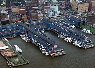
Chelsea Piers is a series of piers in Chelsea, on the West Side of Manhattan in New York City. Located to the west of the West Side Highway and Hudson River Park and to the east of the Hudson River, they were originally a passenger ship terminal in the early 1900s that was used by RMS Lusitania and was the destination of RMS Carpathia after rescuing the survivors of RMS Titanic. The piers replaced a variety of run-down waterfront structures with a row of grand buildings embellished with pink granite facades.

The New York City 2012 Olympic bid was one of the five short-listed bids for the 2012 Summer Olympics, ultimately won by London.

Hudson Yards is a neighborhood on the West Side of Midtown Manhattan in New York City, bounded roughly by 30th Street in the south, 41st Street in the north, the West Side Highway in the west, and Eighth Avenue in the east. The area is the site of a large-scale redevelopment program that is being planned, funded, and constructed under a set of agreements among the State of New York, City of New York, and Metropolitan Transportation Authority (MTA), with the aim of expanding the Midtown Manhattan business district westward to the Hudson River. The program includes a major rezoning of the Far West Side, an extension of the New York City Subway's 7 and <7> trains to a new subway station at 34th Street and 11th Avenue, a renovation and expansion of the Javits Center, and a financing plan to fund the various components. The various components are being planned by New York City Department of City Planning and New York City Economic Development Corporation.
Vanderbilt Avenue is the name of three thoroughfares in the New York City boroughs of Brooklyn, Manhattan, and Staten Island. They were named after Cornelius Vanderbilt (1794–1877), the builder of Grand Central Terminal in Midtown Manhattan.

The East River Tunnels are four single-track railroad passenger service tunnels that extend from the eastern end of Pennsylvania Station under 32nd and 33rd Streets in Manhattan and cross the East River to Long Island City in Queens. The tracks carry Long Island Rail Road (LIRR) and Amtrak trains travelling to and from Penn Station and points to the north and east. The tracks also carry New Jersey Transit trains deadheading to Sunnyside Yard. They are part of Amtrak's Northeast Corridor, used by trains traveling between New York City and New England via the Hell Gate Bridge.

The Port of New York and New Jersey is the port district of the New York-Newark metropolitan area, encompassing the region within approximately a 25-mile (40 km) radius of the Statue of Liberty National Monument.

Hudson River Park is a waterfront park on the North River that extends from 59th Street south to Battery Park in the New York City borough of Manhattan. The park, a component of the Manhattan Waterfront Greenway, stretches 4.5 miles (7.2 km) and comprises 550 acres (220 ha), making it the second-largest park in Manhattan after the 843-acre (341 ha) Central Park.
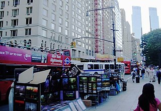
59th Street is a crosstown street in the New York City borough of Manhattan, running from York Avenue and Sutton Place on the East Side of Manhattan to the West Side Highway on the West Side. The three-block portion between Columbus Circle and Grand Army Plaza is known as Central Park South, since it forms the southern border of Central Park. There is a gap in the street between Ninth Avenue/Columbus Avenue and Columbus Circle, where the Deutsche Bank Center is located. While Central Park South is a bidirectional street, most of 59th Street carries one-way traffic.
The Manhattan Waterfront Greenway is a waterfront greenway for walking or cycling, 32 miles (51 km) long, around the island of Manhattan, in New York City. The largest portions are operated by the New York City Department of Parks and Recreation. It is separated from motor traffic, and many sections also separate pedestrians from cyclists. There are three principal parts — the East, Harlem and Hudson River Greenways.

Dyckman Street, occasionally called West 200th Street, is a street in the Inwood neighborhood of Manhattan, New York City. It is commonly considered to be a crosstown street because it runs from the Hudson River to the Harlem River and intersects Broadway. However, in its true geographical orientation, Dyckman Street runs roughly from north-northwest to south-southeast, and the majority of the street that lies southeast of Broadway runs closer to a north-south direction than east-west.

Jerome Avenue is one of the longest thoroughfares in the New York City borough of the Bronx, New York, United States. The road is 5.6 miles (9.0 km) long and stretches from Concourse to Woodlawn. Both of these termini are with the Major Deegan Expressway which runs parallel to the west. Most of the elevated IRT Jerome Avenue Line runs along Jerome Avenue. The Cross Bronx Expressway interchanges with Jerome and the Deegan. Though it runs through what is now the West Bronx neighborhood, Jerome Avenue is the dividing avenue between nominal and some named "West" and "East" streets in the Bronx; Fifth Avenue, and to a lesser extent, Broadway, also splits Manhattan into nominal "West" and "East" streets.

Manhattan West is a 7-million-square-foot (650,000 m2) mixed-use development by Brookfield Properties, built as part of the Hudson Yards Redevelopment. The project spans 8 acres and features four office towers, one boutique hotel, one residential building, 225,000 square feet (20,900 m2) of retail space and a 2.5-acre public plaza. The project was built on a platform over Penn Station storage tracks along Ninth Avenue between 32nd and 33rd Streets.

The West Side Yard is a rail yard of 30 tracks owned by the Metropolitan Transportation Authority on the west side of Manhattan in New York City. Used to store commuter rail trains operated by the subsidiary Long Island Rail Road, the 26.17-acre (10.59 ha) yard sits between West 30th Street, West 33rd Street, 10th Avenue and 12th Avenue. Since the early 2010s, the eastern part of the yard has been covered by the Hudson Yards complex of skyscrapers and other buildings.

Spuyten Duyvil and Port Morris Railroad was a railroad built in what is today the West Bronx and South Bronx in New York City, United States. It ran from the junction between the West Side Line and the Hudson River Railroad near Spuyten Duyvil Creek, then along the Harlem River to the northwestern shore of the East River in what is today the Port Morris section of the Bronx.

Midtown South is a macro-neighborhood of the borough of Manhattan in New York City, generally characterized as constituting the southern portion of Midtown Manhattan. Midtown Manhattan hosts over 700,000 daily employees as a busy hub for workers, residents, and tourists. The Empire State Building, the Flatiron Building, Pennsylvania Station, Madison Square Garden, the Macy's Herald Square flagship store, Koreatown, and NYU Langone Medical Center are all located in Midtown South.
Bridge Park is a park in the Bronx, New York, created as part of a larger vision of creating connected waterfront parks along both sides of the Harlem River. The park's name references three large arch bridges linking Manhattan and the Bronx: Alexander Hamilton Bridge, Washington Bridge, and High Bridge.
Hudson Yards is a 28-acre (11 ha) real estate development in the Hudson Yards neighborhood in Manhattan, New York City, between the Chelsea and Hell's Kitchen neighborhoods. It is located on the waterfront of the Hudson River. Related Companies and Oxford Properties are the primary developers and major equity partners in the project. The architectural firm Kohn Pedersen Fox designed the master plan for the site, and the following architects contributed designs for individual structures: Skidmore, Owings, and Merrill, Thomas Heatherwick, Foster + Partners, Roche-Dinkeloo, and Diller Scofidio + Renfro. Major office tenants include Tapestry, BCG, Warner Bros. Discovery, L'Oréal, Wells Fargo, and KKR.

St. John's Terminal, also known as 550 Washington Street, is a building on Washington Street in the Hudson Square neighborhood of Manhattan in New York City. Designed by Edward A. Doughtery, it was built in 1934 by the New York Central Railroad as a terminus of the High Line, an elevated freight line along Manhattan's West Side used for transporting manufacturing-related goods. The terminal could accommodate 227 train cars. The three floors, measuring 205,000 square feet (19,000 m2) each, were the largest in New York City at the time of their construction.
