Manhattan Community Board 5

Last updated
Manhattan Community District 5
CommBoard5 map.jpg
CountryFlag of the United States.svg  United States
State Flag of New York.svg  New York
City Flag of New York City.svg New York City
Borough Flag of the Borough of Manhattan.svg Manhattan
Neighborhoods
Government
  ChairpersonVikki Barbero
  District ManagerMarisa Maack
Area
  Land1.6 sq mi (4 km2)
Population
 (2010)
  Total51,673
Ethnicity
  Hispanic and Latino Americans15.5%
  African-American5.2%
  White59.1%
  Asian17.2%
  Others3.0%
Time zone UTC−5 (Eastern)
  Summer (DST) UTC−4 (EDT)
ZIP codes
10003, 10010, 10011, 10016, 10017, 10018, 10019, 10020, 10022, 10036, 100111
Area code 212, 646, and 332, and 917
Police Precinct
Website www.cb5.org ,
[1] [2]

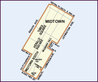
Manhattan Community Board 5 is a New York City community board, part of the local government apparatus of the city, with the responsibility for the neighborhoods of Midtown, Times Square, most of the Theater District, the Diamond District, the Garment District, Herald Square, Koreatown, NoMad, Murray Hill and the Flatiron District, all in the borough of Manhattan. It is bounded by 59th Street on the north, Eighth Avenue, 26th Street, the Avenue of the Americas ("Sixth Avenue") on the west, 14th Street on the south, and Lexington Avenue on the east, excluding the area from 34th to 40th Streets between Madison and Lexington Avenues, and the area from 20th to 22nd Streets between Park Avenue South and Lexington Avenue/Irving Place.

Contents

Within the area under the Board's responsibility are all or part of the Murray Hill, Madison Square North, Ladies' Mile, Gramercy Park and East 17th Street/Irving Place historic districts. [3] Business Improvement Districts in the area include Madison Avenue BID, East Midtown Association, Fifth Avenue BID, the Times Square Alliance, 47th Street BID, the Grand Central Partnership, Bryant Park Management, Garment Center District, 34th Street Partnership, Madison Square Park Conservancy, Flatiron/23rd Street Partnership, and Union Square Partnership. [4]

Within its boundaries are the neighborhoods of Flatiron, Herald Square, Midtown, Midtown South, Times Square, and Union Square. [5] It may also include portions of Gramercy Park and Murray Hill. [6] [7] [8]

Demographics

As of the 2010 Census, the Community Board's area has a population of 51,000, up from 44,000 in the 2000 Census (+17%). With a land area of 1.6 square miles, the District has a population density of 32,296 persons per square mile. [6]

According to the American Community Survey, 59.1% are White (down from 72.3% in 2000), 5.2% are African-American (up from 4.4%), 17.2% are Asian or Pacific Islander (up from 14%), 15.5% are Hispanic (up from 6.7%), and 3% are another group. [6]

A total of 30.8% of the area's population is foreign born. [6]

The land area under the Board's purview is 1,046.4 acres, or 1.64 square miles (4.23 km²).

Built Environment

Zoning

The majority of Manhattan 5's zoning by land area is Commercial (82.57%), followed by Manufacturing zoning (14.22%). Residences and Parks comprise 1.6% each. [6]

Community Assets

Manhattan 5 has 13 public schools, 7 public libraries, 23 hospitals and clinics, and 3 parks, [6] Bryant Park, Madison Square Park, and Union Square Park.

Related Research Articles

<span class="mw-page-title-main">Broadway (Manhattan)</span> Avenue in New York

Broadway is a road in the U.S. state of New York. Broadway runs from State Street at Bowling Green for 13 mi (20.9 km) through the borough of Manhattan and 2 mi (3.2 km) through the Bronx, exiting north from New York City to run an additional 18 mi (29.0 km) through the Westchester County municipalities of Yonkers, Hastings-On-Hudson, Dobbs Ferry, Irvington, and Tarrytown, and terminating north of Sleepy Hollow.

<span class="mw-page-title-main">Murray Hill, Manhattan</span> Neighborhood in New York City

Murray Hill is a neighborhood on the east side of Manhattan in New York City. Murray Hill is generally bordered to the east by the East River or Kips Bay and to the west by Midtown Manhattan, though the exact boundaries are disputed. Murray Hill is situated on a steep glacial hill that peaked between Lexington Avenue and Broadway. It was named after Robert Murray, the head of the Murray family, a mercantile family that settled in the area in the 18th century.

<span class="mw-page-title-main">Midtown Manhattan</span> Central business district in New York City

Midtown Manhattan is the central portion of the New York City borough of Manhattan and serves as the city's primary central business district. Midtown is home to some of the city's most prominent buildings, including the Empire State Building, the Chrysler Building, the Hudson Yards Redevelopment Project, the headquarters of the United Nations, Grand Central Terminal, and Rockefeller Center, as well as several prominent tourist destinations including Broadway, Times Square, and Koreatown. Penn Station in Midtown Manhattan is the busiest transportation hub in the Western Hemisphere.

<span class="mw-page-title-main">Flatiron District</span> Neighborhood of Manhattan in New York City anchored by the Flatiron Building.

<span class="mw-page-title-main">Union Square, Manhattan</span> Intersection and neighborhood in New York City

Union Square is a historic intersection and surrounding neighborhood in Manhattan, New York City, United States, located where Broadway and the former Bowery Road – now Fourth Avenue – came together in the early 19th century. Its name denotes that "here was the union of the two principal thoroughfares of the island". The current Union Square Park is bounded by 14th Street on the south, 17th Street on the north, and Union Square West and Union Square East to the west and east respectively. 17th Street links together Broadway and Park Avenue South on the north end of the park, while Union Square East connects Park Avenue South to Fourth Avenue and the continuation of Broadway on the park's south side. The park is maintained by the New York City Department of Parks and Recreation.

<span class="mw-page-title-main">Kips Bay, Manhattan</span> Neighborhood of Manhattan in New York City

Kips Bay, or Kip's Bay, is a neighborhood on the east side of the New York City borough of Manhattan. It is roughly bounded by East 34th Street to the north, the East River to the east, East 27th and/or 23rd Streets to the south, and Third Avenue to the west.

<span class="mw-page-title-main">Turtle Bay, Manhattan</span> Neighborhood of Manhattan in New York City

Turtle Bay is a neighborhood in New York City, on the east side of Midtown Manhattan. It extends from roughly 43rd Street to 53rd Street, and eastward from Lexington Avenue to the East River's western branch. The neighborhood is the site of the headquarters of the United Nations and the Chrysler Building. The Tudor City apartment complex is next to the southeast corner of Turtle Bay.

<span class="mw-page-title-main">Lexington Avenue</span> North-south avenue in Manhattan, New York

Lexington Avenue, often colloquially abbreviated as "Lex", is an avenue on the East Side of Manhattan in New York City. The avenue carries southbound one-way traffic from East 131st Street to Gramercy Park at East 21st Street. Along its 5.5-mile (8.9-kilometer), 110-block route, Lexington Avenue runs through Harlem, Carnegie Hill, the Upper East Side, Midtown, and Murray Hill to a point of origin that is centered on Gramercy Park. South of Gramercy Park, the axis continues as Irving Place from 20th Street to East 14th Street.

<span class="mw-page-title-main">Gramercy Park</span> Neighborhood and park in New York City

Gramercy Park is the name of both a small, fenced-in private park and the surrounding neighborhood that is referred to also as Gramercy, in Manhattan in New York City.

<span class="mw-page-title-main">Madison Square and Madison Square Park</span> Public square and park in Manhattan, New York City

Madison Square is a public square formed by the intersection of Fifth Avenue and Broadway at 23rd Street in the New York City borough of Manhattan. The square was named for Founding Father James Madison, fourth President of the United States. The focus of the square is Madison Square Park, a 6.2-acre (2.5-hectare) public park, which is bounded on the east by Madison Avenue ; on the south by 23rd Street; on the north by 26th Street; and on the west by Fifth Avenue and Broadway as they cross.

<span class="mw-page-title-main">Manhattan Community Board 6</span> Community District in New York, United States

Manhattan Community Board 6 is a New York City community board, part of the local government apparatus of the city, with responsibility for the East Side of Manhattan from 14th Street to 59th Street. This includes the neighborhoods of Gramercy Park, Stuyvesant Park, Stuyvesant Town, Peter Cooper Village, Rose Hill, Waterside Plaza, Murray Hill, Kips Bay, Turtle Bay, Tudor City, and Sutton Place. The eastern and western borders are the East River and Lexington Avenue, except between 34th Street and 40th Street, where the area extends west to Madison Avenue, and between 20th Street and 22nd Street where it extends west to Park Avenue South.

<span class="mw-page-title-main">Community boards of Manhattan</span>

Community boards of Manhattan are New York City community boards in the borough of Manhattan, which are the appointed advisory groups of the community districts that advise on land use and zoning, participate in the city budget process, and address service delivery in their district.

<span class="mw-page-title-main">Stuyvesant Square</span> Public park and neighborhood in Manhattan, New York

<span class="mw-page-title-main">Rose Hill, Manhattan</span> Neighborhood in Manhattan, New York City

<span class="mw-page-title-main">Lenox Hill</span>

<span class="mw-page-title-main">NoMad, Manhattan</span> Neighborhood in Manhattan, New York City

<span class="mw-page-title-main">Pershing Square, Manhattan</span> Plaza in Manhattan, New York

<span class="mw-page-title-main">Midtown South</span> Neighborhood of Manhattan in New York City

Midtown South is a macro-neighborhood of the borough of Manhattan in New York City, generally characterized as constituting the southern portion of Midtown Manhattan. Midtown Manhattan hosts over 700,000 daily employees as a busy hub for workers, residents, and tourists. The Empire State Building, the Flatiron Building, Pennsylvania Station, Madison Square Garden, the Macy's Herald Square flagship store, Koreatown, and NYU Langone Medical Center are all located in Midtown South.

References

Notes

  1. "NYC Community District Profiles". communityprofiles.planning.nyc.gov. Retrieved June 11, 2021.
  2. "mn05_profile.pdf" (PDF). docs.google.com. Retrieved June 11, 2021.
  3. "Historic Districts" Archived 2010-12-25 at the Wayback Machine on the Community Board 5 website
  4. "BIDs" on the Community Board 5 website
  5. Community Health Profiles 2015 - Manhattan Community District 5. "Manhattan Community District 5: MIDTOWN (Including Flatiron, Herald Square, Midtown, Midtown South, Times Square and Union Square)"
  6. 1 2 3 4 5 6 NYC Planning - Community District Profiles - Manhattan Community District 5. "Flatiron, Gramercy Park, Herald Square, Midtown, Midtown South, Murray Hill, Times Square, Union Square (Neighborhoods may be in multiple districts. Neighborhood names and boundaries are not officially designated.)"
  7. Neighborhood Tabulation Areas* within Manhattan Community District 5
  8. See Manhattan Community Board 5 map (retrieved 2006)