New York City Hall

Last updated

City Hall
New York City Landmark  No. 0080, 0916
New York City Hall exterior, October 2016.jpg
New York City Hall in October 2016
New York City Hall
Location City Hall Park
between Broadway and Park Row [1] [2]
Manhattan, New York City
Coordinates 40°42′46″N74°00′21″W / 40.7127°N 74.0059°W / 40.7127; -74.0059
Built1812
Architect Joseph-François Mangin and John McComb Jr.
Architectural styleexterior:
French Renaissance Revival
interior:
Georgian Revival
NRHP reference No. 66000539
NYSRHP No.06101.000408
NYCL No.0080, 0916
Significant dates
Added to NRHPOctober 15, 1966 [3]
Designated NHLDecember 19, 1960 [4]
Designated NYSRHPJune 23, 1980 [5]
Designated NYCLexterior: February 1, 1966
interior: January 17, 1976

New York City Hall is the seat of New York City government, located at the center of City Hall Park in the Civic Center area of Lower Manhattan, between Broadway, Park Row, and Chambers Street. Constructed from 1803 to 1812, [1] the building is the oldest city hall in the United States that still houses its original governmental functions. [6] The building houses the office of the Mayor of New York City and the chambers of the New York City Council. While the Mayor's Office is in the building, the staff of thirteen municipal agencies under mayoral control are located in the nearby Manhattan Municipal Building, one of the largest government buildings in the world, with many others housed in various buildings in the immediate vicinity.

Contents

New York City Hall is a National Historic Landmark and is listed on the National Register of Historic Places. [4] [7] [8] The New York City Landmarks Preservation Commission designated both City Hall's exterior and interior as official city landmarks in 1966 and 1976, respectively. [2]

History

17th century

New Amsterdam's first City Hall was built by the Dutch Republic in the 17th century near present-day 73 Pearl Street. [9] The first structure was demolished in 1690.

18th century

An 1887 illustration of New York City Municipal and Metropolitan policemen rioting and fighting each other in front of New York City Hall in 1857 NewYorkPoliceRiot.jpg
An 1887 illustration of New York City Municipal and Metropolitan policemen rioting and fighting each other in front of New York City Hall in 1857
City Hall at night in 2008 CityHallSpring 2 crop.jpg
City Hall at night in 2008

The city's second City Hall, built in 1700, stood on Wall and Nassau Streets. That building was renamed Federal Hall in 1789, after New York became the first official capital of the United States after the Constitution was ratified. It was demolished in 1812 and current Federal Hall was built in 1842.

Plans for building a new City Hall were discussed by the New York City Council as early as 1776, but the financial strains of the war delayed progress. The Council chose a site at the old Common at the northern limits of the city, now City Hall Park. City Hall was originally an area for the first almshouse in 1653. In 1736, there was a financed almshouse for those who were fit to work, for the unfit, and those that were like criminals but were paupers. [10]

19th century

In 1802, New York City held a competition for a new City Hall. The first prize of $350 was awarded to Joseph-François Mangin and John McComb Jr. Mangin studied architecture in his native France before becoming a New York City surveyor in 1795 and publishing an official map of the city in 1803 that was largely discredited for its inaccuracies. Mangin later served as the architect of the landmarked St. Patrick's Old Cathedral on Mulberry Street. McComb, whose father had worked on the old City Hall, was a New Yorker and designed Castle Clinton in Battery Park, among other buildings and structures. Mangin had no known involvement with City Hall after winning the commission. McComb alone supervised every aspect of construction and was in charge of the architectural modifications and detailing during the extended building process. [1]

The cornerstone of the new City Hall was laid on May 26, 1803. [11] Construction was delayed after the City Council objected that the design was too extravagant. In response, McComb reduced the size of the building and used brownstone at the rear of the building to lower costs. The brownstone, along with the original deteriorated Massachusetts marble facade, quarried from Alford, Massachusetts, was later replaced with Alabama limestone between 1954 [12] and 1956. Labor disputes and an outbreak of yellow fever further slowed construction. The building was not dedicated until 1811, and opened officially in 1812.

The New York City Police riot occurred in front of New York City Hall between the recently dissolved New York Municipal Police and the newly formed Metropolitan Police on June 16, 1857. Municipal police fought with Metropolitan officers who were attempting to arrest New York City Mayor Fernando Wood.

20th and 21st centuries

In 1953, the city's public works commissioner Frederick H. Zurmuhlen requested $2.2 million to repair City Hall's facade, which was crumbling. [13]

On July 23, 2003, at 2:08 p.m., City Hall was the scene of a rare political assassination. Othniel Askew, a political rival of City Councilman James E. Davis, opened fire with a pistol from the balcony of the City Council chamber. Askew shot Davis twice, fatally wounding him. A police officer on the floor of the chamber then fatally shot Askew. Askew and Davis had entered the building together without passing through a metal detector, a courtesy extended to elected officials and their guests. As a result of the security breach, then-Mayor Michael Bloomberg revised security policy to require that everyone entering the building pass through metal detectors without exception. [14]

In 2008, work began on a restoration of the building, after a century without a major renovation. The construction included structural enhancements, upgrades to building services, as well as in-depth restoration of much of the interior and exterior. Due to the complexity of the demands of the project, the New York City Department of Design and Construction hired Hill International to provide construction management. Renovations were originally estimated to cost $104 million and take four years, but ended up costing nearly $150 million and taking over five years. [15] [16]

CityHall 1911.JPG
City Hall, Park Row, and City Hall Park in 1911, including the Manhattan station for cable cars, which ran across the Brooklyn Bridge

Architecture

City Hall in the Historic American Buildings Survey with the Manhattan Municipal Building in the background (on the right) City Hall Skewed 120572pv.jpg
City Hall in the Historic American Buildings Survey with the Manhattan Municipal Building in the background (on the right)
The Chamber of the Board of Councilmen in 1868 Chamber of the Board of Councilmen 1868.jpg
The Chamber of the Board of Councilmen in 1868

Although Mangin and McComb designed the building, which was constructed between 1810 and 1812, it has been altered numerous times over the years by several architects: [1] :69 [2]

The architectural style of City Hall combines international architectural influences, French Renaissance and English neoclassicism. American-Georgian is more evident in the interior design. The design of City Hall influenced at least two later civic structures, the Tweed Courthouse and the Surrogate's Courthouse immediately to the north. City Hall is a New York City designated landmark. It is also listed on the New York State and National Registers of Historic Places.

Exterior

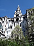
The building consists of a central pavilion with two projecting wings. The entrance, reached by a long flight of steps, has figured prominently in civic events for over a century and a half. There is a columned entrance portico capped by a balustrade, and another balustrade at the roof. The domed tower in the center was rebuilt in 1917 after the last of two major fires. The original Massachusetts marble facade, quarried from Alford, Massachusetts, and complemented with brownstone on the rear elevation, had deteriorated over time from pollution and pigeons. [17] :30 It was completely reclad in Alabama limestone above a Missouri granite base in 1954–56 by Shreve, Lamb & Harmon, architects of the Empire State Building. [17] :30,103

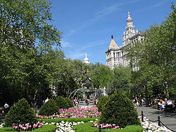
The steps of City Hall frequently provide a backdrop for political demonstrations and press conferences concerning city politics. Live, unedited coverage of events at City Hall is carried on NYC Media channel 74, a City Government-access television (GATV) official cable TV channel.

Fencing surrounds the building's perimeter, with a strong security presence by the New York City Police Department and other security. Public access to the building is restricted to tours and to those with specific business appointments.

Interior

The rotunda of New York City Hall City Hall Rotunda.jpg
The rotunda of New York City Hall

On the inside, the rotunda is a soaring space with a grand marble stairway rising up to the second floor, where ten fluted Corinthian columns support the coffered dome, which was added in a 1912 restoration by Grosvenor Atterbury. [2] The rotunda has been the site of municipal as well as national events. Abraham Lincoln's coffin was placed on the staircase landing across the rotunda when he lay in state in 1865 after his assassination. Ulysses S. Grant also lay in state beneath the soaring rotunda dome – as did Colonel Elmer Ephraim Ellsworth, first Union officer killed in the Civil War and commander of the 11th New York Volunteer Infantry Regiment (First Fire Zouaves).

There are 108 paintings from the late 18th century through the 20th century, which The New York Times declared were "almost unrivaled as an ensemble, with several masterpieces". [18] Among the collection is John Trumbull's 1805 portrait of Alexander Hamilton, the source of the face on the United States ten-dollar bill. There were significant efforts to restore the paintings in the 1920s and 1940s. In 2006, a new restoration campaign began for 47 paintings identified by the Art Commission as highest in priority.

Official receptions are held in the Governor's Room, which has hosted many dignitaries including the Marquis de Lafayette and Albert Einstein. The building's Governor's Room hosted President-elect Abraham Lincoln in 1861. The Governor's Room, which is used for official receptions, also houses one of the most important collections of 19th-century American portraiture and notable artifacts such as George Washington's desk.

Other notable rooms include:

Surroundings

City Hall Park City Hall Park - New York City.jpg
City Hall Park
The mezzanine at the subway station underneath City Hall City Hall station control room.jpg
The mezzanine at the subway station underneath City Hall
City Hall at dusk in 2007 Nyc city hall jan06a.jpg
City Hall at dusk in 2007

Neighborhood

The area around City Hall is commonly referred to as the Civic Center. Most of the neighborhood consists of government offices (city, state, and federal), as well as an increasing number of upscale residential dwellings being converted from older commercial structures. Architectural landmarks surround City Hall, including St. Paul's Chapel, St. Peter's Church, the Home Life Building, the Rogers Peet Building, and the Woolworth Building to the west; the Broadway–Chambers Building to the northwest; 280 Broadway, 49 Chambers, Tweed Courthouse, and Surrogate's Courthouse to the north; the Manhattan Municipal Building to the northeast; the Brooklyn Bridge to the east; and the New York Times Building, the Potter Building, and the Park Row Building to the southwest. City Hall Park is approximately three blocks away from the World Trade Center to the west. [19] Pace University's New York City campus is located across Park Row from City Hall. [20]

Subway stations

Located directly under City Hall Park is the former City Hall subway station, the original southern terminal of the first service of the New York City Subway built by the Interborough Rapid Transit Company (IRT). Opened on October 27, 1904, [21] this station beneath the public area in front of City Hall was designed to be the showpiece of the new subway. The platform and mezzanine feature Guastavino tile, skylights, colored glass tile work and brass chandeliers. [22] Passenger service was discontinued on December 31, 1945, [23] although the station is still used as a turning loop for 6 and <6> trains. [24]

Another station named City Hall ( N , R , and W trains) also exists on the BMT Broadway Line, albeit on the western side of City Hall and not directly under it. [25] This station was built in 1918 for the Brooklyn–Manhattan Transit Corporation (BMT). [26]

Other nearby, open subway stations are Brooklyn Bridge–City Hall/Chambers Street ( 4 , 5 , 6 , <6> , J , and Z trains) and Chambers Street–World Trade Center/Park Place/Cortlandt Street ( 2 , 3 , A , C , E , N , R , and W trains). [27]

As a geographic center

Google Maps uses New York City Hall as the zero-mile point from which distances from New York City are measured. [28]

New York City Hall is featured in the following films, television shows, and songs:

New York City Hall has played a central role in several films and television series. Examples include:

In the year of our Lord, eighteen hundred and six,
We set sail from the Coal Quay of Cork
We were sailing away with a cargo of bricks
For the grand City Hall in New York

See also

Related Research Articles

<span class="mw-page-title-main">Financial District, Manhattan</span> Neighborhood of Manhattan in New York City

The Financial District of Lower Manhattan, also known as FiDi, is a neighborhood located on the southern tip of Manhattan in New York City. It is bounded by the West Side Highway on the west, Chambers Street and City Hall Park on the north, Brooklyn Bridge on the northeast, the East River to the southeast, and South Ferry and the Battery on the south.

<span class="mw-page-title-main">Federal Hall</span> Memorial in Manhattan, New York

Federal Hall is a memorial and historic site at 26 Wall Street in the Financial District of Manhattan in New York City. The current Greek Revival–style building, completed in 1842 as the Custom House, is owned by the United States federal government and operated by the National Park Service as a national memorial called the Federal Hall National Memorial. The memorial is named for an earlier Federal style building on this same site, completed in 1703 as City Hall, which the government of the newly independent United States used as its capital building during the 1780s.

<span class="mw-page-title-main">City Hall station (IRT Lexington Avenue Line)</span> New York City Subway station, 1904–1945

The City Hall station, also known as City Hall Loop station, is a closed station on the IRT Lexington Avenue Line of the New York City Subway. It is located under City Hall Park, next to New York City Hall, in the Civic Center neighborhood of Manhattan in New York City. The station was constructed for the Interborough Rapid Transit Company (IRT) as the southern terminal of the city's first subway line, which was approved in 1900. Construction of the segment of the line that includes the City Hall station started on September 12 of the same year. The station opened on October 27, 1904, as one of the original 28 stations of the New York City Subway. As ridership grew, it was deemed infeasible to lengthen the original platform to accommodate ten-car trains. The station was closed on December 31, 1945, because of its proximity to the Brooklyn Bridge station.

<span class="mw-page-title-main">Union Square, Manhattan</span> Intersection and neighborhood in New York City

Union Square is a historic intersection and surrounding neighborhood in Manhattan, New York City, United States, located where Broadway and the former Bowery Road – now Fourth Avenue – came together in the early 19th century. Its name denotes that "here was the union of the two principal thoroughfares of the island". The current Union Square Park is bounded by 14th Street on the south, 17th Street on the north, and Union Square West and Union Square East to the west and east respectively. 17th Street links together Broadway and Park Avenue South on the north end of the park, while Union Square East connects Park Avenue South to Fourth Avenue and the continuation of Broadway on the park's south side. The park is maintained by the New York City Department of Parks and Recreation.

<span class="mw-page-title-main">Sixth Avenue</span> North/south avenue in Manhattan, New York City, also known as Avenue of the Americas

Sixth Avenue – also known as Avenue of the Americas, although this name is seldom used by New Yorkers – is a major thoroughfare in New York City's borough of Manhattan, on which traffic runs northbound, or "uptown". It is commercial for much of its length.

<span class="mw-page-title-main">Jefferson Market Library</span> United States historic place

The Jefferson Market Branch of the New York Public Library, once known as the Jefferson Market Courthouse, is a National Historic Landmark located at 425 Avenue of the Americas, on the southwest corner of West 10th Street, in Greenwich Village, Manhattan, New York City, on a triangular plot formed by Greenwich Avenue and West 10th Street. It was originally built as the Third Judicial District Courthouse from 1874 to 1877, and was designed by architect Frederick Clarke Withers of the firm of Vaux and Withers.

<span class="mw-page-title-main">Manhattan Municipal Building</span> Office skyscraper in Manhattan, New York

The David N. Dinkins Municipal Building is a 40-story, 580-foot (180 m) building at 1 Centre Street, east of Chambers Street, in the Civic Center neighborhood of Manhattan in New York City. The structure was built to accommodate increased governmental space demands after the 1898 consolidation of the city's five boroughs. Construction began in 1909 and continued through 1914 at a total cost of $12 million.

<span class="mw-page-title-main">New York City Municipal Archives</span>

The New York City Municipal Archives (NYCMA) is a division of the New York City Department of Records and Information Services, located in the Surrogate's Courthouse in Manhattan. Founded in 1950, the Municipal Archives preserves and makes accessible records created by the government of New York City. The collections include manuscripts, sound recordings, film and tape footage, maps, blueprints, photographs and digital media.

<span class="mw-page-title-main">Civic Center, Manhattan</span> Neighborhood of Manhattan in New York City

The Civic Center is an area and neighborhood in Lower Manhattan, Manhattan, New York City, that encompasses New York City Hall, One Police Plaza, the courthouses in Foley Square, the Metropolitan Correctional Center, and the surrounding area. The district is bound on the west by Tribeca at Broadway, on the north by Chinatown at Worth Street or Bayard Street, on the east by the East River and the Brooklyn Bridge at South Street, and on the south by the Financial District at Ann Street.

<span class="mw-page-title-main">Tweed Courthouse</span> Historic courthouse in Manhattan, New York

The Tweed Courthouse is a historic courthouse building at 52 Chambers Street in the Civic Center of Manhattan in New York City. It was built in the Italianate style with Romanesque Revival interiors. William M. "Boss" Tweed – the corrupt leader of Tammany Hall, a political machine that controlled the New York state and city governments when the courthouse was built – oversaw the building's erection. The Tweed Courthouse served as a judicial building for New York County, a county of New York state coextensive with the New York City borough of Manhattan. It is the second-oldest city government building in the borough, after City Hall.

<span class="mw-page-title-main">City Hall Park</span> Public park in Manhattan, New York

City Hall Park is a public park surrounding New York City Hall in the Civic Center of Manhattan. It was the town commons of the nascent city of New York.

<span class="mw-page-title-main">Chambers Street (Manhattan)</span> Street in Manhattan, New York

Chambers Street is a two-way street in the New York City borough of Manhattan. It runs from River Terrace, Battery Park City in the west, past PS 234, The Borough of Manhattan Community College, and Stuyvesant High School, to the Manhattan Municipal Building at 1 Centre Street in the east. Between Broadway and Centre Street, Chambers Street forms the northern boundary of the grounds surrounding New York City Hall and the Tweed Courthouse. Opposite the Tweed Courthouse sits the Surrogate's Courthouse for Manhattan. 280 Broadway the Marble Palace, lies west of there, on the north side of Chambers.

<span class="mw-page-title-main">280 Broadway</span> Historic building in Manhattan, New York

280 Broadway – also known as the A.T. Stewart Dry Goods Store, the Marble Palace, the Stewart Building, and the Sun Building – is a seven-story office building on Broadway, between Chambers and Reade streets, in the Civic Center neighborhood of Lower Manhattan in New York City. Built from 1845 to 1846 for Alexander Turney Stewart, the building was New York City's first Italianate commercial building and one of the United States' first department stores. The building also housed the original Sun newspaper from 1919 to 1950 and has served as the central offices for the New York City Department of Buildings since 2002. It is a National Historic Landmark and a New York City designated landmark.

<span class="mw-page-title-main">Margot Gayle</span> American historic preservationist

Margot McCoy Gayle was an American historic preservationist, activist, and writer. She led the effort to designate the SoHo Cast Iron Historic District, which preserved Victorian era cast-iron architecture in New York City.

<span class="mw-page-title-main">49 Chambers</span> Residential building in Manhattan, New York

49 Chambers, formerly known as the Emigrant Industrial Savings Bank Building and 51 Chambers Street, is a residential building at 49–51 Chambers Street in the Civic Center neighborhood of Manhattan in New York City. It was built between 1909 and 1912 and was designed by Raymond F. Almirall in the Beaux-Arts style. The building occupies a slightly irregular lot bounded by Chambers Street to the south, Elk Street to the east, and Reade Street to the north.

<span class="mw-page-title-main">Brooklyn Bridge–City Hall/Chambers Street station</span> New York City Subway station complex in Manhattan

The Brooklyn Bridge–City Hall/Chambers Street station is a New York City Subway station complex in Lower Manhattan. The complex is served by trains of the IRT Lexington Avenue Line and the BMT Nassau Street Line. The station is served by the 4, 6, and J trains at all times; the 5 train at all times except late nights; the <6> train during weekdays in the peak direction; and the Z train during rush hours in the peak direction.

<span class="mw-page-title-main">Surrogate's Courthouse</span> Historic courthouse in Manhattan, New York

The Surrogate's Courthouse is a historic building at the northwest corner of Chambers and Centre Streets in the Civic Center of Manhattan in New York City. Completed in 1907, it was designed in the Beaux Arts style. John Rochester Thomas created the original plans while Arthur J. Horgan and Vincent J. Slattery oversaw the building's completion. The building faces City Hall Park and the Tweed Courthouse to the south and the Manhattan Municipal Building to the east.

<span class="mw-page-title-main">New York County Courthouse</span> Courthouse in Manhattan, New York

The New York State Supreme Court Building, originally known as the New York County Courthouse, at 60 Centre Street on Foley Square in the Civic Center neighborhood of Manhattan, New York City, houses the Civil and Appellate Terms of the New York State Supreme Court for the state's First Judicial District, which is coextensive with Manhattan, as well as the offices of the New York County Clerk.

<span class="mw-page-title-main">Ted Weiss Federal Building</span> Office skyscraper in Manhattan, New York

The Ted Weiss Federal Building, also known as the Foley Square Federal Building, is a 34-story United States Federal Building at 290 Broadway in the Civic Center neighborhood of Lower Manhattan in New York City. Opened in 1994, the building was developed by Linpro New York Realty and designed by Hellmuth Obata & Kassabaum (HOK), with Raquel Ramati Associates as the design consultant and Tishman Construction as the general contractor. The building is named for Ted Weiss (1927–1992), a U.S. representative from New York.

References

  1. 1 2 3 4 White, Norval & Willensky, Elliot (2000). AIA Guide to New York City (4th ed.). New York: Three Rivers Press. ISBN   978-0-8129-3107-5.
  2. 1 2 3 4 New York City Landmarks Preservation Commission; Dolkart, Andrew S.; Postal, Matthew A. (2009). Postal, Matthew A. (ed.). Guide to New York City Landmarks (4th ed.). New York: John Wiley & Sons. p. 29. ISBN   978-0-470-28963-1.
  3. "National Register Information System". National Register of Historic Places . National Park Service. March 15, 2006.
  4. 1 2 "City Hall (New York)". National Historic Landmark summary listing. National Park Service. September 10, 2007. Archived from the original on November 5, 2013. Retrieved March 8, 2010.
  5. "Cultural Resource Information System (CRIS)". New York State Office of Parks, Recreation and Historic Preservation. November 7, 2014. Retrieved July 20, 2023.
  6. Michael M. Grynbaum (May 24, 2012). "The Reporters of City Hall Return to Their Old Perch". The New York Times. Archived from the original on June 25, 2017. Retrieved December 5, 2013.
  7. Shedd, Charles E. Jr. (October 28, 1959). "National Survey of Historic Sites and Buildings: New York City Hall". National Park Service.
  8. "Mr. Bloomberg, Perth Amboy Begs to Differ" Archived September 28, 2018, at the Wayback Machine , The New York Times (July 24, 2007). Accessed October 11, 2011
  9. "Public Tours: City Hall Sites and the Common" Archived June 5, 2010, at the Wayback Machine on "NYCDesign", the Public Design Commission of the City of New York website
  10. Keller, Kenneth; Keller, Lisa (2010). Encyclopedia Of New York City. New York City: Yale University Press. p. 51. ISBN   9780300114652 via Second Edition.
  11. "City Hall Park Highlights : NYC Parks". www.nycgovparks.org. Archived from the original on April 21, 2021. Retrieved November 30, 2015.
  12. "New York City Hall Tours | Free Tours by Foot". Free Tours by Foot. Archived from the original on March 16, 2021. Retrieved December 1, 2015.
  13. "Repair of Manhattan Bridge And City Hall Termed Urgent". The New York Times. August 18, 1953. Retrieved January 15, 2024; "Manhattan Bridge, City Hall Repair Funds Requested". The Brooklyn Daily Eagle. August 18, 1953. p. 3. Retrieved January 15, 2024.
  14. Kolker, Robert (August 4, 2003). "Killer Competition". New York . Archived from the original on November 9, 2014. Retrieved August 7, 2010.
  15. "New York City Hall Rehabilitation". ENR New York. No. November 11, 2013. November 7, 2013. Archived from the original on September 6, 2015. Retrieved July 22, 2015.
  16. Roberts, Sam (November 8, 2013). "As City Hall Changes Hands, Construction Will Go On". The New York Times. Archived from the original on November 12, 2013. Retrieved July 22, 2015.
  17. 1 2 White, Norval; Willensky, Eliot, eds. (1968). AIA Guide to New York City. The Macmillan Company. ISBN   978-1131638560.
  18. Dunlap, David W. (December 6, 2006). "In New York, Taking Years Off the Old, Famous Faces Adorning City Hall". The New York Times . Archived from the original on August 2, 2013. Retrieved August 7, 2010.
  19. "NYCityMap". NYC.gov. New York City Department of Information Technology and Telecommunications. Archived from the original on May 24, 2015. Retrieved March 20, 2020.
  20. "About Pace University - Directions To All Campuses - New York City Campus - PACE UNIVERSITY". www.pace.edu. Archived from the original on August 24, 2013. Retrieved April 25, 2013.
  21. "Our Subway Open, 150,000 People Try It" (PDF). The New York Times. October 28, 1904. ISSN   0362-4331. Archived (PDF) from the original on September 18, 2018. Retrieved November 15, 2009.
  22. "Interborough Rapid Transit System, Underground Interior" (PDF). New York City Landmarks Preservation Commission. October 23, 1979. pp. 5–6. Archived (PDF) from the original on September 21, 2020. Retrieved November 19, 2019.
  23. "Historic Station Closed After 41 Years". The New York Times. January 1, 1946. ISSN   0362-4331. Archived from the original on March 1, 2018. Retrieved May 30, 2010.
  24. Cuza, Bobby (March 6, 2007). "See A Glimpse Of NYC History For The Price Of A Subway Ride". NY1 . Archived from the original on January 30, 2013. Retrieved November 15, 2009.
  25. "MTA Neighborhood Maps: Lower Manhattan" (PDF). Metropolitan Transportation Authority. 2015. Retrieved October 1, 2018.
  26. "Open New Subway To Times Square; Brooklyn Directly Connected with Wholesale and Shopping Districts of New York" (PDF). The New York Times. January 6, 1918. ISSN   0362-4331. Archived (PDF) from the original on August 31, 2021. Retrieved November 5, 2016.
  27. "Subway Map" (PDF). Metropolitan Transportation Authority. September 2021. Retrieved September 17, 2021.
  28. Garlock, Stephanie (June 27, 2014). "The Sign Says You've Got 72 Miles to Go Before the End of Your Road Trip. It's Lying". Bloomberg. Archived from the original on January 27, 2017. Retrieved June 7, 2020.