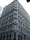
[3] Name on the Register Image Date listed [4] Location Neighborhood Description 1 75 Murray Street Building 75 Murray Street Building April 3, 1973 (# 73001213 75 Murray St. 40°42′53″N 74°00′40″W / 40.714722°N 74.011111°W / 40.714722; -74.011111 (75 Murray Street Building ) Tribeca One of the earliest cast iron façades; created by James Bogardus; built in 1858 2 ADMIRAL DEWEY (tugboat) ADMIRAL DEWEY (tugboat) December 27, 2002 (# 02001619 Pier 16, East River 40°42′19″N 74°00′11″W / 40.705278°N 74.003056°W / 40.705278; -74.003056 (ADMIRAL DEWEY (tugboat) South Street Seaport 3 African Burying Ground African Burying Ground April 19, 1993 (# 93001597 Vicinity of Broadway and Reade St. 40°42′49″N 73°59′38″W / 40.713611°N 73.993889°W / 40.713611; -73.993889 (African Burying Ground ) Civic Center Site containing the remains of over 419 Africans buried from 1690s to 1794. 4 AMBROSE (lightship) AMBROSE (lightship) September 7, 1984 (# 84002758 Pier 16, East River, Manhattan 40°42′17″N 74°00′09″W / 40.704722°N 74.0025°W / 40.704722; -74.0025 (AMBROSE (lightship) South Street Seaport Beacon for New York Harbor, 1908-1933; now at South Street Seaport Museum 5 American Bank Note Company Building American Bank Note Company Building November 30, 1999 (# 99001436 70 Broad St. 40°42′17″N 74°00′45″W / 40.704722°N 74.0125°W / 40.704722; -74.0125 (American Bank Note Company Building ) Financial District 1908 home of American Bank Note Company , engravers. Now owned by Global Financial Capital of New York, founded by the Maharishi Mahesh Yogi . 6 American Stock Exchange American Stock Exchange June 2, 1978 (# 78001867 86 Trinity Pl. 40°42′30″N 74°00′48″W / 40.708333°N 74.013333°W / 40.708333; -74.013333 (American Stock Exchange ) Financial District Built in 1921; former headquarters of the American Stock Exchange 7 American Thread Building American Thread Building January 20, 2005 (# 04001532 260 West Broadway 40°43′14″N 74°00′22″W / 40.720556°N 74.006111°W / 40.720556; -74.006111 (American Thread Building ) Tribeca 8 Astor Place Subway Station (IRT) Astor Place Subway Station (IRT) September 17, 2004 (# 04001013 Junction of Bowery, Astor Place and Lafayette St. 40°43′48″N 73°59′30″W / 40.73°N 73.991667°W / 40.73; -73.991667 (Astor Place Subway Station (IRT) ) East Village Subway station ( 4 , 6 , and < 6> 9 Bank of New York Building Bank of New York Building August 28, 2003 (# 03000847 48 Wall St. 40°42′23″N 74°00′34″W / 40.706389°N 74.009444°W / 40.706389; -74.009444 (Bank of New York Building ) Financial District Built in 1928; land used by the bank since 1797; modified to house the Museum of American Finance 10 Battery Park Control House Battery Park Control House May 6, 1980 (# 80002669 State St. and Battery Pl. 40°42′14″N 74°00′54″W / 40.703889°N 74.015°W / 40.703889; -74.015 (Battery Park Control House ) Financial District Subway control house for the 4 5 Control house " refers to controlling the passenger flow 11 Bayard-Condict Building Bayard-Condict Building December 8, 1976 (# 76001236 65–69 Bleecker St. 40°43′35″N 73°59′43″W / 40.726389°N 73.995278°W / 40.726389; -73.995278 (Bayard-Condict Building ) Greenwich Village Only work of architect Louis Sullivan in New York City; built between 1897 and 1899; Chicago school style 12 Beaver Building Beaver Building July 6, 2005 (# 05000668 82–92 Beaver St. 40°42′18″N 74°00′32″W / 40.705°N 74.008889°W / 40.705; -74.008889 (Beaver Building ) Financial District Triangular-shaped building; designed by Clinton and Russell; completed in 1904 13 Bell Telephone Laboratories Bell Telephone Laboratories May 15, 1975 (# 75001202 463 West St. 40°44′12″N 74°00′35″W / 40.736667°N 74.009722°W / 40.736667; -74.009722 (Bell Telephone Laboratories ) West Village 13 building complex; home of Bell Telephone Laboratories between 1898 and 1966. See also Westbeth , which is for the same buildings but a different reason. 14 Beth Hamedrash Hagodol Synagogue Beth Hamedrash Hagodol Synagogue November 30, 1999 (# 99001438 60–64 Norfolk St. 40°43′01″N 73°59′18″W / 40.716944°N 73.988333°W / 40.716944; -73.988333 (Beth Hamedrash Hagodol Synagogue ) Lower East Side Orthodox synagogue; oldest Orthodox Russian Jewish congregation in the United States; Gothic Revival structure; 1850 15 Bialystoker Synagogue Bialystoker Synagogue April 26, 1972 (# 72000861 7–13 Willett St. 40°42′56″N 73°59′01″W / 40.715556°N 73.983611°W / 40.715556; -73.983611 (Bialystoker Synagogue ) Lower East Side Fieldstone building; built in 1826; late Federal style architecture; originally Methodist Episcopal Church; now an Orthodox Jewish synagogue 16 Bleecker Street Subway Station (IRT) Bleecker Street Subway Station (IRT) September 17, 2004 (# 04001012 Junction of Bleecker and Lafayette Sts. 40°43′35″N 73°59′43″W / 40.726389°N 73.995278°W / 40.726389; -73.995278 (Bleecker Street Subway Station (IRT) ) Greenwich Village Subway station ( 4 , 6 , and < 6> IRT subway by the Grueby Faience Company in 1904 17 Bouwerie Lane Theater Bouwerie Lane Theater April 23, 1980 (# 80002671 330 Bowery 40°43′32″N 73°59′11″W / 40.725556°N 73.986389°W / 40.725556; -73.986389 (Bouwerie Lane Theater ) NoHo Designed by Henry Engelbert; constructed from 1873-74; originally the Bond Street Savings Bank; cast iron building; French Second Empire style; converted to a theater in 1963 18 The Bowery Historic District The Bowery Historic District February 20, 2013 (# 13000027 Bowery between Chatham Square and Cooper Square 40°43′17″N 73°59′37″W / 40.721404°N 73.993614°W / 40.721404; -73.993614 (The Bowery Historic District ) The Bowery One of the most architecturally diverse and historically significant streetscapes in the city; first residence for many immigrant groups. 19 Bowery Savings Bank Bowery Savings Bank April 23, 1980 (# 80002672 130 Bowery St. 40°43′08″N 73°59′44″W / 40.7188°N 73.9955°W / 40.7188; -73.9955 (Bowery Savings Bank ) The Bowery First headquarters of the Bowery Savings Bank; designed by Stanford White; built in 1893 20 Bowling Green Fence and Park Bowling Green Fence and Park April 9, 1980 (# 80002673 Broadway and Beaver Sts. 40°42′18″N 74°00′51″W / 40.705°N 74.014167°W / 40.705; -74.014167 (Bowling Green Fence and Park ) South Ferry Small public park in Lower Manhattan; oldest existing public park in New York City; origin point for ticker-tape parades 21 Broad Exchange Building Broad Exchange Building April 13, 1998 (# 98000366 25 Broad St. 40°42′21″N 74°00′41″W / 40.705833°N 74.011389°W / 40.705833; -74.011389 (Broad Exchange Building ) Financial District 1902 building was the largest office building in the Financial District. It is now a luxury residential building. 22 Brooklyn Bridge Brooklyn Bridge October 15, 1966 (# 66000523 Across the East River from Brooklyn to Manhattan 40°42′23″N 73°59′51″W / 40.706389°N 73.9975°W / 40.706389; -73.9975 (Brooklyn Bridge ) Civic Center One of the oldest suspension bridges in the United States; 5,989 feet (1825 m) long; iconic part of the New York skyline 23 Brooklyn Bridge-City Hall Subway Station (IRT) Brooklyn Bridge-City Hall Subway Station (IRT) July 6, 2005 (# 05000674 Under Centre St. bet. Chambers and Frankfort Sts. 40°42′47″N 74°00′16″W / 40.713056°N 74.004444°W / 40.713056; -74.004444 (Brooklyn Bridge-City Hall Subway Station (IRT) ) Civic Center Subway station ( 4 , 5 , 6 , and < 6> 24 James Brown House James Brown House August 11, 1983 (# 83001717 326 Spring St. 40°43′33″N 74°00′35″W / 40.725833°N 74.009722°W / 40.725833; -74.009722 (James Brown House ) Hudson Square Rare example of Federal architecture in New York; built before 1812; home of James Brown, Revolutionary War veteran; site of one of the oldest bars in the City 25 Building at 19 Rector St. Building at 19 Rector St. May 22, 2002 (# 02000551 19 Rector St., 88 Greenwich St. 40°42′28″N 74°00′52″W / 40.707778°N 74.014444°W / 40.707778; -74.014444 (Building at 19 Rector St. ) Financial District 26 Building at 21 West Street Building at 21 West Street March 12, 1999 (# 99000316 21 West St. 40°42′22″N 74°00′57″W / 40.706111°N 74.015833°W / 40.706111; -74.015833 (Building at 21 West Street ) Financial District 27 Building at 116 John Street Building at 116 John Street June 20, 2014 (# 14000331 116 John St. 40°42′27″N 74°00′22″W / 40.707500°N 74.006111°W / 40.707500; -74.006111 (Building at 116 John Street ) Financial District Art Deco building from early 1930s is one of the last skyscrapers erected during 1920s building boom. Converted into apartments in 2010s. 28 Building at 287 Broadway Building at 287 Broadway February 20, 2024 (# 100009933 287 Broadway 40°42′53″N 74°00′21″W / 40.714751°N 74.005741°W / 40.714751; -74.005741 (Building at 287 Broadway ) Tribeca 29 Building at 254–260 Canal Street Building at 254–260 Canal Street June 7, 2006 (# 06000475 254–260 Canal St. 40°43′06″N 74°00′05″W / 40.718333°N 74.00139°W / 40.718333; -74.00139 (Building at 254–260 Canal Street ) Chinatown 30 Building at 376–380 Lafayette Street Building at 376–380 Lafayette Street December 28, 1979 (# 79001600 376–380 Lafayette Street 40°43′38″N 73°59′41″W / 40.727222°N 73.994722°W / 40.727222; -73.994722 (Building at 376–380 Lafayette Street ) NoHo 31 Building at 361 Broadway Building at 361 Broadway September 15, 1983 (# 83001718 361 Broadway 40°43′02″N 74°00′15″W / 40.717222°N 74.004167°W / 40.717222; -74.004167 (Building at 361 Broadway ) Tribeca 32 Building at 85 Leonard Street Building at 85 Leonard Street April 23, 1980 (# 80002675 85 Leonard St. 40°43′03″N 74°00′19″W / 40.7175°N 74.005278°W / 40.7175; -74.005278 (Building at 85 Leonard Street ) Tribeca 33 Building at 821 Broadway Upload image May 10, 2024 (# 100010272 821 Broadway 40°44′00″N 73°59′28″W / 40.7334°N 73.9912°W / 40.7334; -73.9912 (Building at 821 Broadway ) 34 Caffe Cino Upload image November 9, 2017 (# 100001802 31 Cornelia St. 40°43′53″N 74°00′08″W / 40.73144°N 74.00228°W / 40.73144; -74.00228 (Caffe Cino ) West Village Café recognized as the birthplace of off-off-Broadway theatre, and for pioneering gay theatre in early 1970s. 35 Cary Building Cary Building September 15, 1983 (# 83001719 105–107 Chambers St. 40°42′55″N 74°00′30″W / 40.715278°N 74.008333°W / 40.715278; -74.008333 (Cary Building ) Tribeca 36 Castle Clinton National Monument Castle Clinton National Monument October 15, 1966 (# 66000537 South Ferry 40°42′12″N 74°01′01″W / 40.703333°N 74.016944°W / 40.703333; -74.016944 (Castle Clinton National Monument ) Battery Park 37 Chamber of Commerce Chamber of Commerce February 6, 1973 (# 73001214 65 Liberty St. 40°42′32″N 74°00′36″W / 40.708889°N 74.01°W / 40.708889; -74.01 (Chamber of Commerce ) Financial District 38 Chambers Street Subway Station (Dual System BMT) Chambers Street Subway Station (Dual System BMT) July 6, 2005 (# 05000669 Beneath the Municipal Building at Chambers, Centre and Duane Sts. and Lafayette Plaza 40°42′47″N 74°00′14″W / 40.713056°N 74.003889°W / 40.713056; -74.003889 (Chambers Street Subway Station (Dual System BMT) ) Civic Center Subway station ( J Z 39 Chambers Street Subway Station (Dual System IRT) Chambers Street Subway Station (Dual System IRT) March 30, 2005 (# 05000234 Under West Broadway bet Warren, Chambers and Reade Sts. 40°42′56″N 74°00′35″W / 40.715556°N 74.009722°W / 40.715556; -74.009722 (Chambers Street Subway Station (Dual System IRT) ) Financial District , and Tribeca Subway station ( 1 , 2 , and 3 40 Charles Street House at No. 131 Charles Street House at No. 131 November 3, 1972 (# 72000866 131 Charles St. 40°44′04″N 74°00′28″W / 40.734444°N 74.007778°W / 40.734444; -74.007778 (Charles Street House at No. 131 ) West Village 41 Charlton-King-Vandam Historic District Charlton-King-Vandam Historic District July 20, 1973 (# 73001215 Roughly bounded by Varick, Vandam, MacDougal and King Sts. 40°43′38″N 74°00′15″W / 40.727222°N 74.004167°W / 40.727222; -74.004167 (Charlton-King-Vandam Historic District ) South Village 42 Chinatown and Little Italy Historic District Chinatown and Little Italy Historic District February 12, 2010 (# 10000012 Roughly bounded by Baxter St., Centre St., Cleveland Pl. and Lafayette St. to the W; Jersey St. and E. Houston 40°43′11″N 73°59′55″W / 40.7198°N 73.998556°W / 40.7198; -73.998556 (Chinatown and Little Italy Historic District ) Chinatown and Little Italy Chinatown and Little Italy are two of the city's most significant ethnic enclaves 43 Christodora House Christodora House March 20, 1986 (# 86000486 147 Ave. B 40°43′35″N 73°58′50″W / 40.726389°N 73.980556°W / 40.726389; -73.980556 (Christodora House ) East Village and Alphabet City Apex of idealistic settlement movement in New York 44 Church of the Ascension (Protestant Episcopal) Church of the Ascension (Protestant Episcopal) December 23, 1987 (# 87002593 36–38 Fifth Ave. 40°44′01″N 73°59′46″W / 40.733611°N 73.996111°W / 40.733611; -73.996111 (Church of the Ascension (Protestant Episcopal) ) Greenwich Village 45 Church of the Transfiguration Church of the Transfiguration April 16, 1980 (# 80002682 25 Mott St. 40°42′53″N 73°59′57″W / 40.714722°N 73.999167°W / 40.714722; -73.999167 (Church of the Transfiguration ) Chinatown 46 City Hall City Hall October 15, 1966 (# 66000539 Broadway and Chambers St. 40°42′48″N 74°00′20″W / 40.713397°N 74.005553°W / 40.713397; -74.005553 (City Hall ) Civic Center 47 City Hall Subway Station (IRT) City Hall Subway Station (IRT) September 17, 2004 (# 04001010 Park Row and City Hall Park 40°42′42″N 74°00′26″W / 40.711667°N 74.007222°W / 40.711667; -74.007222 (City Hall Subway Station (IRT) ) Civic Center Subway station (closed ) 48 City Pier A City Pier A June 27, 1975 (# 75001203 S end of Battery Pl. at Hudson River 40°42′15″N 74°01′06″W / 40.704167°N 74.018333°W / 40.704167; -74.018333 (City Pier A ) Battery Park 49 Cooper Union Cooper Union October 15, 1966 (# 66000540 Cooper Square, 7th St., and 4th Ave. 40°43′45″N 73°59′27″W / 40.729167°N 73.990833°W / 40.729167; -73.990833 (Cooper Union ) East Village 50 Corbin Building Corbin Building December 18, 2003 (# 03001302 192 Broadway 40°42′36″N 74°00′34″W / 40.710000°N 74.009444°W / 40.710000; -74.009444 (Corbin Building ) Financial District 51 Devinne Press Building Devinne Press Building September 14, 1977 (# 77000955 393–399 Lafayette St. 40°43′40″N 73°59′36″W / 40.727778°N 73.993333°W / 40.727778; -73.993333 (Devinne Press Building ) NoHo 52 Eldridge Street Synagogue Eldridge Street Synagogue March 28, 1980 (# 80002687 12–16 Eldridge St. 40°42′53″N 73°59′39″W / 40.714722°N 73.994167°W / 40.714722; -73.994167 (Eldridge Street Synagogue ) Chinatown 53 Eleventh Street Methodist Episcopal Church Eleventh Street Methodist Episcopal Church December 30, 2011 (# 11000968 543–547 E. 11th St. 40°43′40″N 73°58′47″W / 40.727642°N 73.979839°W / 40.727642; -73.979839 (Eleventh Street Methodist Episcopal Church ) East Village 54 Empire Building Empire Building August 28, 1998 (# 83004643 71 Broadway 40°42′26″N 74°00′47″W / 40.707222°N 74.013056°W / 40.707222; -74.013056 (Empire Building ) Financial District 55 Equitable Building Equitable Building June 2, 1978 (# 78001869 120 Broadway 40°42′29″N 74°00′39″W / 40.708056°N 74.010833°W / 40.708056; -74.010833 (Equitable Building ) Financial District 56 Federal Hall National Memorial Federal Hall National Memorial October 15, 1966 (# 66000095 Wall and Nassau Sts. 40°42′26″N 74°00′38″W / 40.707222°N 74.010556°W / 40.707222; -74.010556 (Federal Hall National Memorial ) Financial District 57 Federal Office Building Federal Office Building August 30, 1974 (# 74001267 641 Washington St. 40°43′56″N 74°00′31″W / 40.732222°N 74.008611°W / 40.732222; -74.008611 (Federal Office Building ) Greenwich Village 58 Federal Reserve Bank of New York Federal Reserve Bank of New York May 6, 1980 (# 80002688 33 Liberty St. 40°42′33″N 74°00′36″W / 40.709167°N 74.01°W / 40.709167; -74.01 (Federal Reserve Bank of New York ) Financial District 59 Firehouse, Engine Company 31 Firehouse, Engine Company 31 January 20, 1972 (# 72000870 87 Lafayette St. 40°43′02″N 74°00′05″W / 40.717222°N 74.001389°W / 40.717222; -74.001389 (Firehouse, Engine Company 31 ) Civic Center 60 Firehouse, Engine Company 33 Firehouse, Engine Company 33 March 16, 1972 (# 72000871 44 Great Jones St. 40°43′37″N 73°59′35″W / 40.726944°N 73.993056°W / 40.726944; -73.993056 (Firehouse, Engine Company 33 ) NoHo 61 First Houses First Houses December 18, 1979 (# 79001602 E. 3rd St. and Ave. A 40°43′25″N 73°59′09″W / 40.723611°N 73.985833°W / 40.723611; -73.985833 (First Houses ) East Village 62 First National City Bank First National City Bank August 18, 1972 (# 72000872 55 Wall St. 40°42′22″N 74°00′36″W / 40.706111°N 74.01°W / 40.706111; -74.01 (First National City Bank ) Financial District 63 First Police Precinct Station House First Police Precinct Station House October 29, 1982 (# 82001193 South St. and Old Slip 40°42′12″N 74°00′29″W / 40.7034°N 74.0080°W / 40.7034; -74.0080 (First Police Precinct Station House ) Financial District 64 First Romanian-American Congregation Synagogue First Romanian-American Congregation Synagogue March 12, 1998 (# 98000239 89–93 Rivington St. 40°43′12″N 73°59′21″W / 40.72°N 73.9892°W / 40.72; -73.9892 (First Romanian-American Congregation Synagogue ) Lower East Side 65 First Shearith Israel Graveyard First Shearith Israel Graveyard April 17, 1980 (# 80002689 55–57 St. James Pl. 40°42′46″N 73°59′56″W / 40.7128°N 73.9989°W / 40.7128; -73.9989 (First Shearith Israel Graveyard ) Lower East Side 66 Hamilton Fish House Hamilton Fish House July 31, 1972 (# 72001456 21 Stuyvesant St. 40°43′49″N 73°59′20″W / 40.7303°N 73.9889°W / 40.7303; -73.9889 (Hamilton Fish House ) East Village 67 Former Emigrant Industrial Savings Bank Former Emigrant Industrial Savings Bank February 25, 1982 (# 82003375 51 Chambers St. 40°42′50″N 74°00′19″W / 40.7139°N 74.0053°W / 40.7139; -74.0053 (Former Emigrant Industrial Savings Bank ) Civic Center 68 Former New York Life Insurance Company Building Former New York Life Insurance Company Building June 28, 1982 (# 82003376 346 Broadway 40°42′58″N 74°00′13″W / 40.7161°N 74.0036°W / 40.7161; -74.0036 (Former New York Life Insurance Company Building ) Civic Center 69 Former Police Headquarters Building Former Police Headquarters Building March 28, 1980 (# 80002690 240 Centre St. 40°43′12″N 73°59′56″W / 40.72°N 73.9989°W / 40.72; -73.9989 (Former Police Headquarters Building ) Little Italy 70 Fourteenth Ward Industrial School Fourteenth Ward Industrial School January 27, 1983 (# 83001724 256–258 Mott St. 40°43′25″N 73°59′41″W / 40.7236°N 73.9947°W / 40.7236; -73.9947 (Fourteenth Ward Industrial School ) Nolita 71 Fraunces Tavern Block Fraunces Tavern Block April 28, 1977 (# 77000957 Bounded by Pearl, Water, Broad Sts. and Coenties Slip 40°42′12″N 74°00′41″W / 40.7033°N 74.0114°W / 40.7033; -74.0114 (Fraunces Tavern Block ) Financial District 72 Fraunces Tavern Fraunces Tavern March 6, 2008 (# 08000140 54 Pearl Street 40°42′13″N 74°00′41″W / 40.7035°N 74.0115°W / 40.7035; -74.0115 (Fraunces Tavern ) Financial District 73 Fulton-Nassau Historic District Fulton-Nassau Historic District September 7, 2005 (# 05000988 Roughly bounded by Broadway and Park Row, Nassau, Dutch and William Sts, Ann and Spruce Sts. and Liberty St. 40°42′37″N 74°00′29″W / 40.7103°N 74.0081°W / 40.7103; -74.0081 (Fulton-Nassau Historic District ) Lower Manhattan 74 Gansevoort Market Historic District Gansevoort Market Historic District May 30, 2007 (# 07000487 Roughly bounded by W 16th St., Ninth Ave., and Hudson St., Gansevoort St.; West St. and Eleventh Ave. 40°44′28″N 74°00′27″W / 40.7410°N 74.0076°W / 40.7410; -74.0076 (Gansevoort Market Historic District ) Meatpacking District 75 German Evangelical Lutheran Church of St. Mark German Evangelical Lutheran Church of St. Mark April 15, 2004 (# 04000296 323 E. 6th St. 40°43′37″N 73°59′15″W / 40.7269°N 73.9875°W / 40.7269; -73.9875 (German Evangelical Lutheran Church of St. Mark ) East Village 76 Gouverneur Hospital Gouverneur Hospital October 29, 1982 (# 82001194 621 Water St. 40°42′39″N 73°59′05″W / 40.7108°N 73.9847°W / 40.7108; -73.9847 (Gouverneur Hospital ) Lower East Side 77 Grace Church and Dependencies Grace Church and Dependencies June 28, 1974 (# 74001270 Broadway, 10th St., and 4th Ave. 40°43′55″N 73°59′28″W / 40.7319°N 73.9911°W / 40.7319; -73.9911 (Grace Church and Dependencies ) Greenwich Village 78 Greenwich Village Historic District Greenwich Village Historic District June 19, 1979 (# 79001604 Roughly bounded by W. 13th St., St. Luke's Pl., University Pl., and Washington St. 40°44′02″N 74°00′04″W / 40.7339°N 74.0011°W / 40.7339; -74.0011 (Greenwich Village Historic District ) Greenwich Village 79 Lorraine Hansberry House Lorraine Hansberry House April 22, 2021 (# 100006490 337 Bleecker St. 40°44′01″N 74°00′15″W / 40.7337°N 74.0043°W / 40.7337; -74.0043 (Lorraine Hansberry House ) West Village 80 E. V. Haughwout Building E. V. Haughwout Building August 28, 1973 (# 73001218 488–492 Broadway 40°43′24″N 74°00′10″W / 40.7233°N 74.0028°W / 40.7233; -74.0028 (E. V. Haughwout Building ) SoHo Home of the world's first successful passenger elevator , a hydraulic lift designed for the building by Elisha Graves Otis 81 Henry Street Settlement and Neighborhood Playhouse Henry Street Settlement and Neighborhood Playhouse September 13, 1974 (# 74001272 263–267 Henry St. and 466 Grand St. 40°42′50″N 73°59′07″W / 40.7139°N 73.9853°W / 40.7139; -73.9853 (Henry Street Settlement and Neighborhood Playhouse ) Lower East Side 82 Holland Tunnel Holland Tunnel November 4, 1993 (# 93001619 Connecting Lower Manhattan and Jersey City, running under the Hudson R. 40°43′38″N 74°00′41″W / 40.7272°N 74.0114°W / 40.7272; -74.0114 (Holland Tunnel ) Tribeca and Hudson Square 83 Hotel Albert Hotel Albert June 13, 2012 (# 12000329 23 E. 10th St. 40°43′58″N 73°59′37″W / 40.7327°N 73.9936°W / 40.7327; -73.9936 (Hotel Albert ) Greenwich Village 84 Houses at 26, 28 and 30 Jones Street Houses at 26, 28 and 30 Jones Street June 3, 1982 (# 82003379 26, 28 and 30 Jones St. 40°43′53″N 74°00′10″W / 40.731389°N 74.002778°W / 40.731389; -74.002778 (Houses at 26, 28 and 30 Jones Street ) Greenwich Village 85 Isaac T. Hopper House Isaac T. Hopper House May 22, 1986 (# 86001155 110 Second Ave. 40°43′39″N 73°59′19″W / 40.7275°N 73.988611°W / 40.7275; -73.988611 (Isaac T. Hopper House ) East Village 86 House at 203 Prince Street House at 203 Prince Street May 26, 1983 (# 83001731 203 Prince St. 40°43′37″N 74°00′12″W / 40.726944°N 74.003333°W / 40.726944; -74.003333 (House at 203 Prince Street ) SoHo 87 House at 37 East 4th Street House at 37 East 4th Street January 3, 1980 (# 80002695 37 E. 4th St. 40°43′39″N 73°59′32″W / 40.7275°N 73.992222°W / 40.7275; -73.992222 (House at 37 East 4th Street ) NoHo House of Samuel Tredwell Skidmore 88 House at 51 Market Street House at 51 Market Street July 29, 1977 (# 77000959 51 Market St. 40°42′42″N 73°59′42″W / 40.711667°N 73.995°W / 40.711667; -73.995 (House at 51 Market Street ) Two Bridges 89 Houses at 83 and 85 Sullivan Street Houses at 83 and 85 Sullivan Street November 17, 1980 (# 80002696 83–85 Sullivan St. 40°43′29″N 74°00′14″W / 40.724722°N 74.003889°W / 40.724722; -74.003889 (Houses at 83 and 85 Sullivan Street ) SoHo 90 Insurance Company of North America Building Insurance Company of North America Building November 30, 1999 (# 99001425 99 John St. 40°42′30″N 74°00′23″W / 40.708333°N 74.006389°W / 40.708333; -74.006389 (Insurance Company of North America Building ) Financial District 91 International Mercantile Marine Company Building International Mercantile Marine Company Building March 2, 1991 (# 91000108 1 Broadway 40°42′17″N 74°00′54″W / 40.704722°N 74.015°W / 40.704722; -74.015 (International Mercantile Marine Company Building ) Financial District 92 J. P. Morgan & Co. Building J. P. Morgan & Co. Building June 19, 1972 (# 72000874 23 Wall St. 40°42′27″N 74°00′42″W / 40.7075°N 74.011667°W / 40.7075; -74.011667 (J. P. Morgan & Co. Building ) Financial District 93 JOHN A. LYNCH (ferryboat) JOHN A. LYNCH (ferryboat) September 7, 1984 (# 84002775 Pier 15, East River, Manhattan 40°42′18″N 74°00′08″W / 40.705°N 74.002222°W / 40.705; -74.002222 (JOHN A. LYNCH (ferryboat) South Street Seaport No longer docked at Pier 15. Now half submerged at 40°33′38″N 74°13′56″W / 40.560532°N 74.232159°W / 40.560532; -74.232159 94 John Street Building No. 170–176 John Street Building No. 170–176 May 13, 1971 (# 71000546 170–176 John St. 40°42′21″N 74°00′17″W / 40.705833°N 74.004722°W / 40.705833; -74.004722 (John Street Building No. 170–176 ) Financial District 95 John Street Methodist Church John Street Methodist Church June 4, 1973 (# 73001219 44 John St. 40°42′33″N 74°00′31″W / 40.709167°N 74.008611°W / 40.709167; -74.008611 (John Street Methodist Church ) Financial District 96 Joralemon Street Tunnel Joralemon Street Tunnel February 9, 2006 (# 06000015 Tunnel beneath East River from Bowling Green (State St.) to Joralemon St. and Willow Place 40°41′53″N 74°00′27″W / 40.698056°N 74.0075°W / 40.698056; -74.0075 (Joralemon Street Tunnel ) Bowling Green Subway tunnel for the 4 5 97 Judson Memorial Church, Campanile, and Judson Hall Judson Memorial Church, Campanile, and Judson Hall October 16, 1974 (# 74001274 Washington Sq. at Thompson St. 40°43′50″N 73°59′51″W / 40.730556°N 73.9975°W / 40.730556; -73.9975 (Judson Memorial Church, Campanile, and Judson Hall ) Greenwich Village 98 Julius' Bar Julius' Bar April 20, 2016 (# 16000242 188 Waverly Place 40°44′04″N 74°00′06″W / 40.73454°N 74.00158°W / 40.73454; -74.00158 (Julius' Bar ) West Village Often described as New York's oldest continuously operating gay bar . Site of 1966 protest that allowed it to operate as one. 99 Kehila Kedosha Janina Synagogue Kehila Kedosha Janina Synagogue November 30, 1999 (# 99001430 280 Broome St. 40°43′07″N 73°59′30″W / 40.718611°N 73.991667°W / 40.718611; -73.991667 (Kehila Kedosha Janina Synagogue ) Lower East Side 100 LaGrange Terrace LaGrange Terrace December 12, 1976 (# 76001242 428–434 Lafayette St. 40°43′46″N 73°59′34″W / 40.729444°N 73.992778°W / 40.729444; -73.992778 (LaGrange Terrace ) NoHo Known also as Colonnade Row 101 Lee, Higginson & Company Bank Building Lee, Higginson & Company Bank Building June 7, 2006 (# 06000476 41 Broad St. 40°42′20″N 74°00′41″W / 40.705556°N 74.011389°W / 40.705556; -74.011389 (Lee, Higginson & Company Bank Building ) Financial District 102 Daniel LeRoy House Daniel LeRoy House October 29, 1982 (# 82001200 20 St. Mark's Pl. 40°43′43″N 73°59′20″W / 40.728611°N 73.988889°W / 40.728611; -73.988889 (Daniel LeRoy House ) East Village 103 LETTIE G. HOWARD (schooner) LETTIE G. HOWARD (schooner) September 7, 1984 (# 84002779 South Street Seaport Museum 40°42′17″N 74°00′15″W / 40.704722°N 74.004167°W / 40.704722; -74.004167 (LETTIE G. HOWARD (schooner) South Street Seaport 104 Liberty Tower Liberty Tower September 15, 1983 (# 83001734 55 Liberty St. 40°42′31″N 74°00′35″W / 40.708611°N 74.009722°W / 40.708611; -74.009722 (Liberty Tower ) Financial District 105 LILAC , United States Lighthouse Tender LILAC , United States Lighthouse Tender January 7, 2005 (# 04001441 Pier 40 40°43′58″N 74°00′46″W / 40.732778°N 74.012778°W / 40.732778; -74.012778 (LILAC , United States Lighthouse Tender Greenwich Village 106 Lower East Side Historic District Lower East Side Historic District September 7, 2000 (# 00001015 Roughly bounded by Allen St., E. Houston, Essex St., Canal St., Eldridge St., E. Broadway, and Grand St. 40°43′02″N 73°59′23″W / 40.717222°N 73.989722°W / 40.717222; -73.989722 (Lower East Side Historic District ) Lower East Side 107 MacDougal-Sullivan Gardens Historic District MacDougal-Sullivan Gardens Historic District June 30, 1983 (# 83001736 74–76 MacDougal St., 170–188 Sullivan St. 40°43′42″N 74°00′10″W / 40.728333°N 74.002778°W / 40.728333; -74.002778 (MacDougal-Sullivan Gardens Historic District ) South Village 108 MACHIGONNE (ferry) MACHIGONNE (ferry) December 3, 1992 (# 92001610 Pier 25 40°43′18″N 74°00′57″W / 40.721667°N 74.015833°W / 40.721667; -74.015833 (MACHIGONNE (ferry) TriBeCa 109 Macmillan Building Macmillan Building November 1, 2006 (# 06000973 60–62 Fifth Ave. 40°44′06″N 73°59′43″W / 40.735°N 73.995278°W / 40.735; -73.995278 (Macmillan Building ) Greenwich Village Now used by Forbes Magazine 110 Manhattan Bridge Manhattan Bridge August 30, 1983 (# 83001694 Spans East River between Front and Canal St. 40°42′36″N 73°59′18″W / 40.71°N 73.988333°W / 40.71; -73.988333 (Manhattan Bridge ) Two Bridges 111 Manhattan Company Building Manhattan Company Building June 16, 2000 (# 00000577 40 Wall St. 40°42′25″N 74°00′36″W / 40.706944°N 74.01°W / 40.706944; -74.01 (Manhattan Company Building ) Financial District 112 Mariner's Temple Mariner's Temple April 16, 1980 (# 80002700 12 Oliver St. 40°42′46″N 73°59′54″W / 40.712778°N 73.998333°W / 40.712778; -73.998333 (Mariner's Temple ) Two Bridges 113 Metropolitan Savings Bank Building Metropolitan Savings Bank Building December 12, 1976 (# 76001243 9 E. 7th St. 40°43′44″N 73°59′26″W / 40.728889°N 73.990556°W / 40.728889; -73.990556 (Metropolitan Savings Bank Building ) East Village 114 Edward Mooney House Edward Mooney House December 12, 1976 (# 76001245 18 Bowery 40°42′52″N 73°59′53″W / 40.714444°N 73.998056°W / 40.714444; -73.998056 (Edward Mooney House ) Chinatown 115 Municipal Building Municipal Building October 18, 1972 (# 72000879 Chambers at Centre St. 40°42′47″N 74°00′14″W / 40.713056°N 74.003889°W / 40.713056; -74.003889 (Municipal Building ) Civic Center 116 Municipal Ferry Pier Municipal Ferry Pier December 12, 1976 (# 76001246 11 South St. 40°42′03″N 74°00′43″W / 40.700833°N 74.011944°W / 40.700833; -74.011944 (Municipal Ferry Pier ) South Ferry 117 National City Bank National City Bank June 2, 1978 (# 78001875 55 Wall St. 40°42′21″N 74°00′35″W / 40.705833°N 74.009722°W / 40.705833; -74.009722 (National City Bank ) Financial District 118 New York City Marble Cemetery New York City Marble Cemetery September 17, 1980 (# 80002703 52–74 E. 2nd St. 40°43′28″N 73°59′23″W / 40.724444°N 73.989722°W / 40.724444; -73.989722 (New York City Marble Cemetery ) East Village 119 New York Cotton Exchange New York Cotton Exchange January 7, 1972 (# 72001586 1 Hanover Sq. 40°42′16″N 74°00′37″W / 40.704444°N 74.010278°W / 40.704444; -74.010278 (New York Cotton Exchange ) Financial District 120 New York County Lawyers Association Building New York County Lawyers Association Building October 29, 1982 (# 82001201 14 Vesey St. 40°42′43″N 74°00′35″W / 40.711944°N 74.009722°W / 40.711944; -74.009722 (New York County Lawyers Association Building ) Financial District 121 New York Evening Post Building New York Evening Post Building September 22, 2000 (# 00001160 75 West St. 40°42′32″N 74°00′54″W / 40.708889°N 74.015°W / 40.708889; -74.015 (New York Evening Post Building ) Financial District 122 New York Marble Cemetery New York Marble Cemetery September 17, 1980 (# 80004475 Between East 2nd and 3rd Sts.,2nd Ave. and Bowery 40°44′04″N 73°59′29″W / 40.734444°N 73.991389°W / 40.734444; -73.991389 (New York Marble Cemetery ) East Village 123 New York Shakespeare Festival Public Theater New York Shakespeare Festival Public Theater December 2, 1970 (# 70000424 425 Lafayette St. 40°43′41″N 73°59′33″W / 40.728056°N 73.9925°W / 40.728056; -73.9925 (New York Shakespeare Festival Public Theater ) NoHo 124 New York Stock Exchange New York Stock Exchange June 2, 1978 (# 78001877 11 Wall St. 40°42′24″N 74°00′42″W / 40.706667°N 74.011667°W / 40.706667; -74.011667 (New York Stock Exchange ) Financial District 125 New York Studio School of Drawing, Painting and Sculpture New York Studio School of Drawing, Painting and Sculpture April 27, 1992 (# 92001877 8–14 W. 8th St. 40°43′57″N 73°59′53″W / 40.7325°N 73.998056°W / 40.7325; -73.998056 (New York Studio School of Drawing, Painting and Sculpture ) Greenwich Village 126 New York Telephone Company Building New York Telephone Company Building April 30, 2009 (# 09000257 140 West St. 40°42′50″N 74°00′47″W / 40.713753°N 74.012917°W / 40.713753; -74.012917 (New York Telephone Company Building ) Tribeca 127 No. 8 Thomas Street Building No. 8 Thomas Street Building April 30, 1980 (# 80002705 8 Thomas St. 40°42′57″N 74°00′22″W / 40.715833°N 74.006111°W / 40.715833; -74.006111 (No. 8 Thomas Street Building ) Lower Manhattan 128 Odd Fellows Hall Odd Fellows Hall September 22, 1983 (# 83001737 165–171 Grand St. 40°43′11″N 73°59′53″W / 40.719722°N 73.998056°W / 40.719722; -73.998056 (Odd Fellows Hall ) Little Italy 129 Old Merchant's House Old Merchant's House October 15, 1966 (# 66000548 29 E. 4th St. 40°43′40″N 73°59′33″W / 40.727778°N 73.9925°W / 40.727778; -73.9925 (Old Merchant's House ) Lower Manhattan Known also as Merchant's House Museum 130 Old New York Evening Post Building Old New York Evening Post Building August 16, 1977 (# 77000963 20 Vesey St. 40°42′43″N 74°00′36″W / 40.711944°N 74.01°W / 40.711944; -74.01 (Old New York Evening Post Building ) Financial District 131 Old St. Patrick's Cathedral Complex Old St. Patrick's Cathedral Complex August 29, 1977 (# 77000964 Mott and Prince Sts. 40°43′25″N 73°59′44″W / 40.723611°N 73.995556°W / 40.723611; -73.995556 (Old St. Patrick's Cathedral Complex ) Nolita 132 Ottendorfer Public Library and Stuyvesant Polyclinic Hospital Ottendorfer Public Library and Stuyvesant Polyclinic Hospital July 22, 1979 (# 79001607 135 and 137 2nd Ave. 40°43′47″N 73°59′15″W / 40.729722°N 73.9875°W / 40.729722; -73.9875 (Ottendorfer Public Library and Stuyvesant Polyclinic Hospital ) East Village 133 Park Row Building Park Row Building November 16, 2005 (# 05001287 15 Park Row 40°42′40″N 74°00′30″W / 40.711111°N 74.008333°W / 40.711111; -74.008333 (Park Row Building ) Financial District 134 Charlie Parker Residence Charlie Parker Residence April 7, 1994 (# 94000262 151 Charlie Parker Pl. (Avenue B) 40°43′36″N 73°58′50″W / 40.726667°N 73.980556°W / 40.726667; -73.980556 (Charlie Parker Residence ) Alphabet City 135 Puck Building Puck Building July 21, 1983 (# 83001740 295–309 Lafayette St. 40°43′28″N 73°59′46″W / 40.724444°N 73.996111°W / 40.724444; -73.996111 (Puck Building ) Nolita 136 Robbins & Appleton Building Robbins & Appleton Building October 29, 1982 (# 82001204 1–5 Bond St. 40°43′36″N 73°59′45″W / 40.726667°N 73.995833°W / 40.726667; -73.995833 (Robbins & Appleton Building ) NoHo 137 St. Augustine's Chapel St. Augustine's Chapel May 6, 1980 (# 80002718 290 Henry St. 40°42′48″N 73°59′02″W / 40.713333°N 73.983889°W / 40.713333; -73.983889 (St. Augustine's Chapel ) Lower East Side (also known as All Saints Free Church) 138 St. James Church St. James Church July 24, 1972 (# 72000884 32 James St. 40°42′44″N 73°59′57″W / 40.712222°N 73.999167°W / 40.712222; -73.999167 (St. James Church ) Two Bridges 139 St.-Marks-In-The-Bowery St.-Marks-In-The-Bowery June 19, 1972 (# 72000885 E. 10th St. and 2nd Ave. 40°43′49″N 73°59′15″W / 40.730278°N 73.9875°W / 40.730278; -73.9875 (St.-Marks-In-The-Bowery ) East Village 140 St. Mark's Historic District St. Mark's Historic District November 13, 1974 (# 74001276 Roughly bounded by 2nd and 3rd Aves. and E. 9th and 11th Sts. 40°43′50″N 73°59′17″W / 40.730556°N 73.988056°W / 40.730556; -73.988056 (St. Mark's Historic District ) East Village 141 St. Paul's Chapel St. Paul's Chapel October 15, 1966 (# 66000551 209 Broadway, between Fulton and Vesey Sts. 40°42′41″N 74°00′36″W / 40.711389°N 74.01°W / 40.711389; -74.01 (St. Paul's Chapel ) Financial District 142 St. Peter's Roman Catholic Church St. Peter's Roman Catholic Church April 23, 1980 (# 80002721 22 Barclay St. 40°42′44″N 74°00′36″W / 40.712222°N 74.01°W / 40.712222; -74.01 (St. Peter's Roman Catholic Church ) Financial District 143 Schermerhorn Row Block Schermerhorn Row Block February 18, 1971 (# 71000547 Block bounded by Front, Fulton, and South Sts., and Burling Slip 40°42′17″N 74°00′23″W / 40.704722°N 74.006389°W / 40.704722; -74.006389 (Schermerhorn Row Block ) South Street Seaport 144 Gen. Winfield Scott House Gen. Winfield Scott House November 7, 1973 (# 73001222 24 W. 12th St. 40°44′06″N 73°59′48″W / 40.735°N 73.996667°W / 40.735; -73.996667 (Gen. Winfield Scott House ) Greenwich Village 145 Sea and Land Church Sea and Land Church April 9, 1980 (# 80002716 61 Henry St. 40°42′46″N 73°59′42″W / 40.712778°N 73.995°W / 40.712778; -73.995 (Sea and Land Church ) Lower East Side (near the Manhattan Bridge ) 146 SHEARWATER (schooner) SHEARWATER (schooner) March 9, 2009 (# 09000135 North Cove Marina 40°42′46″N 74°01′02″W / 40.712778°N 74.017222°W / 40.712778; -74.017222 (SHEARWATER (schooner) Battery Park City 147 Alfred E. Smith House Alfred E. Smith House November 28, 1972 (# 72000882 25 Oliver St. 40°42′44″N 73°59′55″W / 40.712222°N 73.998611°W / 40.712222; -73.998611 (Alfred E. Smith House ) Two Bridges 148 Fleming Smith Warehouse Fleming Smith Warehouse May 26, 1983 (# 83001745 451–453 Washington St. 40°43′26″N 74°00′38″W / 40.723889°N 74.010556°W / 40.723889; -74.010556 (Fleming Smith Warehouse ) TriBeCa 149 Soho Historic District Soho Historic District June 29, 1978 (# 78001883 Roughly bounded by W. Broadway, Houston, Crosby, and Canal Sts. 40°43′23″N 74°00′03″W / 40.723056°N 74.000833°W / 40.723056; -74.000833 (Soho Historic District ) SoHo Largest collection of cast iron buildings in the world 150 South Street Seaport South Street Seaport October 18, 1972 (# 72000883 Bounded by Burling (John St.) and Peck Slips, and Water and South Sts. 40°42′22″N 74°00′12″W / 40.706111°N 74.003333°W / 40.706111; -74.003333 (South Street Seaport ) South Street Seaport 151 South Street Seaport Historic District South Street Seaport Historic District December 12, 1978 (# 78001884 Roughly bounded by East River, Brooklyn Bridge, Fletcher Alley, Pearl, and South Sts. 40°42′24″N 74°00′10″W / 40.706667°N 74.002778°W / 40.706667; -74.002778 (South Street Seaport Historic District ) South Street Seaport 152 South Village Historic District South Village Historic District February 24, 2014 (# 14000026 Roughly Bedford, Carmine, Downing, Grand, Jones, Leroy, MacDougal, Prince, W. 3rd, W. Houston Sts., LaGuardia Pl. 40°43′44″N 74°00′00″W / 40.729°N 74.000°W / 40.729; -74.000 (South Village Historic District ) South Village 153 Stanton Street Shul Stanton Street Shul October 10, 2002 (# 02001116 180 Stanton St. 40°43′12″N 73°59′04″W / 40.72°N 73.984444°W / 40.72; -73.984444 (Stanton Street Shul ) Lower East Side 154 A. T. Stewart Company Store A. T. Stewart Company Store June 2, 1978 (# 78001885 280 Broadway 40°42′51″N 74°00′22″W / 40.714167°N 74.006111°W / 40.714167; -74.006111 (A. T. Stewart Company Store ) Civic Center 155 Stone Street Historic District Stone Street Historic District November 12, 1999 (# 99001330 Stone, Pearl and S. William Sts. and Mill Ln. 40°42′15″N 74°00′38″W / 40.704167°N 74.010556°W / 40.704167; -74.010556 (Stone Street Historic District ) Financial District 156 Stonewall Stonewall May 27, 1999 (# 99000562 Roughly bounded by Greenwich Ave., Seventh Ave., Washington Place, and Sixth Ave. 40°44′02″N 74°00′04″W / 40.733889°N 74.001111°W / 40.733889; -74.001111 (Stonewall ) Greenwich Village Site of Stonewall riots , beginning of the modern gay rights movement 157 Substation 235 Substation 235 February 9, 2006 (# 06000022 23 W. 13th St. 40°44′20″N 74°00′10″W / 40.738889°N 74.002778°W / 40.738889; -74.002778 (Substation 235 ) Greenwich Village 158 Substation 409 Substation 409 February 9, 2006 (# 06000020 163 Essex St. 40°43′17″N 73°59′15″W / 40.721389°N 73.9875°W / 40.721389; -73.9875 (Substation 409 ) Lower East Side (also known as the Stanton Substation) 159 Surrogate's Court Surrogate's Court January 29, 1972 (# 72000888 31 Chambers St. 40°42′49″N 74°00′17″W / 40.713611°N 74.004722°W / 40.713611; -74.004722 (Surrogate's Court ) Civic Center 160 Tenement Building at 97 Orchard Street Tenement Building at 97 Orchard Street May 19, 1992 (# 92000556 97 Orchard St. 40°43′07″N 73°59′28″W / 40.718611°N 73.991111°W / 40.718611; -73.991111 (Tenement Building at 97 Orchard Street ) Lower East Side Operated as Lower East Side Tenement National Historic Site 161 Third Judicial District Courthouse Third Judicial District Courthouse November 9, 1972 (# 72000875 425 Avenue of the Americas 40°44′05″N 74°00′41″W / 40.734722°N 74.011389°W / 40.734722; -74.011389 (Third Judicial District Courthouse ) Greenwich Village Now known as Jefferson Market Library 162 Triangle Shirtwaist Factory Triangle Shirtwaist Factory July 17, 1991 (# 91002050 23–29 Washington Pl. 40°43′48″N 73°59′45″W / 40.73°N 73.995833°W / 40.73; -73.995833 (Triangle Shirtwaist Factory ) Greenwich Village Site of the Triangle Shirtwaist Factory fire which led to workplace safety reforms. Now the Brown Building of Science , part of NYU 163 Trinity Church and Graveyard Trinity Church and Graveyard December 8, 1976 (# 76001252 Broadway and Wall St. 40°42′28″N 74°00′45″W / 40.707778°N 74.0125°W / 40.707778; -74.0125 (Trinity Church and Graveyard ) Financial District 164 Tweed Courthouse Tweed Courthouse September 25, 1974 (# 74001277 52 Chambers St. 40°42′47″N 74°00′22″W / 40.713056°N 74.006111°W / 40.713056; -74.006111 (Tweed Courthouse ) Civic Center 165 Two Bridges Historic District Two Bridges Historic District August 29, 2003 (# 03000845 Roughly bounded by E. Broadway, Market St., Cherry St., Catherine St., Madison St., and St. James Place 40°42′43″N 73°59′47″W / 40.711944°N 73.996389°W / 40.711944; -73.996389 (Two Bridges Historic District ) Two Bridges 166 US Courthouse US Courthouse September 2, 1987 (# 87001596 40 Foley Sq. 40°42′49″N 74°00′10″W / 40.713611°N 74.002778°W / 40.713611; -74.002778 (US Courthouse ) Civic Center 167 U.S. Customhouse U.S. Customhouse January 31, 1972 (# 72000889 1 Bowling Green 40°42′16″N 74°00′49″W / 40.704439°N 74.013722°W / 40.704439; -74.013722 (U.S. Customhouse ) Financial District Now operated as National Museum of the American Indian 168 United States Appraisers Store United States Appraisers Store January 11, 2017 (# 100000496 201 Varick St. 40°43′42″N 74°00′21″W / 40.72829°N 74.00572°W / 40.72829; -74.00572 (United States Appraisers Store ) Hudson Square 1929 Art Deco building now used as federal government offices 169 US Post Office-Canal Street Station US Post Office-Canal Street Station May 11, 1989 (# 88002358 350 Canal St. 40°44′18″N 74°00′14″W / 40.738333°N 74.003889°W / 40.738333; -74.003889 (US Post Office-Canal Street Station ) Tribeca 170 US Post Office-Church Street Station US Post Office-Church Street Station May 11, 1989 (# 88002359 90 Church St. 40°42′45″N 74°00′40″W / 40.7125°N 74.011111°W / 40.7125; -74.011111 (US Post Office-Church Street Station ) Civic Center 171 US Post Office-Cooper Station US Post Office-Cooper Station May 11, 1989 (# 88002360 96 4th St. 40°43′55″N 73°59′24″W / 40.731944°N 73.99°W / 40.731944; -73.99 (US Post Office-Cooper Station ) East Village 172 US Post Office--Knickerbocker Station US Post Office--Knickerbocker Station May 11, 1989 (# 88002362 130 E. Broadway 40°42′50″N 73°59′31″W / 40.713889°N 73.991944°W / 40.713889; -73.991944 (US Post Office--Knickerbocker Station ) Lower East Side 173 University Settlement House University Settlement House September 11, 1986 (# 86002515 184 Eldridge St. 40°43′14″N 73°59′27″W / 40.720556°N 73.990833°W / 40.720556; -73.990833 (University Settlement House ) Lower East Side 174 Stephen Van Rensselar House Stephen Van Rensselar House June 16, 1983 (# 83001751 149 Mulberry St. 40°43′08″N 73°59′53″W / 40.718889°N 73.998056°W / 40.718889; -73.998056 (Stephen Van Rensselar House ) Little Italy 175 Van Tassell and Kearney Horse Auction Mart Van Tassell and Kearney Horse Auction Mart November 29, 2007 (# 07001233 126–128 E 13th St. 40°43′58″N 73°59′21″W / 40.732778°N 73.989167°W / 40.732778; -73.989167 (Van Tassell and Kearney Horse Auction Mart ) East Village 176 W. O. DECKER (tugboat) W. O. DECKER (tugboat) September 13, 1996 (# 96000962 207 Front St., Pier No. 16 40°42′19″N 74°00′11″W / 40.705278°N 74.003056°W / 40.705278; -74.003056 (W. O. DECKER (tugboat) South Street Seaport 177 Lillian Wald House Lillian Wald House February 11, 2022 (# 100007409 265 and 267 Henry St. 40°42′50″N 73°59′07″W / 40.7139°N 73.9853°W / 40.7139; -73.9853 (Lillian Wald House ) Lower East Side Lillian Wald House Also listed as part of Henry Street Settlement and Neighborhood Playhouse 178 Wall and Hanover Building Wall and Hanover Building November 16, 2005 (# 05001288 63 Wall St. 40°42′20″N 74°00′33″W / 40.705556°N 74.009167°W / 40.705556; -74.009167 (Wall and Hanover Building ) Wall Street 179 Wall Street Historic District Wall Street Historic District February 20, 2007 (# 07000063 Roughly bounded by Cedar St. and Maiden Ln., Pearl St., Bridge and S. William St., and Greenwich St. and Trinity Pl. 40°42′23″N 74°00′40″W / 40.706511°N 74.011003°W / 40.706511; -74.011003 (Wall Street Historic District ) Wall Street 180 Wall Street Subway Station (IRT) Wall Street Subway Station (IRT) September 17, 2004 (# 04001011 Under Broadway at Wall, Pine, Rector Sts. and Exchange Place 40°42′27″N 74°00′44″W / 40.7075°N 74.012222°W / 40.7075; -74.012222 (Wall Street Subway Station (IRT) ) Financial District Subway station ( 4 5 181 Wallace Building Wallace Building August 28, 2003 (# 03000848 56–58 Pine St. 40°42′24″N 74°00′32″W / 40.706667°N 74.008889°W / 40.706667; -74.008889 (Wallace Building ) Financial District 182 James Watson House James Watson House July 24, 1972 (# 72000891 7 State St. 40°42′09″N 74°00′51″W / 40.7025°N 74.014167°W / 40.7025; -74.014167 (James Watson House ) South Ferry 183 WAVERTREE WAVERTREE June 13, 1978 (# 78001887 Pier 17, foot of Fulton St. 40°42′20″N 74°00′10″W / 40.705556°N 74.002778°W / 40.705556; -74.002778 (WAVERTREE South Street Seaport 184 West 4th Street Subway Station (IND) West 4th Street Subway Station (IND) March 30, 2005 (# 05000223 Under Sixth Ave. Bet W 3rd St. and Waverly Place 40°43′54″N 74°00′05″W / 40.731667°N 74.001389°W / 40.731667; -74.001389 (West 4th Street Subway Station (IND) ) Greenwich Village Subway station ( A , B , C , D , E , F , < F> , and M 185 West Street Building West Street Building January 25, 2007 (# 06001303 90 West St. 40°42′36″N 74°00′53″W / 40.71°N 74.014722°W / 40.71; -74.014722 (West Street Building ) Financial District 186 Westbeth Westbeth December 8, 2009 (# 09001085 55 Bethune Street 40°44′13″N 74°00′30″W / 40.736944°N 74.008419°W / 40.736944; -74.008419 (Westbeth ) West Village Industrial buildings turned into space for artists is one of first instances of adaptive reuse in U.S. See also Bell Telephone Laboratories , the same buildings listed for a different reason. 187 Westchester House Westchester House March 20, 1986 (# 86000450 541–551 Broome St. 40°43′10″N 73°59′41″W / 40.719429°N 73.994615°W / 40.719429; -73.994615 (Westchester House ) The Bowery (Also known as Pioneer Hotel) 188 Woolworth Building Woolworth Building November 13, 1966 (# 66000554 233 Broadway 40°42′45″N 74°00′30″W / 40.7125°N 74.008333°W / 40.7125; -74.008333 (Woolworth Building ) Civic Center 189 Yiddish Art Theatre Yiddish Art Theatre September 19, 1985 (# 85002427 189 Second Ave. 40°43′51″N 73°59′11″W / 40.730833°N 73.986389°W / 40.730833; -73.986389 (Yiddish Art Theatre ) East Village Moorish Revival theatre built 1925–1926 for the Yiddish Art Theatre , later housed the Phoenix Theatre