National Register of Historic Places listings in northern Westchester County, New York

Last updated

Location of Westchester County in New York Map of New York highlighting Westchester County.svg
Location of Westchester County in New York
Map all coordinates using: OpenStreetMap  
Download coordinates as: KML

This is a list of the National Register of Historic Places listings in northern Westchester County, New York, excluding the city of Peekskill, which has its own list.

Contents

This is intended to be a complete list of the properties and districts on the National Register of Historic Places in the northern half of Westchester County, New York, United States. The following communities comprise this region:

Entries for the city of Peekskill are listed separately.

Latitude and longitude coordinates are provided for many National Register properties and districts; these locations may be seen together in a map. [1]

Of the 242 properties and districts listed on the National Register in the county, 99, including 12 National Historic Landmarks (NHLs), are on this list. Two, the Bronx River Parkway and Old Croton Aqueduct, the latter an NHL, are linear listings included on both this list and the southern Westchester list.


    This National Park Service list is complete through NPS recent listings posted July 22, 2022. [2]

Contents: Counties in New York
Albany (Albany)AlleganyBronxBroomeCattaraugusCayugaChautauquaChemungChenangoClintonColumbiaCortlandDelawareDutchess (Poughkeepsie, Rhinebeck)Erie (Buffalo)EssexFranklinFultonGeneseeGreeneHamiltonHerkimerJeffersonKingsLewisLivingstonMadisonMonroe (Rochester)MontgomeryNassauNew York (Below 14th Street, 14th to 59th Streets, 59th to 110th Streets, Above 110th Street, Islands)NiagaraOneidaOnondagaOntarioOrangeOrleansOswegoOtsegoPutnamQueensRensselaerRichmondRocklandSt. LawrenceSaratogaSchenectadySchoharieSchuylerSenecaSteubenSuffolkSullivanTiogaTompkinsUlsterWarrenWashingtonWayneWestchester (Northern, Southern, New Rochelle, Peekskill, Yonkers)WyomingYates

Current listings

[3] Name on the RegisterImageDate listed [4] Location City or townDescription
1 All Saints Episcopal Church
All Saints Episcopal Church AllSaintsBriarcliff2.JPG
All Saints Episcopal Church
May 2, 2002
(#02000449)
96 and 201 Scarborough Rd.
41°08′41″N73°50′36″W / 41.144722°N 73.843333°W / 41.144722; -73.843333 (All Saints Episcopal Church)
Briarcliff Manor 1854 stone English Gothic church.
2 Amawalk Friends Meeting House
Amawalk Friends Meeting House Amawalk Friends Meeting House, Yorktown, NY.jpg
Amawalk Friends Meeting House
November 16, 1989
(#89002004)
Quaker Church Rd.
41°17′32″N73°46′18″W / 41.292222°N 73.771667°W / 41.292222; -73.771667 (Amawalk Friends Meeting House)
Amawalk Well-preserved 1831 Quaker meeting house is rare one built by Hicksites during schism. War photographer Robert Capa and many of his family buried in cemetery.
3 Asbury United Methodist Church and Bethel Chapel and Cemetery
Asbury United Methodist Church and Bethel Chapel and Cemetery CrotonNY BethelAMEChapel.jpg
Asbury United Methodist Church and Bethel Chapel and Cemetery
March 31, 2000
(#00000310)
19 Old Post Rd. and Old Post Rd. S
41°12′26″N73°52′50″W / 41.207222°N 73.880556°W / 41.207222; -73.880556 (Asbury United Methodist Church and Bethel Chapel and Cemetery)
Croton-on-Hudson
4 Richard Austin House
Richard Austin House Richard Austin House, Ossining, NY.jpg
Richard Austin House
September 20, 1988
(#88001527)
196 Croton Ave.
41°10′00″N73°50′46″W / 41.166667°N 73.846111°W / 41.166667; -73.846111 (Richard Austin House)
Ossining 1878 Gothic revival house is one of few totally intact in Ossining from early era of suburbanization
5 Bear Mountain Bridge
Bear Mountain Bridge Bear Mountain Bridge from below.jpg
Bear Mountain Bridge
November 23, 1982
(#82001266)
US 6/202
41°19′12″N73°58′49″W / 41.32°N 73.980278°W / 41.32; -73.980278 (Bear Mountain Bridge)
Cortlandt First bridge across Hudson north of New York City. Part of the Hudson Highlands Multiple Resource Area (MRA). Extends into Rockland County
6 Bear Mountain Bridge Rd.
Bear Mountain Bridge Rd. Bear Mountain Road.jpg
Bear Mountain Bridge Rd.
November 23, 1982
(#82001274)
NY 6/202, between Bear Mt. Bridge
41°19′12″N73°58′47″W / 41.32°N 73.979722°W / 41.32; -73.979722 (Bear Mountain Bridge Rd.)
Cortlandt Private toll road built to access bridge in 1924; later turned over to state; part of the Hudson Highlands MRA
7 Bedford Road Historic District
Bedford Road Historic District Buildings of Bedford Road Historic District, Armonk, NY.jpg
Bedford Road Historic District
November 21, 1985
(#85002903)
Bedford Rd.
41°07′31″N73°42′45″W / 41.125278°N 73.7125°W / 41.125278; -73.7125 (Bedford Road Historic District)
Armonk 
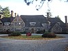
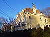
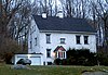
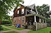
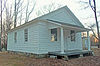
Small cluster of mid-19th century Federal and Greek Revival houses and Presbyterian Church is rare remaining group of buildings in those styles in area, and beginning of settlement of Armonk.
8 Bedford Village Historic District
Bedford Village Historic District Bedford Village Historic District-1787 Court House Dec 10.jpg
Bedford Village Historic District
October 2, 1973
(#73001285)
Roughly bounded by Court, Seminary, Poundridge and Greenwich Rds.
41°12′14″N73°38′22″W / 41.203889°N 73.639444°W / 41.203889; -73.639444 (Bedford Village Historic District)
Bedford
9 Brandreth Pill Factory
Brandreth Pill Factory Brandreth Pill Factory buildings, Ossining, NY.jpg
Brandreth Pill Factory
January 10, 1980
(#80002792)
Water St.
41°09′54″N73°52′11″W / 41.165°N 73.869722°W / 41.165; -73.869722 (Brandreth Pill Factory)
Ossining Benjamin Brandreth's facility was beginning of Ossining's industrial development when built in the 1830s. Later modified and expanded; stayed in operation until the 1940s; largely demolished in 2015 after damage from Superstorm Sandy.
10 Bridge L-158
Bridge L-158 Bridge L-158, Goldens Bridge, NY.jpg
Bridge L-158
November 29, 1978
(#78001923)
West of Goldens Bridge at Croton River
41°17′47″N73°40′59″W / 41.296389°N 73.683056°W / 41.296389; -73.683056 (Bridge L-158)
Goldens Bridge 
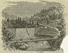
Only remaining double-intersection Whipple truss rail bridge in New York. Built in 1883 near Kingston and moved to this location in 1904. Out of service since 1960.
11 Bronx River Parkway Reservation
Bronx River Parkway Reservation Kensico dam.jpg
Bronx River Parkway Reservation
January 11, 1991
(#90002143)
Bronx River Pkwy. from jct. with Sprain Brook Rd. to and including Kensico Dam Plaza
41°04′04″N73°46′10″W / 41.067900°N 73.769540°W / 41.067900; -73.769540 (Bronx River Parkway Reservation)
Valhalla and Bronxville
12 Caramoor
Caramoor Caramoor Center.jpg
Caramoor
May 25, 2001
(#01000548)
149-181 Girdle Ridge Rd.
41°14′19″N73°38′48″W / 41.238611°N 73.646667°W / 41.238611; -73.646667 (Caramoor)
Bedford 1930s Renaissance Revival estate now used as classical music venue
13 Carrie Chapman Catt House
Carrie Chapman Catt House Carrie Chapman Catt House, Briarcliff Manor, NY.jpg
Carrie Chapman Catt House
May 4, 2006
(#06000336)
20 Ryder Rd.
41°10′35″N73°48′55″W / 41.176389°N 73.815278°W / 41.176389; -73.815278 (Carrie Chapman Catt House)
Briarcliff Manor Home of suffragist Carrie Chapman Catt at the time the 19th Amendment was ratified
14 Chappaqua Railroad Depot and Depot Plaza
Chappaqua Railroad Depot and Depot Plaza Chappaqua Depot House.png
Chappaqua Railroad Depot and Depot Plaza
April 19, 1979
(#79003210)
200 South Greeley Ave
41°09′28″N73°46′31″W / 41.157778°N 73.775278°W / 41.157778; -73.775278 (Chappaqua Railroad Depot and Depot Plaza)
Chappaqua 1902 station and park with war memorial and statue of Horace Greeley built on land donated by his daughter and son-in-law. Still used as waiting area.
15 Christ Episcopal Church
Christ Episcopal Church Christ Episcopal Church, Tarrytown, NY.jpg
Christ Episcopal Church
April 23, 1987
(#87000658)
Broadway and Elizabeth Sts.
41°04′30″N73°51′35″W / 41.075°N 73.859722°W / 41.075; -73.859722 (Christ Episcopal Church)
Tarrytown Washington Irving was member of this congregation, and his pew is still preserved. Built in 1837, this is the earliest Gothic Revival church in America
16 Church of Saint Mary the Virgin and Greeley Grove
Church of Saint Mary the Virgin and Greeley Grove Church of St Mary the Virgin, Chappaqua, NY.jpg
Church of Saint Mary the Virgin and Greeley Grove
April 19, 1979
(#79003213)
191 South Greeley Ave.
41°09′20″N73°46′21″W / 41.155556°N 73.7725°W / 41.155556; -73.7725 (Church of Saint Mary the Virgin and Greeley Grove)
Chappaqua Horace Greeley planted the grove as a windbreak and reforestation project in 1856. In 1904 his daughter and son-in-law built a private chapel modeled on a similarly-named church in England, which later donated one of its stained glass windows. It became an Episcopal parish in 1916.
17 Aaron Copland House
Aaron Copland House Aaron Copland House, Cortlandt Manor, NY.jpg
Aaron Copland House
September 19, 2003
(#03000245)
1538 Washington St.
41°14′25″N73°54′11″W / 41.240278°N 73.903056°W / 41.240278; -73.903056 (Aaron Copland House)
Cortlandt Manor Home of composer for last 30 years of his life
18 Gerard Crane House
Gerard Crane House Gerard Crane House, Somers, NY.jpg
Gerard Crane House
September 5, 1985
(#85001954)
Old Croton Falls Rd.
41°20′27″N73°40′30″W / 41.340833°N 73.675°W / 41.340833; -73.675 (Gerard Crane House)
Somers Sophisticated 1849 stone Greek Revival house
19 Old Croton Aqueduct
Old Croton Aqueduct Old Croton Aqueduct walkway, downtown Ossining, NY.jpg
Old Croton Aqueduct
December 2, 1974
(#74001324)
Runs N from Yonkers to New Croton Dam
41°12′52″N73°51′52″W / 41.214492°N 73.864447°W / 41.214492; -73.864447 (Old Croton Aqueduct)
VariousFirst long-distance aqueduct built to provide water from upstate to New York City. An engineering marvel in its time now used as a linear park
20 Croton North Railroad Station
Croton North Railroad Station Old Croton North station.jpg
Croton North Railroad Station
August 27, 1987
(#87001458)
Senasqua Rd.
41°12′25″N73°53′40″W / 41.206944°N 73.894444°W / 41.206944; -73.894444 (Croton North Railroad Station)
Croton-on-Hudson Intact 1890 station, now used as offices, exemplifies commuter rail stations of that era. Two former Erie Railroad cars on old siding included in listing.
21 Dale Cemetery
Dale Cemetery Benjamin Brandreth Grave.JPG
Dale Cemetery
July 17, 2013
(#13000500)
104 Havell St.
41°10′16″N73°51′22″W / 41.171039°N 73.856059°W / 41.171039; -73.856059 (Dale Cemetery)
Town of Ossining 1851 cemetery with graves of Thomas Allcock, Benjamin Brandreth and other local notables. Now owned by town.
22 Downtown Ossining Historic District
Downtown Ossining Historic District Downtown Ossining, NY.jpg
Downtown Ossining Historic District
August 9, 1989
(#88001827)
Roughly along US 9, Main St., and Croton Ave.
41°09′38″N73°51′42″W / 41.160556°N 73.861667°W / 41.160556; -73.861667 (Downtown Ossining Historic District)
Ossining Core of village reflecting impact of construction of Old Croton Aqueduct and 1870s fires.
23 Dutch Reformed Church
Dutch Reformed Church Old Dutch Church, Sleepy Hollow, NY.jpg
Dutch Reformed Church
October 15, 1966
(#66000581)
N edge of Tarrytown on U.S. 9
41°02′10″N73°51′47″W / 41.036111°N 73.863056°W / 41.036111; -73.863056 (Dutch Reformed Church)
Sleepy Hollow Surviving 1685 stone church built by Dutch is state's oldest church; figures prominently in Washington Irving's "The Legend of Sleepy Hollow"
24 Elephant Hotel
Elephant Hotel Elephant Hotel 2007.jpg
Elephant Hotel
August 7, 1974
(#74001323)
335 U.S. Route 202
41°19′43″N73°41′09″W / 41.328592°N 73.685783°W / 41.328592; -73.685783 (Elephant Hotel)
Somers Birthplace of the circus in America, when Zephaliah Bailey began charging visitors to see his elephant. Now used as a circus museum, offices of the Somers Historical Society and town hall.
25 First Baptist Church and Rectory
First Baptist Church and Rectory First Baptist Church of Tarrytown, NY.jpg
First Baptist Church and Rectory
July 21, 1983
(#83001829)
56 S. Broadway
41°04′28″N73°51′33″W / 41.074444°N 73.859167°W / 41.074444; -73.859167 (First Baptist Church and Rectory)
Tarrytown Victorian Gothic 1876 church designed by Russell Sturgis and patronized by Rockefellers.
26 First Baptist Church of Ossining
First Baptist Church of Ossining First Baptist Church of Ossining, NY.jpg
First Baptist Church of Ossining
January 12, 1973
(#73001288)
S. Highland Ave. and Main St.
41°09′41″N73°51′43″W / 41.161389°N 73.861944°W / 41.161389; -73.861944 (First Baptist Church of Ossining)
Ossining 1874 church is most advanced application of Gothic Revival style in Ossining; church was founded by town's founder
27 Marmaduke Forster House
Marmaduke Forster House Marmaduke Forster House 2.png
Marmaduke Forster House
February 22, 2011
(#11000139)
413-415 Bedford Rd.
41°08′04″N73°47′23″W / 41.134444°N 73.789722°W / 41.134444; -73.789722 (Marmaduke Forster House)
Pleasantville
28 Foster Memorial AME Zion Church
Foster Memorial AME Zion Church Foster Memorial AME Zion Church.jpg
Foster Memorial AME Zion Church
June 3, 1982
(#82003414)
90 Wildey St.
41°04′48″N73°51′44″W / 41.08°N 73.862222°W / 41.08; -73.862222 (Foster Memorial AME Zion Church)
Tarrytown Founded in 1860, this is the oldest black church in Westchester County and possibly one of the oldest in the state
29 Glenwolde Park Historic District
Glenwolde Park Historic District TarrytownNY GlenwoldeParkHD 2.jpg
Glenwolde Park Historic District
September 3, 2014
(#14000542)
Glenwolde Park, Walter St. & Willowbrook Ave.
41°03′32″N73°51′40″W / 41.058959°N 73.8611417°W / 41.058959; -73.8611417 (Glenwolde Park Historic District)
Tarrytown Tudor-styled residential district built during 1920s suburbanization
30 Greeley House
Greeley House Horace Greeley House.png
Greeley House
April 19, 1979
(#79003212)
100 King St.
41°09′32″N73°46′19″W / 41.158889°N 73.771944°W / 41.158889; -73.771944 (Greeley House)
Chappaqua Home of newspaper editor Horace Greeley, pioneering suburbanite, staunch abolitionist and 1872 presidential candidate. Much of today's downtown Chappaqua is built on land he farmed.
31 Hammond House
Hammond House Hammond House, Eastview, NY 02.jpg
Hammond House
May 6, 1980
(#80002790)
South of Hawthorne on Grasslands Rd.
41°04′34″N73°48′42″W / 41.076111°N 73.811667°W / 41.076111; -73.811667 (Hammond House)
Hawthorne 
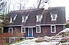
1720 home, modified twice in 19th century, is one of only two original tenant houses from the Van Cortlandt Manor left. Owned by the county historical society since 1926.
32 Edward Harden Mansion
Edward Harden Mansion Edward Harden Mansion, Sleepy Hollow, NY.jpg
Edward Harden Mansion
January 16, 2004
(#03001401)
200 North Broadway
41°04′58″N73°51′28″W / 41.082778°N 73.857778°W / 41.082778; -73.857778 (Edward Harden Mansion)
Sleepy Hollow 1909 Colonial Revival house built for journalist and investor Edward Harden was later home to first U.S. Montessori school
33 John A. Hartford House
John A. Hartford House Hartford-hall.jpg
John A. Hartford House
December 22, 1977
(#77000987)
Southwest of Valhalla on New York State Route 100
41°04′08″N73°47′25″W / 41.068889°N 73.790278°W / 41.068889; -73.790278 (John A. Hartford House)
Valhalla Home of founder of A & P; now part of Westchester Community College
34 Highland Cottage
Highland Cottage Highland Cottage, Ossining, NY.jpg
Highland Cottage
July 22, 1982
(#02001457)
36 S. Highland Ave.
41°09′35″N73°51′41″W / 41.159603°N 73.861269°W / 41.159603; -73.861269 (Highland Cottage)
Ossining 1872 reinforced-concrete Gothic Revival house
35 The Homestead
The Homestead 36 Mead Street from the front.JPG
The Homestead
March 29, 2001
(#01000294)
36 Mead St.
41°16′59″N73°35′44″W / 41.283056°N 73.595556°W / 41.283056; -73.595556 (The Homestead)
Waccabuc
36 Washington Irving High School
Washington Irving High School TarrytownNY FormerWashingtonIrvingHighSchool.jpg
Washington Irving High School
April 26, 1984
(#84003437)
18 N. Broadway
41°03′32″N73°51′28″W / 41.058889°N 73.857778°W / 41.058889; -73.857778 (Washington Irving High School)
Tarrytown
37 John Jay Homestead
John Jay Homestead John Jay Homestead 2007.jpg
John Jay Homestead
July 24, 1972
(#72000918)
Jay St.
41°15′01″N73°39′31″W / 41.250278°N 73.658611°W / 41.250278; -73.658611 (John Jay Homestead)
Katonah Home of John Jay, major landowner in area, first Chief Justice of the United States and early state governor
38 John Jones Homestead
John Jones Homestead John Jones Homestead.jpg
John Jones Homestead
May 25, 1989
(#89000462)
Oregon Rd. and Durrin Ave.
41°18′58″N73°54′00″W / 41.316111°N 73.9°W / 41.316111; -73.9 (John Jones Homestead)
Van Cortlandtville
39 Jug Tavern
Jug Tavern Jug Tavern, Ossining, NY.jpg
Jug Tavern
June 7, 1976
(#76001293)
Revolutionary Rd. and Rockledge Ave.
41°08′41″N73°51′52″W / 41.144722°N 73.864444°W / 41.144722; -73.864444 (Jug Tavern)
Ossining 1760s stop on former Albany Post Road route remains intact
40 Katonah Village Historic District
Katonah Village Historic District House in the Katonah Village Historic District.jpg
Katonah Village Historic District
September 15, 1983
(#83001830)
Parkway, Valleyedge, Edgemont and Bedford Rds.
41°15′20″N73°41′02″W / 41.255556°N 73.683889°W / 41.255556; -73.683889 (Katonah Village Historic District)
Katonah
41 Lyndhurst
Lyndhurst Lyndhurst Tarrytown NY - front facade.jpg
Lyndhurst
November 13, 1966
(#66000582)
635 S. Broadway
41°03′15″N73°51′58″W / 41.054167°N 73.866111°W / 41.054167; -73.866111 (Lyndhurst)
Tarrytown Stone Gothic Revival mansion purchased and expanded by rail baron Jay Gould
42 Richard H. Mandel House
Richard H. Mandel House Mandel House.jpg
Richard H. Mandel House
March 1, 1996
(#96000176)
323 Haines Rd.
41°14′40″N73°43′33″W / 41.244444°N 73.725833°W / 41.244444; -73.725833 (Richard H. Mandel House)
Bedford Hills
43 Mead Memorial Chapel
Mead Memorial Chapel Mead Memorial Chapel, front.JPG
Mead Memorial Chapel
November 30, 1999
(#99001443)
2 Chapel Rd.
41°17′47″N73°35′59″W / 41.296389°N 73.599722°W / 41.296389; -73.599722 (Mead Memorial Chapel)
Lewisboro
44 Merestead
Merestead Merestead.jpg
Merestead
September 27, 1984
(#84003431)
Byram Lake Rd.
41°10′31″N73°42′19″W / 41.175278°N 73.705278°W / 41.175278; -73.705278 (Merestead)
Mount Kisco
45 Miller House
Miller House Elijahmillerhouse.JPG
Miller House
September 29, 1976
(#76001292)
Virginia Rd.
41°03′33″N73°46′15″W / 41.059167°N 73.770833°W / 41.059167; -73.770833 (Miller House)
North White Plains
46 Mount Kisco Municipal Complex
Mount Kisco Municipal Complex Town Hall With Sun Flare.jpg
Mount Kisco Municipal Complex
March 9, 1997
(#97000116)
100-120 Main St.
41°12′09″N73°43′37″W / 41.2025°N 73.726944°W / 41.2025; -73.726944 (Mount Kisco Municipal Complex)
Mount Kisco
47 Mt. Zion Methodist Church
Mt. Zion Methodist Church Mt Zion Methodist Church, Somers, NY.jpg
Mt. Zion Methodist Church
May 10, 1990
(#90000692)
Primrose St. south of Reis Park
41°18′05″N73°42′54″W / 41.301389°N 73.715°W / 41.301389; -73.715 (Mt. Zion Methodist Church)
Somers 1794 church, remodeled in 1860, is early landmark in development of Methodism in New York
48 Music Hall
Music Hall Tarrytown Music Hall 2010.jpg
Music Hall
February 12, 1980
(#80002795)
11 Main St.
41°04′35″N73°51′33″W / 41.076389°N 73.859167°W / 41.076389; -73.859167 (Music Hall)
Tarrytown 1885 Queen Anne theater is one of the oldest in continuous use in the county
49 North Grove Street Historic District
North Grove Street Historic District 2 and 8 North Grove Street, Tarrytown, NY.jpg
North Grove Street Historic District
March 13, 1979
(#79001650)
1, 2, 8, 15, and 19 Grove St.
41°04′33″N73°51′27″W / 41.075833°N 73.8575°W / 41.075833; -73.8575 (North Grove Street Historic District)
Tarrytown Five 1860s houses built by local well-to-do mostly intact
50 North Salem Town Hall
North Salem Town Hall North Salem Town Hall.jpg
North Salem Town Hall
September 4, 1980
(#80002794)
Titicus Rd.
41°19′44″N73°35′51″W / 41.328889°N 73.5975°W / 41.328889; -73.5975 (North Salem Town Hall)
Salem Center
51 Old Chappaqua Historic District
Old Chappaqua Historic District Samuel Allen farm buildings, Chappaqua, NY.jpg
Old Chappaqua Historic District
July 15, 1974
(#74001319)
Quaker Rd.
41°10′16″N73°46′42″W / 41.171111°N 73.778333°W / 41.171111; -73.778333 (Old Chappaqua Historic District)
Chappaqua Farmhouses and other buildings clustered around 1753 Quaker meeting house that was the core of Chappaqua before the railroad.
52 Site of Old Croton Dam
Site of Old Croton Dam YorktownNY OldCrotonDam.jpg
Site of Old Croton Dam
June 19, 1973
(#73001289)
In the waters of the New Croton reservoir
41°13′39″N73°51′10″W / 41.227499°N 73.852872°W / 41.227499; -73.852872 (Site of Old Croton Dam)
Cortlandt
53 Old St. Peter's Church
Old St. Peter's Church Old St Peters Church.jpg
Old St. Peter's Church
March 7, 1973
(#73001292)
Oregon Rd. and Locust Ave.
41°18′49″N73°54′04″W / 41.313669°N 73.901175°W / 41.313669; -73.901175 (Old St. Peter's Church)
Van Cortlandtville
54 Osborn–Bouton–Mead House
Osborn-Bouton-Mead House SouthSalemNY OsbornBoutonMeadHouse.jpg
Osborn–Bouton–Mead House
September 15, 2004
(#04000990)
399 Pound Ridge Rd.
41°15′57″N73°33′59″W / 41.265833°N 73.566389°W / 41.265833; -73.566389 (Osborn–Bouton–Mead House)
South Salem
55 Palmer–Lewis Estate
Palmer-Lewis Estate SouthSalemNY PalmerLewisEstate3.jpg
Palmer–Lewis Estate
August 6, 1998
(#98001008)
Black Brook Rd.
41°13′50″N73°37′06″W / 41.230556°N 73.618333°W / 41.230556; -73.618333 (Palmer–Lewis Estate)
Bedford
56 Patriot's Park
Patriot's Park PatriotsParkMemorial-TarrytownNY-01.jpg
Patriot's Park
June 14, 1982
(#82003415)
US 9
41°04′53″N73°51′34″W / 41.081389°N 73.859444°W / 41.081389; -73.859444 (Patriot's Park)
Sleepy Hollow and Tarrytown 1853 monument to 1780 capture of British Major John André, exposing Benedict Arnold's betrayal of the Continental Army, was one of earliest to a Revolutionary War event. Later the park was a Carrère and Hastings residential development and two girls' schools.
57 Philipsburg Manor House
Philipsburg Manor House Philipsburg Manor, Sleepy Hollow, New York.JPG
Philipsburg Manor House
October 15, 1966
(#66000584)
381 Bellwood Ave.
41°05′14″N73°51′59″W / 41.087222°N 73.866389°W / 41.087222; -73.866389 (Philipsburg Manor House)
Sleepy Hollow Intact colonial-era manor house
58 Philipse Manor Railroad Station
Philipse Manor Railroad Station Philipse Manor train station building.jpg
Philipse Manor Railroad Station
March 14, 1991
(#91000237)
Jct. of Riverside Dr. and Millard
41°05′40″N73°52′12″W / 41.094444°N 73.87°W / 41.094444; -73.87 (Philipse Manor Railroad Station)
Sleepy Hollow 
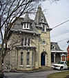
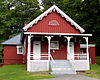
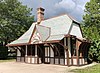
Restored octagonal Tudorbethan station house, home today to local writers' group, is intact surviving example of early 20th-century commuter rail station
59 Pound Ridge Historic District
Pound Ridge Historic District PoundRidgeNY HistoricDistrict5.jpg
Pound Ridge Historic District
December 30, 1985
(#85003196)
Roughly Pound Ridge, Old Stone Hill, and Salem Rds., Trinity Pass and Westchester Ave.
41°12′35″N73°34′34″W / 41.209722°N 73.576111°W / 41.209722; -73.576111 (Pound Ridge Historic District)
Pound Ridge
60 Joseph Purdy Homestead
Joseph Purdy Homestead PurdysNY JosephPurdyHomestead.jpg
Joseph Purdy Homestead
January 25, 1973
(#73001290)
Jct. of NY 22 and 116
41°19′42″N73°39′21″W / 41.328333°N 73.655833°W / 41.328333; -73.655833 (Joseph Purdy Homestead)
Purdys
61 Rehoboth
Rehoboth Rehoboth, Chappaqua, NY.jpg
Rehoboth
April 19, 1979
(#79003214)
33 Aldridge Rd.
41°09′22″N73°46′10″W / 41.1561°N 73.7694°W / 41.1561; -73.7694 (Rehoboth)
Chappaqua Horace Greeley built what may be the first known concrete building as a dairy barn in 1856; later remodeled into a neo-Gothic house for his daughter by Ralph Adams Cram
62 Solomon Resnick House
Solomon Resnick House ChappaquaNY SolomonResnickHouse.jpg
Solomon Resnick House
April 22, 2021
(#100006488)
1256 Hardscrabble Rd.
41°11′06″N73°47′07″W / 41.1851°N 73.7852°W / 41.1851; -73.7852 (Solomon Resnick House)
Chappaqua
63 Robinwood Historic District
Robinwood Historic District OssiningNY RobinviewHD 4.jpg
Robinwood Historic District
April 5, 2019
(#100003632)
Tavano & Somerstown Rds.
41°10′28″N73°49′50″W / 41.1744°N 73.8305°W / 41.1744; -73.8305 (Robinwood Historic District)
Ossining Mid-Century Modern housing enclave
64 Rockefeller Pocantico Hills Estate Historic District
Rockefeller Pocantico Hills Estate Historic District Union Church of Pocantico Hills 01.JPG
Rockefeller Pocantico Hills Estate Historic District
November 4, 2019
(#100004554)
Bedford, Sleepy Hollow & Lake Rds. et al.
41°06′14″N73°49′24″W / 41.1040°N 73.8233°W / 41.1040; -73.8233 (Rockefeller Pocantico Hills Estate Historic District)
Pocantico Hills Encompasses most of the former Rockefeller estate holdings
65 John D. Rockefeller Estate
John D. Rockefeller Estate Kykuit, Tarrytown, NY - front facade.JPG
John D. Rockefeller Estate
May 11, 1976
(#76001290)
Pocantico Hills
41°05′23″N73°50′40″W / 41.0897°N 73.8444°W / 41.0897; -73.8444 (John D. Rockefeller Estate)
Mt. Pleasant 
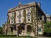
Kykuit, the estate of oil magnate and American dynasty founder John D. Rockefeller; open to public tours that also pass by his grandson Nelson's extensive modern art collection.
66 Franklin Delano Roosevelt Veterans Hospital Historic District July 15, 2022
(#100007887)
2094 Albany Post Rd.
41°14′41″N73°55′34″W / 41.2446°N 73.9261°W / 41.2446; -73.9261 (Franklin Delano Roosevelt Veterans Hospital Historic District)
Montrose
67 St. Augustine's Episcopal Church Complex
St. Augustine's Episcopal Church Complex CrotonNY StAugustinesParishHouse.jpg
St. Augustine's Episcopal Church Complex
July 26, 2006
(#06000648)
6 Old Post Rd. N
41°12′30″N73°53′13″W / 41.2083°N 73.8869°W / 41.2083; -73.8869 (St. Augustine's Episcopal Church Complex)
Croton-on-Hudson
68 St. George's Church
St. George's Church 20160927 St George's Church (The Winery) Mohegan Lake 2.jpg
St. George's Church
May 8, 2012
(#12000262)
1715 E. Main St.
41°19′27″N73°51′05″W / 41.3243°N 73.8515°W / 41.3243; -73.8515 (St. George's Church)
Mohegan Lake
69 St. John's Episcopal Church
St. John's Episcopal Church St John's Episcopal Church, Pleasantville, NY.jpg
St. John's Episcopal Church
January 31, 2017
(#100000616)
8 Sunnyside Ave.
41°08′06″N73°47′15″W / 41.1350°N 73.7874°W / 41.1350; -73.7874 (St. John's Episcopal Church)
Pleasantville 1912 Late Gothic church with later parish hall and 1800s building used as rectory are prominent local landmarks
70 St. Luke's Episcopal Church
St. Luke's Episcopal Church Stlukeschurchkatonahnyexterior.jpg
St. Luke's Episcopal Church
January 4, 2001
(#00001612)
68 Bedford Rd.
41°15′18″N73°41′04″W / 41.255°N 73.6844°W / 41.255; -73.6844 (St. Luke's Episcopal Church)
Katonah
71 St. Mark's Cemetery
St. Mark's Cemetery Saint Mark's Cemetery in December Snow.jpg
St. Mark's Cemetery
June 23, 1988
(#88000918)
E. Main St., corner of St. Mark's Pl.
41°11′40″N73°43′35″W / 41.1944°N 73.7264°W / 41.1944; -73.7264 (St. Mark's Cemetery)
Mount Kisco
72 St. Mark's Episcopal Church
St. Mark's Episcopal Church Saint Mark's Church.jpg
St. Mark's Episcopal Church
November 21, 1991
(#91001725)
Jct. of N. Bedford Rd. and E. Main St.
41°12′26″N73°43′35″W / 41.2072°N 73.7264°W / 41.2072; -73.7264 (St. Mark's Episcopal Church)
Mount Kisco
73 St. Paul's Episcopal Church and Rectory
St. Paul's Episcopal Church and Rectory Calvary Baptist Church, Ossining, NY.jpg
St. Paul's Episcopal Church and Rectory
December 6, 1978
(#78001925)
St. Paul's Pl.
41°09′35″N73°51′53″W / 41.1597°N 73.8647°W / 41.1597; -73.8647 (St. Paul's Episcopal Church and Rectory)
Ossining 1834 Gothic Revival church of Sing Sing marble designed by Calvin Pollard is oldest church in Ossining. Now Calvary Baptist Church.
74 Sarles' Tavern
Sarles' Tavern SarlesTavern.jpg
Sarles' Tavern
December 31, 1979
(#79001647)
NY 100
41°11′31″N73°47′56″W / 41.1919°N 73.7989°W / 41.1919; -73.7989 (Sarles' Tavern)
Millwood Demolished after 1993 fire
75 Scarborough Historic District
Scarborough Historic District Woodlea in Briarcliff Manor.tiff
Scarborough Historic District
September 7, 1984
(#84003433)
US 9
41°07′45″N73°51′22″W / 41.1292°N 73.8561°W / 41.1292; -73.8561 (Scarborough Historic District)
Briarcliff Manor Seven sites dating to between the 18th and 20th centuries, with a wide variety of Revival architecture styles
76 Sleepy Hollow Cemetery
Sleepy Hollow Cemetery SleepyHollowNY-entrance.jpg
Sleepy Hollow Cemetery
June 3, 2009
(#09000380)
540 N. Broadway
41°05′24″N73°51′43″W / 41.09°N 73.8619°W / 41.09; -73.8619 (Sleepy Hollow Cemetery)
Sleepy Hollow Setting in Washington Irving's The Legend of Sleepy Hollow; his final resting place along with many other famous people.
77 Smith Tavern
Smith Tavern Smith Tavern, Armonk, NY.jpg
Smith Tavern
September 15, 1983
(#83001833)
440 Bedford Rd.
41°07′35″N73°41′40″W / 41.1264°N 73.6944°W / 41.1264; -73.6944 (Smith Tavern)
Armonk 1770s tavern has played a variety of roles in the history of North Castle. Now used as local history museum.
78 Somers Hamlet Historic District
Somers Hamlet Historic District Houses in downtown Somers, NY.jpg
Somers Hamlet Historic District
April 21, 2004
(#04000349)
US 202, New York 100, New York 116, Deans Bridge Rd. and The Lane
41°19′42″N73°39′01″W / 41.3283°N 73.6503°W / 41.3283; -73.6503 (Somers Hamlet Historic District)
Somers 
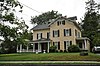
Core of village that arose in late 18th and early 19th centuries from junction of two widely used turnpikes; buildings show influence of both Hudson Valley and New England vernacular building traditions.
79 South Salem Presbyterian Church Cemetery
South Salem Presbyterian Church Cemetery South Salem Presbyterian Church Cemetery 001.JPG
South Salem Presbyterian Church Cemetery
September 10, 2014
(#14000586)
111 Spring St.
41°16′25″N73°33′24″W / 41.27352°N 73.55659°W / 41.27352; -73.55659 (South Salem Presbyterian Church Cemetery)
South Salem Veterans of the French and Indian War, Revolutionary War and War of 1812 among those buried here
80 Stepping Stones
Stepping Stones Stepping Stones, Katonah, NY.jpg
Stepping Stones
July 16, 2004
(#04000705)
62 Oak Rd.
41°14′56″N73°42′04″W / 41.2489°N 73.7011°W / 41.2489; -73.7011 (Stepping Stones)
Katonah Home of Alcoholics Anonymous cofounder Bill W. and his wife Lois in their later lives; AA's Big Book written here; National Historic Landmark designation October 16, 2012
81 Stonecrest
Stonecrest BedfordNY Stonecrest.jpg
Stonecrest
January 28, 2004
(#03001520)
703 Croton Lake Rd.
41°13′32″N73°43′40″W / 41.2256°N 73.7278°W / 41.2256; -73.7278 (Stonecrest)
Bedford Corners
82 Sunnyside
Sunnyside Sunnyside, Tarrytown, New York.JPG
Sunnyside
October 15, 1966
(#66000583)
Sunnyside Lane
41°02′57″N73°52′11″W / 41.0492°N 73.8697°W / 41.0492; -73.8697 (Sunnyside)
Tarrytown Riverside estate of Washington Irving
83 Taconic State Parkway
Taconic State Parkway Stone bridge on Taconic State Parkway near Shrub Oak, NY.jpg
Taconic State Parkway
December 8, 2005
(#05001398)
Linear north from North White Plains to Putnam County line
41°19′47″N73°49′06″W / 41.329700°N 73.818269°W / 41.329700; -73.818269 (Taconic State Parkway)
Mount Pleasant, Ossining, New Castle, Yorktown Scenic divided highway planned by Franklin D. Roosevelt for state park access. Built between the 1920s and early 1960s, epitomizing peak period of parkway design.
84 Tarrytown Lighthouse
Tarrytown Lighthouse Tarrytown Lighthouse and Tappan Zee Bridge.jpg
Tarrytown Lighthouse
May 29, 1979
(#79001649)
Spans Hudson River
41°05′02″N73°52′27″W / 41.083889°N 73.874167°W / 41.083889; -73.874167 (Tarrytown Lighthouse)
Sleepy Hollow 1883 lighthouse originally stood further offshore, until shore got closer. Only one on Hudson in Westchester and only conical steel lighthouse on Hudson to have family living quarters. Part of the Hudson River Lighthouses TR
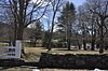
85 The Woodpile
The Woodpile BedfordNY TheWoodpile 2.jpg
The Woodpile
February 10, 1992
(#92000030)
Jct. of Croton Lake and Wood Rds.
41°13′42″N73°43′46″W / 41.228333°N 73.729444°W / 41.228333; -73.729444 (The Woodpile)
Bedford
86 Underhill–Acker House
Underhill-Acker House CrotonNY UnderhillAckerHouse.jpg
Underhill–Acker House
July 24, 2017
(#100001363)
4 Hamilton Ave.
41°12′18″N73°53′21″W / 41.20494°N 73.88920°W / 41.20494; -73.88920 (Underhill–Acker House)
Croton-on-Hudson Ornate 1873 Italianate house built for local physician
87 Union Church of Pocantico Hills
Union Church of Pocantico Hills UnionPocantico.tif
Union Church of Pocantico Hills
May 6, 2002
(#02000447)
555-559 Bedford Rd.
41°05′44″N73°49′58″W / 41.095556°N 73.832778°W / 41.095556; -73.832778 (Union Church of Pocantico Hills)
Pocantico Hills
88 Union Hall
Union Hall Union Hall North Salem NY Dec 10.jpg
Union Hall
August 28, 1986
(#86001978)
NY 116 and Keeler Ln.
41°20′07″N73°34′15″W / 41.335278°N 73.570833°W / 41.335278; -73.570833 (Union Hall)
North Salem
89 United Methodist Church and Parsonage
United Methodist Church and Parsonage United Methodist Church and Parsonage.jpg
United Methodist Church and Parsonage
November 4, 1982
(#82001278)
300 E. Main and 31 Smith Ave.
41°12′00″N73°43′35″W / 41.2°N 73.726389°W / 41.2; -73.726389 (United Methodist Church and Parsonage)
Mount Kisco A Carpenter Gothic church built in 1868, and its parsonage
90 Usonia Historic District
Usonia Historic District PleasantvilleNY UsoniaHD 6.jpg
Usonia Historic District
September 5, 2012
(#12000600)
Usonia & Rocky Vale Rds., Laurel Hill & Orchard Brook Drs.
41°07′42″N73°44′56″W / 41.12820°N 73.74901°W / 41.12820; -73.74901 (Usonia Historic District)
Pleasantville Community of houses designed by Frank Lloyd Wright
91 Van Cortlandt Manor
Van Cortlandt Manor Van-cortland-manor.jpg
Van Cortlandt Manor
October 15, 1966
(#66000579)
U.S. 9, north of the junction with U.S. 9A
41°11′46″N73°52′37″W / 41.196111°N 73.876944°W / 41.196111; -73.876944 (Van Cortlandt Manor)
Croton-on-Hudson Intact Georgian-style colonial manor house, located much further north than that style is usually found
92 Van Cortlandtville School
Van Cortlandtville School Van Cortlandtville School.jpg
Van Cortlandtville School
April 7, 1989
(#89000285)
297 Locust Ave.
41°18′45″N73°54′01″W / 41.3125°N 73.900278°W / 41.3125; -73.900278 (Van Cortlandtville School)
Van Cortlandtville
93 Waccabuc Historic District
Waccabuc Historic District WaccabucNY CountryClub.jpg
Waccabuc Historic District
July 28, 2015
(#15000236)
Mead St. & portions of Tarry-A-Bit Dr., Post Office & Chapel Rds.
41°17′26″N73°35′43″W / 41.290556°N 73.595278°W / 41.290556; -73.595278 (Waccabuc Historic District)
Waccabuc The district's 524 acres (212 ha) are the core of the Mead family landholdings around which the small hamlet of Waccabuc began developing in 1780, with many buildings from that and subsequent eras.
94 Washington School
Washington School Washington School, Ossining, NY.jpg
Washington School
February 12, 1987
(#87000080)
83 Croton Ave.
41°09′56″N73°51′30″W / 41.165556°N 73.858333°W / 41.165556; -73.858333 (Washington School)
Ossining 1907 school was first modern school in growing village. Monumentality achieved despite small size by Beaux-Arts style and placement on rise.
95 West Somers Methodist Episcopal Church and Cemetery
West Somers Methodist Episcopal Church and Cemetery West Somers Methodist Episcopal Church, Somers, NY.jpg
West Somers Methodist Episcopal Church and Cemetery
October 25, 2011
(#11000755)
199 Tomahawk St.
41°19′51″N73°45′04″W / 41.33093°N 73.75113°W / 41.33093; -73.75113 (West Somers Methodist Episcopal Church and Cemetery)
Somers 
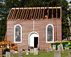
1837 chapel-style Greek Revival church with nearby graves of settlers from that era, one of the few remnants of when West Somers was a thriving community. Maintains historical integrity despite extensive renovations.
96 Williams–DuBois House
Williams-DuBois House Williams-Dubois House, New Castle, NY.jpg
Williams–DuBois House
May 25, 1989
(#89000463)
Grace Ln. and Pinesbridge Rd.
41°11′06″N73°49′41″W / 41.185°N 73.828056°W / 41.185; -73.828056 (Williams–DuBois House)
New Castle 1780 house is only known one from that era in town with gambrel roof
97 Witthoefft House
Witthoefft House Witthoefft House.png
Witthoefft House
February 22, 2011
(#11000039)
11 Tallwood Rd.
41°07′48″N73°44′13″W / 41.13°N 73.736944°W / 41.13; -73.736944 (Witthoefft House)
Armonk
98 Yorktown Heights Railroad Station
Yorktown Heights Railroad Station Former Yorktown Heights, NY, railroad station.jpg
Yorktown Heights Railroad Station
March 19, 1981
(#81000419)
Commerce St.
41°16′16″N73°46′49″W / 41.271111°N 73.780278°W / 41.271111; -73.780278 (Yorktown Heights Railroad Station)
Yorktown Heights 1877 station is one of only three New York and Putnam Railroad stations remaining in county, and one of only two of this size.
99 Isaac Young House
Isaac Young House Isaac Young House, New Castle, NY.jpg
Isaac Young House
August 20, 2004
(#04000876)
114 Pinesbridge Rd.
41°11′43″N73°49′00″W / 41.195278°N 73.816667°W / 41.195278; -73.816667 (Isaac Young House)
New Castle 1872 Second Empire house built over earlier farmhouse in rural area, unusual for that style. Maintains high level of integrity.

Former listing

[3] Name on the RegisterImageDate listedDate removedLocationCity or townDescription
1 George Rohr Saloon and Boardinghouse December 1, 1978
(#78001924)
Unknown1-3 Highland Ave.
Ossining Currently a parking lot for the Trinity Episcopal Church [5]

See also

Related Research Articles

Westchester County, New York County in New York, United States

Westchester County is located in the U.S. state of New York. It is the seventh most populous county in the State of New York and the most populous north of New York City. According to the 2020 United States Census, the county had a population of 1,004,456, an increase of 55,344 (5.8%) from the 949,113 counted in 2010. Situated in the Hudson Valley, Westchester covers an area of 450 square miles (1,200 km2), consisting of six cities, 19 towns, and 23 villages. Established in 1683, Westchester was named after the city of Chester, England. The county seat is the city of White Plains, while the most populous municipality in the county is the city of Yonkers, with 211,569 residents per the 2020 U.S. Census.

Cortlandt, New York Town in New York, United States

Cortlandt is a town in Westchester County, New York, United States, located at the northwestern edge of the county, at the eastern terminus of the Bear Mountain Bridge. The town includes the villages of Buchanan and Croton-on-Hudson.

Northern Westchester refers to the upper portion of Westchester County, New York, a suburban area north of New York City. Lying north of Interstate 287/Cross Westchester Expressway, these communities are distinguished by distance from New York City and their more rural character from those of Southern Westchester. The area is notable for its general affluence and high degree of watershed for New York City, being home to two major collection reservoirs supplying drinking water to it, the New Croton Reservoir and the Kensico Reservoir.

Cortlandt Manor, New York Unincorporated area in New York, United States

Cortlandt Manor is a hamlet located in the Town of Cortlandt in northern Westchester County, New York, United States. Cortlandt Manor is situated directly east, north and south of Peekskill, and east of three sections of the Town of Cortlandt, Croton-on-Hudson, Crugers, and Montrose. Most of the area is made up of residential homes. Cortlandt Manor also encompasses Cortlandt Estates.

Croton Aqueduct Pipeline that carried water to New York City from its reservoirs in 19th century

The Croton Aqueduct or Old Croton Aqueduct was a large and complex water distribution system constructed for New York City between 1837 and 1842. The great aqueducts, which were among the first in the United States, carried water by gravity 41 miles (66 km) from the Croton River in Westchester County to reservoirs in Manhattan. It was built because local water resources had become polluted and inadequate for the growing population of the city. Although the aqueduct was largely superseded by the New Croton Aqueduct, which was built in 1890, the Old Croton Aqueduct remained in service until 1955.

New York State Route 35 (NY 35) is the principal east–west highway in the northern part of Westchester County, New York, carrying average daily volumes of around 16,500 vehicles. Its western terminus is at US 9 in Peekskill, while its eastern terminus is at the Connecticut state line in Lewisboro, where it becomes that state's Route 35.

National Register of Historic Places listings in Herkimer County, New York

List of the National Register of Historic Places listings in Herkimer County, New York

National Register of Historic Places listings in Westchester County, New York

This is a list of the National Register of Historic Places listings in Westchester County, New York.

There are forty-five local police agencies in Westchester County, New York. As well as other county, state, and federal agencies responsible for protecting Westchester County, these agencies frequently work with one another and other agencies located in the surrounding counties and states as well as the NYPD. Current economic times has caused a few Westchester municipalities to consider consolidation of police services. The Westchester County Department of Public Safety started providing primary police services for the Town/Village of Mount Kisco in 2015.

List of the National Register of Historic Places listings in Rhinebeck, New York

National Register of Historic Places listings in Yonkers, New York

This is a list of the National Register of Historic Places entries in Yonkers, New York. See also National Register of Historic Places listings in Westchester County, New York for all others in the county.

National Register of Historic Places listings in Bedford County, Virginia

This is a list of the National Register of Historic Places listings in Bedford County, Virginia.

This is a list of the National Register of Historic Places entries in Peekskill, New York. See also National Register of Historic Places listings in Westchester County, New York for all other listings in the county.

This is a list of the National Register of Historic Places entries in New Rochelle, New York. See also National Register of Historic Places listings in Westchester County, New York for all others in the county.

National Register of Historic Places listings in Salem, Massachusetts

This is a list of the National Register of Historic Places listings in Salem, Massachusetts.

Downtown Ossining Historic District Older core of village in Westchester County, New York

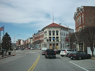
The Downtown Ossining Historic District is located at the central crossroads of Ossining, New York, United States, and the village's traditional business district known as the Crescent. Among its many late 19th- and early 20th-century commercial buildings are many of the village's major landmarks—three bank buildings, four churches, its village hall, former post office and high school. It was recognized as a historic district in 1989 and listed on the National Register of Historic Places, as one of the few downtowns in Westchester County with its social and historical development intact.

Sparta, Ossining

Sparta is a neighborhood of the village of Ossining in Westchester County, New York, United States. Sparta borders the Hudson River, south of most of the village of Ossining. The neighborhood was a hamlet of the town of Ossining, and remains its oldest community. Sparta was founded by Dutch settlers in the 17th century. It has zip codes 10510 and 10562. The elevation is 56 feet.

National Register of Historic Places listings in southern Westchester County, New York

This is a list of the National Register of Historic Places listings in southern Westchester County, New York, excluding the cities of New Rochelle and Yonkers, which have separate lists of their own.

History of Westchester County

The history of Westchester County, a county in the state of New York, can be traced back to the founding of a settlement between the Hudson River and Long Island Sound in the 17th century. The area now known as Westchester County had seen human occupation since at least the Archaic period, but significant growth in the settlements that are now incorporated into the county did not occur until the Industrial Revolution.

There are numerous nationally and locally designated historic sites and attractions in Westchester County. These include architecturally significant manors and estates, churches, cemeteries, farmhouses, African-American heritage sites, and underground railroad depots and waystations. There are sites from pre-Revolutionary and Revolutionary times, as well as battlegrounds. Westchester County also played an important role in the development of the modern suburb, and there are many associated heritage sites and museums.

References

  1. The latitude and longitude information provided in this table was derived originally from the National Register Information System, which has been found to be fairly accurate for about 99% of listings. Some locations in this table may have been corrected to current GPS standards.
  2. National Park Service, United States Department of the Interior, "National Register of Historic Places: Weekly List Actions", retrieved July 22, 2022.
  3. 1 2 Numbers represent an alphabetical ordering by significant words. Various colorings, defined here, differentiate National Historic Landmarks and historic districts from other NRHP buildings, structures, sites or objects.
  4. The eight-digit number below each date is the number assigned to each location in the National Register Information System database, which can be viewed by clicking the number.
  5. The Museum in the Streets - Ossining, New York

Further reading