Thornwood, New York | |
---|---|
Coordinates: 41°7′18″N73°46′37″W / 41.12167°N 73.77694°W | |
Country | United States |
State | New York |
County | Westchester |
Town | Mount Pleasant |
Area | |
• Total | 1.12 sq mi (2.89 km2) |
• Land | 1.12 sq mi (2.89 km2) |
• Water | 0.00 sq mi (0.00 km2) |
Elevation | 269 ft (82 m) |
Population (2020) | |
• Total | 3,960 |
• Density | 3,545.21/sq mi (1,368.99/km2) |
Time zone | UTC-5 (Eastern (EST)) |
• Summer (DST) | UTC-4 (EDT) |
ZIP Code | 10594 |
Area code | 914 |
FIPS code | 36-73715 |
GNIS feature ID | 0967439 |
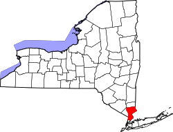
Thornwood is a hamlet (unincorporated community), census-designated place (CDP), and postal designation (with zip code 10594) in the town of Mount Pleasant in Westchester County, New York. The population was 3,759 at the 2010 census. [2]
In 1891, Lewis Smadback started a very successful development at what is now Thornwood. The village of Sherman Park was incorporated in 1906 and the name was changed to Hillside in 1909. The village was dissolved in 1914, when Thornwood took its current name and became a hamlet within the Town of Mount Pleasant. It is possible that Thornwood is a derivative of "Hawthorne's Woods," since Hawthorne is an adjacent hamlet. Another possibility is Thornwood is named after an area in Glasgow, Scotland.
Thornwood once had a large and thriving Westchester marble quarry near its heart, the intersection of Route 141 and Kensico Road (known as Four Corners). Dating back to 1845, the quarry supplied white marble which helped build St. Patrick's Cathedral (hence the name of Marble Avenue which runs through the hamlet). The quarry pit was filled in during the mid-1980s, and the Town Center shopping mall was constructed over it.
Thornwood once had a station on the Harlem Line of the Metro-North Railroad and was approximately a 48-minute ride to Grand Central Terminal. The station building remains on Commerce Street, but the stop was eliminated when the up-starter Harlem Line (north of North White Plains) was electrified in the mid-1980s. Thornwood was the only stop eliminated as a result of the electrification process. While the station could accommodate diesel trains, the curvature of the tracks as proceeding north to Pleasantville made the construction at Thornwood of an elevated platform, necessary for electric trains, impractical.
The death of baby Kristie Fischer took place in 1991.
Thornwood is located at 41°7′18″N73°46′37″W / 41.12167°N 73.77694°W (41.121557, -73.777071). [3] According to the U.S. Census Bureau, the hamlet has a total area of 1.1 square miles (2.9 km2), all land. [4]
Census | Pop. | Note | %± |
---|---|---|---|
2020 | 3,960 | — | |
U.S. Decennial Census [5] |
As of the census [6] of 2000, there were 5,980 people, 1,886 households, and 1,559 families residing in the hamlet. The population density was 1,760.9 inhabitants per square mile (679.9/km2). There were 1,921 housing units at an average density of 565.7 per square mile (218.4/km2). The racial makeup of the hamlet was 90.97% White, 2.36% African American, 0.03% Native American, 4.00% Asian, 0.07% Pacific Islander, 1.39% from other races, and 1.19% from two or more races. Hispanic or Latino of any race were 5.80% of the population.
There were 1,886 households, out of which 40.7% had children under the age of 18 living with them, 72.5% were married couples living together, 7.2% had a female householder with no husband present, and 17.3% were non-families. 14.8% of all households were made up of individuals, and 6.9% had someone living alone who was 65 years of age or older. The average household size was 3.06 and the average family size was 3.39.
The population is spread out with 28.3% under the age of 18, 6.3% from 18 to 24, 28.3% from 25 to 44, 23.9% from 45 to 64, and 13.3% who were 65 years of age or older. The median age was 38 years. For every 100 females, there were 97.8 males. For every 100 females age 18 and over, there were 95.7 males.
The median income for a household in the hamlet was $88,971, and the median income for a family was $98,313. Males had a median income of $73,438 versus $40,365 for females. The per capita income for the hamlet was $36,254. About 2.2% of families and 4.0% of the population were below the poverty line, including 2.6% of those under age 18 and 3.9% of those age 65 or over.
Thornwood is the home to the North American headquarters for the Carl Zeiss Corporation, a multinational German manufacturer of optical systems, industrial measurements and medical devices.
The Legion of Christ, a Roman Catholic religious institute, operates the Our Lady of Thornwood Conference, Education and Training Center on the site of a former IBM facility on Columbus Avenue. The seminarians studying here for the Catholic priesthood usually major in philosophy at the Thornwood Conference Center. However, due to a lack of vocations and private funds—partly due to the abuse scandal caused by the order's founder, Father Marcial Maciel Degollado, which resulted in a Vatican investigation and revision—the entire course of Seminary studies will now be taken at the Legionaries' Seminary in Rome, Italy and the building will be sold. [7]
Thornwood's residents are served by the Mt. Pleasant Police Department and the volunteer Thornwood Fire Department. The fire department serves approximately 5,000 residents in a 5-square-mile (13 km2) suburban area. Its equipment includes:
Thornwood is under the jurisdiction of Pleasantville Volunteer Ambulance Corps. The Pleasantville VAC fleet consists of 7601, 7602, 7603, Rehab 7605, and Captains Car 7611. They are located at 30 Gramercy Place in Thornwood across from the town center.
Thornwood is part of the Mt. Pleasant Central School District, which includes the Hawthorne Elementary, Columbus Elementary School, Westlake Middle School and Westlake High School. The former Thornwood Elementary School was closed and converted to condominiums in the 1980s, and the former Thornwood Junior High School later became Columbus Elementary School.
Del Aire is a census-designated place (CDP) in the inland South Bay, Los Angeles County, California, United States, between El Segundo and Hawthorne. The population was 10,001 at the 2010 census, up from 9,012 at the 2000 census.
Silver Springs Shores is a census-designated place (CDP) in Marion County, Florida, United States. The population was 24,846 at the 2020 census. It is part of the Ocala Metropolitan Statistical Area.
Olympia Heights is a census-designated place in Miami-Dade County, Florida, United States. It is located in the Miami metropolitan area of South Florida. The population was 12,873 at the 2020 census.
Westchester is a census-designated place (CDP) and neighborhood in Miami-Dade County, Florida. It is part of the Miami metropolitan area of South Florida. Prior to the 2020 U.S. Census, the neighboring University Park CDP was merged into Westchester CDP, effectively doubling its geography and population. Per the 2020 census, the population was 56,384.
Westwood Lakes is a census-designated place and unincorporated community of Miami-Dade County, Florida, United States. It is part of the Miami metropolitan area of South Florida. The population was 11,373 at the 2020 census.
Village St. George is a census-designated place (CDP) in East Baton Rouge Parish, Louisiana, United States. The population was 7,104 at the 2010 census. It is part of the Baton Rouge Metropolitan Statistical Area.
Lake Fenton is a census-designated place (CDP) in Fenton Charter Township, Genesee County in the U.S. state of Michigan. As of the 2010 census the population was 5,559, up from 4,876 at the 2000 census. The CDP includes the unincorporated communities of Bayport Park and Lakeside.
Redwater is a census-designated place (CDP) in Leake County, Mississippi, United States. It is one of the eight communities of the Mississippi Band of Choctaw Indians Reservation, and the population is 61% Choctaw. The population was 633 at the 2010 census, up from 409 at the 2000 census.
North Wantagh is a hamlet and census-designated place in the Town of Hempstead in Nassau County, on the South Shore of Long Island, in New York, United States. The population was 11,960 at the 2010 census.
Central Islip is a hamlet and census-designated place (CDP) within the Town of Islip in Suffolk County, New York, United States. The population was 34,450 at the 2010 census.
Crompond is a hamlet and census-designated place (CDP) located in the town of Yorktown in Westchester County, New York, United States. The population was 2,292 at the 2010 census.
Fairview is a hamlet and a census-designated place (CDP) located in the town of Greenburgh, Westchester County, New York, United States. The population was 3,099 at the 2010 census. As of 2000, Fairview had the fourth-highest percentage of African-Americans in New York.
Goldens Bridge is a hamlet and census-designated place (CDP) in the town of Lewisboro in Westchester County, New York, United States. The population was 1,630 at the 2010 census.
Hawthorne is a hamlet and census-designated place (CDP) located in the town of Mount Pleasant in Westchester County, New York, United States. The population was 4,586 at the 2010 census.
Lincolndale is a hamlet and census-designated place (CDP) located in the town of Somers in Westchester County, New York, United States. The population was 1,521 at the 2010 census.
Mount Pleasant is a town in Westchester County, New York, United States, in the New York metropolitan area. As of the 2020 census, the town population was 44,436. The hamlets of Valhalla, Hawthorne, Pocantico Hills, and Thornwood, and the villages of Pleasantville, Sleepy Hollow, and a small portion of Briarcliff Manor lie within the town.
New Castle is a town in Westchester County, New York, United States. The population was 18,311 in the 2020 United States census, an increase over 17,569 at the 2010 census. It includes the hamlets of Chappaqua and Millwood.
Scotts Corners is a hamlet located in the town of Pound Ridge in Westchester County, New York, United States. As of the 2010 census, the CDP population was 711, making Scotts Corners Westchester County's smallest census-recognized area.
Valhalla is a hamlet and census-designated place (CDP) within the town of Mount Pleasant, in Westchester County, New York, United States, in the New York City metropolitan area. Its population was 3,162 at the 2010 U.S. Census. The name was inspired by a fan of the composer Richard Wagner, and the hamlet is known both as the home of the primary hospital campus of Westchester Medical Center and New York Medical College and as the burial place of numerous noted people. Valhalla is the realm of the gods in Norse mythology.
Jefferson Valley-Yorktown, commonly known as Jefferson Valley, is a census-designated place (CDP) located in the town of Yorktown in Westchester County, New York, United States. The population was 14,142 at the 2010 census. It is a hot spot for local shoppers, due to its Jefferson Valley Mall.