Fairview, Westchester County, New York

Last updated
Fairview, New York
CDP
Westchester County New York incorporated and unincorporated areas Fairview highlighted.svg
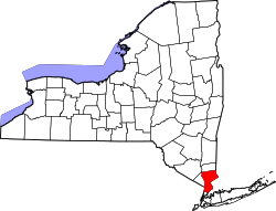
Location of Fairview, Westchester County, New York
Coordinates: 41°2′37″N73°47′52″W / 41.04361°N 73.79778°W / 41.04361; -73.79778
Country United States
State New York
County Westchester
Town Greenburgh
Area
  Total0.4 sq mi (1 km2)
  Land0.4 sq mi (1 km2)
Population
 (2010)
  Total3,099
  Density7,700/sq mi (3,000/km2)
Time zone UTC-5 (Eastern (EST))
  Summer (DST) UTC-4 (EDT)

Fairview is a hamlet and a census-designated place (CDP) located in the town of Greenburgh, Westchester County, New York, United States. The population was 3,099 at the 2010 census. [1] As of 2000, Fairview had the fourth-highest percentage of African-Americans in New York.

Contents

Geography

Fairview is located at 41°2′37″N73°47′52″W / 41.04361°N 73.79778°W / 41.04361; -73.79778 (41.043638, -73.797656). [2] According to the United States Census Bureau, the CDP has a total area of 0.4 square miles (1.0 km2), all land. Fairview is roughly four miles east of the Hudson River.

Major Roads

Demographics

2020 census

Fairview CDP, Westchester County, New York – racial and ethnic composition
(NH = Non-Hispanic)
Note: the US Census treats Hispanic/Latino as an ethnic category. This table excludes Latinos from the racial categories and assigns them to a separate category. Hispanics/Latinos may be of any race.
Race / EthnicityPop 2010 [4] Pop 2020 [5] % 2010% 2020
White alone (NH)1411554.55%4.82%
Black or African American alone (NH)1,7481,58656.41%49.30%
Native American or Alaska Native alone (NH)180.03%0.25%
Asian alone (NH)941323.03%4.10%
Pacific Islander alone (NH)300.10%0.00%
Some Other Race alone (NH)17260.55%0.81%
Mixed Race/Multi-Racial (NH)59941.90%2.92%
Hispanic or Latino (any race)1,0361,21633.43%37.80%
Total3,0993,217100.00%100.00%

2000 Census

As of the census [6] of 2000, there were 2,887 people, 936 households, and 673 families residing in the CDP. The population density was 6,735.2 inhabitants per square mile (2,600.5/km2). There were 952 housing units at an average density of 2,221.0 per square mile (857.5/km2). The racial makeup of the CDP was 11.50% White, 73.09% African American, 0.21% Native American, 2.81% Asian, 0.31% Pacific Islander, 6.34% from other races, and 5.75% from two or more races. Hispanic or Latino of any race were 14.20% of the population.

There were 936 households, of which 32.9% had children under 18 living with them, 36.9% were married couples living together, 28.6% had a female householder with no husband present, and 28.0% were non-families. 23.5% of all households were made up of individuals, and 11.1% had someone living alone who was 65 years of age or older. The average household size was 3.04 and the average family size was 3.53.

In the CDP the population was spread out, with 26.7% under the age of 18, 8.2% from 18 to 24, 30.4% from 25 to 44, 22.3% from 45 to 64, and 12.4% who were 65 years of age or older. The median age was 36 years. For every 100 females, there were 87.8 males. For every 100 females age 18 and over, there were 80.3 males.

The median income for a household in the CDP was $50,905, and the median income for a family was $60,259. Males had a median income of $32,276 versus $34,448 for females. The per capita income for the CDP was $24,219. About 9.3% of families and 12.0% of the population were below the poverty line, including 15.6% of those under age 18 and 20.0% of those age 65 or over.

Related Research Articles

<span class="mw-page-title-main">Chuichu, Arizona</span> CDP in Pinal County, Arizona

Chuichu is a census-designated place (CDP) in Pinal County, Arizona, United States. The population was 308 at the 2020 census. It is the northernmost traditional village on the Tohono O'odham Nation reservation.

<span class="mw-page-title-main">Fairview, Monmouth County, New Jersey</span> Census-designated place in New Jersey, United States

Fairview is an unincorporated community and census-designated place (CDP) located within Middletown Township, in Monmouth County, New Jersey, United States. As of the 2010 United States Census, the CDP's population was 3,806.

<span class="mw-page-title-main">Arlington, New York</span> Census-designated place in New York, United States

Arlington is a neighborhood and census-designated place (CDP) in the town of Poughkeepsie, Dutchess County, New York, United States. At the 2010 census, the CDP population was 4,061.

<span class="mw-page-title-main">Crown Heights, New York</span> Census-designated place in New York, United States

Crown Heights is a hamlet and census-designated place (CDP) in Dutchess County, New York, United States. The population was 2,840 at the 2010 census. It is part of the Poughkeepsie–Newburgh–Middletown, NY Metropolitan Statistical Area as well as the larger New York–Newark–Bridgeport, NY-NJ-CT-PA Combined Statistical Area.

<span class="mw-page-title-main">Fairview, Dutchess County, New York</span> Census-designated place in New York, United States

Fairview is a hamlet and census-designated place (CDP) in Dutchess County, New York, United States. The population was 5,515 at the 2010 census. It is part of the Poughkeepsie–Newburgh–Middletown, NY Metropolitan Statistical Area as well as the larger New York–Newark–Bridgeport, NY-NJ-CT-PA Combined Statistical Area.

<span class="mw-page-title-main">Haviland, New York</span> Census-designated place in New York, United States

Haviland is a community and census-designated place (CDP) in Dutchess County, New York, United States. The population was 3,634 at the 2010 census. It is part of the Poughkeepsie–Newburgh–Middletown, NY Metropolitan Statistical Area as well as the larger New York–Newark–Bridgeport, NY-NJ-CT-PA Combined Statistical Area.

<span class="mw-page-title-main">Lake Katrine, New York</span> CDP in New York, United States

Lake Katrine is a hamlet in Ulster County, New York, United States. The population was 2,522 at the 2020 census.

<span class="mw-page-title-main">Crompond, New York</span> CDP in New York, United States

Crompond is a hamlet and census-designated place (CDP) located in the town of Yorktown in Westchester County, New York, United States. The population was 2,292 at the 2010 census.

<span class="mw-page-title-main">Crugers, New York</span> Hamlet and census-designated place in Cortlandt, New York

Crugers is a hamlet and census-designated place (CDP) located in the town of Cortlandt, Westchester County, New York, United States. The population was 1,534 at the 2010 census.

<span class="mw-page-title-main">Greenburgh, New York</span> Town in New York, United States

Greenburgh is a town in western Westchester County, New York. The population was 95,397 at the time of the 2020 census.

<span class="mw-page-title-main">Heritage Hills, New York</span> Census-designated place in New York, United States

Heritage Hills is a hamlet (CDP) located in the town of Somers in Westchester County, New York, United States. The population was 3,975 at the 2010 census.

<span class="mw-page-title-main">Mohegan Lake, New York</span> CDP in New York, United States

Lake Mohegan, commonly known as Mohegan Lake, is a census-designated place (CDP) located in the Town of Yorktown in Westchester County, New York, United States.

<span class="mw-page-title-main">Lincolndale, New York</span> Census-designated place in New York, United States

Lincolndale is a hamlet and census-designated place (CDP) located in the town of Somers in Westchester County, New York, United States. The population was 1,521 at the 2010 census.

<span class="mw-page-title-main">Scotts Corners, New York</span> CDP in New York, United States

Scotts Corners is a hamlet located in the town of Pound Ridge in Westchester County, New York, United States. As of the 2010 census, the CDP population was 711, making Scotts Corners Westchester County's smallest census-recognized area.

<span class="mw-page-title-main">Shenorock, New York</span> CDP in New York, United States

Shenorock is a hamlet and census-designated place (CDP) located in the town of Somers in Westchester County, New York, United States. The population was 1,898 at the 2010 census.

<span class="mw-page-title-main">Yorktown Heights, New York</span> Census-designated place in New York, United States

Yorktown Heights is a census-designated place (CDP) in the town of Yorktown in Westchester County, New York, United States. The population was 1,781 at the 2010 census.

<span class="mw-page-title-main">Great Barrington (CDP), Massachusetts</span> Census-designated place in Massachusetts, United States

Great Barrington is a census-designated place (CDP) located in the town of Great Barrington in Berkshire County, Massachusetts, United States. The population was 2,231 at the 2010 census, out of 7,104 in the entire town of Great Barrington.

<span class="mw-page-title-main">Amenia (CDP), New York</span> Hamlet in the state of New York, United States

Amenia is a hamlet and census-designated place (CDP) in Dutchess County, New York, United States. The population was 955 at the 2010 census. It is part of the Poughkeepsie–Newburgh–Middletown, NY Metropolitan Statistical Area as well as the larger New York–Newark–Bridgeport, NY-NJ-CT-PA Combined Statistical Area.

<span class="mw-page-title-main">Liberty (village), New York</span> Village in New York, United States

Liberty is a village in Sullivan County, New York, United States. The population was 4,700 at the 2020 census.

<span class="mw-page-title-main">Jefferson Valley, New York</span> Census-designated place in New York, United States

Jefferson Valley-Yorktown, commonly known as Jefferson Valley, is a census-designated place (CDP) located in the town of Yorktown in Westchester County, New York, United States. The population was 14,142 at the 2010 census. It is a hot spot for local shoppers, due to its Jefferson Valley Mall.

References

  1. "Profile of General Population and Housing Characteristics: 2010 Demographic Profile Data (DP-1): Fairview CDP (Westchester County), New York". United States Census Bureau . Retrieved November 21, 2011.
  2. "US Gazetteer files: 2010, 2000, and 1990". United States Census Bureau. 2011-02-12. Retrieved 2011-04-23.
  3. "google maps". 2012. Retrieved December 21, 2012.
  4. "P2 HISPANIC OR LATINO, AND NOT HISPANIC OR LATINO BY RACE – 2010: DEC Redistricting Data (PL 94-171) – Fairview CDP, Westchester County, New York". United States Census Bureau .
  5. "P2 HISPANIC OR LATINO, AND NOT HISPANIC OR LATINO BY RACE - 2020: DEC Redistricting Data (PL 94-171) - Fairview CDP, Westchester County, New York". United States Census Bureau .
  6. "U.S. Census website". United States Census Bureau . Retrieved 2008-01-31.