
Westchester County is located in the U.S. state of New York. It is the seventh most populous county in the State of New York and the most populous north of New York City. According to the 2020 United States Census, the county had a population of 1,004,456, its highest decennial count ever and an increase of 55,344 (5.8%) from the 949,113 counted in 2010. Located in the Hudson Valley, Westchester covers an area of 450 square miles (1,200 km2), consisting of six cities, 19 towns, and 23 villages. Established in 1683, Westchester was named after the city of Chester, England. The county seat is the city of White Plains, while the most populous municipality in the county is the city of Yonkers, with 211,569 residents per the 2020 U.S. Census.

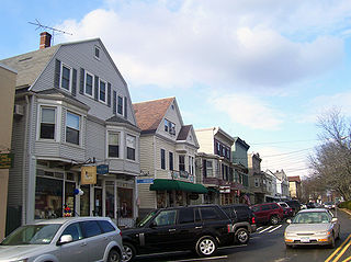
Chappaqua is a hamlet and census-designated place in the town of New Castle, in northern Westchester County, New York. It is approximately 30 miles (50 km) north of New York City. The hamlet is served by the Chappaqua station of the Metro-North Railroad's Harlem Line. In the New York State Legislature it is within the New York State Assembly's 93rd district and the New York Senate's 40th district. In Congress the village is in New York's 17th District.
Elmsford is a village in Westchester County, New York, United States. It is part of the New York metropolitan area. Roughly one mile square, the village is fully contained within the borders of the town of Greenburgh. As of the 2010 census, the population of Elmsford was 4,664.

Greenburgh is a town in western Westchester County, New York. The population was 95,397 at the time of the 2020 census.

Greenville, commonly known as Edgemont, is a census-designated place (CDP) in the town of Greenburgh in Westchester County, New York, United States. The population was 9,394 at the 2020 census. Most of its residents refer to the area as Edgemont, which is also the name of its school district.

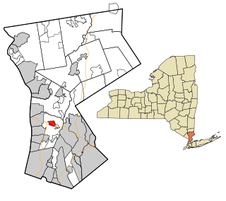
New Castle is a town in Westchester County, New York, United States. The population was 18,311 in the 2020 United States census, an increase over 17,569 at the 2010 census. It includes the hamlets of Chappaqua and Millwood.

Valhalla is a hamlet and census-designated place (CDP) within the town of Mount Pleasant, in Westchester County, New York, United States, in the New York City metropolitan area. Its population was 3,162 at the 2010 U.S. Census. The name was inspired by a fan of the composer Richard Wagner, and the hamlet is known both as the home of the primary hospital campus of Westchester Medical Center and New York Medical College and as the burial place of numerous noted people. Valhalla is the realm of the gods in Norse mythology.

Mount Kisco is a village and town in Westchester County, New York, United States. The town of Mount Kisco is coterminous with the village. The population was 10,959 at the 2020 United States census over 10,877 at the 2010 census.
Bedford is an incorporated town in Westchester County, New York. The population was 16,880 at the 2020 census.

Bedford Hills is a hamlet and census-designated place (CDP) in the town of Bedford, Westchester County, New York, United States. The population was 3,001 at the 2010 census. Two New York State prisons for women, Bedford Hills Correctional Facility for Women and Taconic Correctional Facility, are located in the hamlet.
Katonah is a hamlet and census-designated place (CDP) within the town of Bedford, Westchester County, in the U.S. state of New York. The Katonah CDP had a population of 1,679 at the 2010 census.
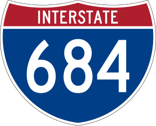
Interstate 684 (I-684) is a 28.47-mile-long (45.82 km) north–south auxiliary Interstate Highway in the state of New York in the United States. There is also a short portion in Connecticut with no junctions. The highway connects I-84 with I-287 and the Hutchinson River Parkway, primarily serving commuter traffic to and from the northern suburbs of the New York metropolitan area. Most of the route is in northern Westchester County. The route of the highway was originally designated as part of I-87 from 1968 to 1970. The first section of the roadway opened to traffic in October 1968, and the final segment was completed in December 1974.

The Saw Mill River Parkway is a north–south parkway that extends for 28.93 miles (46.56 km) through Westchester County, New York, in the United States. It begins at the border between Westchester County and the Bronx, as the continuation of the Henry Hudson Parkway leaving New York City, and heads generally northeastward to an interchange with Interstate 684 (I-684). At its north end, the parkway serves as a collector/distributor road as it passes east of the hamlet of Katonah. The parkway is named for the Saw Mill River, which the highway parallels for most of its length.

New York State Route 22 (NY 22) is a north–south state highway that parallels the eastern border of the U.S. state of New York, from the outskirts of New York City to the hamlet of Mooers in Clinton County near the Canadian border. At 337 miles (542 km), it is the state's longest north–south route and the third longest state route overall, after NY 5 and NY 17. Many of the state's major east–west roads intersect with, and often join, NY 22 just before crossing into the neighboring New England states, where U.S. Route 7 (US 7), which originally partially followed NY 22's alignment, similarly parallels the New York state line.
New York State Route 117 (NY 117) is a 15.57-mile (25.06 km) state highway in Westchester County, New York, in the United States. The southern terminus of the route is at an intersection with U.S. Route 9 (US 9) north of the village of Sleepy Hollow. The northern terminus is at an interchange with Interstate 684 (I-684) south of Katonah, a hamlet in the town of Bedford. NY 117 meets the Taconic State Parkway in Pleasantville and parallels the Saw Mill Parkway from Pleasantville to Bedford.

New York State Route 120 (NY 120) is a state highway in southern Westchester County, New York, in the United States. It begins in the city of Rye at an intersection with U.S. Route 1 (US 1) and runs for about 18 miles (29 km) north to the hamlet of Millwood, where it ends at a junction with NY 100. The route intersects with Interstate 684 (I-684) and the Saw Mill River Parkway, and serves the Westchester County Airport in North Castle. Portions of the route have been signed ceremonially in remembrance of American serviceman killed in the 2000s and 2010s during the wars in Iraq and Afghanistan.

New York State Route 172 (NY 172) is an 8.89-mile (14.31 km) state highway in Westchester County, New York, in the United States. The route runs from NY 117 in the village of Mount Kisco east to the hamlet of Pound Ridge at NY 137.

The Bedford Road Historic District is located along that street in the unincorporated hamlet of Armonk, New York, United States. Its 4.5 acres (1.8 ha) contain nine contributing properties, all wood frame buildings from the mid-19th century in variations and combinations of the Federal and Greek Revival architectural styles. In 1985 the group was recognized as a historic district and listed on the National Register of Historic Places.

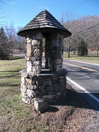
The Old Chappaqua Historic District is located along Quaker Road in the town of New Castle, New York, United States, between the hamlets of Chappaqua and Millwood. It was the original center of Chappaqua, prior to the construction of the New York and Harlem Railroad and the erection of its station to the south in the mid-19th century. In 1974 it was recognized as a historic district and listed on the National Register of Historic Places.

This is a list of the National Register of Historic Places listings in northern Westchester County, New York, excluding the city of Peekskill, which has its own list.

