Eastchester, New York | |
---|---|
Coordinates: 40°57′30″N73°48′31″W / 40.95833°N 73.80861°W | |
Country | United States |
State | New York |
County | Westchester |
Town | Eastchester |
Area | |
• Total | 3.41 sq mi (8.84 km2) |
• Land | 3.30 sq mi (8.55 km2) |
• Water | 0.11 sq mi (0.29 km2) |
Elevation | 220 ft (67 m) |
Population (2020) | |
• Total | 20,901 |
• Density | 6,331.72/sq mi (2,444.89/km2) |
Time zone | UTC-5 (Eastern (EST)) |
• Summer (DST) | UTC-4 (EDT) |
ZIP codes | 10707, 10709 |
Area code | 914 |
FIPS code | 36-21809 |
GNIS feature ID | 0973324 |
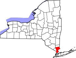
Eastchester is a census-designated place (CDP) in Westchester County, New York, United States. The population was 19,554 at the 2010 census. The Eastchester CDP consists of the Town of Eastchester excluding the villages of Bronxville and Tuckahoe. [2]
According to the United States Census Bureau, the CDP has a total area of 3.5 square miles (9.1 km2), of which 3.3 square miles (8.5 km2) is land and 0.1 square miles (0.26 km2), or 2.90%, is water.
Census | Pop. | Note | %± |
---|---|---|---|
2020 | 20,901 | — | |
U.S. Decennial Census [3] |
As of the census [4] of 2010, there were 19,554 people, 7,687 households, and 5,127 families residing in the CDP. The population density was 5,542.4 inhabitants per square mile (2,139.9/km2). There were 7,919 housing units at an average density of 2,364.3 per square mile (912.9/km2). The racial makeup of the CDP was 90.22% White, 0.94% Black or African American, 0.06% Native American, 6.58% Asian, 0.02% Pacific Islander, 0.94% from other races, and 1.23% from two or more races. Hispanic or Latino of any race were 3.56% of the population.
According to the 2010 population 24.26% are under the age of 18, 56.1% were married couples living together, 8.4% had a female householder with no husband present, and 33.3% were non-families. 30.3% of all households were made up of individuals, and 14.5% had someone living alone who was 65 years of age or older. The average household size was 2.41 and the average family size was 3.04.
In the CDP, the population was spread out, with 22.2% under the age of 18, 4.7% from 18 to 24, 28.8% from 25 to 44, 24.8% from 45 to 64, and 19.5% who were 65 years of age or older. The median age was 42 years. For every 100 females, there were 86.9 males. For every 100 females age 18 and over, there were 82.2 males.
The median income for a household in the CDP was $75,117, and the median income for a family was $96,179. Males had a median income of $66,684 versus $49,117 for females. The per capita income for the CDP was $42,067. About 2.5% of families and 3.6% of the population were below the poverty line, including 3.4% of those under age 18 and 4.9% of those age 65 or over.
North Crossett is a census-designated place (CDP) in Ashley County, Arkansas, United States. Per the 2020 census, the population was 2,756.
Old Mystic is a village and census-designated place (CDP) located in the town of Groton, Connecticut. The population was 3,554 at the 2010 census.
Southeast Arcadia is a census-designated place (CDP) in DeSoto County, Florida, United States. The population was 6,554 at the 2010 census.
Wabasso Beach is a census-designated place (CDP) in Indian River County, Florida, United States. The population was 1,853 at the 2010 census, an increase of 72.4% since 2000. It is part of the Sebastian–Vero Beach Metropolitan Statistical Area.
Andrews is a census-designated place (CDP) in Levy County, Florida, United States. The population was 798 at the 2010 census.
West Chatham is a census-designated place (CDP) in the town of Chatham in Barnstable County, Massachusetts, United States. The population was 1,410 at the 2010 census.
Helena West Side is a census-designated place (CDP) in Lewis and Clark County, Montana, United States. The population was 1,637 at the 2010 census, down from 1,711 at the 2000 census due to annexation of part of the CDP by the city of Helena. It is part of the Helena Micropolitan Statistical Area.
Country Lake Estates is an unincorporated community and census-designated place (CDP) located within Pemberton Township, in Burlington County, New Jersey, United States. As of the 2010 United States Census, the CDP's population was 3,943.
Springdale is an unincorporated community and census-designated place (CDP) located within Cherry Hill Township, in Camden County, New Jersey, United States. As of the 2010 United States Census, the section population was 14,518.
East Norwich is a hamlet and census-designated place (CDP) located within the Town of Oyster Bay in Nassau County, on the North Shore of Long Island, in New York, United States. The population was 2,709 at the 2010 census.
Brewster Hill is a hamlet located in the town of Southeast in Putnam County, New York, United States. As of the 2010 census, the population was 2,089.
Eatons Neck is a hamlet and census-designated place (CDP) in the Town of Huntington in Suffolk County, on the North Shore of Long Island, in New York, United States. The population was 1,406 at the 2010 census.
Brices Creek is an unincorporated area and census-designated place (CDP) in Craven County, North Carolina, United States. The population was 3,073 at the 2010 census. It is part of the New Bern, North Carolina Metropolitan Statistical Area.
Belvedere is a census-designated place (CDP) and suburb of North Augusta in Aiken County, South Carolina, United States. It is part of the Augusta, Georgia metropolitan area. The population was 5,792 at the 2010 census.
Irwin is an unincorporated community and census-designated place (CDP) in Lancaster County, South Carolina, United States. The population was 1,405 at the 2010 census.
Adams is a census-designated place (CDP) located in the town of Adams in Berkshire County, Massachusetts, United States. The population was 5,515 at the 2010 census, out of 8,485 in the entire town of Adams.
Friendship is a hamlet in Allegany County, New York, United States. The population was 1,218 at the 2010 census. The community is the principal settlement in the town of Friendship.
Tonawanda is a census-designated place (CDP) in Erie County, New York, United States. The CDP comprises the town of Tonawanda minus its subsidiary village of Kenmore. As of the 2010 census, the CDP population was 58,144.
Dover-Foxcroft is a census-designated place (CDP) in the town of Dover-Foxcroft in Piscataquis County, Maine, United States. The population was 2,592 at the 2000 census.
Milo is a census-designated place (CDP) in the town of Milo in Piscataquis County, Maine, United States. The population was 1,898 at the 2000 census.