North Salem, New York

Last updated

North Salem, New York
Town of North Salem
Downtown Croton Falls, NY.jpg
Downtown Croton Falls, a hamlet within the town
North Salem, NY Seal.png
Westchester County New York incorporated and unincorporated areas North Salem highlighted.svg
Location of North Salem, New York
Coordinates: 41°19′41″N73°36′47″W / 41.32806°N 73.61306°W / 41.32806; -73.61306
Country United States
State New York
County Westchester
Incorporated1788
Government
  Town SupervisorWarren Lucas (R [1] )
Area
[2]
  Total22.939 sq mi (59.41 km2)
  Land21.369 sq mi (55.35 km2)
  Water1.57 sq mi (4.1 km2)
Elevation
338 ft (103 m)
Population
 (2020)
  Total5,243
  Estimate 
(2021) [3]
5,195
  Density245.4/sq mi (94.72/km2)
Time zone UTC-5 (Eastern (EST))
  Summer (DST) UTC-4 (EDT)
ZIP code
10560
Area code 914
FIPS code 36-53517
GNIS feature ID0979292
Website www.northsalemny.org

North Salem is a town in the northeastern section of Westchester County, New York, United States. The town, incorporated in 1788, is a suburb of New York City, located approximately 50 miles north of Midtown Manhattan. As of the 2020 census, North Salem was recorded as possessing a population of 5,243 people living on a land area of 21.37 square miles. [4]

Contents

History

Prior to the end of the Colonial Era, what would become North Salem and its neighboring town of South Salem were a single municipality, Salem. After the breakout of the American Revolutionary War in 1776, town residents sided with the revolutionary cause. [5]

On Sept. 22, 1780, amidst the war, John Paulding and Isaac Van Wart left from what was later known as the Yerkes Tavern, joined by David Williams. Their expedition resulted in the capture of the British spy Major John André. The foundation of Yerkes (Yerks) Tavern is all that is left of the historic building, once at the intersection of Yerkes Road and Bogtown Road. An historic plaque posted on the site reads:

On this site stood one of North Salem's early taverns. Its proprietor was John Yerkes, who received a license from the town "to operate a tavern or inn for the accommodation and entertainment of travelers" in 1815. Early records indicate that this property was owned by the Smith family prior to this date. [6]

In late May 1784, soon after the end of the American Revolution, Salem split into two towns. What would become known as North Salem was known as Upper Salem for about four years after the split, until an act of the New York State Legislature in 1788 gave the town its modern name. [5]

The 1800 United States Census recorded several hundred enslaved individuals being held in North Salem. [7] New York began operating under a policy of gradual abolition in 1799, with full abolition in 1827; [8] the practice of slavery in North Salem can therefore be estimated to have come to an end sometime between the years 1800 and 1827.

The Great Blizzard of 1888, which impacted communities across the northeastern United States, seriously disrupted agricultural production in North Salem and prevented train movement. It took over a week after the storm to restore roads and trains to operational order. [9]

In the late 1960's, Interstate 684 was extended north from White Plains to the western edge of North Salem; exits in the hamlet of Goldens Bridge and on Hardscrabble road in 1969. This triggered a large population increase in the 1970's. [10]

North Salem's Union Hall was added to the National Register of Historic Places in 1986. [11]

Geography

Putnam County, New York borders North Salem to the north, while the State of Connecticut abuts it to the east. The town itself has a total area of 22.939 square miles (59.41 km2), of which 21.37 square miles (55.3 km2) is land and 1.57 square miles (4.1 km2) is water. [12] Climatically, the town is in plant hardiness zone 6b on the U.S.D.A. scale, meaning that in extreme circumstances, winter temperature lows could reach −5 °F (−21 °C). [13] [14]

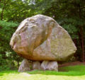
A geographic curiosity of North Salem is the so-called Standing Rock, a granite boulder sitting on several smaller stones. Since the boulder is not consistent with the geographic surroundings, it has been hypothesized that the rock was deposited by glaciers during the Last Ice Age, [5] although others argue that it may have been moved and placed by Vikings or Native Americans. [15]

Demographics

Historical population
CensusPop.Note
1790 1,058
1820 1,480
1830 1,276−13.8%
1840 1,161−9.0%
1850 1,33515.0%
1860 1,49712.1%
1870 1,75417.2%
1880 1,693−3.5%
1890 1,7302.2%
1900 1,133−34.5%
1910 1,25811.0%
1920 934−25.8%
1930 1,12820.8%
1940 1,1945.9%
1950 1,62235.8%
1960 2,34544.6%
1970 3,82863.2%
1980 4,56919.4%
1990 4,7253.4%
2000 5,1739.5%
2010 5,104−1.3%
2020 5,2432.7%
2021 (est.)5,195 [3] −0.9%
U.S. Decennial Census [16]

In 2011, the average income for a household in the town was $157,258, with an average net worth of $1,300,058. The median house value in 2009 was $772,817. The per capita income for the town was $59,403. About 1.5% of families and 2.0% of the population were below the poverty line, including 2.2% of those under age 18 and none of those age 65 or over. As of the census [17] of 2000, there were 5,173 people, 1,764 households, and 1,374 families residing in the town. The population density was 241.5 inhabitants per square mile (93.2/km2). There were 1,979 housing units at an average density of 92.4 per square mile (35.7/km2). The racial makeup of the town was 95.44% White, 0.75% African American, 0.08% Native American, 0.97% Asian, 1.12% from other races, and 1.64% from two or more races. Hispanic or Latino of any race were 3.65% of the population.

There were 1,764 households, out of which 39.2% had children under the age of 18 living with them, 68.1% were married couples living together, 7.5% had a female householder with no husband present, and 22.1% were non-families. 17.5% of all households were made up of individuals, and 5.3% had someone living alone who was 65 years of age or older. The average household size was 2.80 and the average family size was 3.17. In the town, the population was spread out, with 26.2% under the age of 18, 4.4% from 18 to 24, 28.5% from 25 to 44, 27.0% from 45 to 64, and 13.9% who were 65 years of age or older. The median age was 40 years. For every 100 females, there were 91.6 males. For every 100 females age 18 and over, there were 87.4 males.

Hamlets

Croton River, near the hamlet of Purdys Croton River at Purdys jeh.jpg
Croton River, near the hamlet of Purdys

Education

North Salem Middle School/High School is located on June Road in North Salem. [19] In 2004, the high school was distinguished as a Blue Ribbon School for high levels of educational achievement by the United States Department of Education. [20]

Pequenakonck Elementary School, located 0.3 miles (0.5 km) away from the middle school/high school, serves grades K-5. The middle school, which shares the same building as the high school, serves grades 6–8. This school is particularly small, with about 90 children on average per grade, making the student to faculty ratio relatively small.

Town government

North Salem's town government consists of a town supervisor and four town board members. The supervisor serves a two-year term, and the board members serve four-year terms. Elections are staggered such that in any given election year, the supervisor and two board members' seats will be up for election. [21]

North Salem government
Position electedNameYear first electedPolitical affiliationYear next up for election
Town SupervisorWarren Lucas2009R2025
Town Council MemberPeter Kamenstein2009R2025
Town Council MemberKatherine Daniels2020D2027
Town Council MemberBrent Golisano2015R2027
Town Council MemberMartin Aronchick2011*D2025

*Aronchick first won his seat in 2011, lost it in 2015 to Lisa Douglas, and won a seat back in 2016 in a special election.

The town is part of New York's Eighteenth Congressional District, [22] represented by Mike Lawler, a Republican. First elected in 2009, Warren Lucas, a Republican, serves as North Salem's Town Supervisor. [23]

Notable people

See also

Related Research Articles

<span class="mw-page-title-main">New Scotland, New York</span> Town in New York, United States

New Scotland is a town in Albany County, New York, United States. The population was 9,096 at the 2020 census.

Freedom is a town in Cattaraugus County, New York, United States. The population was 2,244 at the 2021 census. The town is in the northeast corner of Cattaraugus County.

<span class="mw-page-title-main">Smithville, New York</span> Town in New York, United States

Smithville is a town in Chenango County, New York, United States. The population was 1,330 at the 2010 census. The town is at the western border of Chenango County, west of the city of Norwich.

<span class="mw-page-title-main">Chili, New York</span> Town in New York, United States

Chili is a town in Monroe County, New York, United States. The population was 29,123 at the 2020 census. It is a suburb of the city of Rochester.

<span class="mw-page-title-main">Gates, New York</span> Town in New York, United States

Gates is a town in Monroe County, New York, United States. The town is named after General Horatio Gates. The population was 28,400 at the 2010 census. Gates and North Gates are census-designated places located within the town's boundaries. It is a suburb of nearby Rochester, New York.

<span class="mw-page-title-main">Pompey, New York</span> Town in New York, United States

Pompey is a town in the southeast part of Onondaga County, New York. As of the 2020 Census, the population was 7,080. The town was named after the Roman general and political leader Pompey by a late 18th-century clerk interested in the Classics in the new federal republic.

<span class="mw-page-title-main">Putnam Valley, New York</span> Town in New York, United States

Putnam Valley is a town in Putnam County, New York, United States. The population was 11,809 at the 2010 census. Its location is northeast of New York City, in the southwestern part of Putnam County. Putnam Valley calls itself the "Town of Lakes".

<span class="mw-page-title-main">Cortlandt, New York</span> Town in New York, United States

Cortlandt is a town in Westchester County, New York, United States, located at the northwestern edge of the county, at the eastern terminus of the Bear Mountain Bridge. The town includes the villages of Buchanan and Croton-on-Hudson.

<span class="mw-page-title-main">Goldens Bridge, New York</span> Census-designated place in New York, United States

Goldens Bridge is a hamlet and census-designated place (CDP) in the town of Lewisboro in Westchester County, New York, United States. The population was 1,630 at the 2010 census.

<span class="mw-page-title-main">Greenburgh, New York</span> Town in New York, United States

Greenburgh is a town in western Westchester County, New York. The population was 95,397 at the time of the 2020 census.

<span class="mw-page-title-main">Lewisboro, New York</span> Town in New York, United States

Lewisboro is a town in Westchester County, New York, United States. The population was 12,411 at the 2010 census. The town is named after John Lewis, an early settler. Lewisboro is a suburb of New York City.

<span class="mw-page-title-main">Mount Pleasant, New York</span> Town in New York, United States

Mount Pleasant is a town in Westchester County, New York, United States, in the New York metropolitan area. As of the 2020 census, the town population was 44,436. The hamlets of Valhalla, Hawthorne, Pocantico Hills, and Thornwood, and the villages of Pleasantville, Sleepy Hollow, and a small portion of Briarcliff Manor lie within the town.

<span class="mw-page-title-main">New Castle, New York</span> Town in New York, United States

New Castle is a town in Westchester County, New York, United States. The population was 18,311 in the 2020 United States census, an increase over 17,569 at the 2010 census. It includes the hamlets of Chappaqua and Millwood.

<span class="mw-page-title-main">North Castle, New York</span> Town in New York, United States

North Castle is a town in Westchester County, New York, United States. The population was 12,408 at the 2020 census. It has three hamlets: Armonk, Banksville, and North White Plains.

<span class="mw-page-title-main">Somers, New York</span> Town in New York, United States

Somers is a town located in northern Westchester County, New York, United States. As of the 2010 census, the town had a population of 20,434. The nearby Metro-North Commuter Railroad provides service to Grand Central Terminal in Manhattan with an average commute time of 65 to 75 minutes from stations at Purdys, Goldens Bridge, Croton Falls, and Katonah.

<span class="mw-page-title-main">Valhalla, New York</span> Hamlet in New York, United States

Valhalla is a hamlet and census-designated place (CDP) within the town of Mount Pleasant, in Westchester County, New York, United States, in the New York City metropolitan area. Its population was 3,162 at the 2010 U.S. Census. The name was inspired by a fan of the composer Richard Wagner, and the hamlet is known both as the home of the primary hospital campus of Westchester Medical Center and New York Medical College and as the burial place of numerous noted people. Valhalla is the realm of the gods in Norse mythology.

<span class="mw-page-title-main">Poughkeepsie (town), New York</span> Town in New York, United States

Poughkeepsie, officially the Town of Poughkeepsie, is a town in Dutchess County, New York, United States. As of the 2020 United States Census, the population was 45,471. The name is derived from the native term Uppuqui meaning "lodge-covered", plus ipis meaning "little water", plus ing meaning "place", all of which translates to "the reed-covered lodge by the little water place", or Uppuqui-ipis-ing. This later evolved into Apokeepsing, then into Poughkeepsing, and finally Poughkeepsie.

Leicester is a town in Livingston County, New York, United States. The population was 2,200 at the 2010 census. The town is named after Leicester Phelps, an early inhabitant.

<span class="mw-page-title-main">Salem (hamlet), New York</span> Hamlet and CDP in New York, United States

Salem is a hamlet located in the town of Salem in Washington County, New York, United States. It is part of the Glens Falls Metropolitan Statistical Area. The population was 946 at the 2010 census.

<span class="mw-page-title-main">Ossining, New York</span> Town in New York, United States

Ossining is a town located along the Hudson River in Westchester County, New York. The population was 40,061 at the time of the 2020 census. It contains two villages, the Village of Ossining and part of Briarcliff Manor, the rest of which is located in the Town of Mount Pleasant. Ossining is the location of Sing Sing maximum-security prison.

References

  1. Pacchiana, Katherine (August 24, 2011). "North Salem: Who is Running For What?". The Daily Voice. Retrieved October 5, 2015. Republican incumbent Warren Lucas will run unopposed for supervisor
  2. "2022 U.S. Gazetteer Files".
  3. 1 2 "Population and Housing Unit Estimates" . Retrieved June 9, 2017.
  4. "North Salem 2020 Census Quickfacts". United States Census Bureau. July 1, 2021.
  5. 1 2 3 Scharf, John Thomas (1886). History of Westchester County: New York, Including Morrisania, Kings Bridge, and West Farms, which Have Been Annexed to New York City. L. E. Preston & Company.
  6. Yerkes Tavern, Map the Past
  7. North Salem Census of 1800. United States Census Bureau, 1800.
  8. Harper, Douglas (2003). "Emancipation in New York". Slavery in the North
  9. "North Salem History Nuggets". North Salem Historical Society. Retrieved April 19, 2023.
  10. "Interstate 684 (New York)". www.nycroads.com. Retrieved March 24, 2024.
  11. 1 2 3 "National Register Information System". National Register of Historic Places . National Park Service. March 13, 2009.
  12. "2022 Gazetteer – New York State". United States Census Bureau Gazetteer. 2022.
  13. "PRISM Climate Data for Lower 48". PRISM Climate Group.
  14. "USDA Plant Hardiness Zone Map". planthardiness.ars.usda.gov. Retrieved August 17, 2023.
  15. "Native American Propped Boulders". nativestones.com. Retrieved April 9, 2021.
  16. "Census of Population and Housing". Census.gov. Retrieved June 4, 2015.
  17. "U.S. Census website". United States Census Bureau . Retrieved January 31, 2008.
  18. "X-Men Xavier Institute mansion appears on Google Maps". BBC News. November 14, 2014. Retrieved September 10, 2021.
  19. "northsalemschools" . Retrieved July 25, 2011.
  20. "northsalemschools" . Retrieved July 25, 2016.
  21. "Town Board > Home | The Town of North Salem, NY". www.northsalemny.org. Retrieved February 17, 2018.
  22. "New York Congressional Districts Map" (PDF). US Census Bureau.
  23. "Town Board | North Salem, NY". www.northsalemny.org. Retrieved April 9, 2021.
  24. "Fanny Crosby Birthplace Historical Marker – Adventures Around Putnam".
  25. Charles, Eleanor (May 16, 1982). "WESTCHESTER GUIDE; PAUL NEWMAN'S PLACE". The New York Times. ISSN   0362-4331 . Retrieved January 17, 2023.
  26. Cary, Bill (September 6, 2013). "Dick Button's garden glory: Open Days opened over weekend". lohud.com. Gannett. Retrieved September 10, 2013.
  27. 1 2 3 "Westchester Magazine" . Retrieved July 25, 2011.
  28. "Happy Birthday To North Salem's Steven Lawrence Rattner". North Salem Daily Voice. July 5, 2014.
  29. Andrews, Suzanna. "Larry Fink's $12 Trillion Shadow". Vanity Fair.
  30. 1 2 "A MUSICAL VALENTINE FOR NORTH SALEM, A PERFORMANCE BY PIANIST ROBBIE KONDOR AND VOCALIST EMILY BINDIGER!". Macaroni Kid North Westchester.
  31. Phoning Home. University of South Carolina Press, 2014
  32. "North Salem Equine Rescue Tastes 'Victory'". TAPinto.

Commons-logo.svg Media related to North Salem, New York at Wikimedia Commons