Somerset County, New Jersey

Last updated

Somerset County
Somerset County Courthouse, Somerville, NJ - historic, looking northeast.jpg
Flag of Somerset County, New Jersey.gif
Seal of Somerset County, New Jersey.svg
Map of New Jersey highlighting Somerset County.svg
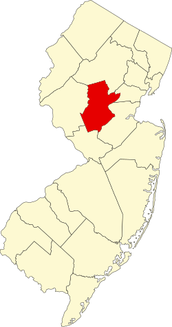
Location within the U.S. state of New Jersey
New Jersey in United States.svg
New Jersey's location within the U.S.
Coordinates: 40°34′N74°37′W / 40.56°N 74.61°W / 40.56; -74.61
CountryFlag of the United States.svg United States
StateFlag of New Jersey.svg  New Jersey
FoundedMay 14, 1688 [1]
Named for English county of Somerset [2]
Seat Somerville [3]
Largest municipality Franklin Township (population)
Hillsborough Township (area)
Government
  Commissioner directorShanel Robinson (D, term ends December 31, 2023)
Area
[4]
  Total304.95 sq mi (789.8 km2)
  Land301.87 sq mi (781.8 km2)
  Water3.09 sq mi (8.0 km2)  1.00%
Population
 (2020) [5] [6]
  Total345,361
  Estimate 
(2023) [5] [7]
348,842
  Density1,144.3/sq mi (441.8/km2)
Congressional districts 7th, 12th
Website www.co.somerset.nj.us
Somerset County, New Jersey
Interactive map of Somerset County, New Jersey

Somerset County is a county located in the north-central part of the U.S. state of New Jersey. As of the 2020 census, the county was the state's 13th-most-populous county, [8] with a population of 345,361, [5] [6] its highest decennial count ever and an increase of 21,917 (+6.8%) from the 2010 census count of 323,444. [9] Somerset County constitutes part of the New York metropolitan area. Its county seat is Somerville. [3] The most populous place in the county was Franklin Township, with 68,364 residents at the time of the 2020 census, [5] while Hillsborough Township, with 55.00 square miles (142.4 km2), covered the largest total area of any municipality. [10] The county is part of the Central Jersey region of the state. [11] [12]

Contents

In 2015, Somerset County had a per capita personal income of $86,468, the second highest in New Jersey and ranked 25th of 3,113 counties in the United States. [13] [14] Somerset County, as of the 2000 Census, was the seventh wealthiest county in the United States by median household income at $76,933 (third in New Jersey behind Hunterdon County at $79,888 and Morris County at $77,340), fourth in median family income at $90,655 (second in New Jersey behind Hunterdon County at $91,050) and ranked seventh by per capita income at $37,970 (highest in New Jersey). [15] The Bureau of Economic Analysis ranked the county as having the 11th-highest per capita income of all 3,113 counties in the United States (and the highest in New Jersey) as of 2009. [16]

In 2012, 49.8 percent of Somerset County residents were college graduates, the highest percentage in the state. [17] Somerset County was recently ranked number 3 of 21 NJ counties as one of the healthiest counties in New Jersey, according to an annual report by County Health Rankings and Roadmaps. [18] Somerset County was created on May 14, 1688, from portions of Middlesex County. [1]

History

Etymology

Somerset County is one of America's oldest counties, and is named after the English county of Somerset.

History

The area was first settled in 1681, in the vicinity of Bound Brook, and the county was established by charter on May 22, 1688. Most of the early residents were Dutch.

During the American Revolutionary War, General George Washington and his troops marched through the county on several occasions and slept in many of the homes located throughout the area. Somerset County also played an important part during both World War I and World War II. Weapons depots were established here, and factories manufactured the army's woolen blankets.

For much of its history, Somerset County was primarily an agricultural county. In the late 19th century, the Somerset Hills area of Somerset County became a popular area for country homes built by wealthy industrialists. Into the 21st century, the area is still the home of wealthy businessmen. [19]

In 1917, Somerset County, in cooperation with Rutgers University, hired its first agricultural agent to connect local farmers with expert advice. The Rutgers Cooperative Extension of Somerset County, located in Bridgewater, serves residents in the areas of agriculture and natural resources, 4-H youth development, and family and community health sciences. [20]

In the 1960s, townships that were once exclusively agricultural were quickly developed as suburban residential communities. Examples include Bridgewater Township [21] and the Watchung Hills communities of Watchung, Green Brook and Warren Township. [22] [23] [24] This growth was aided by the development of the county's very strong pharmaceutical and technology presence. Warren Township used to be considered "the greenest place in New Jersey." [22] More recently, there has been an influx of New York City commuters who use NJ Transit's Raritan Valley Line and Gladstone Branch or use Interstate 78.

In 1996, Nicholas L. Bissell Jr., then county prosecutor, was charged with embezzlement, tax fraud, and abuse of power. He fled to Laughlin, Nevada, near Las Vegas, and killed himself when the federal authorities attempted to arrest him. [25]

Geography

Somerville, New Jersey
Climate chart (explanation)
J
F
M
A
M
J
J
A
S
O
N
D
 
 
3.6
 
 
38
18
 
 
2.8
 
 
41
20
 
 
3.9
 
 
50
27
 
 
4.1
 
 
61
36
 
 
4.3
 
 
72
46
 
 
4.4
 
 
80
56
 
 
4.8
 
 
85
61
 
 
4
 
 
83
60
 
 
4.3
 
 
76
52
 
 
4.2
 
 
64
40
 
 
3.6
 
 
54
31
 
 
3.8
 
 
42
23
Average max. and min. temperatures in °F
Precipitation totals in inches
Source: The Weather Channel [26]
Metric conversion
J
F
M
A
M
J
J
A
S
O
N
D
 
 
91
 
 
3
−8
 
 
72
 
 
5
−7
 
 
100
 
 
10
−3
 
 
104
 
 
16
2
 
 
110
 
 
22
8
 
 
110
 
 
27
13
 
 
123
 
 
29
16
 
 
101
 
 
28
16
 
 
108
 
 
24
11
 
 
107
 
 
18
4
 
 
91
 
 
12
−1
 
 
98
 
 
6
−5
Average max. and min. temperatures in °C
Precipitation totals in mm

According to the U.S. Census Bureau, as of the 2020 Census, the county had a total area of 304.95 square miles (789.8 km2), of which 301.87 square miles (781.8 km2) was land (99%) and 3.09 square miles (8.0 km2) was water (1%). [4]

The high point is on Mine Mountain in Bernardsville, at approximately 860 feet (260 m) above sea level. [27] The lowest point is just above sea level on the Raritan River at the Middlesex County line.

Climate and weather

In recent years, average temperatures in the county seat of Somerville have ranged from a low of 18 °F (−8 °C) in January to a high of 85 °F (29 °C) in July, although a record low of −16 °F (−27 °C) was recorded in January 1984 and a record high of 105 °F (41 °C) was recorded in August 1955. Average monthly precipitation ranged from 2.84 inches (72 mm) in February to 4.83 inches (123 mm) in July. [26] The county has a humid continental climate which is hot-summer (Dfa) except on Mine Mountain west of Bernardsville where it is warm-summer (Dfb).[ citation needed ]

Demographics

Historical population
CensusPop.Note
1790 12,296
1800 12,8154.2%
1810 14,72514.9%
1820 16,50612.1%
1830 17,6897.2%
1840 17,455*−1.3%
1850 19,69212.8%
1860 22,05712.0%
1870 23,5106.6%
1880 27,16215.5%
1890 28,3114.2%
1900 32,94816.4%
1910 38,82017.8%
1920 47,99123.6%
1930 65,13235.7%
1940 74,39014.2%
1950 99,05233.2%
1960 143,91345.3%
1970 198,37237.8%
1980 203,1292.4%
1990 240,27918.3%
2000 297,49023.8%
2010 323,4448.7%
2020 345,3616.8%
2023 (est.)348,842 [5] [7] 1.0%
Historical sources: 1790–1990 [28]
1970-2010 [10] 2010 [9] 2020 [5] [6]
* = Lost territory in previous decade.

2020 census

As of the 2020 United States census, the county's had 345,361 people, 122,606 households, and 88,540 families. [29] The population density was 1,144.3 inhabitants per square mile (441.8/km2). There were 131,822 housing units at an average density of 436.77 per square mile (168.6/km2). [30] The racial makeup was 61.0% White, 10.0% African American, 0.2% Native American, 18.5% Asian, and 2.2% from two or more races. Hispanic or Latino people of any race were 15.2% of the population. [31]

Of the 122,606 households, of which 21.5% had children under the age of 18 living with them, 59.3% were married couples living together, 9.6% had a female householder with no husband present, 3.3% had a male householder with no wife present and 27.8% were non-families, and 9.3% had someone living alone who was 65 years of age or older. The average household size was 2.65 and the average family size was 3.16.

About 21.5% of the population was under age 18, 8.4% was from age 18 to 24, 36.3% was from age 15 to 44, and 16.2% was age 65 or older. The median age was 42.2 years. The gender makeup was 49.2% male and 50.8% female. For every 100 females, there were 96.8 males. [32]

The median household income was $111,587, and the median family income was $135,129. About 5.7% of the population were below the poverty line, including 8.8% of those under age 18 and 6.1% of those age 65 or over. [33] [34]

2010 census

The 2010 United States census counted 323,444 people, 117,759 households, and 84,669 families in the county. The population density was 1,071.7 per square mile (413.8/km2). There were 123,127 housing units at an average density of 408 per square mile (158/km2). The racial makeup was 70.06% (226,608) White, 8.95% (28,943) Black or African American, 0.17% (556) Native American, 14.11% (45,650) Asian, 0.03% (94) Pacific Islander, 4.13% (13,360) from other races, and 2.55% (8,233) from two or more races. Hispanic or Latino people of any race were 13.01% (42,091) of the population. [9]

Of the 117,759 households, 35.9% had children under the age of 18; 58.8% were married couples living together; 9.5% had a female householder with no husband present and 28.1% were non-families. Of all households, 23.3% were made up of individuals and 8.5% had someone living alone who was 65 years of age or older. The average household size was 2.71 and the average family size was 3.22. [9]

25% of the population were under the age of 18, 6.5% from 18 to 24, 26.4% from 25 to 44, 29.8% from 45 to 64, and 12.4% who were 65 years of age or older. The median age was 40.2 years. For every 100 females, the population had 95.1 males. For every 100 females ages 18 and older there were 91.8 males. [9]

Economy

The Bureau of Economic Analysis calculated that the county's gross domestic product was $39.8 billion in 2021, which was ranked sixth in the state and was a 5.6% increase from the prior year. [35]

Based on IRS data for the 2004 tax year, Somerset County taxpayers had the ninth-highest average federal income tax liability per return in the country. Average tax liability was $16,502, representing 16.8% of adjusted gross income. [36]

Parks and recreation

The Somerset Patriots are a professional baseball team that plays at the 6,100-seat TD Bank Ballpark, located on the border of Bridgewater and Bound Brook. They played in the independent Atlantic League of Professional Baseball until they became the Double-A affiliate of the New York Yankees in 2021. [37]

A walking trail in Basking Ridge Basking Ridge, New Jersey.jpg
A walking trail in Basking Ridge

Somerset County parks are under the administration of the Somerset County Parks Commission. [38] General parks are Natirar, Duke Island Park, Lord Stirling Park (part of the Great Swamp National Wildlife Refuge), Colonial Park, North Branch Park, Skillman Park, East County Park and a park in development called Raritan River Greenway. Leonard J. Buck Garden is a botanical garden of the county. In addition, the Commission manages natural parks such as the Washington Valley Park (with biking and hiking trails) and the Sourland Mountain Preserve (hiking and mountain biking trails). [38]

The Sourland Mountain Preserve in Hillsborough The Sourland Mountain Preserve, Hillsborough, New Jersey, USA June 2012 - panoramio (3).jpg
The Sourland Mountain Preserve in Hillsborough

The southeastern portion of Somerset County in Franklin Township also includes the Delaware and Raritan Canal State Park, which provides hiking, biking and boating. [39]

The Parks Commission operates five public golf courses. [38] Trump National Golf Club in Bedminster, an exclusive golf club owned by Donald Trump, [40] that he used as a Summer White House during his presidency. [41]

Government

County government

Somerset County is governed by a five-member Board of County Commissioners, whose members are elected at-large to three-year terms of office on a staggered basis, with one or two seats coming up for election each year. At an annual reorganization meeting held on the first Friday of January, the board selects a Director and Deputy Director from among its members. [42] In 2016, commissioners (then known as freeholders) were paid $21,902 and the commissioner director was paid an annual salary of $22,902. [43] The Commissioners employ a full-time County Administrator who manages the day-to-day operations of the county government. The County Administrator is Colleen Mahr. [44] The Clerk of the County Commissioners oversees the work of their offices. Department heads are appointed in accordance with statute and by resolution of the board. Somerset County currently has approximately 1,100 full-time and 130 part-time employees in 52 divisions (including the Library System). [45]

As of 2024, Somerset County's County Commissioners are (with terms for director and deputy director ending every December 31st): [46] [47] [48] [49] [50] [51]

CommissionerParty, residence, term
Director Shanel Robinson D, Franklin Township, 2024 [52]
Deputy Director Sara SooyD, Bernards Township, 2024 [53]
Paul DrakeD, Hillsborough Township, 2026 [54]
Melonie MaranoD, Green Brook Township, 2025 [55]
Douglas SingleterryD, North Plainfield, 2026 [56]

Democrats captured their first countywide office in 2018 since 1979, and in 2019 won a majority on the county commission for the first time since 1964. Republicans have not won a county-wide office since 2017. [57] Pursuant to Article VII Section II of the New Jersey State Constitution, each county in New Jersey is required to have three elected administrative officials known as "constitutional officers." These officers are the County Clerk and County Surrogate (both elected for five-year terms of office) and the County Sheriff (elected for a three-year term). [58] Constitutional officers, elected on a countywide basis, are: [48]

TitleRepresentative
County ClerkSteve Peter (D, Somerville, 2027) [59] [60]
SheriffDarrin Russo (D, Franklin Township, 2025) [61] [62]
SurrogateBernice "Tina" Jalloh (D, Franklin Township, 2025) [63] [64]

The Somerset County Prosecutor is Michael H. Robertson of the Basking Ridge section of Bernards Township, who was nominated by the Governor of New Jersey Chris Christie in September 2016. [65] [66] Somerset County is a part of Vicinage 13 of the New Jersey Superior Court (along with Hunterdon County and Warren County), which is seated at the Somerset County Courthouse in Somerville; the Assignment Judge for Vicinage 15 is Thomas C. Miller. [67]

Federal representatives

The 7th and 12th Congressional Districts cover the county. [68] [69] For the 118th United States Congress , New Jersey's 7th congressional district is represented by Thomas Kean Jr. ( R , Westfield ). [70] For the 118th United States Congress , New Jersey's 12th congressional district is represented by Bonnie Watson Coleman ( D , Ewing Township ). [71] [72]

State representatives

The 21 municipalities of Somerset County are represented by five legislative districts.

DistrictSenator [73] Assembly [73] Municipalities
16th Andrew Zwicker (D) Mitchelle Drulis (D)

Roy Freiman (D)

Branchburg, Hillsborough, Millstone Borough, Montgomery, and Rocky Hill. The remainder of this district covers portions of Hunterdon County, Mercer County, and Middlesex County.
17th Bob Smith (D) Kevin Egan (D)

Joseph Danielsen(D)

Franklin Township and South Bound Brook. The remainder of this district covers portions of Middlesex County.
21st Jon Bramnick (R) Michele Matsikoudis (R)

Nancy Munoz (R)

Bernards Township, Bernardsville, Far Hills, Green Brook, Peapack-Gladstone, Warren Township, and Watchung. The remainder of this district covers portions of Morris County, Middlesex County and Union County.
22nd Nicholas Scutari (D) James J. Kennedy (D)

Linda S. Carter (D)

North Plainfield. The remainder of this district covers portions of Union County.
23rd Michael J. Doherty (R) John DiMaio (R)

Erik Peterson (R)

Bedminster, Bound Brook, Bridgewater, Manville, Raritan Borough, and Somerville. The remainder of this district covers Huntderton County and Warren County.

Politics

As of October 1, 2021, there were a total of 262,410 registered voters in Somerset County, of whom 92,921 (35.4%) were registered as Democrats, 66,455 (25.3%) were registered as Republicans and 100,367 (38.2%) were registered as unaffiliated. There were 2,667 voters (1.0%) registered to other parties. [74] Among the county's 2010 Census population, 67.1% were registered to vote, including 75.% of those ages 18 and over. [75] [76]

In the 2008, Barack Obama became the first Democratic presidential nominee to carry the county since Lyndon Johnson in 1964, and only the second since 1936. Obama won Somerset by a 6.1% margin over John McCain, with Obama carrying the state by 15.5% over McCain. [77] Somerset's growing Democratic trend at the presidential level has largely been spurred by the rapid growth of the overwhelmingly Democratic Franklin Township in the county's southeast corner. In the 2012 presidential election, the county was carried by Barack Obama, winning 52.8% of the vote to Mitt Romney's 47.2%, a 5.6% gap that represented a 0.5% drop off for Obama from his 2008 margin of victory in the county. [78] [79] In 2016, the county voted as Democratic as the state, and in 2020, Joe Biden won the largest share of the vote in the county for a Democrat since 1964, as the county voted more Democratic than the state as a whole for the first time since 1912.

United States presidential election results for Somerset County, New Jersey [80]
Year Republican Democratic Third party
No.%No.%No.%
2020 71,99638.52%111,17359.49%3,7221.99%
2016 65,50541.70%85,68954.55%5,8983.75%
2012 66,60346.52%74,59252.10%1,9851.39%
2008 70,08546.28%79,32152.38%2,0241.34%
2004 72,50851.69%66,47647.39%1,2950.92%
2000 59,72549.61%56,23246.71%4,4203.67%
1996 51,86945.93%50,67344.87%10,3879.20%
1992 56,04446.39%42,86735.48%21,90218.13%
1988 67,65863.71%37,40635.22%1,1291.06%
1984 66,30366.77%31,92432.15%1,0691.08%
1980 52,59157.21%29,47032.06%9,86710.73%
1976 51,26057.15%36,25840.43%2,1732.42%
1972 56,52466.03%26,53731.00%2,5442.97%
1968 42,45954.11%27,58035.14%8,43610.75%
1964 28,41639.32%43,65960.41%1950.27%
1960 36,20055.81%28,48943.92%1740.27%
1956 37,93071.85%14,52927.52%3300.63%
1952 31,23963.34%18,00736.51%740.15%
1948 22,03459.77%14,10438.26%7241.96%
1944 20,26658.29%14,46741.61%370.11%
1940 20,16954.87%16,49044.86%960.26%
1936 15,80649.57%15,98750.14%940.29%
1932 15,31754.18%12,34543.66%6112.16%
1928 16,38666.66%8,12033.03%740.30%
1924 12,98671.12%4,14322.69%1,1316.19%
1920 10,96271.02%4,19227.16%2811.82%
1916 4,70755.70%3,65343.23%911.08%
1912 2,06827.94%3,14642.50%2,18829.56%
1908 5,04559.46%3,26938.53%1702.00%
1904 4,63357.57%3,19539.70%2192.72%
1900 4,43756.32%3,18440.42%2573.26%
1896 4,38860.18%2,60835.77%2954.05%

In the 2009 gubernatorial election, Republican Chris Christie received 56% of the vote, defeating Democrat Jon Corzine, who received around 34%. In the 2013 gubernatorial election, Republican Governor Chris Christie received 67.6% (58,981 votes) to Democrat Barbara Buono's 30.8% (26,913 votes). In the 2017 gubernatorial election, Republican Kim Guadagno received 47.9% of the vote (44,231 ballots cast) to Democrat Phil Murphy with 49.8% (45,935 votes), marking the first Democratic win in the county since 1989. [81] In the 2021 gubernatorial election, Republican Jack Ciattarelli received 47.7% of the vote (54,264 ballots cast) to Democrat Phil Murphy's 51.5% (58,585 votes), this made Somerset, along with neighboring Hunterdon, the only county to shift to the left in this election, despite Ciattarelli representing the county in the state assembly.

Gubernatorial election results
Gubernatorial elections results [82]
Year Republican Democratic
2021 47.7% 54,26451.5%58,585
2017 47.9% 44,23149.8%45,935
2013 67.6% 58,98130.8% 26,913
2009 56.2% 57,48134.3% 35,089
2005 52.7%49,40643.3% 40,459
2001 52.2%44,81545.6% 39,110
1997 57.3% 51,46532.4% 29,089
1993 59.3%38.6%
1989 47.1% 34,81550.5% 37,159
1985 75.6% 44,50223.1% 13,601
1981 62.5%43,69735.9% 25,121
1977 56.1%40,16440.9% 29,286
1973 32.9% 20,93362.7% 39,864

Education

School districts

School districts include: [83] [84] [85] [86]

K-12
Secondary
Elementary

Colleges and universities

Somerset County is home to two colleges:

Alma White College (which operated from 1921 to 1978) was a private college located in Zarephath. [90] Beginning in 1931 the college operated WAWZ 1380 on the AM radio dial. The station continued to 1984 after the school closed. The building is now occupied by Somerset Christian College.

Private schools

Private schools in the county include Gill St. Bernard's School (in Gladstone), Immaculata High School (Somerville), Mount St. Mary Academy, Watchung), Pingry School, Martinsville), Purnell School, Pottersville) and *Rutgers Preparatory School (Somerset). [91]

Somerset Hills Learning Institute, founded in 1998 and located in Bedminster Township, educates children on the autism spectrum by utilizing the principles of applied behavior analysis. [92] In 2024, a local ShopRite store started selleing salads grown by and packed by students in the school's hydroponics career training program. [93]

Municipalities

Index map of Somerset County municipalities (click to see index key) Somerset County, New Jersey Municipalities.png
Index map of Somerset County municipalities (click to see index key)
Somerset County, New Jersey
Interactive map of municipalities in Somerset County.

The 21 municipalities in Somerset County (with 2010 Census data for population, housing units, and area) are listed below. [94] Other unincorporated communities in the county are listed alongside their parent municipality (or municipalities, as the case may be). These areas include census-designated places (CDPs), which the United States Census Bureau created for enumeration purposes within a township. [10] Other communities, historical areas, unincorporated areas, and enclaves that exist within a municipality are also listed.

Municipality
(with map key)
Map keyMun.
type
Pop.Housing
units
Total
area
Water
area
Land
area
Pop.
density
Housing
density
School
district
Communities [95]
Bedminster Township 21township8,0674,34926.300.2226.08313.1166.8 Somerset Hills (9-12) (S/R)
Bedminster Township (PK-8)
Lamington
Pluckemin
Pottersville
Bernards Township 20township26,65210,10324.060.1323.931,113.6422.1 Bernards Township Basking Ridge
Liberty Corner
Lyons
Bernardsville 1borough7,7072,87112.980.0812.91597.2222.5 Somerset Hills
Bound Brook 6borough10,4023,8161.690.041.666,269.62,300.0 Bound Brook
Branchburg Township 16township14,4595,41920.280.2420.04721.4270.4 Somerville (9-12) (S/R)
Branchburg (PK-8)
Neshanic Station
North Branch
Bridgewater Township 17township44,46416,65732.510.4732.041,387.9519.9 Bridgewater-Raritan Bradley Gardens CDP (14,206)
Finderne CDP (5,600)
Green Knoll CDP (6,200)
Martinsville CDP (11,980)
Far Hills 3borough9194184.880.084.80191.687.1 Somerset Hills
Franklin Township 14township62,30024,42646.850.7046.151,350.0529.3 Franklin Township Blackwells Mills CDP (803)
Clyde CDP (213)
East Franklin CDP (8,669)
East Millstone CDP (579)
East Rocky Hill CDP (469)
Franklin Center CDP (4,460)
Franklin Park CDP (13,295)
Griggstown CDP (819)
Kingston CDP (part; 271)
Middlebush CDP (2,326)
Pleasant Plains CDP (922)
Rockingham
Six Mile Run CDP (3,184)
Somerset CDP (22,083)
Ten Mile Run CDP (1,959)
Voorhees CDP (976)
Weston CDP (1,235)
Zarephath CDP (37)
Green Brook Township 19township7,2032,4484.480.014.471,610.5547.3 Watchung Hills (9-12)
Green Brook (PK-8)
Hillsborough Township 15township38,30314,03055.000.4754.54702.3257.3 Hillsborough Amwell
Cloverhill
Flagtown
Neshanic
South Branch
Zion
Manville 8borough10,3444,2772.450.092.364,382.01,811.9 Manville
Millstone 11borough4181670.760.020.74566.5226.3 Hillsborough (S/R)
Montgomery Township 13township22,2547,90232.480.1732.31688.8244.6 Montgomery Amwell
Belle Mead CDP (216)
Blawenburg CDP (280)
Dutchtown
Harlingen CDP (297)
Skillman CDP (242)
Stoutsburg
Zion
North Plainfield 5borough21,9367,8482.810.012.797,850.02,808.5 North Plainfield
Peapack-Gladstone 2borough2,5829495.850.045.81444.5163.4 Somerset Hills Gladstone
Raritan 10borough6,8812,8472.040.041.993,452.21,428.3 Bridgewater-Raritan
Rocky Hill 12borough6822920.620.000.621,101.4471.6 Montgomery (S/R)
Somerville 9borough12,0984,9512.360.032.335,189.52,123.8 Somerville
South Bound Brook 7borough4,5631,8650.750.100.666,933.82,834.0 Bound Brook (9-12) (S/R)
South Bound Brook (PK-8)
Warren Township 18township15,3115,25819.640.0819.57782.5268.7 Watchung Hills (9-12)
Warren Township (PK-8)
Watchung 4borough5,8012,2346.050.036.03962.7370.7 Watchung Hills (9-12)
Watchung (PK-8)
Somerset Countycounty323,444123,127304.863.04301.811,071.7408.0

Transportation

Roads and highways

Somerset County is served by a number of different routes. As of May 2010, the county had a total of 1,714.99 miles (2,760.01 km) of roadways, of which 1,370.80 miles (2,206.09 km) were maintained by the local municipality, 234.23 miles (376.96 km) by Somerset County and 109.96 miles (176.96 km) by the New Jersey Department of Transportation. [96]

Major county roads that pass through include County Route 512, County Route 514, County Route 518, County Route 523, County Route 525, County Route 527, County Route 529, County Route 531 and County Route 533.

The only two state routes that traverse through the county are Route 27 (only in Franklin) and Route 28.

U.S. Routes include U.S. Route 22, U.S. Route 202 and U.S. Route 206.

The two Interstates that pass through Somerset County are Interstate 78 and Interstate 287.

Interstate 95 was planned to run along the Somerset Freeway from its proposed southern end in Hopewell Township, Mercer County to Franklin Township at I-287 in the 1960s. However, this plan was cancelled in 1983.

Route 18 runs at the New Brunswick border of Somerset.

Public transportation

Bernardsville station Bernardsville Station NJ.JPG
Bernardsville station

NJ Transit provides train service on the Gladstone Branch and the Raritan Valley Line. [97] [98] Public bus transportation is provided by several transit agencies. [99]

NJ Transit provides bus service to the Port Authority Bus Terminal in Midtown Manhattan, as well as service to major cities in New Jersey and within Somerset County. [100] Ridewise provides three SCOOT shuttles [101] as well as DASH buses and CAT buses. [102] [103]

See also

Related Research Articles

<span class="mw-page-title-main">Middlesex County, New Jersey</span> County in New Jersey, United States

Middlesex County is located in the north-central part of New Jersey, United States, extending inland from the Raritan Valley region to the northern portion of the Jersey Shore. As of the 2020 United States census, the county was the state's third-most populous county with a population of 863,162, its highest decennial count ever and an increase of 53,304 (+6.6%) from the 2010 census count of 809,858, which in turn reflected an increase of 59,696 (8.0%) from the 750,162 counted in the 2000 census. Middlesex is part of the New York metropolitan area. Many communities within the county serve as commuter towns to and from New York City and other points north. The county is part of the Central Jersey region of the state.

<span class="mw-page-title-main">Hunterdon County, New Jersey</span> County in New Jersey, United States

Hunterdon County is a county located in the western section of the U.S. state of New Jersey. At the 2020 census, the county was the state's 18th-most populous county, with a population of 128,947, its highest decennial count ever and an increase of 598 (+0.5%) from the 2010 census count of 128,349, which in turn reflected an increase of 6,360 (5.2%) from the 121,989 counted in the 2000 census. Its county seat is Flemington. The county is part of the Central Jersey region of the state.

<span class="mw-page-title-main">East Amwell Township, New Jersey</span> Township in Hunterdon County, New Jersey, United States

East Amwell Township is a township in Hunterdon County, in the U.S. state of New Jersey. As of the 2020 United States census, the township's population was 3,917, a decrease of 96 (−2.4%) from the 2010 census count of 4,013, which in turn reflected a decline of 442 (−9.9%) from the 4,455 counted in the 2000 census.

<span class="mw-page-title-main">Flemington, New Jersey</span> Borough in Hunterdon County, New Jersey, US

Flemington is a borough in and the county seat of Hunterdon County, in the U.S. state of New Jersey. Most of the borough is located in the Amwell Valley, a low-lying area of the Newark Basin, and the Raritan Valley, the South Branch of the Raritan River, which flows through the center of Flemington. Northwestern portions of the borough sit on the Hunterdon Plateau. As of the 2020 United States census, the borough's population was 4,876, its highest decennial count ever and an increase of 295 (+6.4%) from the 2010 census count of 4,581, which in turn reflected an increase of 381 (+9.1%) from the 4,200 counted in the 2000 census.

<span class="mw-page-title-main">Raritan Township, New Jersey</span> Township in Hunterdon County, New Jersey, United States

Raritan Township is a township in Hunterdon County, in the U.S. state of New Jersey. As of the 2020 United States census, the township's population was 23,447, an increase of 1,262 (+5.7%) from the 2010 census count of 22,185, which in turn reflected an increase of 2,376 (+12.0%) from the 19,809 counted in the 2000 census. The township is located within the heart of the Amwell Valley and Raritan Valley regions, as the South Branch of the Raritan River flows through the center of the township. The northwestern portion of the township is located on the Hunterdon Plateau.

<span class="mw-page-title-main">Piscataway, New Jersey</span> Township in Middlesex County, New Jersey, United States

Piscataway is a township in Middlesex County, in the U.S. state of New Jersey. It is a suburb of the New York metropolitan area, in the Raritan Valley. As of the 2020 United States census, the township's population was 60,804, an increase of 4,760 (+8.5%) from the 2010 census count of 56,044, which in turn reflected an increase of 5,562 (+11.0%) from 50,482 at the 2000 census.

<span class="mw-page-title-main">Hazlet, New Jersey</span> Township in Monmouth County, New Jersey, US

Hazlet is a township in Monmouth County, in the U.S. state of New Jersey. The township is located near the Raritan Bay within the Raritan Valley region. It is located in the New York Metropolitan Area and is a bedroom community of New York City. As of the 2020 United States census, the township's population was 20,125, a decrease of 209 (−1.0%) from the 2010 census count of 20,334, which in turn reflected a decline of 1,044 (−4.9%) from the 21,378 counted in the 2000 census.

<span class="mw-page-title-main">Long Hill Township, New Jersey</span> Township in Morris County, New Jersey, United States

Long Hill Township is a township in Morris County, in the U.S. state of New Jersey. As of the 2020 United States census, the township's population was 8,629, a decrease of 73 (−0.8%) from the 2010 census count of 8,702, which in turn reflected a decline of 75 (−0.9%) from the 8,777 counted in the 2000 census.

<span class="mw-page-title-main">Mendham Borough, New Jersey</span> Borough in Morris County, New Jersey, United States

Mendham Borough is a borough in Morris County, in the U.S. state of New Jersey. As of the 2020 United States census, the borough's population was 4,981, unchanged from the 2010 census, which in turn reflected a decline of 116 (−2.3%) from the 5,097 counted in the 2000 census. Located in the Raritan Valley region within the New York Metropolitan area, the North Branch of the Raritan River begins in Mendham Borough and flows in a southwest direction towards neighboring Somerset County.

<span class="mw-page-title-main">Bound Brook, New Jersey</span> Borough in Somerset County, New Jersey, US

Bound Brook is a borough in Somerset County, in the U.S. state of New Jersey, located along the Raritan River. As of the 2020 United States census, the borough's population was 11,988, an increase of 1,586 (+15.2%) from the 2010 census count of 10,402, which in turn reflected an increase of 247 (+2.4%) from the 10,155 counted in the 2000 census,.

<span class="mw-page-title-main">Branchburg, New Jersey</span> Borough in Somerset County, New Jersey, US

Branchburg is a township in Somerset County, in the U.S. state of New Jersey. As of the 2020 United States census, the township's population was 14,940, an increase of 481 (+3.3%) from the 2010 census count of 14,459, which in turn reflected a decline of 107 (−0.7%) from the 14,566 counted in the 2000 census.

<span class="mw-page-title-main">Bridgewater Township, New Jersey</span> Township in Somerset County, New Jersey, US

Bridgewater Township is a township in Somerset County in the U.S. state of New Jersey, located within the heart of the Raritan Valley region. Situated within Central New Jersey and crisscrossed by several major highways, the township is known for being both the regional commercial hub for Somerset County and as a suburban bedroom community of New York City within the New York Metropolitan Area. The township is located roughly 32 miles (51 km) away from Manhattan and about 20 miles (32 km) away from Staten Island.

<span class="mw-page-title-main">Franklin Township, Somerset County, New Jersey</span> Township in Somerset County, New Jersey, US

Franklin Township is a township in Somerset County, in the U.S. state of New Jersey. It is centrally located in the Raritan Valley region, within the New York Metropolitan Area. As of the 2020 United States census, the township's population was 68,364, an increase of 6,064 (+9.7%) from the 2010 census count of 62,300, which in turn reflected an increase of 11,397 (+22.4%) from the 50,903 counted in the 2000 census. The township was the state's 19th most-populous municipality in 2020, after being ranked 22nd in 2010.

<span class="mw-page-title-main">Green Brook Township, New Jersey</span> Township in Somerset County, New Jersey, US

Green Brook Township is a township in Somerset County, in the U.S. state of New Jersey. It is centrally located within the Raritan Valley region. As of the 2020 United States census, the township's population was 7,281, an increase of 78 (+1.1%) from the 2010 census count of 7,203, which in turn reflected an increase of 1,549 (+27.4%) from the 5,654 counted in the 2000 census.

<span class="mw-page-title-main">Hillsborough Township, New Jersey</span> Township in Somerset County, New Jersey, US

Hillsborough Township is a township in Somerset County, in the U.S. state of New Jersey. Located in the Raritan Valley region, the township is a suburban and exurban bedroom community of New York City within the New York Metropolitan Area. As of the 2020 United States census, the township's population was 43,276, an increase of 4,973 (+13.0%) from the 2010 census count of 38,303, which in turn reflected an increase of 1,669 (+4.6%) from the 36,634 counted in the 2000 census.

<span class="mw-page-title-main">Manville, New Jersey</span> Borough in Somerset County, New Jersey, United States

Manville is a borough in Somerset County, in the U.S. state of New Jersey. The borough is located in the heart of the Raritan Valley region and is a part of the New York metropolitan area. As of the 2020 United States census, the borough's population was 10,953, an increase of 609 (+5.9%) from the 2010 census count of 10,344, which in turn reflected an increase of one person from the 10,343 counted in the 2000 census. Manville was named after the Johns-Manville Corporation, which maintained a large manufacturing facility in the borough for decades.

<span class="mw-page-title-main">North Plainfield, New Jersey</span> Borough in Somerset County, New Jersey, United States

North Plainfield is a borough in Somerset County, in the U.S. state of New Jersey. It is located within the Raritan Valley region. As of the 2020 United States census, the borough's population was 22,808, an increase of 872 (+4.0%) from the 2010 census count of 21,936, which in turn reflected an increase of 833 (+3.9%) from the 21,103 counted in the 2000 census.

<span class="mw-page-title-main">Raritan, New Jersey</span> Borough in Somerset County, New Jersey, United States

Raritan is a borough in Somerset County, in the U.S. state of New Jersey. As of the 2020 United States census, the borough's population was 7,835, an increase of 954 (+13.9%) from the 2010 census count of 6,881, which in turn reflected an increase of 543 (+8.6%) from the 6,338 counted in the 2000 census.

<span class="mw-page-title-main">Warren Township, New Jersey</span> Township in Somerset County, New Jersey, United States

Warren Township is a township in Somerset County, in the U.S. state of New Jersey. The township is a bedroom suburb of New York City in the much larger New York metropolitan area, located within the Raritan Valley region. As of the 2020 United States census, the township's population was 15,923, an increase of 612 (+4.0%) from the 2010 census count of 15,311, which in turn reflected an increase of 1,052 (+7.4%) from the 14,259 counted in the 2000 census. Warren is situated in northeastern Somerset County bordering both Morris and Union counties.

<span class="mw-page-title-main">Watchung, New Jersey</span> Borough in Somerset County, New Jersey, United States

Watchung is a borough in Somerset County, in the U.S. state of New Jersey, located approximately 29 miles (47 km) west of New York City. As of the 2020 United States census, the borough's population was 6,449, an increase of 648 (+11.2%) from the 2010 census count of 5,801, which in turn reflected an increase of 188 (+3.3%) from the 5,613 counted in the 2000 census. It is located within the Raritan Valley region.

References

  1. 1 2 Snyder, John P. The Story of New Jersey's Civil Boundaries: 1606-1968, Bureau of Geology and Topography; Trenton, New Jersey; 1969. p. 221. Accessed October 30, 2012.
  2. Hutchinson, Viola L. The Origin of New Jersey Place Names, New Jersey Public Library Commission, May 1945. Accessed October 29, 2017.
  3. 1 2 New Jersey County Map, New Jersey Department of State. Accessed December 22, 2022.
  4. 1 2 2020 Census Gazetteer File for Counties in New Jersey, United States Census Bureau. Accessed April 1, 2023.
  5. 1 2 3 4 5 6 QuickFacts: Somerset County, New Jersey, United States Census Bureau. Accessed April 25, 2023.
  6. 1 2 3 Total Population: Census 2010 - Census 2020 New Jersey Municipalities, New Jersey Department of Labor and Workforce Development. Accessed December 1, 2022.
  7. 1 2 Annual Estimates of the Resident Population for Counties in New Jersey: April 1, 2020 to July 1, 2023, United States Census Bureau, released March 2024. Accessed March 15, 2024.
  8. Table1. New Jersey Counties and Most Populous Cities and Townships: 2020 and 2010 Censuses, New Jersey Department of Labor and Workforce Development. Accessed December 1, 2022.
  9. 1 2 3 4 5 DP1 - Profile of General Population and Housing Characteristics: 2010 Demographic Profile Data for Somerset County, New Jersey, United States Census Bureau. Accessed March 25, 2016.
  10. 1 2 3 New Jersey: 2010 - Population and Housing Unit Counts; 2010 Census of Population and Housing, p. 6, CPH-2-32. United States Census Bureau, August 2012. Accessed August 29, 2016.
  11. Governor Murphy Settles Central Jersey Debate, Governor of New Jersey Phil Murphy, press release dated August 4, 2023. "Governor Phil Murphy today signed S3206 to promote Central Jersey tourism.... The 'Central Jersey' region will be comprised of, at minimum, the counties of Hunterdon, Mercer, Middlesex, and Somerset."
  12. Willis, David P. "'This is how wars start': Does Central Jersey include both Ocean and Union counties?", Asbury Park Press , February 20, 2023. Accessed March 31, 2024. "North Jersey is defined as Sussex, Warren, Morris, Passaic, Bergen, Essex and Hudson counties; South Jersey would be Burlington, Camden, Gloucester, Atlantic, Salem, Cumberland and Cape May counties. But for Central, things get a little tricky. It would include Hunterdon, Somerset, Union, Middlesex, Mercer, Monmouth, and Ocean counties."
  13. 250 Highest Per Capita Personal Incomes available for 3113 counties in the United States: 2015 Archived October 26, 2017, at the Wayback Machine , New Jersey Department of Labor and Workforce Development. Accessed October 24, 2017.
  14. Local Area Personal Income: 2015 Archived October 15, 2017, at the Wayback Machine , Bureau of Economic Analysis. Accessed October 24, 2017.
  15. "Census 2000 Data Rankings; A data rankings document focused on the Roanoke Valley and Alleghany Highlands region" Archived October 23, 2013, at the Wayback Machine , Roanoke Valley-Alleghany Regional Commission, p. 22. Accessed October 6, 2013.
  16. 250 Highest Per Capita Personal Incomes of the 3113 Counties in the United States, 2009 Archived December 12, 2011, at the Wayback Machine , Bureau of Economic Analysis. Accessed April 9, 2012.
  17. 2012 New Jersey Legislative District Data Book Available for Order Archived October 25, 2017, at the Wayback Machine , Rutgers University. Accessed May 13, 2015.
  18. "Rankings". County Health Rankings & Roadmaps. Retrieved February 1, 2018.
  19. Clemence, Sara. "Home of the Week: Peapack Palace", Forbes , March 14, 2005. Accessed May 22, 2008. "It was once the country home of some of the 19th century's wealthiest families, and modern-day residents now include pharmaceuticals and chemicals barons."
  20. Home Page, Rutgers Cooperative Extension of Somerset County. Accessed January 11, 2017.
  21. The History of Bridgewater Township, Bridgewater Township, New Jersey. Accessed March 24, 2018. "In the early years, Bridgewater was known as a farming town."
  22. 1 2 Sordillo, Victor J. About Warren Township, Warren Township. Accessed October 1, 2013. "Once described as 'the greenest place in New Jersey', Warren Township residents and elected officials are working to keep its rural character and charm while recognizing that there will be growth due to the town's beauty, favorable property taxes and strategic location. Less than 35 miles to Manhattan makes Warren Township a favorite suburb for commuters to New York City."
  23. Overview Archived October 4, 2013, at the Wayback Machine , Green Brook Historical Society. Accessed October 1, 2013. "As the traffic through the corridor expanded, Green Brook Township developed from a quiet farming community, which it had been for nearly two hundred years, into the suburban community that it is today."
  24. History, Borough of Watchung. Accessed October 1, 2013. "Watchung was settled in the early eighteenth century and grew slowly until recent years. In 1960 the population was 3,312 and in 2000 it was 5,613."
  25. Glaberson, William. "In Prosecutor's Rise and Fall, a Story of Ambition, Deceit and Shame. ", The New York Times , December 1, 1996. Accessed August 30, 2014. "When Nicholas L. Bissell Jr. put a gun in his mouth and pulled the trigger in a $20 room on a neon strip here, it was almost the cliche ending to an ambitious man's rise and fall. An unexceptional child of New Jersey's modest suburbs, he rose to become a feared prosecutor in Somerset County known for his swaggering assault on drug dealers."
  26. 1 2 Monthly Averages for Somerville, New Jersey, The Weather Channel. Accessed October 13, 2012.
  27. New Jersey County High Points, Peakbagger.com. Accessed October 1, 2013.
  28. Forstall, Richard L. Population of states and counties of the United States: 1790 to 1990 from the Twenty-one Decennial Censuses, pp. 108-109. United States Census Bureau, March 1996. ISBN   9780934213486. Accessed October 6, 2013.
  29. "HOUSEHOLDS AND FAMILIES (S1101)| Somerset County (ACS 1-Year)". United States Census Bureau (USCB). 2019. Retrieved January 21, 2022.
  30. "Somerset County | Census Data". United States Census Bureau (USCB). 2020. Retrieved January 21, 2022.
  31. "DEMOGRAPHIC AND HOUSING ESTIMATES (DP05) | Somerset County (ACS 1-Year)". United States Census Bureau (USCB). 2019. Retrieved January 21, 2022.
  32. "AGE AND SEX (S0101) | Somerset County (ACS 1-Year)". United States Census Bureau (USCB). 2019. Retrieved January 21, 2022.
  33. "INCOME IN THE PAST 12 MONTHS (S1901) | Somerset County (ACS 1-Year)". United States Census Bureau (USCB). 2019. Retrieved January 21, 2022.
  34. "POVERTY STATUS IN THE PAST 12 MONTHS (S1701) | Somerset County (ACS 1-Year)". United States Census Bureau (USCB). 2019. Retrieved January 21, 2022.
  35. Gross Domestic Product by County, 2021, Bureau of Economic Analysis, released December 8, 2022. Accessed July 17, 2023.
  36. Biggest Income Tax Burdens: Top 10 Places Archived December 16, 2008, at the Wayback Machine , CNN Money. Accessed April 28, 2007.
  37. About TD Bank Ballpark, Somerset Patriots. Accessed October 23, 2017.
  38. 1 2 3 Somerset County Parks Commission
  39. Delaware & Raritan Canal State Park, New Jersey Department of Environmental Protection Division of Parks and Forestry. Accessed October 6, 2013.
  40. Welcome, Trump National Golf Club. Accessed October 6, 2013. "Greetings from Donald J. Trump: When I saw this beautiful piece of property in Bedminster, New Jersey, I knew that it deserved only the best."
  41. Niquette, Mark; and Abelson, Max. "Trump Discussing Moving to New Jersey Golf Club for Summer", Bloomberg News , April 23, 2021. Accessed January 31, 2022.
  42. Elected Officials, Somerset County, New Jersey. Accessed June 17, 2022.
  43. Gallo Jr., Bill. "Which N.J. county freeholders are paid the most?", NJ.com, March 11, 2016. Accessed October 25, 2017. "Freeholder director: $22,902; Other freeholders: $21,902"
  44. Administrator's Office, Somerset County, New Jersey. Accessed January 30, 2021.
  45. The Role of County Government Archived March 24, 2008, at the Wayback Machine , Somerset County. Accessed February 19, 2014.
  46. Board of County Commissioners, Somerset County, New Jersey. Accessed June 17, 2022.
  47. 2021 County Data Sheet, Somerset County, New Jersey. Accessed June 17, 2022.
  48. 1 2 2021 Directory of County & Municipal Offices, Somerset County, New Jersey. Accessed May 1, 2022.
  49. 2021 General Election Winning Candidates, Somerset County, New Jersey. Accessed January 1, 2022.
  50. Somerset County General Election November 3, 2020 Final Certified Results, Somerset County, New Jersey, dated December 3, 2020. Accessed January 19, 2021.
  51. General Election November 5, 2019 Final Results, Somerset County, New Jersey, updated November 15, 2019. Accessed January 1, 2020.
  52. Commissioner Director Shanel Y. Robinson, Somerset County, New Jersey. Accessed June 17, 2022.
  53. Commissioner Sara Sooy, Somerset County, New Jersey. Accessed June 17, 2022.
  54. Commissioner Paul M. Drake, Somerset County, New Jersey. Accessed June 17, 2022.
  55. Commissioner Deputy Director Melonie Marano, Somerset County, New Jersey. Accessed June 17, 2022.
  56. Commissioner Douglas Singleterry, Somerset County, New Jersey. Accessed June 17, 2022.
  57. . Accessed September 16, 2023.
  58. New Jersey State Constitution (1947), Article VII, Section II, Paragraph 2, New Jersey Department of State. Accessed October 26, 2017.
  59. County Clerk Steve Peter, Somerset County, New Jersey. Accessed June 17, 2022.
  60. Clerks, Constitutional Officers Association of New Jersey. Accessed June 17, 2022.
  61. Sheriff Darrin J. Russo, Somerset County, New Jersey. Accessed June 17, 2022.
  62. Sheriffs, Constitutional Officers Association of New Jersey. Accessed June 17, 2022.
  63. Somerset County Surrogate, Somerset County, New Jersey. Accessed January 30, 2021.
  64. Surrogates, Constitutional Officers Association of New Jersey. Accessed June 17, 2022.
  65. Somerset County Prosecutor's Office, Somerset County, New Jersey. Accessed October 24, 2017.
  66. Governor Chris Christie Files Nominations Archived October 25, 2017, at the Wayback Machine , Governor of New Jersey Chris Christie, press release dated September 8, 2016. Accessed October 24, 2017. "Somerset County Prosecutor - Nominate for appointment Michael H. Robertson (Basking Ridge, Somerset)"
  67. Somerset / Hunterdon / Warren Vicinage, New Jersey Courts. Accessed October 23, 2017.
  68. 2012 Congressional Districts by County, New Jersey Department of State Division of Elections. Accessed January 23, 2013.
  69. Plan Components Report, New Jersey Department of State Division of Elections, December 23, 2011. Accessed January 23, 2013.
  70. "Congressman Malinowski Fights For The Corporate Transparency Act", Tom Malinowski, press release dated October 23, 2019. Accessed January 19, 2022. "My name, Tom Malinowski. My address, 86 Washington Street, Rocky Hill, NJ 08553."
  71. Directory of Representatives: New Jersey, United States House of Representatives. Accessed January 3, 2019.
  72. Biography, Congresswoman Bonnie Watson Coleman. Accessed January 3, 2019. "Watson Coleman and her husband William reside in Ewing Township and are blessed to have three sons; William, Troy, and Jared and three grandchildren; William, Kamryn and Ashanee."
  73. 1 2 "New Jersey Legislature - Legislative Roster". www.njleg.state.nj.us. Retrieved April 29, 2021.
  74. Statewide Voter Registration Summary as of October 1, 2021, New Jersey Department of State. Accessed July 28, 2022.
  75. Statewide Voter Registration Summary Archived December 22, 2014, at the Wayback Machine , New Jersey Department of State Division of Elections, as of October 31, 2014. Accessed May 11, 2015.
  76. GCT-P7: Selected Age Groups: 2010 - State -- County / County Equivalent from the 2010 Census Summary File 1 for New Jersey, United States Census Bureau. Accessed May 11, 2015.
  77. U.S. Election Atlas
  78. Toscano, Paul. "Obama Wins 8 of the Nation's 10 Wealthiest Counties ", CNBC, November 7, 2012. Accessed December 10, 2012.
  79. Official List Candidates for President For GENERAL ELECTION 11/06/2012 Election Archived January 27, 2013, at the Wayback Machine , New Jersey Department of State, December 6, 2012. Accessed December 10, 2012.
  80. Leip, David. "Dave Leip's Atlas of U.S. Presidential Elections". uselectionatlas.org. Retrieved June 10, 2018.
  81. "Official 2017 Morris County Election Results" (PDF).[ permanent dead link ]
  82. "NJ DOS - Division of Elections - Election Results Archive".
  83. New Jersey School Directory for Somerset County, New Jersey Department of Education. Accessed August 1, 2022.
  84. Search for Public School Districts in Somerset County, New Jersey, National Center for Education Statistics. Accessed August 1, 2022.
  85. 2020 Census School District Reference Map for Somerset County, NJ, United States Census Bureau. Accessed August 16, 2022.
  86. 2020 Census School District Reference List for Somerset County, NJ, United States Census Bureau. Accessed August 16, 2022.
  87. RVCC: History, Mission, Diversity Statement & Core Values, Raritan Valley Community College. Accessed October 6, 2013.
  88. Rutgers Off Campus - Raritan Valley, Rutgers University. Accessed October 28, 2013.
  89. About Pillar College Archived December 7, 2013, at the Wayback Machine , Pillar College. Accessed October 6, 2013.
  90. Closed & Renamed New Jersey Colleges & Universities, New Jersey Department of State Office of the Secretary of Higher Education. Accessed October 30, 2017.
  91. Private Schools in Somerset County, New Jersey, National Center for Education Statistics. Accessed February 8, 2024.
  92. History, Somerset Hills Learning Institute. Accessed October 29, 2017.
  93. Redmond, Kimberly. "Chester ShopRite is 1st retail location to carry Somerset Hills students’ salad", NJBiz, January 23, 2024. Accessed February 8, 2024. "ShopRite of Chester is now selling a new salad blend grown by students with autism who are part of Somerset Hills Learning Institute’s hydroponics career training program."
  94. GCT-PH1: Population, Housing Units, Area, and Density: 2010 - County -- County Subdivision and Place from the 2010 Census Summary File 1 for Somerset County, New Jersey, United States Census Bureau. Accessed May 14, 2015.
  95. Locality Search, State of New Jersey. Accessed May 11, 2015.
  96. Somerset County Mileage by Municipality and Jurisdiction, New Jersey Department of Transportation, May 2010. Accessed July 24, 2014.
  97. Gladstone Branch Raritan Valley Line Archived April 17, 2016, at the Wayback Machine , NJ Transit. Accessed October 6, 2013.
  98. Raritan Valley Line Archived October 15, 2013, at the Wayback Machine , NJ Transit. Accessed October 6, 2013.
  99. Transportation Services Archived August 29, 2014, at the Wayback Machine , Somerset County, New Jersey. Accessed October 1, 2013.
  100. Somerset County Bus / Rail Connections, NJ Transit, backed up by the Internet Archive as of May 22, 2009. Accessed October 6, 2013.
  101. Scoot, Ridewise. Accessed October 1, 2013.
  102. DASH, Ridewise. Accessed October 1, 2013.
  103. CAT, Ridewise. Accessed January 19, 2015.